


Pictorial Map of Maryland by Ruth Taylor White, 1935: Baltimore, Annapolis, Chesapeake Bay, Potomac River, Appalachian Mountains
The Collector’s Offer
Choose two eligible works and receive 20% off both. Choose three and the lowest-priced one is complimentary, a maximum saving of 33%.
Mix and match eligible standard maps and fine-art prints. No code is required; the offer is applied automatically at checkout.
Standard made-to-order configurations are included. Bespoke sizes, personalised designs and commissioned work are excluded.
Need delivery to different addresses? Contact us before ordering.The Collector’s Offer
Choose two eligible works and receive 20% off both. Choose three and the lowest-priced one is complimentary, a maximum saving of 33%.
Mix and match eligible standard maps and fine-art prints. No code is required; the offer is applied automatically at checkout.
Standard made-to-order configurations are included. Bespoke sizes, personalised designs and commissioned work are excluded.
Need delivery to different addresses? Contact us before ordering. Designed in London Made in the EU
Designed in London • Made in the EU
Designed in London Made in the EU
Designed in London • Made in the EU

Restored from the original 1935 map and printed to museum-grade archival standards. Read the story behind this map
Choose your size
Choose your finish


(More info)
Gift message & custom finish

If you want to add a gift message, or a finish (jigsaw, aluminium board, etc.) that is not available here, please request it in the "order note" when you check out.
Every order is custom made, so if you need the size adjusted slightly, or printed on an unusual material, just let us know. We've done thousands of custom orders over the years, so there's (almost) nothing we can't manage.
You can also contact us before you order, if you prefer!

- Made locally for fast, safe delivery
- No import duty or hidden fees
- Need advice? Call us or message on WhatsApp
Own a piece of history
8,000+ five-star reviews


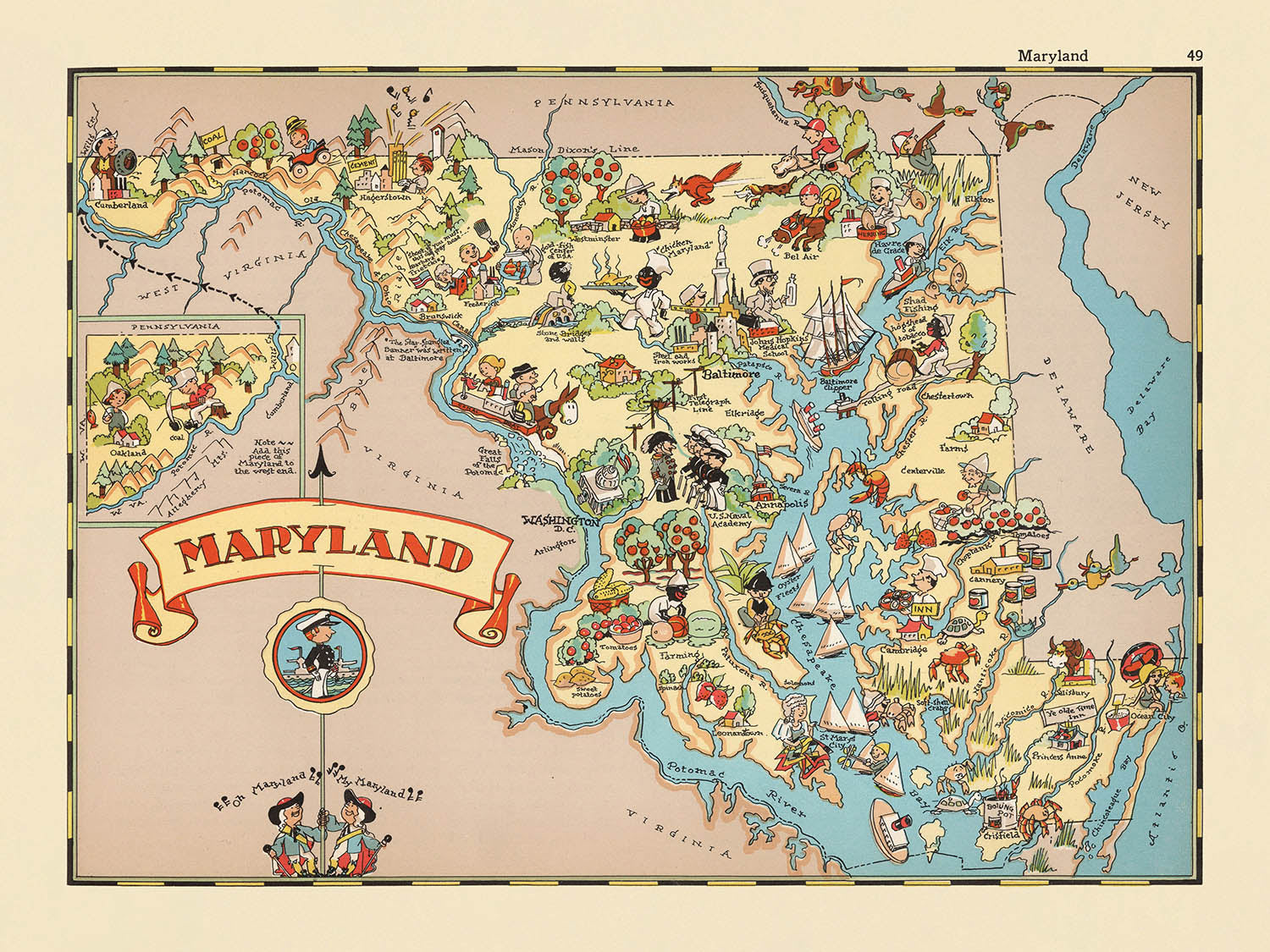
Step into the vibrant world of 1930s America with "Maryland," a captivating pictorial map originally crafted by Ruth Taylor White in 1935....
Continue readingStep into the vibrant world of 1930s America with "Maryland," a captivating pictorial map originally crafted by Ruth Taylor White in 1935. Bearing its simple yet evocative title, this map is a celebration of Maryland’s unique identity during a transformative era in American history. With every glance, you are invited to explore the state’s rich tapestry—its rolling Appalachian Mountains, the storied Chesapeake Bay, and the vital Potomac River—all rendered in White’s signature, whimsical style. The playful illustrations and lively color palette immediately evoke the spirit of the time, capturing not only the geography but also the culture and character that defined Maryland.
Ruth Taylor White, a luminary in the world of pictorial cartography, was renowned for her ability to blend artistry with storytelling. Her maps, often produced in collaboration with her husband Frank Taylor, transcended mere navigation aids, instead serving as visual narratives that brought states to life for a broad audience. In "Maryland," White’s imaginative approach is unmistakable: counties are outlined with bold clarity, while scenes of daily life, local industries, and iconic wildlife are interwoven across the landscape. Her distinctive cartoonish illustrations and vibrant hues transform the map into a delightful tableau, making it both an educational tool and a work of art.
The map’s thematic richness is immediately apparent in its depictions of Maryland’s economic and cultural lifeblood. Illustrations of tobacco fields, poultry farms, and bustling crabbing boats pay homage to the state’s agricultural and maritime heritage. The Chesapeake Bay, rendered with loving detail, anchors the map, while oyster harvesting and sailing scenes highlight the region’s deep connection to its waterways. The presence of African American workers in agricultural settings, though reflective of its era, offers a poignant window into the social and labor history of the state, capturing both the vibrancy and complexity of Maryland’s past.
Beyond its agricultural and maritime motifs, the map is alive with whimsical depictions of local customs, period clothing, and native wildlife. Ducks, fish, and other fauna are scattered playfully throughout, while the Maryland state flag and decorative borders frame the composition with patriotic flair. The Mason-Dixon Line, Appalachian highlands, and Atlantic coastline are all carefully delineated, grounding the fanciful illustrations in recognizable geography. Each visual element, from the rolling mountains in the west to the bustling shores in the east, invites the viewer to embark on a journey through Maryland’s diverse landscapes and storied borders.
Cities and towns are thoughtfully positioned across the map, from the historic streets of Annapolis to the bustling metropolis of Baltimore, and the charming communities of Frederick, Hagerstown, and Cumberland. Each settlement is depicted with an eye for both accuracy and character, reflecting their significance in the state’s social and economic fabric. This map is more than a decorative piece—it is a vibrant historical document, a testament to Ruth Taylor White’s artistic genius, and a unique window into the Maryland of yesteryear. For collectors, historians, or anyone with a passion for American heritage, "Maryland" is an extraordinary artifact that enchants and educates in equal measure.
Cities and towns on this map
- Baltimore
- Annapolis
- Frederick
- Hagerstown
- Cumberland
- Salisbury
- Cambridge
- Easton
- Rockville
- Westminster
- Elkton
- La Plata
- Chestertown
Notable Features & Landmarks
- Chesapeake Bay is prominently illustrated and labeled.
- The Potomac River is depicted along the southern border of the state.
- The Atlantic Ocean is shown to the east of Maryland.
- The Mason-Dixon Line is marked, indicating the northern boundary with Pennsylvania.
- The Appalachian Mountains are illustrated in the western part of the state.
- Illustrations of agricultural activities, such as tobacco farming and poultry, are visible.
- Depictions of crabbing and oyster harvesting, reflecting Maryland’s seafood industry.
- Images of African American workers in agricultural settings, reflecting the demographics and labor practices of the era.
- Illustrations of sailing and boating activities on the Chesapeake Bay.
- Cartoon representations of local wildlife, such as ducks and fish.
- The map includes whimsical drawings of people in period clothing, engaging in various activities.
- The state’s counties are outlined and labeled.
- The Maryland state flag is illustrated.
- The map features decorative borders with additional small illustrations relevant to Maryland’s culture and history.
Historical and design context
- The map is titled "Maryland."
- Created in 1935 by Ruth Taylor White, a well-known illustrator famous for her colorful, whimsical pictorial maps.
- The map is part of a larger series of entertaining and fanciful pictorial or cartoon atlases of the United States, popular in the early 20th century.
- Published during a period when pictorial maps were used to both educate and amuse, often reflecting the culture and stereotypes of the era.
- The artistic style is cartoonish and playful, with rich colors and exaggerated features, typical of Ruth Taylor White’s work.
- The illustrations serve as both decoration and light-hearted commentary, providing insight into how Maryland was perceived in the 1930s.
- The map is historically significant as an example of how states were represented in popular culture during the early 20th century.
- Ruth Taylor White often collaborated with her husband, Frank Taylor, on these pictorial atlases, which were widely distributed in magazines and books.
- The map provides a unique visual record of Maryland’s identity and reputation during the 1930s.
Please double check the images to make sure that a specific town or place is shown on this map. You can also get in touch and ask us to check the map for you.
This map looks great at every size, but I always recommend going for a larger size if you have space. That way you can easily make out all of the details.
This map looks amazing at sizes all the way up to 50in (125cm). If you are looking for a larger map, please get in touch.
The model in the listing images is holding the 18x24in (45x60cm) version of this map.
The fifth listing image shows an example of my map personalisation service.
If you’re looking for something slightly different, check out my collection of the best old maps to see if something else catches your eye.
Please contact me to check if a certain location, landmark or feature is shown on this map.
This would make a wonderful birthday, Christmas, Father's Day, work leaving, anniversary or housewarming gift for someone from the areas covered by this map.
This map is available as a giclée print on acid free archival matte paper, or you can buy it framed. The frame is a nice, simple black frame that suits most aesthetics. Please get in touch if you'd like a different frame colour or material. My frames are glazed with super-clear museum-grade acrylic (perspex/acrylite), which is significantly less reflective than glass, safer, and will always arrive in perfect condition.
This map is also available as a float framed canvas, sometimes known as a shadow gap framed canvas or canvas floater. The map is printed on artist's cotton canvas and then stretched over a handmade box frame. We then "float" the canvas inside a wooden frame, which is available in a range of colours (black, dark brown, oak, antique gold and white). This is a wonderful way to present a map without glazing in front. See some examples of float framed canvas maps and explore the differences between my different finishes.
For something truly unique, this map is also available in "Unique 3D", our trademarked process that dramatically transforms the map so that it has a wonderful sense of depth. We combine the original map with detailed topography and elevation data, so that mountains and the terrain really "pop". For more info and examples of 3D maps, check my Unique 3D page.
Step into the vibrant world of 1930s America with "Maryland," a captivating pictorial map originally crafted by Ruth Taylor White in 1935. Bearing its simple yet evocative title, this map is a celebration of Maryland’s unique identity during a transformative era in American history. With every glance, you are invited to explore the state’s rich tapestry—its rolling Appalachian Mountains, the storied Chesapeake Bay, and the vital Potomac River—all rendered in White’s signature, whimsical style. The playful illustrations and lively color palette immediately evoke the spirit of the time, capturing not only the geography but also the culture and character that defined Maryland.
Ruth Taylor White, a luminary in the world of pictorial cartography, was renowned for her ability to blend artistry with storytelling. Her maps, often produced in collaboration with her husband Frank Taylor, transcended mere navigation aids, instead serving as visual narratives that brought states to life for a broad audience. In "Maryland," White’s imaginative approach is unmistakable: counties are outlined with bold clarity, while scenes of daily life, local industries, and iconic wildlife are interwoven across the landscape. Her distinctive cartoonish illustrations and vibrant hues transform the map into a delightful tableau, making it both an educational tool and a work of art.
The map’s thematic richness is immediately apparent in its depictions of Maryland’s economic and cultural lifeblood. Illustrations of tobacco fields, poultry farms, and bustling crabbing boats pay homage to the state’s agricultural and maritime heritage. The Chesapeake Bay, rendered with loving detail, anchors the map, while oyster harvesting and sailing scenes highlight the region’s deep connection to its waterways. The presence of African American workers in agricultural settings, though reflective of its era, offers a poignant window into the social and labor history of the state, capturing both the vibrancy and complexity of Maryland’s past.
Beyond its agricultural and maritime motifs, the map is alive with whimsical depictions of local customs, period clothing, and native wildlife. Ducks, fish, and other fauna are scattered playfully throughout, while the Maryland state flag and decorative borders frame the composition with patriotic flair. The Mason-Dixon Line, Appalachian highlands, and Atlantic coastline are all carefully delineated, grounding the fanciful illustrations in recognizable geography. Each visual element, from the rolling mountains in the west to the bustling shores in the east, invites the viewer to embark on a journey through Maryland’s diverse landscapes and storied borders.
Cities and towns are thoughtfully positioned across the map, from the historic streets of Annapolis to the bustling metropolis of Baltimore, and the charming communities of Frederick, Hagerstown, and Cumberland. Each settlement is depicted with an eye for both accuracy and character, reflecting their significance in the state’s social and economic fabric. This map is more than a decorative piece—it is a vibrant historical document, a testament to Ruth Taylor White’s artistic genius, and a unique window into the Maryland of yesteryear. For collectors, historians, or anyone with a passion for American heritage, "Maryland" is an extraordinary artifact that enchants and educates in equal measure.
Cities and towns on this map
- Baltimore
- Annapolis
- Frederick
- Hagerstown
- Cumberland
- Salisbury
- Cambridge
- Easton
- Rockville
- Westminster
- Elkton
- La Plata
- Chestertown
Notable Features & Landmarks
- Chesapeake Bay is prominently illustrated and labeled.
- The Potomac River is depicted along the southern border of the state.
- The Atlantic Ocean is shown to the east of Maryland.
- The Mason-Dixon Line is marked, indicating the northern boundary with Pennsylvania.
- The Appalachian Mountains are illustrated in the western part of the state.
- Illustrations of agricultural activities, such as tobacco farming and poultry, are visible.
- Depictions of crabbing and oyster harvesting, reflecting Maryland’s seafood industry.
- Images of African American workers in agricultural settings, reflecting the demographics and labor practices of the era.
- Illustrations of sailing and boating activities on the Chesapeake Bay.
- Cartoon representations of local wildlife, such as ducks and fish.
- The map includes whimsical drawings of people in period clothing, engaging in various activities.
- The state’s counties are outlined and labeled.
- The Maryland state flag is illustrated.
- The map features decorative borders with additional small illustrations relevant to Maryland’s culture and history.
Historical and design context
- The map is titled "Maryland."
- Created in 1935 by Ruth Taylor White, a well-known illustrator famous for her colorful, whimsical pictorial maps.
- The map is part of a larger series of entertaining and fanciful pictorial or cartoon atlases of the United States, popular in the early 20th century.
- Published during a period when pictorial maps were used to both educate and amuse, often reflecting the culture and stereotypes of the era.
- The artistic style is cartoonish and playful, with rich colors and exaggerated features, typical of Ruth Taylor White’s work.
- The illustrations serve as both decoration and light-hearted commentary, providing insight into how Maryland was perceived in the 1930s.
- The map is historically significant as an example of how states were represented in popular culture during the early 20th century.
- Ruth Taylor White often collaborated with her husband, Frank Taylor, on these pictorial atlases, which were widely distributed in magazines and books.
- The map provides a unique visual record of Maryland’s identity and reputation during the 1930s.
Please double check the images to make sure that a specific town or place is shown on this map. You can also get in touch and ask us to check the map for you.
This map looks great at every size, but I always recommend going for a larger size if you have space. That way you can easily make out all of the details.
This map looks amazing at sizes all the way up to 50in (125cm). If you are looking for a larger map, please get in touch.
The model in the listing images is holding the 18x24in (45x60cm) version of this map.
The fifth listing image shows an example of my map personalisation service.
If you’re looking for something slightly different, check out my collection of the best old maps to see if something else catches your eye.
Please contact me to check if a certain location, landmark or feature is shown on this map.
This would make a wonderful birthday, Christmas, Father's Day, work leaving, anniversary or housewarming gift for someone from the areas covered by this map.
This map is available as a giclée print on acid free archival matte paper, or you can buy it framed. The frame is a nice, simple black frame that suits most aesthetics. Please get in touch if you'd like a different frame colour or material. My frames are glazed with super-clear museum-grade acrylic (perspex/acrylite), which is significantly less reflective than glass, safer, and will always arrive in perfect condition.
This map is also available as a float framed canvas, sometimes known as a shadow gap framed canvas or canvas floater. The map is printed on artist's cotton canvas and then stretched over a handmade box frame. We then "float" the canvas inside a wooden frame, which is available in a range of colours (black, dark brown, oak, antique gold and white). This is a wonderful way to present a map without glazing in front. See some examples of float framed canvas maps and explore the differences between my different finishes.
For something truly unique, this map is also available in "Unique 3D", our trademarked process that dramatically transforms the map so that it has a wonderful sense of depth. We combine the original map with detailed topography and elevation data, so that mountains and the terrain really "pop". For more info and examples of 3D maps, check my Unique 3D page.
Many of our maps and art prints are chosen as thoughtful gifts for homes, offices, studies and meaningful places.
Choose a framed option for the easiest ready-to-hang gift, or choose an unframed print if the recipient may prefer to select their own frame.
We make orders locally in 23 countries around the world, so gifts can often be produced close to the recipient. This helps them arrive faster, travel more safely, and avoid customs or import duty surprises.
- We can deliver directly to the recipient
- Framed pieces arrive ready to hang
- Unframed prints are carefully packed in a strong protective tube
- Almost every order is made locally, for faster, safer gifting
- 90-day returns give the recipient time to decide
If you are not sure what to choose, please contact us. We can help you pick the right map, size, finish or delivery option.
Most orders are made locally and delivered in around 2–3 working days, depending on the product, size and destination.
We print and frame maps and artwork in 23 countries around the world, so your order is usually made close to you or your recipient. That means faster delivery, less time in transit, and no customs or import duty surprises.
Personalised and customised pieces usually take an extra 1–2 working days, because we prepare your design and send it to you for approval before printing.
Very large framed orders can take a little longer, as they need extra care in production and delivery.
Every order is carefully packaged: unframed prints are sent in a strong protective tube, while framed pieces are securely packed with protective materials around the frame.
If you need your order by a particular date, please contact us before ordering. We’ll check the best production route and delivery option for your location.
Express delivery is available at checkout for most countries. Next-day delivery is available in the UK, US, Singapore and the UAE.
Your order is covered by our 90-day returns policy and 10-year guarantee.
Our standard frame is a gallery-style black ash hardwood frame, with a simple, modern look. It is approximately 20mm (0.8in) wide. You can also view some lovely customer photos of framed maps and art.
We use super-clear acrylic glazing, also known as Perspex or Acrylite, instead of traditional glass. It is lighter, safer, and has lower reflectivity, giving the artwork a clearer, cleaner appearance.
Six standard frame colours are available at no extra cost: black, dark brown, dark grey, oak, white, and antique gold. Custom framing and mounting/matting is also available for customers looking for something more specific.
Most maps, art prints, and illustrations are also available as a framed canvas. We use matte cotton canvas, stretch it over a sustainably sourced wooden box frame, and then float the piece within a wooden outer frame. The finished result is beautifully presented, with no glazing between you and the artwork.
All frames are supplied ready to hang, with either string or brackets fitted to the back. Very large frames will include heavy-duty hanging plates and/or a mounting baton. If you have any questions, please get in touch.
We can also supply old maps and artwork on canvas, foam board, cotton rag, and other materials.
If you would prefer to frame your map or artwork yourself, please read our size guide before ordering.
My maps are extremely high quality reproductions of original maps.
I source original, rare maps from libraries, auction houses and private collections around the world, restore them at my London workshop, and then use specialist giclée inks and printers to create beautiful maps that look even better than the original.
My maps are printed on acid-free archival matte (not glossy) paper that feels very high quality and almost like card. In technical terms the paper weight/thickness is 10mil/200gsm. It's perfect for framing.
I print with Epson ultrachrome giclée UV fade resistant pigment inks - some of the best inks you can find.
I can also make maps on canvas, cotton rag and other exotic materials.
Learn more about The Unique Maps Co.
Map personalisation
If you're looking for the perfect anniversary or housewarming gift, I can personalise your map to make it truly unique. For example, I can add a short message, or highlight an important location, or add your family's coat of arms.
The options are almost infinite. Please see my map personalisation page for some wonderful examples of what's possible.
To order a personalised map, select "personalise your map" before adding it to your basket.
Get in touch if you're looking for more complex customisations and personalisations.
Map ageing
I have been asked hundreds of times over the years by customers if they could buy a map that looks even older.
Well, now you can, by selecting Aged before you add a map to your basket.
All the product photos you see on this page show the map in its Original form. This is what the map looks like today.
If you select Aged, I will age your map by hand, using a special and unique process developed through years of studying old maps, talking to researchers to understand the chemistry of aging paper, and of course... lots of practice!
If you're unsure, stick to the Original colour of the map. If you want something a bit darker and older looking, go for Aged.
If you are not happy with your order for any reason, contact me and I'll get it fixed ASAP, free of charge. Please see my returns and refund policy for more information.
I am very confident you will like your restored map or art print. I have been doing this since 1984. I'm a 5-star Etsy seller. I have sold tens of thousands of maps and art prints and have over 5,000 real 5-star reviews. My work has been featured in interior design magazines, on the BBC, and on the walls of dozens of 5-star hotels.
I use a unique process to restore maps and artwork that is massively time consuming and labour intensive. Hunting down the original maps and illustrations can take months. I use state of the art and eye-wateringly expensive technology to scan and restore them. As a result, I guarantee my maps and art prints are a cut above the rest. I stand by my products and will always make sure you're 100% happy with what you receive.
Almost all of my maps and art prints look amazing at large sizes (200cm, 6.5ft+) and I can frame and deliver them to you as well, via special oversized courier. Contact me to discuss your specific needs.
Or try searching for something!


