


Pictorial Map of Kentucky by Ruth Taylor White, 1935: Louisville, Lexington, Horse Racing, Bourbon, Appalachians
20% off 2 — 33% off 3
Add any two eligible items to your bag to receive 20% off. Add a third and it will be complimentary (equivalent to 33% off when purchasing three).
No code needed — the offer applies automatically at checkout.
Valid on all standard maps and fine art prints. You can mix and match any designs.
If you’d like to ship items to multiple addresses, please contact us before placing your order.
Custom and bespoke commissions are excluded.
Contact us if you have any questions
 Designed in London Made in the EU
Designed in London • Made in the EU
Designed in London Made in the EU
Designed in London • Made in the EU

Choose your size
Choose your finish


(More info)
Gift message & custom finish

If you want to add a gift message, or a finish (jigsaw, aluminium board, etc.) that is not available here, please request it in the "order note" when you check out.
Every order is custom made, so if you need the size adjusted slightly, or printed on an unusual material, just let us know. We've done thousands of custom orders over the years, so there's (almost) nothing we can't manage.
You can also contact us before you order, if you prefer!

- Made locally for fast, safe delivery
- No import duty or hidden fees
- Need advice? Message us on WhatsApp
Own a piece of history
7,000+ 5 star reviews


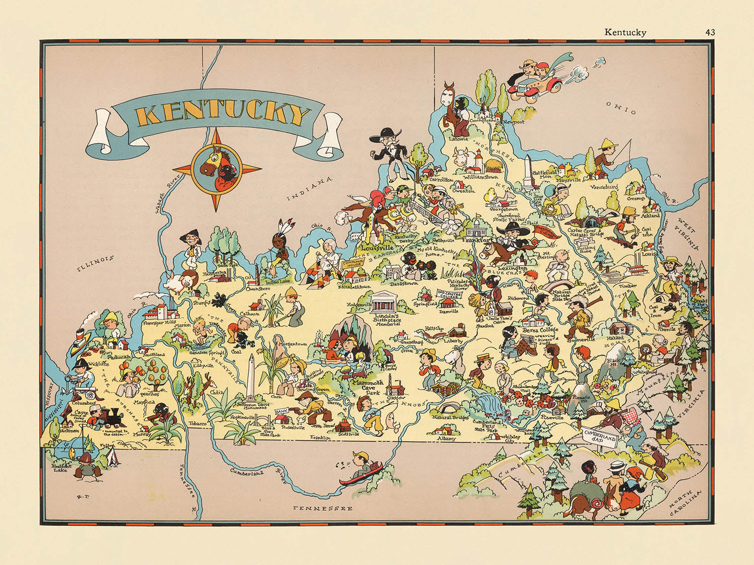
Step into the vibrant world of 1930s Americana with “Kentucky,” the original title of this captivating pictorial map created by Ruth Taylor White in 1935. Far more than a mere geographical reference, this map is a celebration of Kentucky’s unique character, rendered in a whimsical, cartoon-like style that immediately draws the eye. Each county is outlined and labeled, but it is the riot of colorful illustrations—depicting everything from spirited horse races to bustling riverboats—that truly brings the Bluegrass State to life. The map’s decorative border and title cartouche add a touch of playful elegance, making it a delightful fusion of artistry and cartographic tradition.
Ruth Taylor White, the visionary behind this map, was renowned for her ability to blend humor, artistry, and social commentary in her pictorial works. Collaborating frequently with her husband, Frank Taylor, she contributed to a series of fanciful atlases that captured the essence of American states through the lens of popular culture and local lore. Her maps are prized not only for their aesthetic appeal but also for their insightful portrayal of the regional identities and stereotypes of the era. “Kentucky” stands as a testament to her talent, offering a window into the state’s cultural landscape as it was perceived in the early twentieth century.
The map’s design is a masterclass in thematic cartography, with each illustrated vignette chosen to highlight a defining aspect of Kentucky’s heritage. Scenes of thoroughbred horses and racetracks pay homage to the state’s legendary equestrian traditions, while depictions of tobacco barns and bourbon barrels underscore its agricultural and distilling prowess. The inclusion of coal mining operations and Appalachian mountain ranges speaks to the diversity of Kentucky’s economy and geography. These lively illustrations do not just embellish the map—they narrate the story of a region shaped by its land, labor, and leisure.
What sets this map apart is its ability to weave together the natural and human elements of Kentucky with both accuracy and charm. Major rivers like the Ohio are animated with paddlewheelers, while the rolling hills and valleys of the state are dotted with livestock and musicians, evoking the rhythms of bluegrass culture. Rather than focusing on specific historic landmarks or events, the map captures the broader tapestry of daily life, from bustling towns to tranquil farmlands. Each scene is rendered with a sense of humor and affection, making the map as enjoyable to explore as it is informative.
The cities and towns featured—ranging from Louisville and Lexington to smaller communities like Hazard and Pineville—are carefully placed, reflecting the state’s settlement patterns during the 1930s. Their presence anchors the map’s fanciful illustrations in real geography, inviting viewers to trace the contours of Kentucky’s past and present. As a historical artifact, “Kentucky” is more than a map; it is a visual narrative that invites collectors and enthusiasts alike to experience the spirit of a bygone era, where artistry and cartography meet in a celebration of place and identity.
Cities and towns on this map
- Louisville
- Lexington
- Bowling Green
- Owensboro
- Covington
- Hopkinsville
- Paducah
- Ashland
- Frankfort
- Henderson
- Winchester
- Somerset
- Middlesboro
- Mayfield
- Danville
- Hazard
- Pineville
Notable Features & Landmarks
- Illustrations of horses and horse racing, referencing Kentucky's famous horse industry.
- Depictions of tobacco farming and barns, highlighting the state's agricultural heritage.
- Images of bourbon barrels and distilleries, referencing Kentucky's bourbon industry.
- Cartoon figures in traditional dress, representing local culture and folklore.
- Drawings of coal mining scenes, indicating the importance of coal in Kentucky's economy.
- Illustrations of riverboats on the Ohio River, referencing Kentucky's river trade.
- Artistic renderings of the Appalachian Mountains in the eastern part of the state.
- Scenes of bluegrass music and musicians, alluding to Kentucky's musical traditions.
- Images of livestock, such as cattle and pigs, reflecting the state's farming activities.
- Labeled county boundaries and names, though not all are legible at a glance.
- Decorative border and title cartouche in a whimsical style.
- The map is filled with colorful, playful illustrations rather than standard map symbols.
Historical and design context
- Name of the map: Kentucky (original title: Kentucky.)
- Mapmaker: Ruth Taylor White, renowned for her whimsical and artistic pictorial maps.
- Date of creation: 1935.
- Part of a fanciful pictorial or cartoon atlas of the United States, blending art, humor, and geography.
- The map uses vibrant, cartoon-like illustrations to depict stereotypical and notable scenes, people, and activities associated with Kentucky in the 1930s.
- The map reflects the perceptions and stereotypes of Kentucky in the early 20th century, offering insight into how the state was viewed culturally and economically at the time.
- The map serves as both a geographical representation and a cultural artifact, capturing the spirit and identity of Kentucky during the 1930s.
- The map is a product of its time, reflecting the humor, biases, and artistic conventions of the 1930s.
- The map is part of a larger trend in the 1930s of creating pictorial maps that blend art, humor, and geography.
- The map is a delightful artifact for collectors and those interested in the intersection of art and cartography.
Please double check the images to make sure that a specific town or place is shown on this map. You can also get in touch and ask us to check the map for you.
This map looks great at every size, but I always recommend going for a larger size if you have space. That way you can easily make out all of the details.
This map looks amazing at sizes all the way up to 50in (125cm). If you are looking for a larger map, please get in touch.
The model in the listing images is holding the 18x24in (45x60cm) version of this map.
The fifth listing image shows an example of my map personalisation service.
If you’re looking for something slightly different, check out my collection of the best old maps to see if something else catches your eye.
Please contact me to check if a certain location, landmark or feature is shown on this map.
This would make a wonderful birthday, Christmas, Father's Day, work leaving, anniversary or housewarming gift for someone from the areas covered by this map.
This map is available as a giclée print on acid free archival matte paper, or you can buy it framed. The frame is a nice, simple black frame that suits most aesthetics. Please get in touch if you'd like a different frame colour or material. My frames are glazed with super-clear museum-grade acrylic (perspex/acrylite), which is significantly less reflective than glass, safer, and will always arrive in perfect condition.
This map is also available as a float framed canvas, sometimes known as a shadow gap framed canvas or canvas floater. The map is printed on artist's cotton canvas and then stretched over a handmade box frame. We then "float" the canvas inside a wooden frame, which is available in a range of colours (black, dark brown, oak, antique gold and white). This is a wonderful way to present a map without glazing in front. See some examples of float framed canvas maps and explore the differences between my different finishes.
For something truly unique, this map is also available in "Unique 3D", our trademarked process that dramatically transforms the map so that it has a wonderful sense of depth. We combine the original map with detailed topography and elevation data, so that mountains and the terrain really "pop". For more info and examples of 3D maps, check my Unique 3D page.
Many of our maps and art prints are chosen as thoughtful gifts for homes, offices, studies and meaningful places.
Choose a framed option for the easiest ready-to-hang gift, or choose an unframed print if the recipient may prefer to select their own frame.
We make orders locally in 23 countries around the world, so gifts can often be produced close to the recipient. This helps them arrive faster, travel more safely, and avoid customs or import duty surprises.
- We can deliver directly to the recipient
- Framed pieces arrive ready to hang
- Unframed prints are carefully packed in a strong protective tube
- Almost every order is made locally, for faster, safer gifting
- 90-day returns give the recipient time to decide
If you are not sure what to choose, please contact us. We can help you pick the right map, size, finish or delivery option.
Most orders are made locally and delivered in around 2–3 working days, depending on the product, size and destination.
We print and frame maps and artwork in 23 countries around the world, so your order is usually made close to you or your recipient. That means faster delivery, less time in transit, and no customs or import duty surprises.
Personalised and customised pieces usually take an extra 1–2 working days, because we prepare your design and send it to you for approval before printing.
Very large framed orders can take a little longer, as they need extra care in production and delivery.
Every order is carefully packaged: unframed prints are sent in a strong protective tube, while framed pieces are securely packed with protective materials around the frame.
If you need your order by a particular date, please contact us before ordering. We’ll check the best production route and delivery option for your location.
Express delivery is available at checkout for most countries. Next-day delivery is available in the UK, US, Singapore and the UAE.
Your order is covered by our 90-day returns policy and 10-year guarantee.
Our standard frame is a gallery-style black ash hardwood frame, with a simple, modern look. It is approximately 20mm (0.8in) wide. You can also view some lovely customer photos of framed maps and art.
We use super-clear acrylic glazing, also known as Perspex or Acrylite, instead of traditional glass. It is lighter, safer, and has lower reflectivity, giving the artwork a clearer, cleaner appearance.
Six standard frame colours are available at no extra cost: black, dark brown, dark grey, oak, white, and antique gold. Custom framing and mounting/matting is also available for customers looking for something more specific.
Most maps, art prints, and illustrations are also available as a framed canvas. We use matte cotton canvas, stretch it over a sustainably sourced wooden box frame, and then float the piece within a wooden outer frame. The finished result is beautifully presented, with no glazing between you and the artwork.
All frames are supplied ready to hang, with either string or brackets fitted to the back. Very large frames will include heavy-duty hanging plates and/or a mounting baton. If you have any questions, please get in touch.
We can also supply old maps and artwork on canvas, foam board, cotton rag, and other materials.
If you would prefer to frame your map or artwork yourself, please read our size guide before ordering.
My maps are extremely high quality reproductions of original maps.
I source original, rare maps from libraries, auction houses and private collections around the world, restore them at my London workshop, and then use specialist giclée inks and printers to create beautiful maps that look even better than the original.
My maps are printed on acid-free archival matte (not glossy) paper that feels very high quality and almost like card. In technical terms the paper weight/thickness is 10mil/200gsm. It's perfect for framing.
I print with Epson ultrachrome giclée UV fade resistant pigment inks - some of the best inks you can find.
I can also make maps on canvas, cotton rag and other exotic materials.
Learn more about The Unique Maps Co.
Map personalisation
If you're looking for the perfect anniversary or housewarming gift, I can personalise your map to make it truly unique. For example, I can add a short message, or highlight an important location, or add your family's coat of arms.
The options are almost infinite. Please see my map personalisation page for some wonderful examples of what's possible.
To order a personalised map, select "personalise your map" before adding it to your basket.
Get in touch if you're looking for more complex customisations and personalisations.
Map ageing
I have been asked hundreds of times over the years by customers if they could buy a map that looks even older.
Well, now you can, by selecting Aged before you add a map to your basket.
All the product photos you see on this page show the map in its Original form. This is what the map looks like today.
If you select Aged, I will age your map by hand, using a special and unique process developed through years of studying old maps, talking to researchers to understand the chemistry of aging paper, and of course... lots of practice!
If you're unsure, stick to the Original colour of the map. If you want something a bit darker and older looking, go for Aged.
If you are not happy with your order for any reason, contact me and I'll get it fixed ASAP, free of charge. Please see my returns and refund policy for more information.
I am very confident you will like your restored map or art print. I have been doing this since 1984. I'm a 5-star Etsy seller. I have sold tens of thousands of maps and art prints and have over 5,000 real 5-star reviews. My work has been featured in interior design magazines, on the BBC, and on the walls of dozens of 5-star hotels.
I use a unique process to restore maps and artwork that is massively time consuming and labour intensive. Hunting down the original maps and illustrations can take months. I use state of the art and eye-wateringly expensive technology to scan and restore them. As a result, I guarantee my maps and art prints are a cut above the rest. I stand by my products and will always make sure you're 100% happy with what you receive.
Almost all of my maps and art prints look amazing at large sizes (200cm, 6.5ft+) and I can frame and deliver them to you as well, via special oversized courier. Contact me to discuss your specific needs.
Or try searching for something!


