


Rare Old Pictorial Map of Japan vs. Dutch East Indies Colonies in World War 2, 1940
The Collector’s Offer
Choose two eligible works and receive 20% off both. Choose three and the lowest-priced one is complimentary, a maximum saving of 33%.
Mix and match eligible standard maps and fine-art prints. No code is required; the offer is applied automatically at checkout.
Standard made-to-order configurations are included. Bespoke sizes, personalised designs and commissioned work are excluded.
Need delivery to different addresses? Contact us before ordering.The Collector’s Offer
Choose two eligible works and receive 20% off both. Choose three and the lowest-priced one is complimentary, a maximum saving of 33%.
Mix and match eligible standard maps and fine-art prints. No code is required; the offer is applied automatically at checkout.
Standard made-to-order configurations are included. Bespoke sizes, personalised designs and commissioned work are excluded.
Need delivery to different addresses? Contact us before ordering. Designed in London Made in the EU
Designed in London • Made in the EU
Designed in London Made in the EU
Designed in London • Made in the EU

Restored from the original 1940 map and printed to museum-grade archival standards. Read the story behind this map
Choose your size
Choose your finish


(More info)
Gift message & custom finish

If you want to add a gift message, or a finish (jigsaw, aluminium board, etc.) that is not available here, please request it in the "order note" when you check out.
Every order is custom made, so if you need the size adjusted slightly, or printed on an unusual material, just let us know. We've done thousands of custom orders over the years, so there's (almost) nothing we can't manage.
You can also contact us before you order, if you prefer!

- Made locally for fast, safe delivery
- No import duty or hidden fees
- Need advice? Call us or message on WhatsApp
Own a piece of history
8,000+ five-star reviews


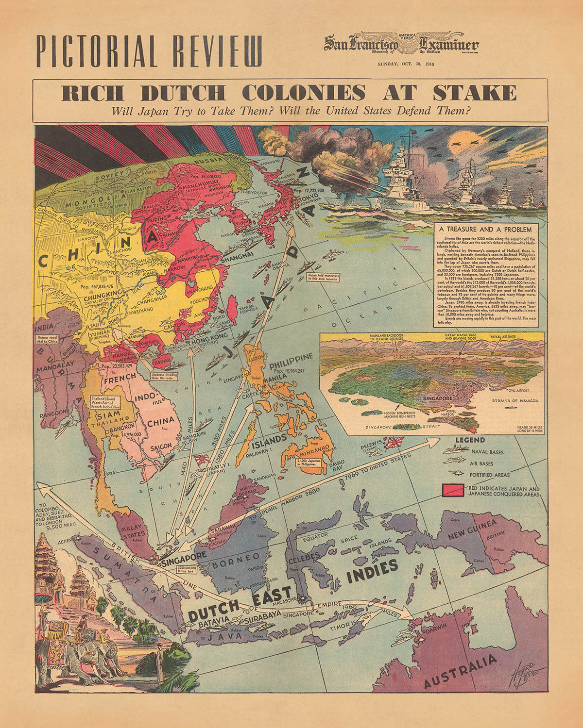
Embark on a historical journey with the "Rich Dutch Colonies at Stake" map, a vivid portrayal of geopolitical tensions and colonial interests...
Continue readingEmbark on a historical journey with the "Rich Dutch Colonies at Stake" map, a vivid portrayal of geopolitical tensions and colonial interests in the early 20th century. Crafted by Howard Burke for the San Francisco Examiner on October 20, 1940, this map is a masterpiece of pictorial cartography, capturing a moment when the world stood on the brink of widespread conflict. As the oldest continuously published newspaper in San Francisco, the Examiner provided its readers with insightful analysis through such compelling visual storytelling. This map, in particular, serves as a window into the era's complexities, illustrating the strategic significance of the Dutch East Indies and the looming threat of Japanese expansion.
The design and style of this map are as informative as they are visually striking. Employing a thematic approach, Burke's work is a color pictorial map that not only highlights territories but also embellishes them with vignette illustrations, such as elephants and temples, that evoke the cultural and geographical essence of the regions depicted. A bird's eye view inset of Singapore underscores its strategic importance, while areas under Japanese control are marked in red, offering a clear and immediate understanding of the geopolitical landscape. This map goes beyond mere geography, providing a narrative through its design.
The map's thematic content is rich and multifaceted, touching on critical issues such as Japan's invasion of French Indochina, the defense of the Dutch colonies by America, and the resource-rich Dutch East Indies. These topics are not just historical footnotes; they are the threads that weave the fabric of this period's global tensions. The map skillfully illustrates potential conflicts between Japan and the United States, hinting at the broader implications for global power dynamics. Through its detailed depiction of military and national symbols, including soldiers from various nations and warships, the map offers an encapsulated view of the era's international relations.
Howard Burke's creation is not just a map but a historical document that captures the essence of a pivotal moment in world history. Its detailed illustrations and annotations provide insights into the military, economic, and cultural stakes of the time. From the depiction of natural resources like rubber plantations and mines to the strategic representation of military assets, the map serves as a comprehensive guide to understanding the complex interplay of forces in the Asia-Pacific region. It is a testament to the mapmaker's skill in conveying intricate geopolitical narratives through the art of cartography.
For enthusiasts of history, cartography, or the art of storytelling through maps, "Rich Dutch Colonies at Stake" is more than a collectible. It is a piece of history, a narrative captured in color and line, offering insights into the challenges and strategies of nations caught in the whirlwind of global ambition and conflict. This map is not just a visual representation; it is a portal to the past, inviting viewers to explore the depths of historical intrigue and the artistry of mapmaking.
Countries and regions on this map
- Australia
- Borneo
- Burma
- Cambodia
- China
- Dutch East Indies
- French Indo-China
- India
- Japan
- Java
- Malaya
- Manchuria
- Mongolia
- New Guinea
- North Borneo
- Pacific Ocean
- Philippines
- Russia
- Sarawak
- Siam
- Singapore
- South China Sea
- Sumatra
- Vietnam
Historical and design context
- Name: Rich Dutch Colonies at Stake
- Date: October 20, 1940
- Mapmaker/Publisher: Howard Burke, San Francisco Examiner
- Context: The San Francisco Examiner is a daily newspaper published in San Francisco, California. It was founded in 1865 and is the oldest continuously published newspaper in the city.
- Topics/Themes: Rich Dutch colonies at stake, Japan's invasion of French Indochina, America's role in defending the Dutch colonies, Strategic importance of Singapore, Resources of the Dutch East Indies, Potential conflict between Japan and the United States
- Design/Style: Pictorial map, Color, Vignette illustration, Inset map, Bird's eye view, Relief shown pictorially
- Historical significance/Context: The map was created at a time when Japan was expanding its empire in the Pacific, showing the strategic importance of the Dutch East Indies and the potential for conflict between Japan and the United States.
Please double check the images to make sure that a specific town or place is shown on this map. You can also get in touch and ask us to check the map for you.
This map looks great at every size, but I always recommend going for a larger size if you have space. That way you can easily make out all of the details.
This map looks amazing at sizes all the way up to 70in (180cm). If you are looking for a larger map, please get in touch.
The model in the listing images is holding the 16x20in (40x50cm) version of this map.
The fifth listing image shows an example of my map personalisation service.
If you’re looking for something slightly different, check out my collection of the best old maps to see if something else catches your eye.
Please contact me to check if a certain location, landmark or feature is shown on this map.
This would make a wonderful birthday, Christmas, Father's Day, work leaving, anniversary or housewarming gift for someone from the areas covered by this map.
This map is available as a giclée print on acid free archival matte paper, or you can buy it framed. The frame is a nice, simple black frame that suits most aesthetics. Please get in touch if you'd like a different frame colour or material. My frames are glazed with super-clear museum-grade acrylic (perspex/acrylite), which is significantly less reflective than glass, safer, and will always arrive in perfect condition.
This map is also available as a float framed canvas, sometimes known as a shadow gap framed canvas or canvas floater. The map is printed on artist's cotton canvas and then stretched over a handmade box frame. We then "float" the canvas inside a wooden frame, which is available in a range of colours (black, dark brown, oak, antique gold and white). This is a wonderful way to present a map without glazing in front. See some examples of float framed canvas maps and explore the differences between my different finishes.
For something truly unique, this map is also available in "Unique 3D", our trademarked process that dramatically transforms the map so that it has a wonderful sense of depth. We combine the original map with detailed topography and elevation data, so that mountains and the terrain really "pop". For more info and examples of 3D maps, check my Unique 3D page.
Embark on a historical journey with the "Rich Dutch Colonies at Stake" map, a vivid portrayal of geopolitical tensions and colonial interests in the early 20th century. Crafted by Howard Burke for the San Francisco Examiner on October 20, 1940, this map is a masterpiece of pictorial cartography, capturing a moment when the world stood on the brink of widespread conflict. As the oldest continuously published newspaper in San Francisco, the Examiner provided its readers with insightful analysis through such compelling visual storytelling. This map, in particular, serves as a window into the era's complexities, illustrating the strategic significance of the Dutch East Indies and the looming threat of Japanese expansion.
The design and style of this map are as informative as they are visually striking. Employing a thematic approach, Burke's work is a color pictorial map that not only highlights territories but also embellishes them with vignette illustrations, such as elephants and temples, that evoke the cultural and geographical essence of the regions depicted. A bird's eye view inset of Singapore underscores its strategic importance, while areas under Japanese control are marked in red, offering a clear and immediate understanding of the geopolitical landscape. This map goes beyond mere geography, providing a narrative through its design.
The map's thematic content is rich and multifaceted, touching on critical issues such as Japan's invasion of French Indochina, the defense of the Dutch colonies by America, and the resource-rich Dutch East Indies. These topics are not just historical footnotes; they are the threads that weave the fabric of this period's global tensions. The map skillfully illustrates potential conflicts between Japan and the United States, hinting at the broader implications for global power dynamics. Through its detailed depiction of military and national symbols, including soldiers from various nations and warships, the map offers an encapsulated view of the era's international relations.
Howard Burke's creation is not just a map but a historical document that captures the essence of a pivotal moment in world history. Its detailed illustrations and annotations provide insights into the military, economic, and cultural stakes of the time. From the depiction of natural resources like rubber plantations and mines to the strategic representation of military assets, the map serves as a comprehensive guide to understanding the complex interplay of forces in the Asia-Pacific region. It is a testament to the mapmaker's skill in conveying intricate geopolitical narratives through the art of cartography.
For enthusiasts of history, cartography, or the art of storytelling through maps, "Rich Dutch Colonies at Stake" is more than a collectible. It is a piece of history, a narrative captured in color and line, offering insights into the challenges and strategies of nations caught in the whirlwind of global ambition and conflict. This map is not just a visual representation; it is a portal to the past, inviting viewers to explore the depths of historical intrigue and the artistry of mapmaking.
Countries and regions on this map
- Australia
- Borneo
- Burma
- Cambodia
- China
- Dutch East Indies
- French Indo-China
- India
- Japan
- Java
- Malaya
- Manchuria
- Mongolia
- New Guinea
- North Borneo
- Pacific Ocean
- Philippines
- Russia
- Sarawak
- Siam
- Singapore
- South China Sea
- Sumatra
- Vietnam
Historical and design context
- Name: Rich Dutch Colonies at Stake
- Date: October 20, 1940
- Mapmaker/Publisher: Howard Burke, San Francisco Examiner
- Context: The San Francisco Examiner is a daily newspaper published in San Francisco, California. It was founded in 1865 and is the oldest continuously published newspaper in the city.
- Topics/Themes: Rich Dutch colonies at stake, Japan's invasion of French Indochina, America's role in defending the Dutch colonies, Strategic importance of Singapore, Resources of the Dutch East Indies, Potential conflict between Japan and the United States
- Design/Style: Pictorial map, Color, Vignette illustration, Inset map, Bird's eye view, Relief shown pictorially
- Historical significance/Context: The map was created at a time when Japan was expanding its empire in the Pacific, showing the strategic importance of the Dutch East Indies and the potential for conflict between Japan and the United States.
Please double check the images to make sure that a specific town or place is shown on this map. You can also get in touch and ask us to check the map for you.
This map looks great at every size, but I always recommend going for a larger size if you have space. That way you can easily make out all of the details.
This map looks amazing at sizes all the way up to 70in (180cm). If you are looking for a larger map, please get in touch.
The model in the listing images is holding the 16x20in (40x50cm) version of this map.
The fifth listing image shows an example of my map personalisation service.
If you’re looking for something slightly different, check out my collection of the best old maps to see if something else catches your eye.
Please contact me to check if a certain location, landmark or feature is shown on this map.
This would make a wonderful birthday, Christmas, Father's Day, work leaving, anniversary or housewarming gift for someone from the areas covered by this map.
This map is available as a giclée print on acid free archival matte paper, or you can buy it framed. The frame is a nice, simple black frame that suits most aesthetics. Please get in touch if you'd like a different frame colour or material. My frames are glazed with super-clear museum-grade acrylic (perspex/acrylite), which is significantly less reflective than glass, safer, and will always arrive in perfect condition.
This map is also available as a float framed canvas, sometimes known as a shadow gap framed canvas or canvas floater. The map is printed on artist's cotton canvas and then stretched over a handmade box frame. We then "float" the canvas inside a wooden frame, which is available in a range of colours (black, dark brown, oak, antique gold and white). This is a wonderful way to present a map without glazing in front. See some examples of float framed canvas maps and explore the differences between my different finishes.
For something truly unique, this map is also available in "Unique 3D", our trademarked process that dramatically transforms the map so that it has a wonderful sense of depth. We combine the original map with detailed topography and elevation data, so that mountains and the terrain really "pop". For more info and examples of 3D maps, check my Unique 3D page.
Many of our maps and art prints are chosen as thoughtful gifts for homes, offices, studies and meaningful places.
Choose a framed option for the easiest ready-to-hang gift, or choose an unframed print if the recipient may prefer to select their own frame.
We make orders locally in 23 countries around the world, so gifts can often be produced close to the recipient. This helps them arrive faster, travel more safely, and avoid customs or import duty surprises.
- We can deliver directly to the recipient
- Framed pieces arrive ready to hang
- Unframed prints are carefully packed in a strong protective tube
- Almost every order is made locally, for faster, safer gifting
- 90-day returns give the recipient time to decide
If you are not sure what to choose, please contact us. We can help you pick the right map, size, finish or delivery option.
Most orders are made locally and delivered in around 2–3 working days, depending on the product, size and destination.
We print and frame maps and artwork in 23 countries around the world, so your order is usually made close to you or your recipient. That means faster delivery, less time in transit, and no customs or import duty surprises.
Personalised and customised pieces usually take an extra 1–2 working days, because we prepare your design and send it to you for approval before printing.
Very large framed orders can take a little longer, as they need extra care in production and delivery.
Every order is carefully packaged: unframed prints are sent in a strong protective tube, while framed pieces are securely packed with protective materials around the frame.
If you need your order by a particular date, please contact us before ordering. We’ll check the best production route and delivery option for your location.
Express delivery is available at checkout for most countries. Next-day delivery is available in the UK, US, Singapore and the UAE.
Your order is covered by our 90-day returns policy and 10-year guarantee.
Our standard frame is a gallery-style black ash hardwood frame, with a simple, modern look. It is approximately 20mm (0.8in) wide. You can also view some lovely customer photos of framed maps and art.
We use super-clear acrylic glazing, also known as Perspex or Acrylite, instead of traditional glass. It is lighter, safer, and has lower reflectivity, giving the artwork a clearer, cleaner appearance.
Six standard frame colours are available at no extra cost: black, dark brown, dark grey, oak, white, and antique gold. Custom framing and mounting/matting is also available for customers looking for something more specific.
Most maps, art prints, and illustrations are also available as a framed canvas. We use matte cotton canvas, stretch it over a sustainably sourced wooden box frame, and then float the piece within a wooden outer frame. The finished result is beautifully presented, with no glazing between you and the artwork.
All frames are supplied ready to hang, with either string or brackets fitted to the back. Very large frames will include heavy-duty hanging plates and/or a mounting baton. If you have any questions, please get in touch.
We can also supply old maps and artwork on canvas, foam board, cotton rag, and other materials.
If you would prefer to frame your map or artwork yourself, please read our size guide before ordering.
My maps are extremely high quality reproductions of original maps.
I source original, rare maps from libraries, auction houses and private collections around the world, restore them at my London workshop, and then use specialist giclée inks and printers to create beautiful maps that look even better than the original.
My maps are printed on acid-free archival matte (not glossy) paper that feels very high quality and almost like card. In technical terms the paper weight/thickness is 10mil/200gsm. It's perfect for framing.
I print with Epson ultrachrome giclée UV fade resistant pigment inks - some of the best inks you can find.
I can also make maps on canvas, cotton rag and other exotic materials.
Learn more about The Unique Maps Co.
Map personalisation
If you're looking for the perfect anniversary or housewarming gift, I can personalise your map to make it truly unique. For example, I can add a short message, or highlight an important location, or add your family's coat of arms.
The options are almost infinite. Please see my map personalisation page for some wonderful examples of what's possible.
To order a personalised map, select "personalise your map" before adding it to your basket.
Get in touch if you're looking for more complex customisations and personalisations.
Map ageing
I have been asked hundreds of times over the years by customers if they could buy a map that looks even older.
Well, now you can, by selecting Aged before you add a map to your basket.
All the product photos you see on this page show the map in its Original form. This is what the map looks like today.
If you select Aged, I will age your map by hand, using a special and unique process developed through years of studying old maps, talking to researchers to understand the chemistry of aging paper, and of course... lots of practice!
If you're unsure, stick to the Original colour of the map. If you want something a bit darker and older looking, go for Aged.
If you are not happy with your order for any reason, contact me and I'll get it fixed ASAP, free of charge. Please see my returns and refund policy for more information.
I am very confident you will like your restored map or art print. I have been doing this since 1984. I'm a 5-star Etsy seller. I have sold tens of thousands of maps and art prints and have over 5,000 real 5-star reviews. My work has been featured in interior design magazines, on the BBC, and on the walls of dozens of 5-star hotels.
I use a unique process to restore maps and artwork that is massively time consuming and labour intensive. Hunting down the original maps and illustrations can take months. I use state of the art and eye-wateringly expensive technology to scan and restore them. As a result, I guarantee my maps and art prints are a cut above the rest. I stand by my products and will always make sure you're 100% happy with what you receive.
Almost all of my maps and art prints look amazing at large sizes (200cm, 6.5ft+) and I can frame and deliver them to you as well, via special oversized courier. Contact me to discuss your specific needs.
Or try searching for something!


