

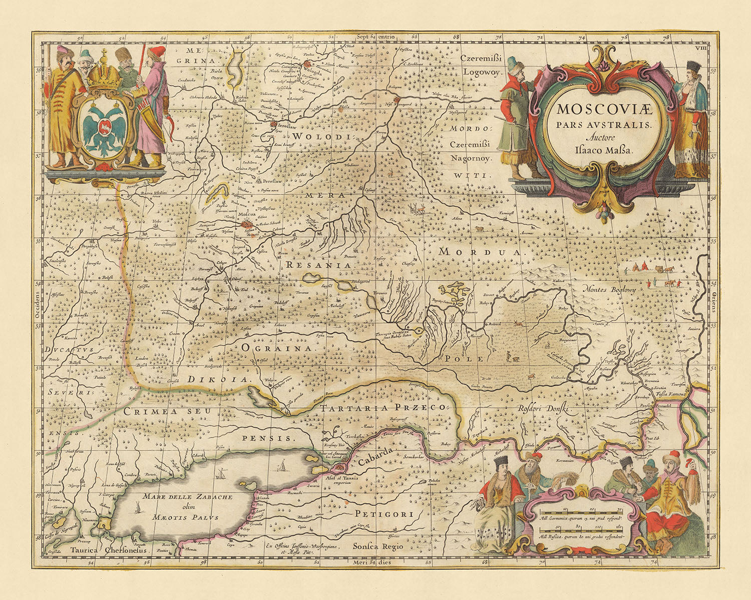


Rare Old Map of Southern Russia by Visscher, 1690: Moscow, Yaroslavl, Vologda, Nizhny Novgorod, Rostov-on-Don
20% off 2 — 33% off 3
Add any two eligible items to your bag to receive 20% off. Add a third and it will be complimentary (equivalent to 33% off when purchasing three).
No code needed — the offer applies automatically at checkout.
Valid on all standard maps and fine art prints. You can mix and match any designs.
If you’d like to ship items to multiple addresses, please contact us before placing your order.
Custom and bespoke commissions are excluded.
Contact us if you have any questions
 Designed in London Made in the EU
Designed in London • Made in the EU
Designed in London Made in the EU
Designed in London • Made in the EU

Choose your size
Choose your finish


(More info)
Gift message & custom finish

If you want to add a gift message, or a finish (jigsaw, aluminium board, etc.) that is not available here, please request it in the "order note" when you check out.
Every order is custom made, so if you need the size adjusted slightly, or printed on an unusual material, just let us know. We've done thousands of custom orders over the years, so there's (almost) nothing we can't manage.
You can also contact us before you order, if you prefer!

- Made locally for fast, safe delivery
- No import duty or hidden fees
- Need advice? Message us on WhatsApp
Own a piece of history
7,000+ 5 star reviews


Step into the past with the 'Moscoviae, Pars Australis' map, an exquisite piece of cartography by Nicolaes Visscher II, dating back to 1690. This map, whose title translates to 'Southern Part of Muscovy' in English, offers a detailed view of Southern Russia, revealing not just the geography, but also the historical and political landscape of the time.
The map prominently features the city of Moscow, the political, economic, and cultural center of Russia, even in the 17th century. The intricate details of the city layout, with its roads and buildings, provide a glimpse into the heart of Russia during the time of the Tsars. The presence of Yaroslavl, an important historic city located at the confluence of the Volga and the Kotorosl Rivers, adds another layer of interest to this map.
Further exploration of the map reveals the city of Vologda, known for its rich history and the seat of the bishop of Vologda and Veliky Ustyug. Nizhny Novgorod, one of the largest cities in Russia, also finds a place on this map. It was a key trade center in the 17th century, located at the junction of the Volga and Oka rivers. The city of Rostov-on-Don, strategically located on the trade route from Central Asia to the Mediterranean, is also depicted, showcasing its importance in the historical context.
This map is not just a piece of art; it is a window into the past, offering insights into the political divisions and regions of Southern Russia during the late 17th century. It is a testament to the map-making skills of Nicolaes Visscher II, who belonged to the illustrious Visscher family of cartographers from the Dutch Golden Age. This map, with its detailed depiction of cities, landmarks, and regions, is sure to be a valuable addition to any collection.
Some of the significant locations shown on this map:
Southern Russia
- Moscow: Known as the heart of Russia, it was the political, economic, and cultural center of the country during the 17th century.
- Yaroslavl: A historic city located at the confluence of the Volga and the Kotorosl Rivers.
- Vologda: A city rich in history, it was the seat of the bishop of Vologda and Veliky Ustyug.
- Nizhny Novgorod: One of the largest cities in Russia, it was a key trade center located at the junction of the Volga and Oka rivers.
- Rostov-on-Don: Strategically located on the trade route from Central Asia to the Mediterranean.
- Kazan: Known as the Third Capital of Russia, it was a major political center in the 17th century.
- Smolensk: A historic city that played a key role in Russia's defense against invasions.
- Tver: An ancient city, it was a rival to Moscow for control over Russia in the 14th century.
- Novgorod: Known as the Great Novgorod, it was one of the most important historic cities in Russia.
- Pskov: An ancient city, it played a major role in the formation of the Russian state.
- Ryazan: An old city known for its kremlin, it was a major cultural center in the 17th century.
- Oryol: Founded in 1566 as a fortress, it played a significant role in Russia's southern expansion.
- Tambov: Established in the 17th century as a fortress, it was a key outpost on Russia's southern frontier.
- Saratov: Founded in the late 16th century, it was a major trade center on the Volga River.
- Astrakhan: Known for its kremlin, it was a key center of trade and military power in Southern Russia.
- Voronezh: Founded in 1586 as a fortress, it played a key role in Russia's southern expansion.
- Kursk: An ancient city, it was a major cultural and economic center in the 17th century.
- Samara: Established in the 1586 as a fortress, it was a key outpost on Russia's eastern frontier.
- Ufa: Founded in 1574, it was a major center of trade and military power in Eastern Russia.
- Penza: Established in the 1663 as a fortress, it was a key outpost on Russia's southern frontier.
- Simbirsk (today's Ulyanovsk): Founded in 1648, it was a key center of trade on the Volga River.
- Orenburg: Established in the 1672 as a fortress, it was a key outpost on Russia's eastern frontier.
- Tula: An ancient city, it was a major center of arms production in the 17th century.
- Belgorod: Founded in 1596 as a fortress, it played a key role in Russia's southern expansion.
- Kostroma: An ancient city, it was a major cultural and economic center in the 17th century.
- Kaluga: An old city known for its kremlin, it was a major cultural center in the 17th century.
- Lipetsk: Founded in 1703, it was a major center of iron production in the 18th century.
- Cheboksary: An ancient city, it was a major cultural and economic center in the 17th century.
- Kirov (formerly Vyatka): An ancient city, it was a major cultural and economic center in the 17th century.
- Ivanovo: Founded in the 1561 as a weaving sloboda, it was a major center of textile production in Russia.
Notable Natural Phenomena
- Volga River: The longest river in Europe, it was a major trade route in the 17th century.
- Ural Mountains: A mountain range that forms part of the conventional boundary between Europe and Asia.
- Lake Baikal: The deepest and oldest freshwater lake in the world.
- Caucasus Mountains: A mountain system in West Asia between the Black Sea and the Caspian Sea.
- Black Sea: An inland sea located between Southeastern Europe and the Anatolian peninsula in Western Asia.
Notable Historical Events (1600-1690)
- Time of Troubles (1598-1613): A period of political crisis that resulted in the Polish–Muscovite War (1605–1618) and the Russian famine of 1601–1603.
- The Conquest of Siberia by Yermak Timofeyevich (1580-1585): This event marked the beginning of the Russian conquest of Siberia.
- The Treaty of Andrusovo (1667): This treaty ended the 13-year Russo-Polish War, and Russia gained control of Smolensk and the left-bank Ukraine.
Please double check the images to make sure that a specific town or place is shown on this map. You can also get in touch and ask us to check the map for you.
This map looks great at all sizes: 12x16in (30.5x41cm), 16x20in (40.5x51cm), 18x24in (45.5x61cm), 24x30in (61x76cm), 32x40in (81.5x102cm), 40x50in (102x127cm), 48x60in (122x153cm) and 56x70in (142x178cm), but it looks even better when printed large.
I can create beautiful, large prints of this map up to 90in (229cm). Please get in touch if you're looking for larger, customised or different framing options.
The model in the listing images is holding the 16x20in (40.5x51cm) version of this map.
The fifth listing image shows an example of my map personalisation service.
If you’re looking for something slightly different, check out my collection of the best old maps of Europe and European cities to see if something else catches your eye.
Please contact me to check if a certain location, landmark or feature is shown on this map.
This would make a wonderful birthday, Christmas, Father's Day, work leaving, anniversary or housewarming gift for someone from the areas covered by this map.
This map is available as a giclée print on acid free archival matte paper, or you can buy it framed. The frame is a nice, simple black frame that suits most aesthetics. Please get in touch if you'd like a different frame colour or material. My frames are glazed with super-clear museum-grade acrylic (perspex/acrylite), which is significantly less reflective than glass, safer, and will always arrive in perfect condition.
This map is also available as a float framed canvas, sometimes known as a shadow gap framed canvas or canvas floater. The map is printed on artist's cotton canvas and then stretched over a handmade box frame. We then "float" the canvas inside a wooden frame, which is available in a range of colours (black, dark brown, oak, antique gold and white). This is a wonderful way to present a map without glazing in front. See some examples of float framed canvas maps and explore the differences between my different finishes.
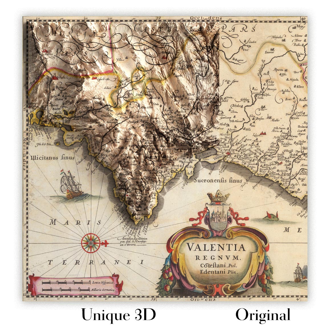
For something truly unique, this map is also available in "Unique 3D", our trademarked process that dramatically transforms the map so that it has a wonderful sense of depth. We combine the original map with detailed topography and elevation data, so that mountains and the terrain really "pop". For more info and examples of 3D maps, check my Unique 3D page.
Many of our maps and art prints are chosen as thoughtful gifts for homes, offices, studies and meaningful places.
Choose a framed option for the easiest ready-to-hang gift, or choose an unframed print if the recipient may prefer to select their own frame.
We make orders locally in 23 countries around the world, so gifts can often be produced close to the recipient. This helps them arrive faster, travel more safely, and avoid customs or import duty surprises.
- We can deliver directly to the recipient
- Framed pieces arrive ready to hang
- Unframed prints are carefully packed in a strong protective tube
- Almost every order is made locally, for faster, safer gifting
- 90-day returns give the recipient time to decide
If you are not sure what to choose, please contact us. We can help you pick the right map, size, finish or delivery option.
Most orders are made locally and delivered in around 2–3 working days, depending on the product, size and destination.
We print and frame maps and artwork in 23 countries around the world, so your order is usually made close to you or your recipient. That means faster delivery, less time in transit, and no customs or import duty surprises.
Personalised and customised pieces usually take an extra 1–2 working days, because we prepare your design and send it to you for approval before printing.
Very large framed orders can take a little longer, as they need extra care in production and delivery.
Every order is carefully packaged: unframed prints are sent in a strong protective tube, while framed pieces are securely packed with protective materials around the frame.
If you need your order by a particular date, please contact us before ordering. We’ll check the best production route and delivery option for your location.
Express delivery is available at checkout for most countries. Next-day delivery is available in the UK, US, Singapore and the UAE.
Your order is covered by our 90-day returns policy and 10-year guarantee.
Our standard frame is a gallery-style black ash hardwood frame, with a simple, modern look. It is approximately 20mm (0.8in) wide. You can also view some lovely customer photos of framed maps and art.
We use super-clear acrylic glazing, also known as Perspex or Acrylite, instead of traditional glass. It is lighter, safer, and has lower reflectivity, giving the artwork a clearer, cleaner appearance.
Six standard frame colours are available at no extra cost: black, dark brown, dark grey, oak, white, and antique gold. Custom framing and mounting/matting is also available for customers looking for something more specific.
Most maps, art prints, and illustrations are also available as a framed canvas. We use matte cotton canvas, stretch it over a sustainably sourced wooden box frame, and then float the piece within a wooden outer frame. The finished result is beautifully presented, with no glazing between you and the artwork.
All frames are supplied ready to hang, with either string or brackets fitted to the back. Very large frames will include heavy-duty hanging plates and/or a mounting baton. If you have any questions, please get in touch.
We can also supply old maps and artwork on canvas, foam board, cotton rag, and other materials.
If you would prefer to frame your map or artwork yourself, please read our size guide before ordering.
My maps are extremely high quality reproductions of original maps.
I source original, rare maps from libraries, auction houses and private collections around the world, restore them at my London workshop, and then use specialist giclée inks and printers to create beautiful maps that look even better than the original.
My maps are printed on acid-free archival matte (not glossy) paper that feels very high quality and almost like card. In technical terms the paper weight/thickness is 10mil/200gsm. It's perfect for framing.
I print with Epson ultrachrome giclée UV fade resistant pigment inks - some of the best inks you can find.
I can also make maps on canvas, cotton rag and other exotic materials.
Learn more about The Unique Maps Co.
Map personalisation
If you're looking for the perfect anniversary or housewarming gift, I can personalise your map to make it truly unique. For example, I can add a short message, or highlight an important location, or add your family's coat of arms.
The options are almost infinite. Please see my map personalisation page for some wonderful examples of what's possible.
To order a personalised map, select "personalise your map" before adding it to your basket.
Get in touch if you're looking for more complex customisations and personalisations.
Map ageing
I have been asked hundreds of times over the years by customers if they could buy a map that looks even older.
Well, now you can, by selecting Aged before you add a map to your basket.
All the product photos you see on this page show the map in its Original form. This is what the map looks like today.
If you select Aged, I will age your map by hand, using a special and unique process developed through years of studying old maps, talking to researchers to understand the chemistry of aging paper, and of course... lots of practice!
If you're unsure, stick to the Original colour of the map. If you want something a bit darker and older looking, go for Aged.
If you are not happy with your order for any reason, contact me and I'll get it fixed ASAP, free of charge. Please see my returns and refund policy for more information.
I am very confident you will like your restored map or art print. I have been doing this since 1984. I'm a 5-star Etsy seller. I have sold tens of thousands of maps and art prints and have over 5,000 real 5-star reviews. My work has been featured in interior design magazines, on the BBC, and on the walls of dozens of 5-star hotels.
I use a unique process to restore maps and artwork that is massively time consuming and labour intensive. Hunting down the original maps and illustrations can take months. I use state of the art and eye-wateringly expensive technology to scan and restore them. As a result, I guarantee my maps and art prints are a cut above the rest. I stand by my products and will always make sure you're 100% happy with what you receive.
Almost all of my maps and art prints look amazing at large sizes (200cm, 6.5ft+) and I can frame and deliver them to you as well, via special oversized courier. Contact me to discuss your specific needs.
Or try searching for something!


