


Rare Old Map of Eastern and Julian Alps by Mayr, 1874: Trieste, Slovenia, Croatia, Adriatic Sea
The Collector’s Offer
Choose two eligible works and receive 20% off both. Choose three and the lowest-priced one is complimentary, a maximum saving of 33%.
Mix and match eligible standard maps and fine-art prints. No code is required; the offer is applied automatically at checkout.
Standard made-to-order configurations are included. Bespoke sizes, personalised designs and commissioned work are excluded.
Need delivery to different addresses? Contact us before ordering.The Collector’s Offer
Choose two eligible works and receive 20% off both. Choose three and the lowest-priced one is complimentary, a maximum saving of 33%.
Mix and match eligible standard maps and fine-art prints. No code is required; the offer is applied automatically at checkout.
Standard made-to-order configurations are included. Bespoke sizes, personalised designs and commissioned work are excluded.
Need delivery to different addresses? Contact us before ordering. Designed in London Made in the EU
Designed in London • Made in the EU
Designed in London Made in the EU
Designed in London • Made in the EU

Restored from the original 1874 map and printed to museum-grade archival standards. Read the story behind this map
Choose your size
Choose your finish


(More info)
Gift message & custom finish

If you want to add a gift message, or a finish (jigsaw, aluminium board, etc.) that is not available here, please request it in the "order note" when you check out.
Every order is custom made, so if you need the size adjusted slightly, or printed on an unusual material, just let us know. We've done thousands of custom orders over the years, so there's (almost) nothing we can't manage.
You can also contact us before you order, if you prefer!

- Made locally for fast, safe delivery
- No import duty or hidden fees
- Need advice? Call us or message on WhatsApp
Own a piece of history
8,000+ five-star reviews


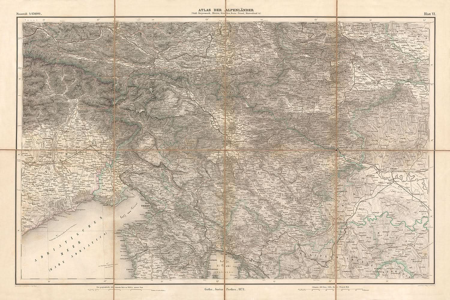
The "Atlas der Alpenländer. Blatt VI." is a captivating historical map crafted by the renowned cartographer Johann Georg Mayr in 1874. This...
Continue readingThe "Atlas der Alpenländer. Blatt VI." is a captivating historical map crafted by the renowned cartographer Johann Georg Mayr in 1874. This exquisite piece is part of an eleven-sheet topographic atlas that meticulously captures the majestic landscapes of the Alpine countries. Focusing on the region around Trieste, Italy, this map offers a window into the past, illustrating the intricate interplay of political and physical geography during the 19th century. Mayr's dedication to precision and artistry is evident in the detailed depiction of cities, railroads, and natural features, making this map a true collector's gem.
Johann Georg Mayr, a distinguished figure in the world of cartography, was celebrated for his ability to bring the complex terrains of the Alps to life. His work reflects the era's burgeoning interest in geographic exploration and the importance of the Alps as a pivotal European crossroads. Mayr's maps were not merely functional; they were works of art that combined scientific accuracy with aesthetic appeal, capturing the imagination of travelers and scholars alike.
The map's detailed representation of the Alpine region is a testament to Mayr's skillful use of hachures to convey the rugged terrain. The intricate outlines and hand-colored borders highlight the political boundaries of the time, offering insight into the historical context of the region. The inclusion of the Adriatic Sea, known as the Adriatisches Meer, adds a dramatic touch, emphasizing the strategic significance of coastal cities like Trieste.
This map serves as a fascinating historical document, capturing the essence of a time when the Alps were both a natural barrier and a conduit for cultural exchange. The depiction of railroads and drainage systems reflects the technological advancements of the period, while the careful placement of cities and towns provides a glimpse into the socio-economic landscape of the 19th century. It is a reminder of the enduring allure of the Alps and their role in shaping European history.
For collectors and enthusiasts of historical cartography, this map is more than just a decorative piece; it is a narrative of exploration and discovery. The artistry and precision of Johann Georg Mayr's work invite viewers to embark on a journey through time, exploring the rich tapestry of landscapes and cultures that define the Alpine region. This map is a celebration of the enduring legacy of cartography and its power to illuminate the past.
Cities and towns on this map
- Italy
- Trieste
Notable Features & Landmarks
- Bodies of water:
- Adriatic Sea (Adriatisches Meer)
- Mountains:
- Depicted using hachures, representing the Alpine region.
- Borders:
- Political boundaries are outlined by hand coloring.
Historical and design context
- Creation date: 1874
- Mapmaker/Publisher: Johann Georg Mayr
- Part of an eleven-sheet topographic atlas focusing on the Alps.
- Includes political and physical features such as cities, railroads, topography, lakes, and drainage.
- Black and white engraving with hand-colored outlines.
- Represents 19th-century cartographic techniques and the importance of the Alps in European geography and travel.
Please double check the images to make sure that a specific town or place is shown on this map. You can also get in touch and ask us to check the map for you.
This map looks great at every size, but I always recommend going for a larger size if you have space. That way you can easily make out all of the details.
This map looks amazing at sizes all the way up to 100in (250cm). If you are looking for a larger map, please get in touch.
Please note: the labels on this map are hard to read if you order a map that is 16in (40cm) or smaller. The map is still very attractive, but if you would like to read the map easily, please buy a larger size.
The model in the listing images is holding the 24x36in (60x90cm) version of this map.
The fifth listing image shows an example of my map personalisation service.
If you’re looking for something slightly different, check out my collection of the best old maps to see if something else catches your eye.
Please contact me to check if a certain location, landmark or feature is shown on this map.
This would make a wonderful birthday, Christmas, Father's Day, work leaving, anniversary or housewarming gift for someone from the areas covered by this map.
This map is available as a giclée print on acid free archival matte paper, or you can buy it framed. The frame is a nice, simple black frame that suits most aesthetics. Please get in touch if you'd like a different frame colour or material. My frames are glazed with super-clear museum-grade acrylic (perspex/acrylite), which is significantly less reflective than glass, safer, and will always arrive in perfect condition.
This map is also available as a float framed canvas, sometimes known as a shadow gap framed canvas or canvas floater. The map is printed on artist's cotton canvas and then stretched over a handmade box frame. We then "float" the canvas inside a wooden frame, which is available in a range of colours (black, dark brown, oak, antique gold and white). This is a wonderful way to present a map without glazing in front. See some examples of float framed canvas maps and explore the differences between my different finishes.
For something truly unique, this map is also available in "Unique 3D", our trademarked process that dramatically transforms the map so that it has a wonderful sense of depth. We combine the original map with detailed topography and elevation data, so that mountains and the terrain really "pop". For more info and examples of 3D maps, check my Unique 3D page.
The "Atlas der Alpenländer. Blatt VI." is a captivating historical map crafted by the renowned cartographer Johann Georg Mayr in 1874. This exquisite piece is part of an eleven-sheet topographic atlas that meticulously captures the majestic landscapes of the Alpine countries. Focusing on the region around Trieste, Italy, this map offers a window into the past, illustrating the intricate interplay of political and physical geography during the 19th century. Mayr's dedication to precision and artistry is evident in the detailed depiction of cities, railroads, and natural features, making this map a true collector's gem.
Johann Georg Mayr, a distinguished figure in the world of cartography, was celebrated for his ability to bring the complex terrains of the Alps to life. His work reflects the era's burgeoning interest in geographic exploration and the importance of the Alps as a pivotal European crossroads. Mayr's maps were not merely functional; they were works of art that combined scientific accuracy with aesthetic appeal, capturing the imagination of travelers and scholars alike.
The map's detailed representation of the Alpine region is a testament to Mayr's skillful use of hachures to convey the rugged terrain. The intricate outlines and hand-colored borders highlight the political boundaries of the time, offering insight into the historical context of the region. The inclusion of the Adriatic Sea, known as the Adriatisches Meer, adds a dramatic touch, emphasizing the strategic significance of coastal cities like Trieste.
This map serves as a fascinating historical document, capturing the essence of a time when the Alps were both a natural barrier and a conduit for cultural exchange. The depiction of railroads and drainage systems reflects the technological advancements of the period, while the careful placement of cities and towns provides a glimpse into the socio-economic landscape of the 19th century. It is a reminder of the enduring allure of the Alps and their role in shaping European history.
For collectors and enthusiasts of historical cartography, this map is more than just a decorative piece; it is a narrative of exploration and discovery. The artistry and precision of Johann Georg Mayr's work invite viewers to embark on a journey through time, exploring the rich tapestry of landscapes and cultures that define the Alpine region. This map is a celebration of the enduring legacy of cartography and its power to illuminate the past.
Cities and towns on this map
- Italy
- Trieste
Notable Features & Landmarks
- Bodies of water:
- Adriatic Sea (Adriatisches Meer)
- Mountains:
- Depicted using hachures, representing the Alpine region.
- Borders:
- Political boundaries are outlined by hand coloring.
Historical and design context
- Creation date: 1874
- Mapmaker/Publisher: Johann Georg Mayr
- Part of an eleven-sheet topographic atlas focusing on the Alps.
- Includes political and physical features such as cities, railroads, topography, lakes, and drainage.
- Black and white engraving with hand-colored outlines.
- Represents 19th-century cartographic techniques and the importance of the Alps in European geography and travel.
Please double check the images to make sure that a specific town or place is shown on this map. You can also get in touch and ask us to check the map for you.
This map looks great at every size, but I always recommend going for a larger size if you have space. That way you can easily make out all of the details.
This map looks amazing at sizes all the way up to 100in (250cm). If you are looking for a larger map, please get in touch.
Please note: the labels on this map are hard to read if you order a map that is 16in (40cm) or smaller. The map is still very attractive, but if you would like to read the map easily, please buy a larger size.
The model in the listing images is holding the 24x36in (60x90cm) version of this map.
The fifth listing image shows an example of my map personalisation service.
If you’re looking for something slightly different, check out my collection of the best old maps to see if something else catches your eye.
Please contact me to check if a certain location, landmark or feature is shown on this map.
This would make a wonderful birthday, Christmas, Father's Day, work leaving, anniversary or housewarming gift for someone from the areas covered by this map.
This map is available as a giclée print on acid free archival matte paper, or you can buy it framed. The frame is a nice, simple black frame that suits most aesthetics. Please get in touch if you'd like a different frame colour or material. My frames are glazed with super-clear museum-grade acrylic (perspex/acrylite), which is significantly less reflective than glass, safer, and will always arrive in perfect condition.
This map is also available as a float framed canvas, sometimes known as a shadow gap framed canvas or canvas floater. The map is printed on artist's cotton canvas and then stretched over a handmade box frame. We then "float" the canvas inside a wooden frame, which is available in a range of colours (black, dark brown, oak, antique gold and white). This is a wonderful way to present a map without glazing in front. See some examples of float framed canvas maps and explore the differences between my different finishes.
For something truly unique, this map is also available in "Unique 3D", our trademarked process that dramatically transforms the map so that it has a wonderful sense of depth. We combine the original map with detailed topography and elevation data, so that mountains and the terrain really "pop". For more info and examples of 3D maps, check my Unique 3D page.
Many of our maps and art prints are chosen as thoughtful gifts for homes, offices, studies and meaningful places.
Choose a framed option for the easiest ready-to-hang gift, or choose an unframed print if the recipient may prefer to select their own frame.
We make orders locally in 23 countries around the world, so gifts can often be produced close to the recipient. This helps them arrive faster, travel more safely, and avoid customs or import duty surprises.
- We can deliver directly to the recipient
- Framed pieces arrive ready to hang
- Unframed prints are carefully packed in a strong protective tube
- Almost every order is made locally, for faster, safer gifting
- 90-day returns give the recipient time to decide
If you are not sure what to choose, please contact us. We can help you pick the right map, size, finish or delivery option.
Most orders are made locally and delivered in around 2–3 working days, depending on the product, size and destination.
We print and frame maps and artwork in 23 countries around the world, so your order is usually made close to you or your recipient. That means faster delivery, less time in transit, and no customs or import duty surprises.
Personalised and customised pieces usually take an extra 1–2 working days, because we prepare your design and send it to you for approval before printing.
Very large framed orders can take a little longer, as they need extra care in production and delivery.
Every order is carefully packaged: unframed prints are sent in a strong protective tube, while framed pieces are securely packed with protective materials around the frame.
If you need your order by a particular date, please contact us before ordering. We’ll check the best production route and delivery option for your location.
Express delivery is available at checkout for most countries. Next-day delivery is available in the UK, US, Singapore and the UAE.
Your order is covered by our 90-day returns policy and 10-year guarantee.
Our standard frame is a gallery-style black ash hardwood frame, with a simple, modern look. It is approximately 20mm (0.8in) wide. You can also view some lovely customer photos of framed maps and art.
We use super-clear acrylic glazing, also known as Perspex or Acrylite, instead of traditional glass. It is lighter, safer, and has lower reflectivity, giving the artwork a clearer, cleaner appearance.
Six standard frame colours are available at no extra cost: black, dark brown, dark grey, oak, white, and antique gold. Custom framing and mounting/matting is also available for customers looking for something more specific.
Most maps, art prints, and illustrations are also available as a framed canvas. We use matte cotton canvas, stretch it over a sustainably sourced wooden box frame, and then float the piece within a wooden outer frame. The finished result is beautifully presented, with no glazing between you and the artwork.
All frames are supplied ready to hang, with either string or brackets fitted to the back. Very large frames will include heavy-duty hanging plates and/or a mounting baton. If you have any questions, please get in touch.
We can also supply old maps and artwork on canvas, foam board, cotton rag, and other materials.
If you would prefer to frame your map or artwork yourself, please read our size guide before ordering.
My maps are extremely high quality reproductions of original maps.
I source original, rare maps from libraries, auction houses and private collections around the world, restore them at my London workshop, and then use specialist giclée inks and printers to create beautiful maps that look even better than the original.
My maps are printed on acid-free archival matte (not glossy) paper that feels very high quality and almost like card. In technical terms the paper weight/thickness is 10mil/200gsm. It's perfect for framing.
I print with Epson ultrachrome giclée UV fade resistant pigment inks - some of the best inks you can find.
I can also make maps on canvas, cotton rag and other exotic materials.
Learn more about The Unique Maps Co.
Map personalisation
If you're looking for the perfect anniversary or housewarming gift, I can personalise your map to make it truly unique. For example, I can add a short message, or highlight an important location, or add your family's coat of arms.
The options are almost infinite. Please see my map personalisation page for some wonderful examples of what's possible.
To order a personalised map, select "personalise your map" before adding it to your basket.
Get in touch if you're looking for more complex customisations and personalisations.
Map ageing
I have been asked hundreds of times over the years by customers if they could buy a map that looks even older.
Well, now you can, by selecting Aged before you add a map to your basket.
All the product photos you see on this page show the map in its Original form. This is what the map looks like today.
If you select Aged, I will age your map by hand, using a special and unique process developed through years of studying old maps, talking to researchers to understand the chemistry of aging paper, and of course... lots of practice!
If you're unsure, stick to the Original colour of the map. If you want something a bit darker and older looking, go for Aged.
If you are not happy with your order for any reason, contact me and I'll get it fixed ASAP, free of charge. Please see my returns and refund policy for more information.
I am very confident you will like your restored map or art print. I have been doing this since 1984. I'm a 5-star Etsy seller. I have sold tens of thousands of maps and art prints and have over 5,000 real 5-star reviews. My work has been featured in interior design magazines, on the BBC, and on the walls of dozens of 5-star hotels.
I use a unique process to restore maps and artwork that is massively time consuming and labour intensive. Hunting down the original maps and illustrations can take months. I use state of the art and eye-wateringly expensive technology to scan and restore them. As a result, I guarantee my maps and art prints are a cut above the rest. I stand by my products and will always make sure you're 100% happy with what you receive.
Almost all of my maps and art prints look amazing at large sizes (200cm, 6.5ft+) and I can frame and deliver them to you as well, via special oversized courier. Contact me to discuss your specific needs.
Or try searching for something!


