


Rare Old Map of Dutch East Indies Airplane Routes by Wijga, 1935: Art Deco, Airline Routes, Cultural Illustrations
20% off 2 — 33% off 3
Add any two eligible items to your bag to receive 20% off. Add a third and it will be complimentary (equivalent to 33% off when purchasing three).
No code needed — the offer applies automatically at checkout.
Valid on all standard maps and fine art prints. You can mix and match any designs.
If you’d like to ship items to multiple addresses, please contact us before placing your order.
Custom and bespoke commissions are excluded.
Contact us if you have any questions
 Designed in London Made in the EU
Designed in London • Made in the EU
Designed in London Made in the EU
Designed in London • Made in the EU

Restored from the original 1935 map and printed to museum-grade archival standards. Read the story behind this map
Choose your size
Choose your finish


(More info)
Gift message & custom finish

If you want to add a gift message, or a finish (jigsaw, aluminium board, etc.) that is not available here, please request it in the "order note" when you check out.
Every order is custom made, so if you need the size adjusted slightly, or printed on an unusual material, just let us know. We've done thousands of custom orders over the years, so there's (almost) nothing we can't manage.
You can also contact us before you order, if you prefer!

- Made locally for fast, safe delivery
- No import duty or hidden fees
- Need advice? Call us or message on WhatsApp
Own a piece of history
8,000+ five-star reviews


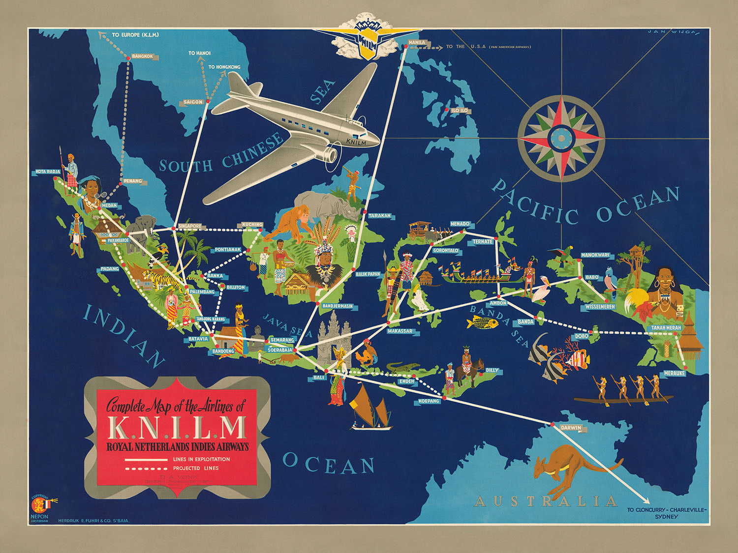
Immerse yourself in the rich history and vibrant culture of Southeast Asia with this exquisite 1935 art deco map, meticulously crafted by...
Continue readingImmerse yourself in the rich history and vibrant culture of Southeast Asia with this exquisite 1935 art deco map, meticulously crafted by renowned Dutch commercial artist Jan Wijga. This map, titled "Complete Map of the Airlines of K.N.I.L.M., Royal Netherlands Indies Airways," offers a fascinating glimpse into the early days of aviation in the Dutch East Indies, now modern-day Indonesia. Highlighting the extensive airline routes of K.N.I.L.M., the Royal Netherlands Indies Airways, this map captures the essence of a bygone era where air travel was a burgeoning industry, connecting distant lands and diverse cultures.
The map's thematic focus on airline routes is both informative and visually captivating. Solid lines represent the existing routes, while dotted lines illustrate the ambitious proposed routes, including amphibious routes to the rural eastern islands of the archipelago. The Lockheed Model 14 Super Electra, a star of the K.N.I.L.M. fleet, is prominently featured, symbolizing the technological advancements and aspirations of the era. This map is not just a navigational tool but a testament to the pioneering spirit of early 20th-century aviation.
Wijga's art deco style brings the map to life with vivid coloration and intricate vignette illustrations of indigenous people, architecture, and wildlife. The Dutch East Indies are highlighted with bold colors, making the region stand out amidst the surrounding seas and lands. The map also features a stylized compass rose in the Pacific Ocean, adding a touch of elegance and aiding in navigation. Each illustration tells a story, offering a visual journey through the diverse cultures and natural beauty of the region.
Beyond its aesthetic appeal, this map holds significant historical value. It reflects the Dutch colonial influence in Southeast Asia during the 1930s and the strategic importance of the region in global aviation. The routes connecting to Europe via KLM and to the USA via Pan American Airways underscore the interconnectedness of the world even in the early days of commercial aviation. This map is a window into the past, showcasing the development of air travel routes that were instrumental in shaping modern-day transportation networks.
Owning this map is like holding a piece of history in your hands. It is a perfect addition for collectors, history enthusiasts, or anyone with a passion for cartography and aviation. The map not only serves as a beautiful decorative piece but also as an educational tool, offering insights into the cultural, technological, and geopolitical landscape of the 1930s. Jan Wijga's masterful craftsmanship and the map's rich historical context make it a truly unique and valuable artifact.
Places on this map
- Countries and regions:
- Bangkok
- Darwin, Australia
- Sumatra
- New Guinea
- Dutch East Indies (modern-day Indonesia)
- Cities and towns:
- Bangkok
- Hong Kong
- Saigon
- Singapore
- Medan
- Penang
- Batavia (Jakarta)
- Bandung
- Semarang
- Surabaya
- Makassar
- Bali
- Kupang
- Dili
- Manila
- Iloilo
- Manokwari
- Babo
- Wisselmeren
- Tanah Merah
- Darwin
- Seas and oceans:
- South Chinese Sea
- Java Sea
- Indian Ocean
- Pacific Ocean
- Banda Sea
- Islands:
- Various islands of the East India archipelago
- Geographical features:
- Mountains
- Rivers
- Forests
Notable Features & Landmarks
- Airline routes:
- Solid lines: Represent existing routes.
- Dotted lines: Represent proposed routes.
- Illustrations:
- Indigenous people: Depicted in traditional attire.
- Architecture: Various buildings and structures from the region.
- Wildlife: Animals native to the region.
- Airplane: Lockheed Model 14 Super Electra.
- Compass rose: Stylized and colorful, located in the Pacific Ocean.
- Geographical features:
- Seas: South Chinese Sea, Java Sea, Indian Ocean, Pacific Ocean, Banda Sea.
- Islands: Various islands of the East India archipelago.
- Cities and towns: Names of cities and towns along the airline routes.
- Routes to other regions:
- To Europe: Via KLM.
- To the USA: Via Pan American Airways.
- Artistic elements:
- Vivid coloration: Highlights the Dutch East Indies.
- Vignette illustrations: Add cultural and natural context.
- Historical context:
- Dutch colonial influence: Reflected in the map's focus and design.
- Aviation development: Early 20th-century air travel routes.
- Cultural depictions: Traditional clothing, dances, and local practices.
Historical and design context
- Name of the map: Complete Map of the Airlines of K.N.I.L.M., Royal Netherlands Indies Airways
- Creation date: 1935
- Mapmaker: Jan Wijga
- Context about the mapmaker: Jan Wijga was a Dutch commercial artist known for his art deco style.
- Themes and topics:
- Infographic thematic map: The map is a visual representation of the airline routes of K.N.I.L.M.
- Art Deco style: The map features vivid colors and vignette illustrations typical of the art deco period.
- Airline routes: Solid lines indicate existing routes, while dotted lines represent proposed routes.
- Illustrations: The map includes depictions of indigenous people, architecture, and wildlife of the Dutch East Indies.
- Airplane: The Lockheed Model 14 Super Electra, a prominent aircraft in the K.N.I.L.M. fleet, is illustrated.
- Regions shown:
- East India archipelago
- Southeast Asia: Includes areas from Bangkok to Darwin, Australia, and from Sumatra to New Guinea.
- Modern-day Indonesia: Highlighted with vivid coloration.
- Design and style:
- Art Deco: The map's design is characterized by bold colors and stylized illustrations.
- Infographic: Conveys information about the airline routes in an illustrative manner.
- Historical significance:
- K.N.I.L.M. (Royal Netherlands Indies Airways): The airline operated from 1928 to 1942, serving the Dutch East Indies.
- Dutch colonial era: The map reflects the colonial presence and infrastructure in Southeast Asia during the 1930s.
- Aviation history: Highlights the development of air travel routes in the region during the early 20th century.
Please double check the images to make sure that a specific town or place is shown on this map. You can also get in touch and ask us to check the map for you.
This map looks great at every size, but I always recommend going for a larger size if you have space. That way you can easily make out all of the details.
This map looks amazing at sizes all the way up to 100in (250cm). If you are looking for a larger map, please get in touch.
The model in the listing images is holding the 18x24in (45x60cm) version of this map.
The fifth listing image shows an example of my map personalisation service.
If you’re looking for something slightly different, check out my collection of the best old maps to see if something else catches your eye.
Please contact me to check if a certain location, landmark or feature is shown on this map.
This would make a wonderful birthday, Christmas, Father's Day, work leaving, anniversary or housewarming gift for someone from the areas covered by this map.
This map is available as a giclée print on acid free archival matte paper, or you can buy it framed. The frame is a nice, simple black frame that suits most aesthetics. Please get in touch if you'd like a different frame colour or material. My frames are glazed with super-clear museum-grade acrylic (perspex/acrylite), which is significantly less reflective than glass, safer, and will always arrive in perfect condition.
This map is also available as a float framed canvas, sometimes known as a shadow gap framed canvas or canvas floater. The map is printed on artist's cotton canvas and then stretched over a handmade box frame. We then "float" the canvas inside a wooden frame, which is available in a range of colours (black, dark brown, oak, antique gold and white). This is a wonderful way to present a map without glazing in front. See some examples of float framed canvas maps and explore the differences between my different finishes.
For something truly unique, this map is also available in "Unique 3D", our trademarked process that dramatically transforms the map so that it has a wonderful sense of depth. We combine the original map with detailed topography and elevation data, so that mountains and the terrain really "pop". For more info and examples of 3D maps, check my Unique 3D page.
Immerse yourself in the rich history and vibrant culture of Southeast Asia with this exquisite 1935 art deco map, meticulously crafted by renowned Dutch commercial artist Jan Wijga. This map, titled "Complete Map of the Airlines of K.N.I.L.M., Royal Netherlands Indies Airways," offers a fascinating glimpse into the early days of aviation in the Dutch East Indies, now modern-day Indonesia. Highlighting the extensive airline routes of K.N.I.L.M., the Royal Netherlands Indies Airways, this map captures the essence of a bygone era where air travel was a burgeoning industry, connecting distant lands and diverse cultures.
The map's thematic focus on airline routes is both informative and visually captivating. Solid lines represent the existing routes, while dotted lines illustrate the ambitious proposed routes, including amphibious routes to the rural eastern islands of the archipelago. The Lockheed Model 14 Super Electra, a star of the K.N.I.L.M. fleet, is prominently featured, symbolizing the technological advancements and aspirations of the era. This map is not just a navigational tool but a testament to the pioneering spirit of early 20th-century aviation.
Wijga's art deco style brings the map to life with vivid coloration and intricate vignette illustrations of indigenous people, architecture, and wildlife. The Dutch East Indies are highlighted with bold colors, making the region stand out amidst the surrounding seas and lands. The map also features a stylized compass rose in the Pacific Ocean, adding a touch of elegance and aiding in navigation. Each illustration tells a story, offering a visual journey through the diverse cultures and natural beauty of the region.
Beyond its aesthetic appeal, this map holds significant historical value. It reflects the Dutch colonial influence in Southeast Asia during the 1930s and the strategic importance of the region in global aviation. The routes connecting to Europe via KLM and to the USA via Pan American Airways underscore the interconnectedness of the world even in the early days of commercial aviation. This map is a window into the past, showcasing the development of air travel routes that were instrumental in shaping modern-day transportation networks.
Owning this map is like holding a piece of history in your hands. It is a perfect addition for collectors, history enthusiasts, or anyone with a passion for cartography and aviation. The map not only serves as a beautiful decorative piece but also as an educational tool, offering insights into the cultural, technological, and geopolitical landscape of the 1930s. Jan Wijga's masterful craftsmanship and the map's rich historical context make it a truly unique and valuable artifact.
Places on this map
- Countries and regions:
- Bangkok
- Darwin, Australia
- Sumatra
- New Guinea
- Dutch East Indies (modern-day Indonesia)
- Cities and towns:
- Bangkok
- Hong Kong
- Saigon
- Singapore
- Medan
- Penang
- Batavia (Jakarta)
- Bandung
- Semarang
- Surabaya
- Makassar
- Bali
- Kupang
- Dili
- Manila
- Iloilo
- Manokwari
- Babo
- Wisselmeren
- Tanah Merah
- Darwin
- Seas and oceans:
- South Chinese Sea
- Java Sea
- Indian Ocean
- Pacific Ocean
- Banda Sea
- Islands:
- Various islands of the East India archipelago
- Geographical features:
- Mountains
- Rivers
- Forests
Notable Features & Landmarks
- Airline routes:
- Solid lines: Represent existing routes.
- Dotted lines: Represent proposed routes.
- Illustrations:
- Indigenous people: Depicted in traditional attire.
- Architecture: Various buildings and structures from the region.
- Wildlife: Animals native to the region.
- Airplane: Lockheed Model 14 Super Electra.
- Compass rose: Stylized and colorful, located in the Pacific Ocean.
- Geographical features:
- Seas: South Chinese Sea, Java Sea, Indian Ocean, Pacific Ocean, Banda Sea.
- Islands: Various islands of the East India archipelago.
- Cities and towns: Names of cities and towns along the airline routes.
- Routes to other regions:
- To Europe: Via KLM.
- To the USA: Via Pan American Airways.
- Artistic elements:
- Vivid coloration: Highlights the Dutch East Indies.
- Vignette illustrations: Add cultural and natural context.
- Historical context:
- Dutch colonial influence: Reflected in the map's focus and design.
- Aviation development: Early 20th-century air travel routes.
- Cultural depictions: Traditional clothing, dances, and local practices.
Historical and design context
- Name of the map: Complete Map of the Airlines of K.N.I.L.M., Royal Netherlands Indies Airways
- Creation date: 1935
- Mapmaker: Jan Wijga
- Context about the mapmaker: Jan Wijga was a Dutch commercial artist known for his art deco style.
- Themes and topics:
- Infographic thematic map: The map is a visual representation of the airline routes of K.N.I.L.M.
- Art Deco style: The map features vivid colors and vignette illustrations typical of the art deco period.
- Airline routes: Solid lines indicate existing routes, while dotted lines represent proposed routes.
- Illustrations: The map includes depictions of indigenous people, architecture, and wildlife of the Dutch East Indies.
- Airplane: The Lockheed Model 14 Super Electra, a prominent aircraft in the K.N.I.L.M. fleet, is illustrated.
- Regions shown:
- East India archipelago
- Southeast Asia: Includes areas from Bangkok to Darwin, Australia, and from Sumatra to New Guinea.
- Modern-day Indonesia: Highlighted with vivid coloration.
- Design and style:
- Art Deco: The map's design is characterized by bold colors and stylized illustrations.
- Infographic: Conveys information about the airline routes in an illustrative manner.
- Historical significance:
- K.N.I.L.M. (Royal Netherlands Indies Airways): The airline operated from 1928 to 1942, serving the Dutch East Indies.
- Dutch colonial era: The map reflects the colonial presence and infrastructure in Southeast Asia during the 1930s.
- Aviation history: Highlights the development of air travel routes in the region during the early 20th century.
Please double check the images to make sure that a specific town or place is shown on this map. You can also get in touch and ask us to check the map for you.
This map looks great at every size, but I always recommend going for a larger size if you have space. That way you can easily make out all of the details.
This map looks amazing at sizes all the way up to 100in (250cm). If you are looking for a larger map, please get in touch.
The model in the listing images is holding the 18x24in (45x60cm) version of this map.
The fifth listing image shows an example of my map personalisation service.
If you’re looking for something slightly different, check out my collection of the best old maps to see if something else catches your eye.
Please contact me to check if a certain location, landmark or feature is shown on this map.
This would make a wonderful birthday, Christmas, Father's Day, work leaving, anniversary or housewarming gift for someone from the areas covered by this map.
This map is available as a giclée print on acid free archival matte paper, or you can buy it framed. The frame is a nice, simple black frame that suits most aesthetics. Please get in touch if you'd like a different frame colour or material. My frames are glazed with super-clear museum-grade acrylic (perspex/acrylite), which is significantly less reflective than glass, safer, and will always arrive in perfect condition.
This map is also available as a float framed canvas, sometimes known as a shadow gap framed canvas or canvas floater. The map is printed on artist's cotton canvas and then stretched over a handmade box frame. We then "float" the canvas inside a wooden frame, which is available in a range of colours (black, dark brown, oak, antique gold and white). This is a wonderful way to present a map without glazing in front. See some examples of float framed canvas maps and explore the differences between my different finishes.
For something truly unique, this map is also available in "Unique 3D", our trademarked process that dramatically transforms the map so that it has a wonderful sense of depth. We combine the original map with detailed topography and elevation data, so that mountains and the terrain really "pop". For more info and examples of 3D maps, check my Unique 3D page.
Many of our maps and art prints are chosen as thoughtful gifts for homes, offices, studies and meaningful places.
Choose a framed option for the easiest ready-to-hang gift, or choose an unframed print if the recipient may prefer to select their own frame.
We make orders locally in 23 countries around the world, so gifts can often be produced close to the recipient. This helps them arrive faster, travel more safely, and avoid customs or import duty surprises.
- We can deliver directly to the recipient
- Framed pieces arrive ready to hang
- Unframed prints are carefully packed in a strong protective tube
- Almost every order is made locally, for faster, safer gifting
- 90-day returns give the recipient time to decide
If you are not sure what to choose, please contact us. We can help you pick the right map, size, finish or delivery option.
Most orders are made locally and delivered in around 2–3 working days, depending on the product, size and destination.
We print and frame maps and artwork in 23 countries around the world, so your order is usually made close to you or your recipient. That means faster delivery, less time in transit, and no customs or import duty surprises.
Personalised and customised pieces usually take an extra 1–2 working days, because we prepare your design and send it to you for approval before printing.
Very large framed orders can take a little longer, as they need extra care in production and delivery.
Every order is carefully packaged: unframed prints are sent in a strong protective tube, while framed pieces are securely packed with protective materials around the frame.
If you need your order by a particular date, please contact us before ordering. We’ll check the best production route and delivery option for your location.
Express delivery is available at checkout for most countries. Next-day delivery is available in the UK, US, Singapore and the UAE.
Your order is covered by our 90-day returns policy and 10-year guarantee.
Our standard frame is a gallery-style black ash hardwood frame, with a simple, modern look. It is approximately 20mm (0.8in) wide. You can also view some lovely customer photos of framed maps and art.
We use super-clear acrylic glazing, also known as Perspex or Acrylite, instead of traditional glass. It is lighter, safer, and has lower reflectivity, giving the artwork a clearer, cleaner appearance.
Six standard frame colours are available at no extra cost: black, dark brown, dark grey, oak, white, and antique gold. Custom framing and mounting/matting is also available for customers looking for something more specific.
Most maps, art prints, and illustrations are also available as a framed canvas. We use matte cotton canvas, stretch it over a sustainably sourced wooden box frame, and then float the piece within a wooden outer frame. The finished result is beautifully presented, with no glazing between you and the artwork.
All frames are supplied ready to hang, with either string or brackets fitted to the back. Very large frames will include heavy-duty hanging plates and/or a mounting baton. If you have any questions, please get in touch.
We can also supply old maps and artwork on canvas, foam board, cotton rag, and other materials.
If you would prefer to frame your map or artwork yourself, please read our size guide before ordering.
My maps are extremely high quality reproductions of original maps.
I source original, rare maps from libraries, auction houses and private collections around the world, restore them at my London workshop, and then use specialist giclée inks and printers to create beautiful maps that look even better than the original.
My maps are printed on acid-free archival matte (not glossy) paper that feels very high quality and almost like card. In technical terms the paper weight/thickness is 10mil/200gsm. It's perfect for framing.
I print with Epson ultrachrome giclée UV fade resistant pigment inks - some of the best inks you can find.
I can also make maps on canvas, cotton rag and other exotic materials.
Learn more about The Unique Maps Co.
Map personalisation
If you're looking for the perfect anniversary or housewarming gift, I can personalise your map to make it truly unique. For example, I can add a short message, or highlight an important location, or add your family's coat of arms.
The options are almost infinite. Please see my map personalisation page for some wonderful examples of what's possible.
To order a personalised map, select "personalise your map" before adding it to your basket.
Get in touch if you're looking for more complex customisations and personalisations.
Map ageing
I have been asked hundreds of times over the years by customers if they could buy a map that looks even older.
Well, now you can, by selecting Aged before you add a map to your basket.
All the product photos you see on this page show the map in its Original form. This is what the map looks like today.
If you select Aged, I will age your map by hand, using a special and unique process developed through years of studying old maps, talking to researchers to understand the chemistry of aging paper, and of course... lots of practice!
If you're unsure, stick to the Original colour of the map. If you want something a bit darker and older looking, go for Aged.
If you are not happy with your order for any reason, contact me and I'll get it fixed ASAP, free of charge. Please see my returns and refund policy for more information.
I am very confident you will like your restored map or art print. I have been doing this since 1984. I'm a 5-star Etsy seller. I have sold tens of thousands of maps and art prints and have over 5,000 real 5-star reviews. My work has been featured in interior design magazines, on the BBC, and on the walls of dozens of 5-star hotels.
I use a unique process to restore maps and artwork that is massively time consuming and labour intensive. Hunting down the original maps and illustrations can take months. I use state of the art and eye-wateringly expensive technology to scan and restore them. As a result, I guarantee my maps and art prints are a cut above the rest. I stand by my products and will always make sure you're 100% happy with what you receive.
Almost all of my maps and art prints look amazing at large sizes (200cm, 6.5ft+) and I can frame and deliver them to you as well, via special oversized courier. Contact me to discuss your specific needs.
Or try searching for something!


