


Rare Old Map of Chestnut & Chinquapin Tree Distribution in the USA, 1884
The Collector’s Offer
Choose two eligible works and receive 20% off both. Choose three and the lowest-priced one is complimentary, a maximum saving of 33%.
Mix and match eligible standard maps and fine-art prints. No code is required; the offer is applied automatically at checkout.
Standard made-to-order configurations are included. Bespoke sizes, personalised designs and commissioned work are excluded.
Need delivery to different addresses? Contact us before ordering.The Collector’s Offer
Choose two eligible works and receive 20% off both. Choose three and the lowest-priced one is complimentary, a maximum saving of 33%.
Mix and match eligible standard maps and fine-art prints. No code is required; the offer is applied automatically at checkout.
Standard made-to-order configurations are included. Bespoke sizes, personalised designs and commissioned work are excluded.
Need delivery to different addresses? Contact us before ordering. Designed in London Made in the EU
Designed in London • Made in the EU
Designed in London Made in the EU
Designed in London • Made in the EU

Restored from the original 1884 map and printed to museum-grade archival standards. Read the story behind this map
Choose your size
Choose your finish


(More info)
Gift message & custom finish

If you want to add a gift message, or a finish (jigsaw, aluminium board, etc.) that is not available here, please request it in the "order note" when you check out.
Every order is custom made, so if you need the size adjusted slightly, or printed on an unusual material, just let us know. We've done thousands of custom orders over the years, so there's (almost) nothing we can't manage.
You can also contact us before you order, if you prefer!

- Made locally for fast, safe delivery
- No import duty or hidden fees
- Need advice? Call us or message on WhatsApp
Own a piece of history
8,000+ five-star reviews


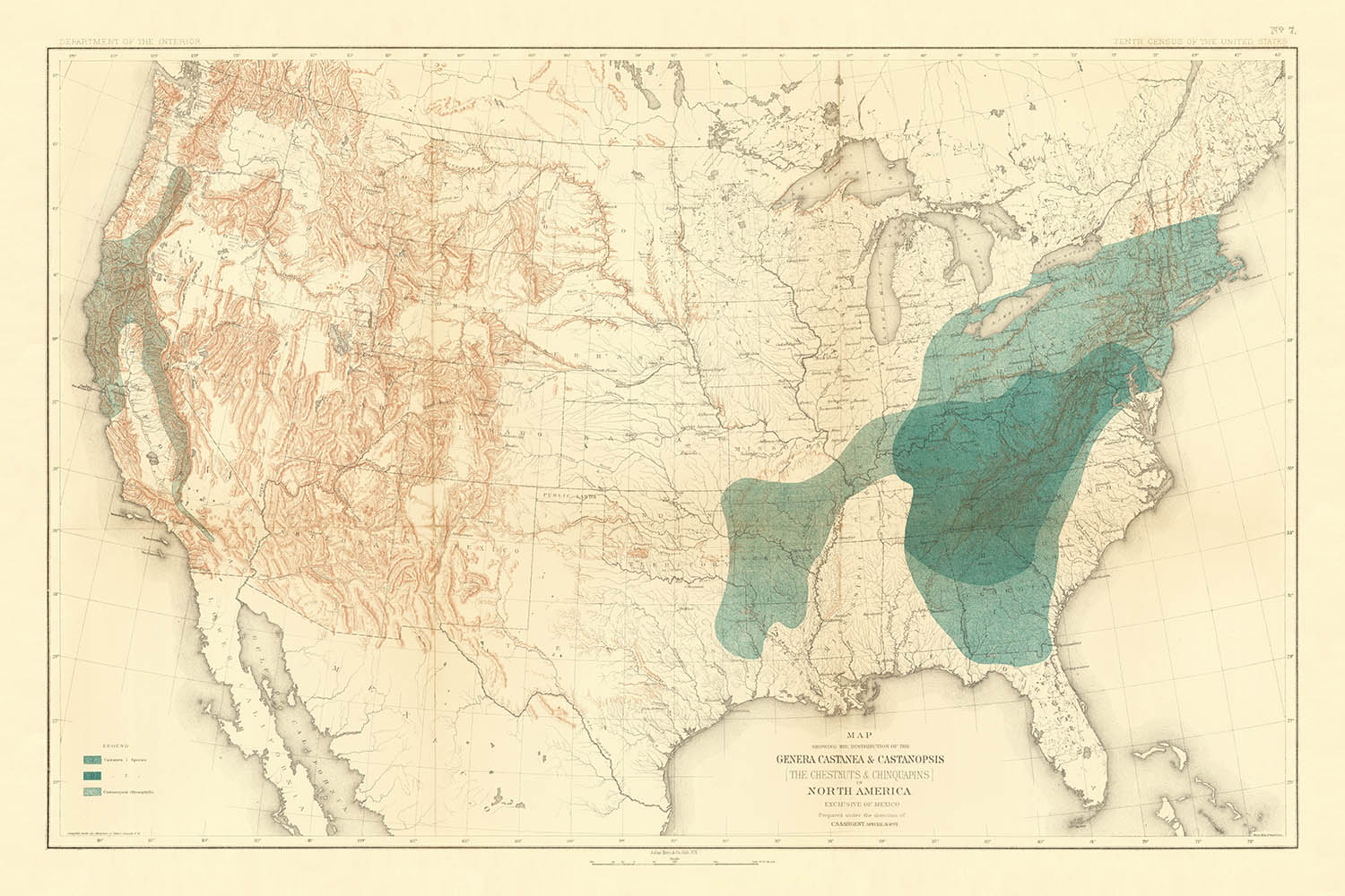
Step into the rich tapestry of North American botanical history with the "Map Showing the Distribution of the Genera Castanea & Castanopsis...
Continue readingStep into the rich tapestry of North American botanical history with the "Map Showing the Distribution of the Genera Castanea & Castanopsis (The Chestnuts & Chinquapins) in North America Exclusive of Mexico," a masterwork prepared under the direction of C.S. Sargent for the Tenth Census of the United States in 1884. This remarkable thematic map is more than a scientific document—it is a vivid snapshot of a landscape before the devastation of the American chestnut, capturing the native range of chestnuts and chinquapins at a pivotal moment in ecological history. The map’s careful delineation of these genera’s habitats reveals the profound relationship between geography and the continent’s once-abundant hardwood forests.
Produced by the renowned Julius Bien & Co., this map is a testament to the era’s finest color-lithographic techniques. Julius Bien, a luminary in American cartography and lithography, brought scientific precision and artistic elegance to every project. His firm was celebrated for its collaborations with leading scientists and government agencies, making this map not only a functional resource but also a collector’s treasure. The involvement of draughtsman Harry King and compiler Henry Gannett—both pivotal figures in American mapping—ensures the highest standards of accuracy and detail.
The map’s thematic focus on the distribution of Castanea and Castanopsis sets it apart as a unique artifact of environmental and economic history. At a time when the American chestnut was a keystone species in eastern forests, this map provided critical insight for botanists, foresters, and policymakers. The shaded regions, meticulously rendered, chart the natural ranges of these trees across the eastern United States, with particular density along the Appalachian Mountains and the Atlantic seaboard. These visual cues invite the viewer to explore the interplay between topography, climate, and botanical diversity.
Geographically, the map offers a comprehensive view of the United States, with state and county boundaries crisply outlined to provide a sense of scale and place. Major rivers, such as the mighty Mississippi and its tributaries, flow through the landscape, echoing the routes of exploration and commerce that shaped the nation. The Appalachian Mountains rise prominently within the chestnut’s range, their contours subtly shaded to reflect both elevation and ecological significance. The Atlantic coastline, with its gentle curves, frames the eastern extent of these storied woodlands.
What sets this map apart is its singular focus on the natural world, eschewing the clutter of cities and towns in favor of pure ecological storytelling. There are no urban centers or settlements to distract from the botanical narrative; instead, the viewer’s eye is drawn to the grand sweep of nature itself. As a piece of scientific cartography, it stands as both a work of art and a historical document—an enduring reminder of a lost landscape and the enduring legacy of the cartographers and botanists who sought to understand it.
Cities and towns on this map
- No cities or towns are labelled or marked on this map. The map is focused on botanical distribution and does not include human settlements.
Notable Features & Landmarks
- Distribution shading: Areas of the United States are shaded or colored to show the natural range of chestnuts and chinquapins.
- State boundaries: Clearly marked throughout the United States.
- County boundaries: Visible in some states, providing finer geographic detail.
- Major rivers: Several large rivers are depicted, including the Mississippi River and its tributaries.
- The Appalachian Mountains: The range is indicated by shading and topographic lines, as this region is significant for chestnut distribution.
- The Atlantic coastline: Clearly delineated, as the distribution of chestnuts extends along this area.
- Borders: The U.S.-Canada border is shown, as well as the southern border with Mexico (though Mexico is excluded from the mapped area).
Historical and design context
- Name of the map: Map Showing the Distribution of the Genera Castanea & Castanopsis (The Chestnuts & Chinquapins) in North America Exclusive of Mexico.
- Date created: 1884.
- Mapmaker/publisher: Julius Bien & Co., a prominent American lithography and mapmaking firm in the 19th century, known for high-quality color lithographs and significant contributions to scientific and government publications.
- Prepared under the direction of C.S. Sargent, Special Agent, with draughting by Harry King and compilation by Henry Gannett, both notable figures in American cartography and census work.
- Created for: The Tenth Census of the United States (1880), reflecting the era's focus on documenting natural resources and scientific data.
- Type of map: Country Thematic map, specifically showing botanical/geographical distribution.
- Topics/themes: Distribution of chestnuts (Castanea) and chinquapins (Castanopsis) in North America, excluding Mexico; highlights the natural range of these tree genera.
- Design/style: Color-lithographed, with thematic shading or coloring to indicate the distribution areas of the tree genera; typical of late 19th-century scientific mapping.
- Historical significance: Reflects the importance of chestnut and chinquapin species in North American forestry, ecology, and economy before the devastation caused by chestnut blight in the 20th century; part of a broader movement to scientifically document the continent’s flora.
- Contextual note: The map is an example of early scientific cartography in the United States, produced for a federal census, and illustrates the collaboration between botanists, cartographers, and lithographers.
Please double check the images to make sure that a specific town or place is shown on this map. You can also get in touch and ask us to check the map for you.
This map looks great at every size, but I always recommend going for a larger size if you have space. That way you can easily make out all of the details.
This map looks amazing at sizes all the way up to 100in (250cm). If you are looking for a larger map, please get in touch.
Please note: the labels on this map are hard to read if you order a map that is 20in (50cm) or smaller. The map is still very attractive, but if you would like to read the map easily, please buy a larger size.
The model in the listing images is holding the 24x36in (60x90cm) version of this map.
The fifth listing image shows an example of my map personalisation service.
If you’re looking for something slightly different, check out my collection of the best old maps to see if something else catches your eye.
Please contact me to check if a certain location, landmark or feature is shown on this map.
This would make a wonderful birthday, Christmas, Father's Day, work leaving, anniversary or housewarming gift for someone from the areas covered by this map.
This map is available as a giclée print on acid free archival matte paper, or you can buy it framed. The frame is a nice, simple black frame that suits most aesthetics. Please get in touch if you'd like a different frame colour or material. My frames are glazed with super-clear museum-grade acrylic (perspex/acrylite), which is significantly less reflective than glass, safer, and will always arrive in perfect condition.
This map is also available as a float framed canvas, sometimes known as a shadow gap framed canvas or canvas floater. The map is printed on artist's cotton canvas and then stretched over a handmade box frame. We then "float" the canvas inside a wooden frame, which is available in a range of colours (black, dark brown, oak, antique gold and white). This is a wonderful way to present a map without glazing in front. See some examples of float framed canvas maps and explore the differences between my different finishes.
For something truly unique, this map is also available in "Unique 3D", our trademarked process that dramatically transforms the map so that it has a wonderful sense of depth. We combine the original map with detailed topography and elevation data, so that mountains and the terrain really "pop". For more info and examples of 3D maps, check my Unique 3D page.
Step into the rich tapestry of North American botanical history with the "Map Showing the Distribution of the Genera Castanea & Castanopsis (The Chestnuts & Chinquapins) in North America Exclusive of Mexico," a masterwork prepared under the direction of C.S. Sargent for the Tenth Census of the United States in 1884. This remarkable thematic map is more than a scientific document—it is a vivid snapshot of a landscape before the devastation of the American chestnut, capturing the native range of chestnuts and chinquapins at a pivotal moment in ecological history. The map’s careful delineation of these genera’s habitats reveals the profound relationship between geography and the continent’s once-abundant hardwood forests.
Produced by the renowned Julius Bien & Co., this map is a testament to the era’s finest color-lithographic techniques. Julius Bien, a luminary in American cartography and lithography, brought scientific precision and artistic elegance to every project. His firm was celebrated for its collaborations with leading scientists and government agencies, making this map not only a functional resource but also a collector’s treasure. The involvement of draughtsman Harry King and compiler Henry Gannett—both pivotal figures in American mapping—ensures the highest standards of accuracy and detail.
The map’s thematic focus on the distribution of Castanea and Castanopsis sets it apart as a unique artifact of environmental and economic history. At a time when the American chestnut was a keystone species in eastern forests, this map provided critical insight for botanists, foresters, and policymakers. The shaded regions, meticulously rendered, chart the natural ranges of these trees across the eastern United States, with particular density along the Appalachian Mountains and the Atlantic seaboard. These visual cues invite the viewer to explore the interplay between topography, climate, and botanical diversity.
Geographically, the map offers a comprehensive view of the United States, with state and county boundaries crisply outlined to provide a sense of scale and place. Major rivers, such as the mighty Mississippi and its tributaries, flow through the landscape, echoing the routes of exploration and commerce that shaped the nation. The Appalachian Mountains rise prominently within the chestnut’s range, their contours subtly shaded to reflect both elevation and ecological significance. The Atlantic coastline, with its gentle curves, frames the eastern extent of these storied woodlands.
What sets this map apart is its singular focus on the natural world, eschewing the clutter of cities and towns in favor of pure ecological storytelling. There are no urban centers or settlements to distract from the botanical narrative; instead, the viewer’s eye is drawn to the grand sweep of nature itself. As a piece of scientific cartography, it stands as both a work of art and a historical document—an enduring reminder of a lost landscape and the enduring legacy of the cartographers and botanists who sought to understand it.
Cities and towns on this map
- No cities or towns are labelled or marked on this map. The map is focused on botanical distribution and does not include human settlements.
Notable Features & Landmarks
- Distribution shading: Areas of the United States are shaded or colored to show the natural range of chestnuts and chinquapins.
- State boundaries: Clearly marked throughout the United States.
- County boundaries: Visible in some states, providing finer geographic detail.
- Major rivers: Several large rivers are depicted, including the Mississippi River and its tributaries.
- The Appalachian Mountains: The range is indicated by shading and topographic lines, as this region is significant for chestnut distribution.
- The Atlantic coastline: Clearly delineated, as the distribution of chestnuts extends along this area.
- Borders: The U.S.-Canada border is shown, as well as the southern border with Mexico (though Mexico is excluded from the mapped area).
Historical and design context
- Name of the map: Map Showing the Distribution of the Genera Castanea & Castanopsis (The Chestnuts & Chinquapins) in North America Exclusive of Mexico.
- Date created: 1884.
- Mapmaker/publisher: Julius Bien & Co., a prominent American lithography and mapmaking firm in the 19th century, known for high-quality color lithographs and significant contributions to scientific and government publications.
- Prepared under the direction of C.S. Sargent, Special Agent, with draughting by Harry King and compilation by Henry Gannett, both notable figures in American cartography and census work.
- Created for: The Tenth Census of the United States (1880), reflecting the era's focus on documenting natural resources and scientific data.
- Type of map: Country Thematic map, specifically showing botanical/geographical distribution.
- Topics/themes: Distribution of chestnuts (Castanea) and chinquapins (Castanopsis) in North America, excluding Mexico; highlights the natural range of these tree genera.
- Design/style: Color-lithographed, with thematic shading or coloring to indicate the distribution areas of the tree genera; typical of late 19th-century scientific mapping.
- Historical significance: Reflects the importance of chestnut and chinquapin species in North American forestry, ecology, and economy before the devastation caused by chestnut blight in the 20th century; part of a broader movement to scientifically document the continent’s flora.
- Contextual note: The map is an example of early scientific cartography in the United States, produced for a federal census, and illustrates the collaboration between botanists, cartographers, and lithographers.
Please double check the images to make sure that a specific town or place is shown on this map. You can also get in touch and ask us to check the map for you.
This map looks great at every size, but I always recommend going for a larger size if you have space. That way you can easily make out all of the details.
This map looks amazing at sizes all the way up to 100in (250cm). If you are looking for a larger map, please get in touch.
Please note: the labels on this map are hard to read if you order a map that is 20in (50cm) or smaller. The map is still very attractive, but if you would like to read the map easily, please buy a larger size.
The model in the listing images is holding the 24x36in (60x90cm) version of this map.
The fifth listing image shows an example of my map personalisation service.
If you’re looking for something slightly different, check out my collection of the best old maps to see if something else catches your eye.
Please contact me to check if a certain location, landmark or feature is shown on this map.
This would make a wonderful birthday, Christmas, Father's Day, work leaving, anniversary or housewarming gift for someone from the areas covered by this map.
This map is available as a giclée print on acid free archival matte paper, or you can buy it framed. The frame is a nice, simple black frame that suits most aesthetics. Please get in touch if you'd like a different frame colour or material. My frames are glazed with super-clear museum-grade acrylic (perspex/acrylite), which is significantly less reflective than glass, safer, and will always arrive in perfect condition.
This map is also available as a float framed canvas, sometimes known as a shadow gap framed canvas or canvas floater. The map is printed on artist's cotton canvas and then stretched over a handmade box frame. We then "float" the canvas inside a wooden frame, which is available in a range of colours (black, dark brown, oak, antique gold and white). This is a wonderful way to present a map without glazing in front. See some examples of float framed canvas maps and explore the differences between my different finishes.
For something truly unique, this map is also available in "Unique 3D", our trademarked process that dramatically transforms the map so that it has a wonderful sense of depth. We combine the original map with detailed topography and elevation data, so that mountains and the terrain really "pop". For more info and examples of 3D maps, check my Unique 3D page.
Many of our maps and art prints are chosen as thoughtful gifts for homes, offices, studies and meaningful places.
Choose a framed option for the easiest ready-to-hang gift, or choose an unframed print if the recipient may prefer to select their own frame.
We make orders locally in 23 countries around the world, so gifts can often be produced close to the recipient. This helps them arrive faster, travel more safely, and avoid customs or import duty surprises.
- We can deliver directly to the recipient
- Framed pieces arrive ready to hang
- Unframed prints are carefully packed in a strong protective tube
- Almost every order is made locally, for faster, safer gifting
- 90-day returns give the recipient time to decide
If you are not sure what to choose, please contact us. We can help you pick the right map, size, finish or delivery option.
Most orders are made locally and delivered in around 2–3 working days, depending on the product, size and destination.
We print and frame maps and artwork in 23 countries around the world, so your order is usually made close to you or your recipient. That means faster delivery, less time in transit, and no customs or import duty surprises.
Personalised and customised pieces usually take an extra 1–2 working days, because we prepare your design and send it to you for approval before printing.
Very large framed orders can take a little longer, as they need extra care in production and delivery.
Every order is carefully packaged: unframed prints are sent in a strong protective tube, while framed pieces are securely packed with protective materials around the frame.
If you need your order by a particular date, please contact us before ordering. We’ll check the best production route and delivery option for your location.
Express delivery is available at checkout for most countries. Next-day delivery is available in the UK, US, Singapore and the UAE.
Your order is covered by our 90-day returns policy and 10-year guarantee.
Our standard frame is a gallery-style black ash hardwood frame, with a simple, modern look. It is approximately 20mm (0.8in) wide. You can also view some lovely customer photos of framed maps and art.
We use super-clear acrylic glazing, also known as Perspex or Acrylite, instead of traditional glass. It is lighter, safer, and has lower reflectivity, giving the artwork a clearer, cleaner appearance.
Six standard frame colours are available at no extra cost: black, dark brown, dark grey, oak, white, and antique gold. Custom framing and mounting/matting is also available for customers looking for something more specific.
Most maps, art prints, and illustrations are also available as a framed canvas. We use matte cotton canvas, stretch it over a sustainably sourced wooden box frame, and then float the piece within a wooden outer frame. The finished result is beautifully presented, with no glazing between you and the artwork.
All frames are supplied ready to hang, with either string or brackets fitted to the back. Very large frames will include heavy-duty hanging plates and/or a mounting baton. If you have any questions, please get in touch.
We can also supply old maps and artwork on canvas, foam board, cotton rag, and other materials.
If you would prefer to frame your map or artwork yourself, please read our size guide before ordering.
My maps are extremely high quality reproductions of original maps.
I source original, rare maps from libraries, auction houses and private collections around the world, restore them at my London workshop, and then use specialist giclée inks and printers to create beautiful maps that look even better than the original.
My maps are printed on acid-free archival matte (not glossy) paper that feels very high quality and almost like card. In technical terms the paper weight/thickness is 10mil/200gsm. It's perfect for framing.
I print with Epson ultrachrome giclée UV fade resistant pigment inks - some of the best inks you can find.
I can also make maps on canvas, cotton rag and other exotic materials.
Learn more about The Unique Maps Co.
Map personalisation
If you're looking for the perfect anniversary or housewarming gift, I can personalise your map to make it truly unique. For example, I can add a short message, or highlight an important location, or add your family's coat of arms.
The options are almost infinite. Please see my map personalisation page for some wonderful examples of what's possible.
To order a personalised map, select "personalise your map" before adding it to your basket.
Get in touch if you're looking for more complex customisations and personalisations.
Map ageing
I have been asked hundreds of times over the years by customers if they could buy a map that looks even older.
Well, now you can, by selecting Aged before you add a map to your basket.
All the product photos you see on this page show the map in its Original form. This is what the map looks like today.
If you select Aged, I will age your map by hand, using a special and unique process developed through years of studying old maps, talking to researchers to understand the chemistry of aging paper, and of course... lots of practice!
If you're unsure, stick to the Original colour of the map. If you want something a bit darker and older looking, go for Aged.
If you are not happy with your order for any reason, contact me and I'll get it fixed ASAP, free of charge. Please see my returns and refund policy for more information.
I am very confident you will like your restored map or art print. I have been doing this since 1984. I'm a 5-star Etsy seller. I have sold tens of thousands of maps and art prints and have over 5,000 real 5-star reviews. My work has been featured in interior design magazines, on the BBC, and on the walls of dozens of 5-star hotels.
I use a unique process to restore maps and artwork that is massively time consuming and labour intensive. Hunting down the original maps and illustrations can take months. I use state of the art and eye-wateringly expensive technology to scan and restore them. As a result, I guarantee my maps and art prints are a cut above the rest. I stand by my products and will always make sure you're 100% happy with what you receive.
Almost all of my maps and art prints look amazing at large sizes (200cm, 6.5ft+) and I can frame and deliver them to you as well, via special oversized courier. Contact me to discuss your specific needs.
Or try searching for something!


