


Rare Old Double Cordiform Magellanic World Map by Oronce Fine, 1531: Magellan’s Sea, Terra Australis
The Collector’s Offer
Choose two eligible works and receive 20% off both. Choose three and the lowest-priced one is complimentary, a maximum saving of 33%.
Mix and match eligible standard maps and fine-art prints. No code is required; the offer is applied automatically at checkout.
Standard made-to-order configurations are included. Bespoke sizes, personalised designs and commissioned work are excluded.
Need delivery to different addresses? Contact us before ordering.The Collector’s Offer
Choose two eligible works and receive 20% off both. Choose three and the lowest-priced one is complimentary, a maximum saving of 33%.
Mix and match eligible standard maps and fine-art prints. No code is required; the offer is applied automatically at checkout.
Standard made-to-order configurations are included. Bespoke sizes, personalised designs and commissioned work are excluded.
Need delivery to different addresses? Contact us before ordering. Designed in London Made in the EU
Designed in London • Made in the EU
Designed in London Made in the EU
Designed in London • Made in the EU

Restored from the original 1531 map and printed to museum-grade archival standards. Read the story behind this map
Choose your size
Choose your finish


(More info)
Gift message & custom finish

If you want to add a gift message, or a finish (jigsaw, aluminium board, etc.) that is not available here, please request it in the "order note" when you check out.
Every order is custom made, so if you need the size adjusted slightly, or printed on an unusual material, just let us know. We've done thousands of custom orders over the years, so there's (almost) nothing we can't manage.
You can also contact us before you order, if you prefer!

- Made locally for fast, safe delivery
- No import duty or hidden fees
- Need advice? Call us or message on WhatsApp
Own a piece of history
8,000+ five-star reviews


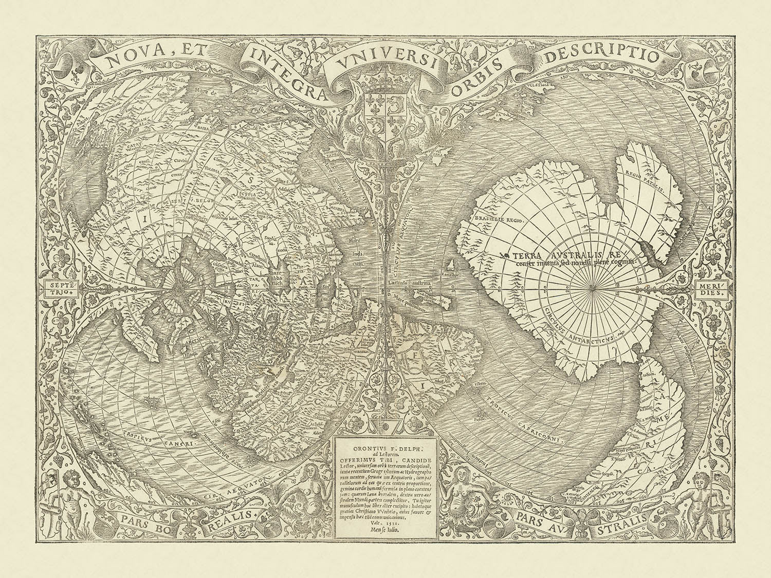
Step into the fascinating world of Renaissance cartography with Oronce Fine’s “Nova, et Integra Universi Orbis Descriptio,” a masterwork first published in...
Continue readingStep into the fascinating world of Renaissance cartography with Oronce Fine’s “Nova, et Integra Universi Orbis Descriptio,” a masterwork first published in 1531. This extraordinary map, the earliest known double cordiform (heart-shaped) projection of the world, stands as a testament to both the ambition and artistry of early modern mapmakers. Fine, an eminent French mathematician and geographer, ingeniously synthesized the latest discoveries of his era—most notably the voyages of Magellan and Cortez—into a vision of the globe that was both scientifically advanced and visually arresting. The map’s original Latin title, which translates to “A New and Complete Description of the Whole World,” perfectly encapsulates its groundbreaking scope and the spirit of exploration that defined the age.
Created at a time when the boundaries of the known world were rapidly expanding, Fine’s map captures the excitement and uncertainty of the early sixteenth century. It is one of the very first maps to mention the “Mare magellanicum,” honoring Ferdinand Magellan’s epochal circumnavigation. The map boldly delineates the mysterious Terra Australis—“recently discovered but not yet explored”—a vast southern continent that would tantalize explorers and geographers for centuries. Central America is richly annotated with place names reflecting the conquests and explorations of Cortez, while the North American continent is intriguingly rendered as an extension of Asia, revealing the evolving European understanding of global geography.
The map’s double cordiform projection is a marvel of geometric ingenuity, reducing the spherical earth to two elegantly interlocking heart-shaped lobes. This unique format, devised by Fine himself, would become a model for world maps for decades to follow, preceding the rise of oval and double-hemispheric projections and the eventual dominance of Mercator’s projection. The projection not only serves as a technical achievement but also imbues the map with a sense of harmony and unity, inviting the viewer to contemplate the interconnectedness of the world’s continents and oceans.
Aesthetically, Fine’s map is a triumph of Renaissance artistry. The detailed woodcut is framed by a lush floral border, flanked by two mermaids and muscular cherubs that evoke the mythic and the maritime. The French royal coat of arms is displayed with pride, while a flowing banner at the top proclaims the map’s title. The lower cartouche bears Fine’s own name, marking this as the coveted first state of the map—a rare and desirable feature for collectors and connoisseurs. Every element, from the ornate border to the meticulously engraved landmasses, reflects the humanist ideals and decorative sensibilities of its time.
Within its intricate design, the map reveals a world both familiar and fantastical. Greenland is shown as a separate island, while the Arctic is depicted as four enigmatic islands. The promontory labeled “Gaccalar”—thought to represent Labrador—juts boldly into the Atlantic. Mountain ranges, rivers, and coastlines are rendered with a detail that speaks to Fine’s dedication to accuracy, even as the limits of contemporary knowledge left vast regions shrouded in mystery. This map is not merely a record of the world as it was known in 1531; it is a celebration of discovery, imagination, and the enduring quest to chart the unknown.
Countries and regions on this map
- Europe
- Asia
- Africa
- America (North and South America, with North America depicted as part of Asia)
- Terra Australis (Southern continent, not yet explored)
- Greenland
- Gaccalar (Labrador)
- Central America (with specific place names from early Spanish exploration)
- Mare magellanicum (Magellan’s Sea, body of water)
- Arctic region (depicted as four islands)
Notable Features & Landmarks
- Double cordiform (heart-shaped) projection, split into two lobes
- Decorative floral border surrounding the map
- Two mermaids illustrated outside the map
- Two muscular cherubs (putti) depicted outside the map
- French royal coat of arms displayed prominently
- Flowing banner with the map’s title at the top
- Lower cartouche with Oronce Fine’s name (Orontius F. Delph)
- Mare magellanicum (Magellan’s Sea) labelled beyond the tip of South America
- Terra Australis ("recently discovered but not yet explored") occupies much of the southern lobe
- Four islands depicted at the North Pole
- Separate island labelled as Greenland
- Large promontory labelled Gaccalar (supposedly Labrador) extending from North America
- Numerous place names in Central America reflecting early Spanish exploration
- Detailed physical features such as mountain ranges and rivers
Historical and design context
- First double cordiform (heart-shaped) world map ever produced
- Created by Oronce Fine, an eminent French cartographer and mathematician, in 1531
- One of the earliest maps to mention Magellan (Mare magellanicum)
- Became a model for world maps for several decades before the rise of oval and double-hemispheric projections, and Mercator’s projection
- Based on sophisticated geometric principles for depicting the spherical earth in two dimensions
- Detailed woodcut with Renaissance artistry and humanist ideals
- First appeared in the 1532 Paris edition of Johann Huttich and Simon Grynaeus's Novus orbis regionum
- The first state of the map, the only one to feature Oronce Fine’s name in the lower cartouche
- Celebrates the spirit of exploration and discovery during the early sixteenth century
Please double check the images to make sure that a specific town or place is shown on this map. You can also get in touch and ask us to check the map for you.
This map looks great at every size, but I always recommend going for a larger size if you have space. That way you can easily make out all of the details.
This map looks amazing at sizes all the way up to 70in (180cm). If you are looking for a larger map, please get in touch.
The model in the listing images is holding the 18x24in (45x60cm) version of this map.
The fifth listing image shows an example of my map personalisation service.
If you’re looking for something slightly different, check out my collection of the best old maps to see if something else catches your eye.
Please contact me to check if a certain location, landmark or feature is shown on this map.
This would make a wonderful birthday, Christmas, Father's Day, work leaving, anniversary or housewarming gift for someone from the areas covered by this map.
This map is available as a giclée print on acid free archival matte paper, or you can buy it framed. The frame is a nice, simple black frame that suits most aesthetics. Please get in touch if you'd like a different frame colour or material. My frames are glazed with super-clear museum-grade acrylic (perspex/acrylite), which is significantly less reflective than glass, safer, and will always arrive in perfect condition.
This map is also available as a float framed canvas, sometimes known as a shadow gap framed canvas or canvas floater. The map is printed on artist's cotton canvas and then stretched over a handmade box frame. We then "float" the canvas inside a wooden frame, which is available in a range of colours (black, dark brown, oak, antique gold and white). This is a wonderful way to present a map without glazing in front. See some examples of float framed canvas maps and explore the differences between my different finishes.
For something truly unique, this map is also available in "Unique 3D", our trademarked process that dramatically transforms the map so that it has a wonderful sense of depth. We combine the original map with detailed topography and elevation data, so that mountains and the terrain really "pop". For more info and examples of 3D maps, check my Unique 3D page.
Step into the fascinating world of Renaissance cartography with Oronce Fine’s “Nova, et Integra Universi Orbis Descriptio,” a masterwork first published in 1531. This extraordinary map, the earliest known double cordiform (heart-shaped) projection of the world, stands as a testament to both the ambition and artistry of early modern mapmakers. Fine, an eminent French mathematician and geographer, ingeniously synthesized the latest discoveries of his era—most notably the voyages of Magellan and Cortez—into a vision of the globe that was both scientifically advanced and visually arresting. The map’s original Latin title, which translates to “A New and Complete Description of the Whole World,” perfectly encapsulates its groundbreaking scope and the spirit of exploration that defined the age.
Created at a time when the boundaries of the known world were rapidly expanding, Fine’s map captures the excitement and uncertainty of the early sixteenth century. It is one of the very first maps to mention the “Mare magellanicum,” honoring Ferdinand Magellan’s epochal circumnavigation. The map boldly delineates the mysterious Terra Australis—“recently discovered but not yet explored”—a vast southern continent that would tantalize explorers and geographers for centuries. Central America is richly annotated with place names reflecting the conquests and explorations of Cortez, while the North American continent is intriguingly rendered as an extension of Asia, revealing the evolving European understanding of global geography.
The map’s double cordiform projection is a marvel of geometric ingenuity, reducing the spherical earth to two elegantly interlocking heart-shaped lobes. This unique format, devised by Fine himself, would become a model for world maps for decades to follow, preceding the rise of oval and double-hemispheric projections and the eventual dominance of Mercator’s projection. The projection not only serves as a technical achievement but also imbues the map with a sense of harmony and unity, inviting the viewer to contemplate the interconnectedness of the world’s continents and oceans.
Aesthetically, Fine’s map is a triumph of Renaissance artistry. The detailed woodcut is framed by a lush floral border, flanked by two mermaids and muscular cherubs that evoke the mythic and the maritime. The French royal coat of arms is displayed with pride, while a flowing banner at the top proclaims the map’s title. The lower cartouche bears Fine’s own name, marking this as the coveted first state of the map—a rare and desirable feature for collectors and connoisseurs. Every element, from the ornate border to the meticulously engraved landmasses, reflects the humanist ideals and decorative sensibilities of its time.
Within its intricate design, the map reveals a world both familiar and fantastical. Greenland is shown as a separate island, while the Arctic is depicted as four enigmatic islands. The promontory labeled “Gaccalar”—thought to represent Labrador—juts boldly into the Atlantic. Mountain ranges, rivers, and coastlines are rendered with a detail that speaks to Fine’s dedication to accuracy, even as the limits of contemporary knowledge left vast regions shrouded in mystery. This map is not merely a record of the world as it was known in 1531; it is a celebration of discovery, imagination, and the enduring quest to chart the unknown.
Countries and regions on this map
- Europe
- Asia
- Africa
- America (North and South America, with North America depicted as part of Asia)
- Terra Australis (Southern continent, not yet explored)
- Greenland
- Gaccalar (Labrador)
- Central America (with specific place names from early Spanish exploration)
- Mare magellanicum (Magellan’s Sea, body of water)
- Arctic region (depicted as four islands)
Notable Features & Landmarks
- Double cordiform (heart-shaped) projection, split into two lobes
- Decorative floral border surrounding the map
- Two mermaids illustrated outside the map
- Two muscular cherubs (putti) depicted outside the map
- French royal coat of arms displayed prominently
- Flowing banner with the map’s title at the top
- Lower cartouche with Oronce Fine’s name (Orontius F. Delph)
- Mare magellanicum (Magellan’s Sea) labelled beyond the tip of South America
- Terra Australis ("recently discovered but not yet explored") occupies much of the southern lobe
- Four islands depicted at the North Pole
- Separate island labelled as Greenland
- Large promontory labelled Gaccalar (supposedly Labrador) extending from North America
- Numerous place names in Central America reflecting early Spanish exploration
- Detailed physical features such as mountain ranges and rivers
Historical and design context
- First double cordiform (heart-shaped) world map ever produced
- Created by Oronce Fine, an eminent French cartographer and mathematician, in 1531
- One of the earliest maps to mention Magellan (Mare magellanicum)
- Became a model for world maps for several decades before the rise of oval and double-hemispheric projections, and Mercator’s projection
- Based on sophisticated geometric principles for depicting the spherical earth in two dimensions
- Detailed woodcut with Renaissance artistry and humanist ideals
- First appeared in the 1532 Paris edition of Johann Huttich and Simon Grynaeus's Novus orbis regionum
- The first state of the map, the only one to feature Oronce Fine’s name in the lower cartouche
- Celebrates the spirit of exploration and discovery during the early sixteenth century
Please double check the images to make sure that a specific town or place is shown on this map. You can also get in touch and ask us to check the map for you.
This map looks great at every size, but I always recommend going for a larger size if you have space. That way you can easily make out all of the details.
This map looks amazing at sizes all the way up to 70in (180cm). If you are looking for a larger map, please get in touch.
The model in the listing images is holding the 18x24in (45x60cm) version of this map.
The fifth listing image shows an example of my map personalisation service.
If you’re looking for something slightly different, check out my collection of the best old maps to see if something else catches your eye.
Please contact me to check if a certain location, landmark or feature is shown on this map.
This would make a wonderful birthday, Christmas, Father's Day, work leaving, anniversary or housewarming gift for someone from the areas covered by this map.
This map is available as a giclée print on acid free archival matte paper, or you can buy it framed. The frame is a nice, simple black frame that suits most aesthetics. Please get in touch if you'd like a different frame colour or material. My frames are glazed with super-clear museum-grade acrylic (perspex/acrylite), which is significantly less reflective than glass, safer, and will always arrive in perfect condition.
This map is also available as a float framed canvas, sometimes known as a shadow gap framed canvas or canvas floater. The map is printed on artist's cotton canvas and then stretched over a handmade box frame. We then "float" the canvas inside a wooden frame, which is available in a range of colours (black, dark brown, oak, antique gold and white). This is a wonderful way to present a map without glazing in front. See some examples of float framed canvas maps and explore the differences between my different finishes.
For something truly unique, this map is also available in "Unique 3D", our trademarked process that dramatically transforms the map so that it has a wonderful sense of depth. We combine the original map with detailed topography and elevation data, so that mountains and the terrain really "pop". For more info and examples of 3D maps, check my Unique 3D page.
Many of our maps and art prints are chosen as thoughtful gifts for homes, offices, studies and meaningful places.
Choose a framed option for the easiest ready-to-hang gift, or choose an unframed print if the recipient may prefer to select their own frame.
We make orders locally in 23 countries around the world, so gifts can often be produced close to the recipient. This helps them arrive faster, travel more safely, and avoid customs or import duty surprises.
- We can deliver directly to the recipient
- Framed pieces arrive ready to hang
- Unframed prints are carefully packed in a strong protective tube
- Almost every order is made locally, for faster, safer gifting
- 90-day returns give the recipient time to decide
If you are not sure what to choose, please contact us. We can help you pick the right map, size, finish or delivery option.
Most orders are made locally and delivered in around 2–3 working days, depending on the product, size and destination.
We print and frame maps and artwork in 23 countries around the world, so your order is usually made close to you or your recipient. That means faster delivery, less time in transit, and no customs or import duty surprises.
Personalised and customised pieces usually take an extra 1–2 working days, because we prepare your design and send it to you for approval before printing.
Very large framed orders can take a little longer, as they need extra care in production and delivery.
Every order is carefully packaged: unframed prints are sent in a strong protective tube, while framed pieces are securely packed with protective materials around the frame.
If you need your order by a particular date, please contact us before ordering. We’ll check the best production route and delivery option for your location.
Express delivery is available at checkout for most countries. Next-day delivery is available in the UK, US, Singapore and the UAE.
Your order is covered by our 90-day returns policy and 10-year guarantee.
Our standard frame is a gallery-style black ash hardwood frame, with a simple, modern look. It is approximately 20mm (0.8in) wide. You can also view some lovely customer photos of framed maps and art.
We use super-clear acrylic glazing, also known as Perspex or Acrylite, instead of traditional glass. It is lighter, safer, and has lower reflectivity, giving the artwork a clearer, cleaner appearance.
Six standard frame colours are available at no extra cost: black, dark brown, dark grey, oak, white, and antique gold. Custom framing and mounting/matting is also available for customers looking for something more specific.
Most maps, art prints, and illustrations are also available as a framed canvas. We use matte cotton canvas, stretch it over a sustainably sourced wooden box frame, and then float the piece within a wooden outer frame. The finished result is beautifully presented, with no glazing between you and the artwork.
All frames are supplied ready to hang, with either string or brackets fitted to the back. Very large frames will include heavy-duty hanging plates and/or a mounting baton. If you have any questions, please get in touch.
We can also supply old maps and artwork on canvas, foam board, cotton rag, and other materials.
If you would prefer to frame your map or artwork yourself, please read our size guide before ordering.
My maps are extremely high quality reproductions of original maps.
I source original, rare maps from libraries, auction houses and private collections around the world, restore them at my London workshop, and then use specialist giclée inks and printers to create beautiful maps that look even better than the original.
My maps are printed on acid-free archival matte (not glossy) paper that feels very high quality and almost like card. In technical terms the paper weight/thickness is 10mil/200gsm. It's perfect for framing.
I print with Epson ultrachrome giclée UV fade resistant pigment inks - some of the best inks you can find.
I can also make maps on canvas, cotton rag and other exotic materials.
Learn more about The Unique Maps Co.
Map personalisation
If you're looking for the perfect anniversary or housewarming gift, I can personalise your map to make it truly unique. For example, I can add a short message, or highlight an important location, or add your family's coat of arms.
The options are almost infinite. Please see my map personalisation page for some wonderful examples of what's possible.
To order a personalised map, select "personalise your map" before adding it to your basket.
Get in touch if you're looking for more complex customisations and personalisations.
Map ageing
I have been asked hundreds of times over the years by customers if they could buy a map that looks even older.
Well, now you can, by selecting Aged before you add a map to your basket.
All the product photos you see on this page show the map in its Original form. This is what the map looks like today.
If you select Aged, I will age your map by hand, using a special and unique process developed through years of studying old maps, talking to researchers to understand the chemistry of aging paper, and of course... lots of practice!
If you're unsure, stick to the Original colour of the map. If you want something a bit darker and older looking, go for Aged.
If you are not happy with your order for any reason, contact me and I'll get it fixed ASAP, free of charge. Please see my returns and refund policy for more information.
I am very confident you will like your restored map or art print. I have been doing this since 1984. I'm a 5-star Etsy seller. I have sold tens of thousands of maps and art prints and have over 5,000 real 5-star reviews. My work has been featured in interior design magazines, on the BBC, and on the walls of dozens of 5-star hotels.
I use a unique process to restore maps and artwork that is massively time consuming and labour intensive. Hunting down the original maps and illustrations can take months. I use state of the art and eye-wateringly expensive technology to scan and restore them. As a result, I guarantee my maps and art prints are a cut above the rest. I stand by my products and will always make sure you're 100% happy with what you receive.
Almost all of my maps and art prints look amazing at large sizes (200cm, 6.5ft+) and I can frame and deliver them to you as well, via special oversized courier. Contact me to discuss your specific needs.
Or try searching for something!


