


Rare Old Railway Map of Great Britain by Tallis, 1850: London, Liverpool, Manchester, Steamboat Routes, Ornate Borders
The Collector’s Offer
Choose two eligible works and receive 20% off both. Choose three and the lowest-priced one is complimentary, a maximum saving of 33%.
Mix and match eligible standard maps and fine-art prints. No code is required; the offer is applied automatically at checkout.
Standard made-to-order configurations are included. Bespoke sizes, personalised designs and commissioned work are excluded.
Need delivery to different addresses? Contact us before ordering.The Collector’s Offer
Choose two eligible works and receive 20% off both. Choose three and the lowest-priced one is complimentary, a maximum saving of 33%.
Mix and match eligible standard maps and fine-art prints. No code is required; the offer is applied automatically at checkout.
Standard made-to-order configurations are included. Bespoke sizes, personalised designs and commissioned work are excluded.
Need delivery to different addresses? Contact us before ordering. Restored in London • Made in the EU

Restored from the original 1850 map and printed to museum-grade archival standards. Read the story behind this map
Choose your size
Choose your finish


(More info)
Gift message & custom finish

If you want to add a gift message, or a finish (jigsaw, aluminium board, etc.) that is not available here, please request it in the "order note" when you check out.
Every order is custom made, so if you need the size adjusted slightly, or printed on an unusual material, just let us know. We've done thousands of custom orders over the years, so there's (almost) nothing we can't manage.
You can also contact us before you order, if you prefer!

- Made in the EU for fast, safe delivery
- No import duty or hidden fees
- Need advice? Call us or message on WhatsApp
Own a piece of history
8,000+ five-star reviews


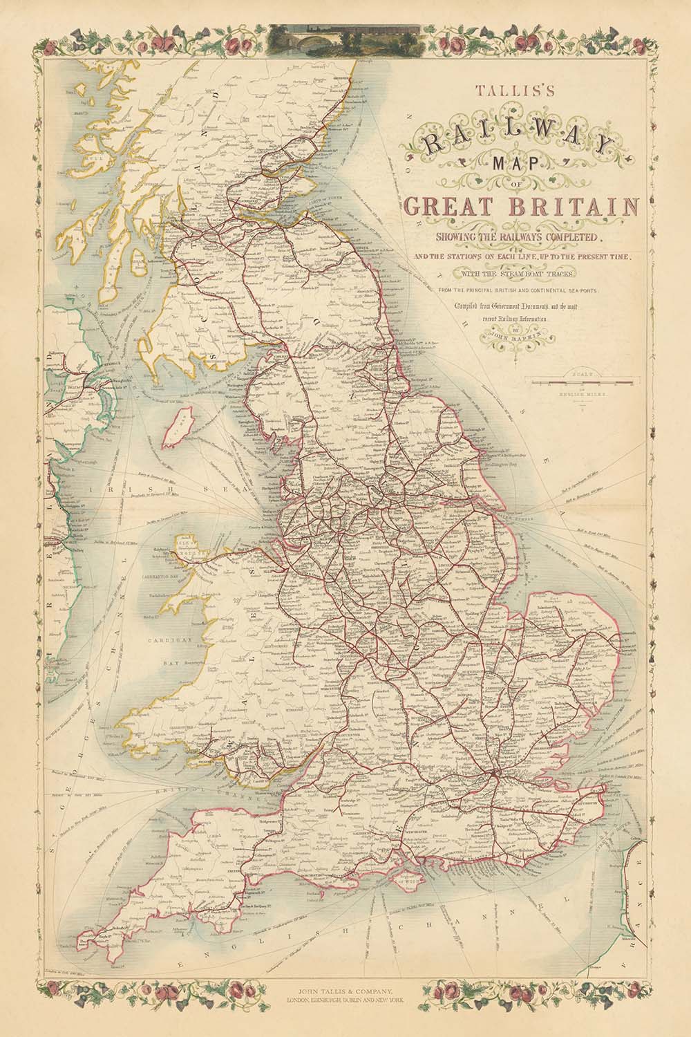
Step into the dynamic world of Victorian Britain with “Tallis’s Railway Map of Great Britain Showing the Railways Completed, and the Stations...
Continue readingStep into the dynamic world of Victorian Britain with “Tallis’s Railway Map of Great Britain Showing the Railways Completed, and the Stations on Each Line, Up To The Present Time, with the Steamboat Tracks From the Principal British and Continental Ports.” Crafted in 1850 by the celebrated publisher John Tallis and the skilled engraver John Rapkin, this map stands as a testament to the era’s feverish pace of innovation and connectivity. At a glance, it reveals the intricate web of railways that transformed the landscape, threading together the great cities and towns of England, Scotland, and Wales during the zenith of the Industrial Revolution.
John Tallis, renowned for his elegant and decorative cartographic works, imbued this map with a sense of grandeur and clarity. Collaborating with John Rapkin, whose meticulous engraving brought the details to life, Tallis ensured that every line and station was not only accurate—painstakingly compiled from government documents and the latest railway intelligence—but also visually captivating. The map’s ornate border is beautiful.
The map’s thematic focus on railways and steamboat routes encapsulates the sweeping changes of the mid-19th century. Major railway lines radiate from London, Birmingham, Manchester, and Glasgow, connecting burgeoning industrial centers with coastal ports and rural hinterlands. Steamboat tracks arc across the North Sea, English Channel, and Irish Sea, linking British harbors to continental Europe and underscoring the global reach of British commerce. Each railway station and route is meticulously marked, offering a snapshot of a country in the midst of unprecedented mobility and economic transformation.
Beyond its transportation networks, the map is a celebration of Britain’s rich and varied geography. The rolling hills of Wales, the rugged Highlands of Scotland, and the fertile plains of England are all subtly suggested, while major rivers like the Thames, Severn, and Clyde carve their way through the landscape. Decorative illustrations evoke the spirit of the age: mighty bridges, bustling harbors, and the proud figure of Britannia, all set against a backdrop of natural beauty and industrial prowess. Borders between England, Scotland, and Wales are clearly delineated, and county boundaries offer further insight into the administrative landscape of the time.
This map is more than a navigational aid; it is a historical document that captures the essence of a nation on the move. It charts the rise of cities such as London, Birmingham, Liverpool, and Glasgow—now global metropolises—and records the names of towns and regions that have shaped British identity for centuries. Whether admired for its artistry, its historical significance, or its sheer ambition, this map invites the viewer to journey back to a pivotal moment in Britain’s story, when iron rails and steam power redrew the contours of everyday life.
Cities and towns on this map
-
England
- London
- Birmingham
- Manchester
- Liverpool
- Leeds
- Sheffield
- Newcastle (Newcastle upon Tyne)
- Bristol
- Nottingham
- Leicester
- Portsmouth
- Southampton
- Derby
- York
- Norwich
- Exeter
- Carlisle
- Plymouth
- Hull (Kingston upon Hull)
- Sunderland
- Wolverhampton
- Stoke (Stoke-on-Trent)
- Preston
- Lancaster
- Chester
- Bath
- Oxford
- Cambridge
- Brighton
-
Scotland
- Glasgow
- Edinburgh
- Aberdeen
- Dundee
- Inverness
- Perth
- Stirling
-
Wales
- Cardiff
- Swansea
- Newport
- Bangor
- Wrexham
Notable Features & Landmarks
- Decorative border: Ornate, floral and scrollwork border framing the map, typical of Tallis’s publications
- Bodies of water:
- The North Sea (labelled as German Ocean)
- The English Channel
- The Irish Sea
- Various estuaries and firths (e.g., Firth of Forth, Solway Firth)
- Borders:
- Clearly delineated borders between England, Scotland, and Wales
- County boundaries within each country
- Steamboat tracks: Dashed or highlighted lines across the sea, connecting British ports to continental destinations
- Railways: Prominently marked railway lines crisscrossing the country, with stations indicated
- Mountains and terrain: Hilly and mountainous terrain indicated, especially in Scotland and Wales, though stylized rather than topographically precise
- Major rivers (e.g., Thames, Severn, Mersey, Clyde) are labelled
Historical and design context
- Created in 1850, during the height of the Industrial Revolution
- Published by John Tallis, a renowned 19th-century publisher known for elegant and decorative maps
- Cartography by John Rapkin, a skilled engraver and frequent Tallis collaborator
- Thematic focus on railway infrastructure and steamboat routes, reflecting Britain’s rapid industrial and socio-economic transformation
- Meticulously compiled from government documents and the latest railway intelligence of the time
- Captures the expansion of Britain’s railways and increased national mobility
- Decorative borders and engraved illustrations enhance both visual appeal and historical value
- Serves as a primary source for understanding mid-19th century British transport and geography
- Offers insight into the administrative landscape with clearly marked county boundaries
Please double check the images to make sure that a specific town or place is shown on this map. You can also get in touch and ask us to check the map for you.
This map looks great at every size, but I always recommend going for a larger size if you have space. That way you can easily make out all of the details.
This map looks amazing at sizes all the way up to 90in (230cm). If you are looking for a larger map, please get in touch.
Please note: the labels on this map are hard to read if you order a map that is 16in (40cm) or smaller. The map is still very attractive, but if you would like to read the map easily, please buy a larger size.
The model in the listing images is holding the 24x36in (60x90cm) version of this map.
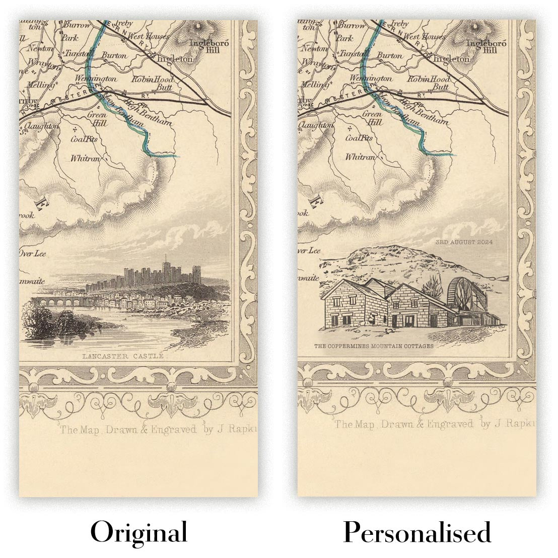
The fifth listing image shows an example of my map personalisation service.
If you’re looking for something slightly different, check out my collection of the best old maps to see if something else catches your eye.
Please contact me to check if a certain location, landmark or feature is shown on this map.
This would make a wonderful birthday, Christmas, Father's Day, work leaving, anniversary or housewarming gift for someone from the areas covered by this map.
This map is available as a giclée print on acid free archival matte paper, or you can buy it framed. The frame is a nice, simple black frame that suits most aesthetics. Please get in touch if you'd like a different frame colour or material. My frames are glazed with super-clear museum-grade acrylic (perspex/acrylite), which is significantly less reflective than glass, safer, and will always arrive in perfect condition.
This map is also available as a float framed canvas, sometimes known as a shadow gap framed canvas or canvas floater. The map is printed on artist's cotton canvas and then stretched over a handmade box frame. We then "float" the canvas inside a wooden frame, which is available in a range of colours (black, dark brown, oak, antique gold and white). This is a wonderful way to present a map without glazing in front. See some examples of float framed canvas maps and explore the differences between my different finishes.
For something truly unique, this map is also available in "Unique 3D", our trademarked process that dramatically transforms the map so that it has a wonderful sense of depth. We combine the original map with detailed topography and elevation data, so that mountains and the terrain really "pop". For more info and examples of 3D maps, check my Unique 3D page.
Step into the dynamic world of Victorian Britain with “Tallis’s Railway Map of Great Britain Showing the Railways Completed, and the Stations on Each Line, Up To The Present Time, with the Steamboat Tracks From the Principal British and Continental Ports.” Crafted in 1850 by the celebrated publisher John Tallis and the skilled engraver John Rapkin, this map stands as a testament to the era’s feverish pace of innovation and connectivity. At a glance, it reveals the intricate web of railways that transformed the landscape, threading together the great cities and towns of England, Scotland, and Wales during the zenith of the Industrial Revolution.
John Tallis, renowned for his elegant and decorative cartographic works, imbued this map with a sense of grandeur and clarity. Collaborating with John Rapkin, whose meticulous engraving brought the details to life, Tallis ensured that every line and station was not only accurate—painstakingly compiled from government documents and the latest railway intelligence—but also visually captivating. The map’s ornate border is beautiful.
The map’s thematic focus on railways and steamboat routes encapsulates the sweeping changes of the mid-19th century. Major railway lines radiate from London, Birmingham, Manchester, and Glasgow, connecting burgeoning industrial centers with coastal ports and rural hinterlands. Steamboat tracks arc across the North Sea, English Channel, and Irish Sea, linking British harbors to continental Europe and underscoring the global reach of British commerce. Each railway station and route is meticulously marked, offering a snapshot of a country in the midst of unprecedented mobility and economic transformation.
Beyond its transportation networks, the map is a celebration of Britain’s rich and varied geography. The rolling hills of Wales, the rugged Highlands of Scotland, and the fertile plains of England are all subtly suggested, while major rivers like the Thames, Severn, and Clyde carve their way through the landscape. Decorative illustrations evoke the spirit of the age: mighty bridges, bustling harbors, and the proud figure of Britannia, all set against a backdrop of natural beauty and industrial prowess. Borders between England, Scotland, and Wales are clearly delineated, and county boundaries offer further insight into the administrative landscape of the time.
This map is more than a navigational aid; it is a historical document that captures the essence of a nation on the move. It charts the rise of cities such as London, Birmingham, Liverpool, and Glasgow—now global metropolises—and records the names of towns and regions that have shaped British identity for centuries. Whether admired for its artistry, its historical significance, or its sheer ambition, this map invites the viewer to journey back to a pivotal moment in Britain’s story, when iron rails and steam power redrew the contours of everyday life.
Cities and towns on this map
-
England
- London
- Birmingham
- Manchester
- Liverpool
- Leeds
- Sheffield
- Newcastle (Newcastle upon Tyne)
- Bristol
- Nottingham
- Leicester
- Portsmouth
- Southampton
- Derby
- York
- Norwich
- Exeter
- Carlisle
- Plymouth
- Hull (Kingston upon Hull)
- Sunderland
- Wolverhampton
- Stoke (Stoke-on-Trent)
- Preston
- Lancaster
- Chester
- Bath
- Oxford
- Cambridge
- Brighton
-
Scotland
- Glasgow
- Edinburgh
- Aberdeen
- Dundee
- Inverness
- Perth
- Stirling
-
Wales
- Cardiff
- Swansea
- Newport
- Bangor
- Wrexham
Notable Features & Landmarks
- Decorative border: Ornate, floral and scrollwork border framing the map, typical of Tallis’s publications
- Bodies of water:
- The North Sea (labelled as German Ocean)
- The English Channel
- The Irish Sea
- Various estuaries and firths (e.g., Firth of Forth, Solway Firth)
- Borders:
- Clearly delineated borders between England, Scotland, and Wales
- County boundaries within each country
- Steamboat tracks: Dashed or highlighted lines across the sea, connecting British ports to continental destinations
- Railways: Prominently marked railway lines crisscrossing the country, with stations indicated
- Mountains and terrain: Hilly and mountainous terrain indicated, especially in Scotland and Wales, though stylized rather than topographically precise
- Major rivers (e.g., Thames, Severn, Mersey, Clyde) are labelled
Historical and design context
- Created in 1850, during the height of the Industrial Revolution
- Published by John Tallis, a renowned 19th-century publisher known for elegant and decorative maps
- Cartography by John Rapkin, a skilled engraver and frequent Tallis collaborator
- Thematic focus on railway infrastructure and steamboat routes, reflecting Britain’s rapid industrial and socio-economic transformation
- Meticulously compiled from government documents and the latest railway intelligence of the time
- Captures the expansion of Britain’s railways and increased national mobility
- Decorative borders and engraved illustrations enhance both visual appeal and historical value
- Serves as a primary source for understanding mid-19th century British transport and geography
- Offers insight into the administrative landscape with clearly marked county boundaries
Please double check the images to make sure that a specific town or place is shown on this map. You can also get in touch and ask us to check the map for you.
This map looks great at every size, but I always recommend going for a larger size if you have space. That way you can easily make out all of the details.
This map looks amazing at sizes all the way up to 90in (230cm). If you are looking for a larger map, please get in touch.
Please note: the labels on this map are hard to read if you order a map that is 16in (40cm) or smaller. The map is still very attractive, but if you would like to read the map easily, please buy a larger size.
The model in the listing images is holding the 24x36in (60x90cm) version of this map.
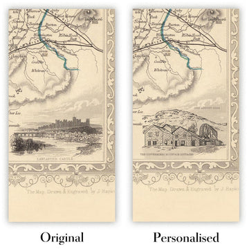
The fifth listing image shows an example of my map personalisation service.
If you’re looking for something slightly different, check out my collection of the best old maps to see if something else catches your eye.
Please contact me to check if a certain location, landmark or feature is shown on this map.
This would make a wonderful birthday, Christmas, Father's Day, work leaving, anniversary or housewarming gift for someone from the areas covered by this map.
This map is available as a giclée print on acid free archival matte paper, or you can buy it framed. The frame is a nice, simple black frame that suits most aesthetics. Please get in touch if you'd like a different frame colour or material. My frames are glazed with super-clear museum-grade acrylic (perspex/acrylite), which is significantly less reflective than glass, safer, and will always arrive in perfect condition.
This map is also available as a float framed canvas, sometimes known as a shadow gap framed canvas or canvas floater. The map is printed on artist's cotton canvas and then stretched over a handmade box frame. We then "float" the canvas inside a wooden frame, which is available in a range of colours (black, dark brown, oak, antique gold and white). This is a wonderful way to present a map without glazing in front. See some examples of float framed canvas maps and explore the differences between my different finishes.
For something truly unique, this map is also available in "Unique 3D", our trademarked process that dramatically transforms the map so that it has a wonderful sense of depth. We combine the original map with detailed topography and elevation data, so that mountains and the terrain really "pop". For more info and examples of 3D maps, check my Unique 3D page.
Many of our maps and art prints are chosen as thoughtful gifts for homes, offices, studies and meaningful places.
Choose a framed option for the easiest ready-to-hang gift, or choose an unframed print if the recipient may prefer to select their own frame.
We make orders locally in 23 countries around the world, so gifts can often be produced close to the recipient. This helps them arrive faster, travel more safely, and avoid customs or import duty surprises.
- We can deliver directly to the recipient
- Framed pieces arrive ready to hang
- Unframed prints are carefully packed in a strong protective tube
- Almost every order is made locally, for faster, safer gifting
- 90-day returns give the recipient time to decide
If you are not sure what to choose, please contact us. We can help you pick the right map, size, finish or delivery option.
Most orders are made locally and delivered in around 2–3 working days, depending on the product, size and destination.
We print and frame maps and artwork in 23 countries around the world, so your order is usually made close to you or your recipient. That means faster delivery, less time in transit, and no customs or import duty surprises.
Personalised and customised pieces usually take an extra 1–2 working days, because we prepare your design and send it to you for approval before printing.
Very large framed orders can take a little longer, as they need extra care in production and delivery.
Every order is carefully packaged: unframed prints are sent in a strong protective tube, while framed pieces are securely packed with protective materials around the frame.
If you need your order by a particular date, please contact us before ordering. We’ll check the best production route and delivery option for your location.
Express delivery is available at checkout for most countries. Next-day delivery is available in the UK, US, Singapore and the UAE.
Your order is covered by our 90-day returns policy and 10-year guarantee.
Our standard frame is a gallery-style black ash hardwood frame, with a simple, modern look. It is approximately 20mm (0.8in) wide. You can also view some lovely customer photos of framed maps and art.
We use super-clear acrylic glazing, also known as Perspex or Acrylite, instead of traditional glass. It is lighter, safer, and has lower reflectivity, giving the artwork a clearer, cleaner appearance.
Six standard frame colours are available at no extra cost: black, dark brown, dark grey, oak, white, and antique gold. Custom framing and mounting/matting is also available for customers looking for something more specific.
Most maps, art prints, and illustrations are also available as a framed canvas. We use matte cotton canvas, stretch it over a sustainably sourced wooden box frame, and then float the piece within a wooden outer frame. The finished result is beautifully presented, with no glazing between you and the artwork.
All frames are supplied ready to hang, with either string or brackets fitted to the back. Very large frames will include heavy-duty hanging plates and/or a mounting baton. If you have any questions, please get in touch.
We can also supply old maps and artwork on canvas, foam board, cotton rag, and other materials.
If you would prefer to frame your map or artwork yourself, please read our size guide before ordering.
Every Unique Maps piece begins with an authentic cartographic source or an original design from our London studio.
For our historic maps, we source rare originals from libraries, archives, auction houses and private collections around the world. We carefully restore each map for print—repairing age-related damage, balancing colour and improving clarity while preserving its original detail, texture and character.
Once restored, the map is prepared for your chosen size and finish. Your piece is then printed and, where selected, framed close to its delivery destination.
Our map prints use acid-free 200gsm archival matte paper and fade-resistant pigment inks, creating a rich, non-glossy finish designed to last. Framed maps use crystal-clear optical acrylic and arrive ready to hang.
Canvas, cotton-rag and other specialist presentations are also available. Learn more about our materials and finishes.
Personalising your map
You can add a short title or dedication, mark one meaningful place, or request one considered visual detail. For personalised designs, we send a proof before printing and you can request changes before approval.
For more complex bespoke commissions, contact our design team.
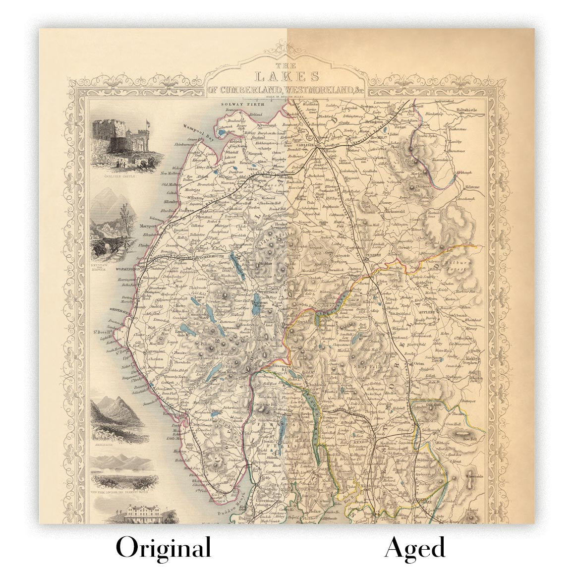
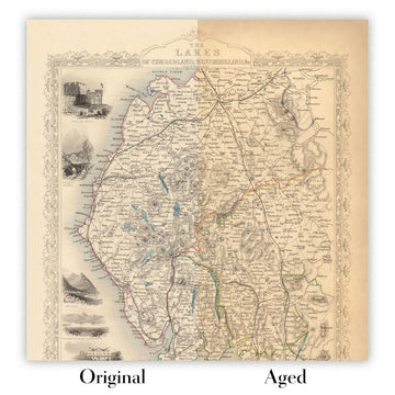
Original or Aged
Choose Original for true-to-source colour, or Aged for a warmer, richer antique character created with our specialist ageing process. See examples of our Aged maps.
If you are not happy with your order for any reason, contact me and I'll get it fixed ASAP, free of charge. Please see my returns and refund policy for more information.
I am very confident you will like your restored map or art print. I have been doing this since 1984. I'm a 5-star Etsy seller. I have sold tens of thousands of maps and art prints and have over 5,000 real 5-star reviews. My work has been featured in interior design magazines, on the BBC, and on the walls of dozens of 5-star hotels.
I use a unique process to restore maps and artwork that is massively time consuming and labour intensive. Hunting down the original maps and illustrations can take months. I use state of the art and eye-wateringly expensive technology to scan and restore them. As a result, I guarantee my maps and art prints are a cut above the rest. I stand by my products and will always make sure you're 100% happy with what you receive.
Almost all of my maps and art prints look amazing at large sizes (200cm, 6.5ft+) and I can frame and deliver them to you as well, via special oversized courier. Contact me to discuss your specific needs.
Or try searching for something!


