


Massive Old Map of Europe by Visscher, 1677: Triple Alliance, Capital City Views
The Collector’s Offer
Choose two eligible works and receive 20% off both. Choose three and the lowest-priced one is complimentary, a maximum saving of 33%.
Mix and match eligible standard maps and fine-art prints. No code is required; the offer is applied automatically at checkout.
Standard made-to-order configurations are included. Bespoke sizes, personalised designs and commissioned work are excluded.
Need delivery to different addresses? Contact us before ordering.The Collector’s Offer
Choose two eligible works and receive 20% off both. Choose three and the lowest-priced one is complimentary, a maximum saving of 33%.
Mix and match eligible standard maps and fine-art prints. No code is required; the offer is applied automatically at checkout.
Standard made-to-order configurations are included. Bespoke sizes, personalised designs and commissioned work are excluded.
Need delivery to different addresses? Contact us before ordering. Restored in London • Made in the EU

Restored from the original 1677 map and printed to museum-grade archival standards. Read the story behind this map
Choose your size
Choose your finish


(More info)
Gift message & custom finish

If you want to add a gift message, or a finish (jigsaw, aluminium board, etc.) that is not available here, please request it in the "order note" when you check out.
Every order is custom made, so if you need the size adjusted slightly, or printed on an unusual material, just let us know. We've done thousands of custom orders over the years, so there's (almost) nothing we can't manage.
You can also contact us before you order, if you prefer!

- Made locally for fast, safe delivery
- No import duty or hidden fees
- Need advice? Call us or message on WhatsApp
Own a piece of history
8,000+ five-star reviews


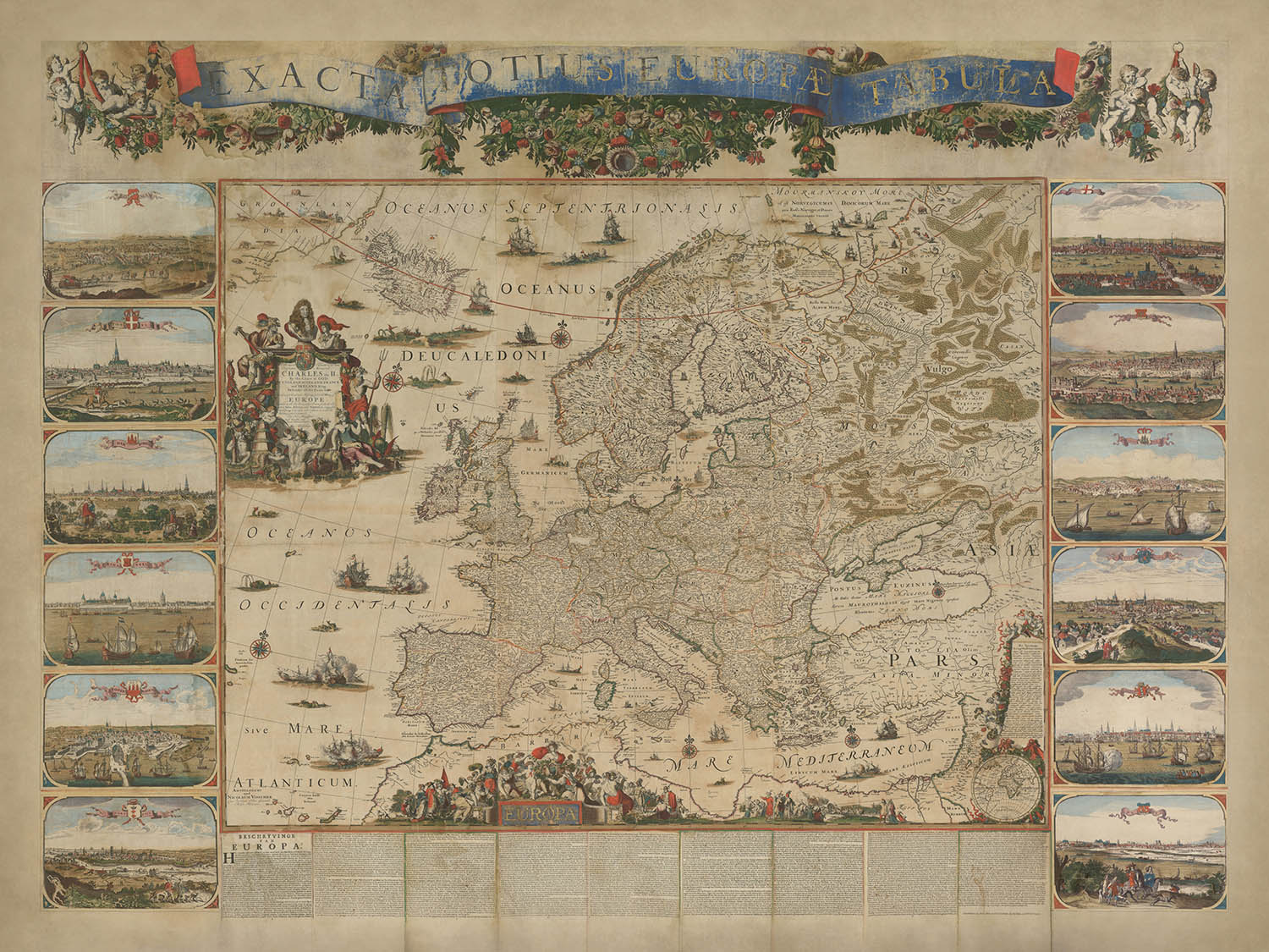
Step into the 17th century with Nicolaes Visscher II’s "Exacta Totius Europae Tabula", a breathtaking wall map that masterfully captures the political...
Continue readingStep into the 17th century with Nicolaes Visscher II’s "Exacta Totius Europae Tabula", a breathtaking wall map that masterfully captures the political and physical geography of Europe during a pivotal moment in history. Created in 1677, this map commemorates the formation of the Triple Alliance between the Netherlands, Sweden, and England—a short-lived but significant coalition that shaped the balance of power in Europe. Dedicated to King Charles II of England, the map celebrates this diplomatic milestone, underscoring the unity of these nations against common threats and laying the groundwork for future alliances.
Visscher’s artistic brilliance is on full display in this map, which blends cartographic precision with elaborate decorative elements. The map’s central focus is a detailed rendering of Europe, featuring meticulously drawn coastlines, rivers, and mountain ranges. Surrounding the map are vibrant allegorical illustrations, including a portrait of King Charles II, maritime scenes, and symbolic depictions of unity and power. These embellishments elevate the map from a practical tool to a work of art, reflecting the grandeur and aspirations of its time.
The map’s design is a testament to the Visscher family’s reputation for excellence in cartography. Nicolaes Visscher II, following in the footsteps of his father and grandfather, infused this map with both scientific accuracy and artistic flair. The cartographic projection showcases Europe’s geography with remarkable clarity, while the inclusion of city views and annotations provides a rich historical context. This dual focus on aesthetics and information exemplifies the Dutch Golden Age of cartography, a period when maps were as much about storytelling as they were about navigation.
Beyond its geographical detail, the map serves as a historical document, offering insights into the political dynamics of the late 17th century. The Triple Alliance, formed to counter the expansionist ambitions of France, is a central theme, symbolized through the map’s dedication and allegorical imagery. The alliance’s eventual dissolution and the subsequent Franco-Dutch War highlight the fluidity of European politics, making this map a snapshot of a fleeting yet transformative moment in history.
This map is not merely a depiction of land and sea but a celebration of Europe’s cultural and political landscape. The surrounding illustrations of major cities—such as London, Paris, and Amsterdam—capture the architectural splendor and significance of these urban centers. Ships dotting the oceans and seas evoke the era’s maritime dominance, while the ornate cartouches and banners add a layer of regal elegance. Nicolaes Visscher II’s "Exacta Totius Europae Tabula" is a masterpiece that transcends its cartographic purpose, offering a window into the artistry, history, and diplomacy of a bygone era.
Countries and regions on this map
- Continents:
- Europe (central focus).
- Parts of Asia (western regions).
- Northern Africa (coastal areas).
- Countries and regions:
- England, Scotland, Ireland.
- France, Spain, Portugal.
- The Netherlands, Belgium.
- Germany, Austria, Switzerland.
- Italy and the Italian states.
- Poland, Lithuania.
- Sweden, Norway, Denmark.
- Russia (western parts).
- Ottoman Empire (European territories).
- Hungary, Bohemia.
- Balkan regions.
- Greece and surrounding islands.
Notable Features & Landmarks
- Inset illustrations:
- Depictions of prominent European cities, including their architectural and cultural landmarks.
- Cities such as London, Paris, and Amsterdam are highlighted.
- Bodies of water:
- Major seas and oceans, including the Atlantic Ocean, Mediterranean Sea, and Baltic Sea.
- Smaller bodies of water, including regional seas and bays.
- Mountain ranges:
- Major European mountain ranges, such as the Alps and Carpathians, are illustrated with stylized relief.
- Decorative elements:
- Allegorical figures and symbols celebrating the Triple Alliance.
- Ornate cartouches and banners, including one with the map’s title.
- Illustrations of ships in the seas, emphasizing maritime activity.
- Historical notes and annotations:
- Text blocks at the bottom of the map provide historical and geographical context.
- Dedication to King Charles II and references to the Triple Alliance.
- Other features:
- Detailed coastlines and rivers.
- Depictions of naval engagements or fleets, reflecting the importance of maritime power.
Historical and design context
- Historical significance:
- Created in 1677 to commemorate the Triple Alliance (1668–1672) between the Netherlands, Sweden, and England.
- Dedicated to King Charles II of England, emphasizing the alliance’s importance to England and its European neighbors.
- The alliance was a precursor to the Grand Alliance, which fought major European wars such as the Nine Years' War (1688–1697) and the War of the Spanish Succession (1701–1714).
- Themes and topics:
- Political and physical geography of Europe during the 17th century.
- Maritime and coastal regions, reflecting the significance of naval power and trade routes.
- Design and style:
- Lavishly decorated with allegorical and symbolic illustrations.
- Vibrant city views and illustrations of major European urban centers.
- Blends cartographic precision with artistic flair, exemplifying the Dutch Golden Age of cartography.
- Includes a portrait of King Charles II and allegorical imagery symbolizing unity and power.
Please double check the images to make sure that a specific town or place is shown on this map. You can also get in touch and ask us to check the map for you.
This is a very large map that must be ordered at a large size, so that you can easily make out all of the details.
This map looks amazing at sizes all the way up to 100in (250cm). If you are looking for a larger map, please get in touch.
The model in the listing images is holding the 18x24in (45x60cm) version of this map.
The fifth listing image shows an example of my map personalisation service.
If you’re looking for something slightly different, check out my collection of the best old maps to see if something else catches your eye.
Please contact me to check if a certain location, landmark or feature is shown on this map.
This would make a wonderful birthday, Christmas, Father's Day, work leaving, anniversary or housewarming gift for someone from the areas covered by this map.
This map is available as a giclée print on acid free archival matte paper, or you can buy it framed. The frame is a nice, simple black frame that suits most aesthetics. Please get in touch if you'd like a different frame colour or material. My frames are glazed with super-clear museum-grade acrylic (perspex/acrylite), which is significantly less reflective than glass, safer, and will always arrive in perfect condition.
This map is also available as a float framed canvas, sometimes known as a shadow gap framed canvas or canvas floater. The map is printed on artist's cotton canvas and then stretched over a handmade box frame. We then "float" the canvas inside a wooden frame, which is available in a range of colours (black, dark brown, oak, antique gold and white). This is a wonderful way to present a map without glazing in front. See some examples of float framed canvas maps and explore the differences between my different finishes.
For something truly unique, this map is also available in "Unique 3D", our trademarked process that dramatically transforms the map so that it has a wonderful sense of depth. We combine the original map with detailed topography and elevation data, so that mountains and the terrain really "pop". For more info and examples of 3D maps, check my Unique 3D page.
Step into the 17th century with Nicolaes Visscher II’s "Exacta Totius Europae Tabula", a breathtaking wall map that masterfully captures the political and physical geography of Europe during a pivotal moment in history. Created in 1677, this map commemorates the formation of the Triple Alliance between the Netherlands, Sweden, and England—a short-lived but significant coalition that shaped the balance of power in Europe. Dedicated to King Charles II of England, the map celebrates this diplomatic milestone, underscoring the unity of these nations against common threats and laying the groundwork for future alliances.
Visscher’s artistic brilliance is on full display in this map, which blends cartographic precision with elaborate decorative elements. The map’s central focus is a detailed rendering of Europe, featuring meticulously drawn coastlines, rivers, and mountain ranges. Surrounding the map are vibrant allegorical illustrations, including a portrait of King Charles II, maritime scenes, and symbolic depictions of unity and power. These embellishments elevate the map from a practical tool to a work of art, reflecting the grandeur and aspirations of its time.
The map’s design is a testament to the Visscher family’s reputation for excellence in cartography. Nicolaes Visscher II, following in the footsteps of his father and grandfather, infused this map with both scientific accuracy and artistic flair. The cartographic projection showcases Europe’s geography with remarkable clarity, while the inclusion of city views and annotations provides a rich historical context. This dual focus on aesthetics and information exemplifies the Dutch Golden Age of cartography, a period when maps were as much about storytelling as they were about navigation.
Beyond its geographical detail, the map serves as a historical document, offering insights into the political dynamics of the late 17th century. The Triple Alliance, formed to counter the expansionist ambitions of France, is a central theme, symbolized through the map’s dedication and allegorical imagery. The alliance’s eventual dissolution and the subsequent Franco-Dutch War highlight the fluidity of European politics, making this map a snapshot of a fleeting yet transformative moment in history.
This map is not merely a depiction of land and sea but a celebration of Europe’s cultural and political landscape. The surrounding illustrations of major cities—such as London, Paris, and Amsterdam—capture the architectural splendor and significance of these urban centers. Ships dotting the oceans and seas evoke the era’s maritime dominance, while the ornate cartouches and banners add a layer of regal elegance. Nicolaes Visscher II’s "Exacta Totius Europae Tabula" is a masterpiece that transcends its cartographic purpose, offering a window into the artistry, history, and diplomacy of a bygone era.
Countries and regions on this map
- Continents:
- Europe (central focus).
- Parts of Asia (western regions).
- Northern Africa (coastal areas).
- Countries and regions:
- England, Scotland, Ireland.
- France, Spain, Portugal.
- The Netherlands, Belgium.
- Germany, Austria, Switzerland.
- Italy and the Italian states.
- Poland, Lithuania.
- Sweden, Norway, Denmark.
- Russia (western parts).
- Ottoman Empire (European territories).
- Hungary, Bohemia.
- Balkan regions.
- Greece and surrounding islands.
Notable Features & Landmarks
- Inset illustrations:
- Depictions of prominent European cities, including their architectural and cultural landmarks.
- Cities such as London, Paris, and Amsterdam are highlighted.
- Bodies of water:
- Major seas and oceans, including the Atlantic Ocean, Mediterranean Sea, and Baltic Sea.
- Smaller bodies of water, including regional seas and bays.
- Mountain ranges:
- Major European mountain ranges, such as the Alps and Carpathians, are illustrated with stylized relief.
- Decorative elements:
- Allegorical figures and symbols celebrating the Triple Alliance.
- Ornate cartouches and banners, including one with the map’s title.
- Illustrations of ships in the seas, emphasizing maritime activity.
- Historical notes and annotations:
- Text blocks at the bottom of the map provide historical and geographical context.
- Dedication to King Charles II and references to the Triple Alliance.
- Other features:
- Detailed coastlines and rivers.
- Depictions of naval engagements or fleets, reflecting the importance of maritime power.
Historical and design context
- Historical significance:
- Created in 1677 to commemorate the Triple Alliance (1668–1672) between the Netherlands, Sweden, and England.
- Dedicated to King Charles II of England, emphasizing the alliance’s importance to England and its European neighbors.
- The alliance was a precursor to the Grand Alliance, which fought major European wars such as the Nine Years' War (1688–1697) and the War of the Spanish Succession (1701–1714).
- Themes and topics:
- Political and physical geography of Europe during the 17th century.
- Maritime and coastal regions, reflecting the significance of naval power and trade routes.
- Design and style:
- Lavishly decorated with allegorical and symbolic illustrations.
- Vibrant city views and illustrations of major European urban centers.
- Blends cartographic precision with artistic flair, exemplifying the Dutch Golden Age of cartography.
- Includes a portrait of King Charles II and allegorical imagery symbolizing unity and power.
Please double check the images to make sure that a specific town or place is shown on this map. You can also get in touch and ask us to check the map for you.
This is a very large map that must be ordered at a large size, so that you can easily make out all of the details.
This map looks amazing at sizes all the way up to 100in (250cm). If you are looking for a larger map, please get in touch.
The model in the listing images is holding the 18x24in (45x60cm) version of this map.
The fifth listing image shows an example of my map personalisation service.
If you’re looking for something slightly different, check out my collection of the best old maps to see if something else catches your eye.
Please contact me to check if a certain location, landmark or feature is shown on this map.
This would make a wonderful birthday, Christmas, Father's Day, work leaving, anniversary or housewarming gift for someone from the areas covered by this map.
This map is available as a giclée print on acid free archival matte paper, or you can buy it framed. The frame is a nice, simple black frame that suits most aesthetics. Please get in touch if you'd like a different frame colour or material. My frames are glazed with super-clear museum-grade acrylic (perspex/acrylite), which is significantly less reflective than glass, safer, and will always arrive in perfect condition.
This map is also available as a float framed canvas, sometimes known as a shadow gap framed canvas or canvas floater. The map is printed on artist's cotton canvas and then stretched over a handmade box frame. We then "float" the canvas inside a wooden frame, which is available in a range of colours (black, dark brown, oak, antique gold and white). This is a wonderful way to present a map without glazing in front. See some examples of float framed canvas maps and explore the differences between my different finishes.
For something truly unique, this map is also available in "Unique 3D", our trademarked process that dramatically transforms the map so that it has a wonderful sense of depth. We combine the original map with detailed topography and elevation data, so that mountains and the terrain really "pop". For more info and examples of 3D maps, check my Unique 3D page.
Many of our maps and art prints are chosen as thoughtful gifts for homes, offices, studies and meaningful places.
Choose a framed option for the easiest ready-to-hang gift, or choose an unframed print if the recipient may prefer to select their own frame.
We make orders locally in 23 countries around the world, so gifts can often be produced close to the recipient. This helps them arrive faster, travel more safely, and avoid customs or import duty surprises.
- We can deliver directly to the recipient
- Framed pieces arrive ready to hang
- Unframed prints are carefully packed in a strong protective tube
- Almost every order is made locally, for faster, safer gifting
- 90-day returns give the recipient time to decide
If you are not sure what to choose, please contact us. We can help you pick the right map, size, finish or delivery option.
Most orders are made locally and delivered in around 2–3 working days, depending on the product, size and destination.
We print and frame maps and artwork in 23 countries around the world, so your order is usually made close to you or your recipient. That means faster delivery, less time in transit, and no customs or import duty surprises.
Personalised and customised pieces usually take an extra 1–2 working days, because we prepare your design and send it to you for approval before printing.
Very large framed orders can take a little longer, as they need extra care in production and delivery.
Every order is carefully packaged: unframed prints are sent in a strong protective tube, while framed pieces are securely packed with protective materials around the frame.
If you need your order by a particular date, please contact us before ordering. We’ll check the best production route and delivery option for your location.
Express delivery is available at checkout for most countries. Next-day delivery is available in the UK, US, Singapore and the UAE.
Your order is covered by our 90-day returns policy and 10-year guarantee.
Our standard frame is a gallery-style black ash hardwood frame, with a simple, modern look. It is approximately 20mm (0.8in) wide. You can also view some lovely customer photos of framed maps and art.
We use super-clear acrylic glazing, also known as Perspex or Acrylite, instead of traditional glass. It is lighter, safer, and has lower reflectivity, giving the artwork a clearer, cleaner appearance.
Six standard frame colours are available at no extra cost: black, dark brown, dark grey, oak, white, and antique gold. Custom framing and mounting/matting is also available for customers looking for something more specific.
Most maps, art prints, and illustrations are also available as a framed canvas. We use matte cotton canvas, stretch it over a sustainably sourced wooden box frame, and then float the piece within a wooden outer frame. The finished result is beautifully presented, with no glazing between you and the artwork.
All frames are supplied ready to hang, with either string or brackets fitted to the back. Very large frames will include heavy-duty hanging plates and/or a mounting baton. If you have any questions, please get in touch.
We can also supply old maps and artwork on canvas, foam board, cotton rag, and other materials.
If you would prefer to frame your map or artwork yourself, please read our size guide before ordering.
Every Unique Maps piece begins with an authentic cartographic source or an original design from our London studio.
For our historic maps, we source rare originals from libraries, archives, auction houses and private collections around the world. We carefully restore each map for print—repairing age-related damage, balancing colour and improving clarity while preserving its original detail, texture and character.
Once restored, the map is prepared for your chosen size and finish. Your piece is then printed and, where selected, framed close to its delivery destination.
Our map prints use acid-free 200gsm archival matte paper and fade-resistant pigment inks, creating a rich, non-glossy finish designed to last. Framed maps use crystal-clear optical acrylic and arrive ready to hang.
Canvas, cotton-rag and other specialist presentations are also available. Learn more about our materials and finishes.
Personalising your map
You can add a short title or dedication, mark one meaningful place, or request one considered visual detail. For personalised designs, we send a proof before printing and you can request changes before approval.
For more complex bespoke commissions, contact our design team.
Original or Aged
Choose Original for true-to-source colour, or Aged for a warmer, richer antique character created with our specialist ageing process. See examples of our Aged maps.
If you are not happy with your order for any reason, contact me and I'll get it fixed ASAP, free of charge. Please see my returns and refund policy for more information.
I am very confident you will like your restored map or art print. I have been doing this since 1984. I'm a 5-star Etsy seller. I have sold tens of thousands of maps and art prints and have over 5,000 real 5-star reviews. My work has been featured in interior design magazines, on the BBC, and on the walls of dozens of 5-star hotels.
I use a unique process to restore maps and artwork that is massively time consuming and labour intensive. Hunting down the original maps and illustrations can take months. I use state of the art and eye-wateringly expensive technology to scan and restore them. As a result, I guarantee my maps and art prints are a cut above the rest. I stand by my products and will always make sure you're 100% happy with what you receive.
Almost all of my maps and art prints look amazing at large sizes (200cm, 6.5ft+) and I can frame and deliver them to you as well, via special oversized courier. Contact me to discuss your specific needs.
Or try searching for something!


