


Large Old Map of Argentina by Nolte, 1876: Andes, Buenos Aires, Railroads, Rio de la Plata
20% off 2 — 33% off 3
Add any two eligible items to your bag to receive 20% off. Add a third and it will be complimentary (equivalent to 33% off when purchasing three).
No code needed — the offer applies automatically at checkout.
Valid on all standard maps and fine art prints. You can mix and match any designs.
If you’d like to ship items to multiple addresses, please contact us before placing your order.
Custom and bespoke commissions are excluded.
Contact us if you have any questions
 Designed in London Made in the EU
Designed in London • Made in the EU
Designed in London Made in the EU
Designed in London • Made in the EU

Restored from the original 1886 map and printed to museum-grade archival standards. Read the story behind this map
Choose your size
Choose your finish


(More info)
Gift message & custom finish

If you want to add a gift message, or a finish (jigsaw, aluminium board, etc.) that is not available here, please request it in the "order note" when you check out.
Every order is custom made, so if you need the size adjusted slightly, or printed on an unusual material, just let us know. We've done thousands of custom orders over the years, so there's (almost) nothing we can't manage.
You can also contact us before you order, if you prefer!

- Made locally for fast, safe delivery
- No import duty or hidden fees
- Need advice? Call us or message on WhatsApp
Own a piece of history
8,000+ five-star reviews


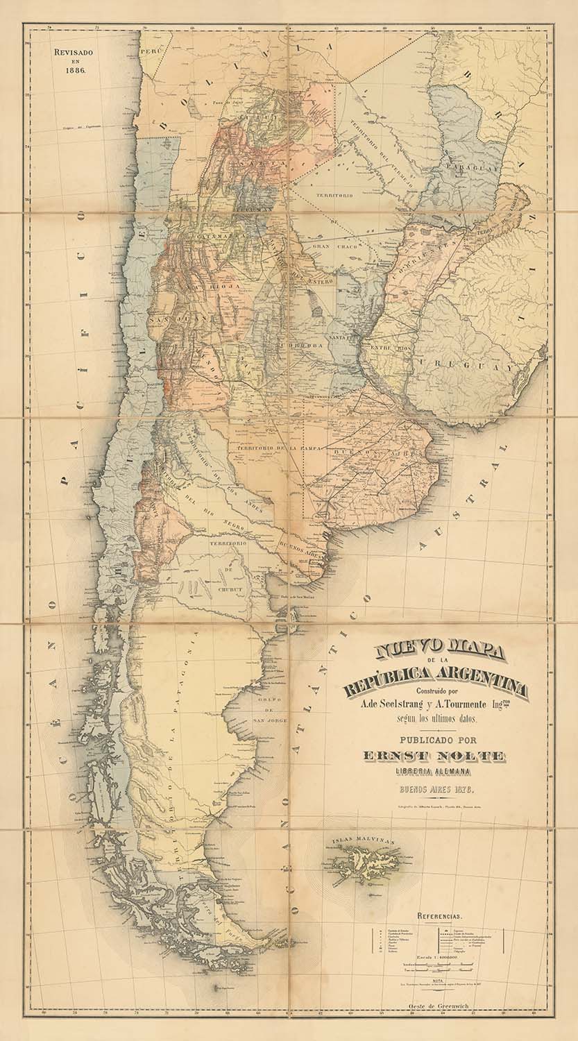
The "Nuevo Mapa de la República Argentina," crafted by the skilled hands of A. de Seelstrang and A. Tourmente and published by...
Continue readingThe "Nuevo Mapa de la República Argentina," crafted by the skilled hands of A. de Seelstrang and A. Tourmente and published by Ernst Nolte, is a remarkable cartographic achievement from 1886. This map captures a transformative period in Argentine history, when the nation was burgeoning with growth and European influence. It elegantly delineates the political and physical landscapes of Argentina and southern Chile, providing a window into a time when the country was expanding its territories and infrastructure. The map is a testament to Argentina's ambitions and its evolving identity as a nation of opportunity.
Ernst Nolte, the publisher, played a crucial role in bringing this detailed depiction to life. His work coincided with Argentina's post-civil war era, marked by the adoption of a new constitution in 1853 and the presidency of Domingo Faustino Sarmiento. Sarmiento's vision of integrating Argentina into the global economy is reflected in the map's meticulous illustration of railroads and telegraph lines, essential for trade and communication. Nolte's publication not only documented geographical changes but also mirrored the socio-economic shifts of the time.
The map beautifully captures the diverse geographical features of the region, from the majestic Andes Mountain Range to the expansive Atlantic and Pacific Oceans. It highlights the strategic Rio de la Plata, a vital waterway for trade and transport. The inset of Isla de los Estados adds a unique touch, offering further insight into the intricate geography of the area. These natural landmarks are more than just physical features; they are integral to understanding the historical and economic context of the late 19th century.
Cities and towns such as Buenos Aires, Córdoba, and Rosario are prominently marked, showcasing the urban growth and development spurred by European immigration. These settlements became melting pots of culture and innovation, driving Argentina's emergence as a major agricultural exporter. The map's depiction of these urban centers is a reflection of the vibrant, cosmopolitan society that was taking shape, enriched by the influx of European customs and traditions.
The "Nuevo Mapa de la República Argentina" is not just a map; it is a narrative of a nation's journey towards modernity and prosperity. It offers a rare glimpse into a pivotal era when Argentina was carving out its place on the world stage. This map is a collector's treasure, capturing the essence of a time when borders were redrawn, economies flourished, and a diverse cultural tapestry was woven across the land.
Cities and towns on this map
- Argentina
- Buenos Aires
- Córdoba
- Rosario
- Mendoza
- La Plata
- San Miguel de Tucumán
- Salta
-
Santa Fe
-
Chile
- Santiago
- Valparaíso
Notable Features & Landmarks
- Inset maps: Includes an inset of Isla de los Estados.
- Bodies of water: Atlantic Ocean, Pacific Ocean, Rio de la Plata.
- Borders: Borders with Chile and Uruguay are visible.
- Mountains: Andes Mountain Range is prominently depicted.
- Other features: Railroads and telegraph lines are marked.
Historical and design context
- Created during a period of significant growth and European immigration to Argentina.
- Reflects the expansion of Argentina during the "Conquest of the Desert."
- Illustrates the development of the railway network and telegraph lines, pivotal for trade and movement.
- Represents Argentina's transformation into a nation with a growing international presence.
- Highlights the impact of European immigration on agriculture and culture.
Please double check the images to make sure that a specific town or place is shown on this map. You can also get in touch and ask us to check the map for you.
This map looks great at every size, but I always recommend going for a larger size if you have space. That way you can easily make out all of the details.
This map looks amazing at sizes all the way up to 100in (250cm). If you are looking for a larger map, please get in touch.
The model in the listing images is holding the undefined version of this map.
The fifth listing image shows an example of my map personalisation service.
If you’re looking for something slightly different, check out my collection of the best old maps to see if something else catches your eye.
Please contact me to check if a certain location, landmark or feature is shown on this map.
This would make a wonderful birthday, Christmas, Father's Day, work leaving, anniversary or housewarming gift for someone from the areas covered by this map.
This map is available as a giclée print on acid free archival matte paper, or you can buy it framed. The frame is a nice, simple black frame that suits most aesthetics. Please get in touch if you'd like a different frame colour or material. My frames are glazed with super-clear museum-grade acrylic (perspex/acrylite), which is significantly less reflective than glass, safer, and will always arrive in perfect condition.
This map is also available as a float framed canvas, sometimes known as a shadow gap framed canvas or canvas floater. The map is printed on artist's cotton canvas and then stretched over a handmade box frame. We then "float" the canvas inside a wooden frame, which is available in a range of colours (black, dark brown, oak, antique gold and white). This is a wonderful way to present a map without glazing in front. See some examples of float framed canvas maps and explore the differences between my different finishes.
For something truly unique, this map is also available in "Unique 3D", our trademarked process that dramatically transforms the map so that it has a wonderful sense of depth. We combine the original map with detailed topography and elevation data, so that mountains and the terrain really "pop". For more info and examples of 3D maps, check my Unique 3D page.
The "Nuevo Mapa de la República Argentina," crafted by the skilled hands of A. de Seelstrang and A. Tourmente and published by Ernst Nolte, is a remarkable cartographic achievement from 1886. This map captures a transformative period in Argentine history, when the nation was burgeoning with growth and European influence. It elegantly delineates the political and physical landscapes of Argentina and southern Chile, providing a window into a time when the country was expanding its territories and infrastructure. The map is a testament to Argentina's ambitions and its evolving identity as a nation of opportunity.
Ernst Nolte, the publisher, played a crucial role in bringing this detailed depiction to life. His work coincided with Argentina's post-civil war era, marked by the adoption of a new constitution in 1853 and the presidency of Domingo Faustino Sarmiento. Sarmiento's vision of integrating Argentina into the global economy is reflected in the map's meticulous illustration of railroads and telegraph lines, essential for trade and communication. Nolte's publication not only documented geographical changes but also mirrored the socio-economic shifts of the time.
The map beautifully captures the diverse geographical features of the region, from the majestic Andes Mountain Range to the expansive Atlantic and Pacific Oceans. It highlights the strategic Rio de la Plata, a vital waterway for trade and transport. The inset of Isla de los Estados adds a unique touch, offering further insight into the intricate geography of the area. These natural landmarks are more than just physical features; they are integral to understanding the historical and economic context of the late 19th century.
Cities and towns such as Buenos Aires, Córdoba, and Rosario are prominently marked, showcasing the urban growth and development spurred by European immigration. These settlements became melting pots of culture and innovation, driving Argentina's emergence as a major agricultural exporter. The map's depiction of these urban centers is a reflection of the vibrant, cosmopolitan society that was taking shape, enriched by the influx of European customs and traditions.
The "Nuevo Mapa de la República Argentina" is not just a map; it is a narrative of a nation's journey towards modernity and prosperity. It offers a rare glimpse into a pivotal era when Argentina was carving out its place on the world stage. This map is a collector's treasure, capturing the essence of a time when borders were redrawn, economies flourished, and a diverse cultural tapestry was woven across the land.
Cities and towns on this map
- Argentina
- Buenos Aires
- Córdoba
- Rosario
- Mendoza
- La Plata
- San Miguel de Tucumán
- Salta
-
Santa Fe
-
Chile
- Santiago
- Valparaíso
Notable Features & Landmarks
- Inset maps: Includes an inset of Isla de los Estados.
- Bodies of water: Atlantic Ocean, Pacific Ocean, Rio de la Plata.
- Borders: Borders with Chile and Uruguay are visible.
- Mountains: Andes Mountain Range is prominently depicted.
- Other features: Railroads and telegraph lines are marked.
Historical and design context
- Created during a period of significant growth and European immigration to Argentina.
- Reflects the expansion of Argentina during the "Conquest of the Desert."
- Illustrates the development of the railway network and telegraph lines, pivotal for trade and movement.
- Represents Argentina's transformation into a nation with a growing international presence.
- Highlights the impact of European immigration on agriculture and culture.
Please double check the images to make sure that a specific town or place is shown on this map. You can also get in touch and ask us to check the map for you.
This map looks great at every size, but I always recommend going for a larger size if you have space. That way you can easily make out all of the details.
This map looks amazing at sizes all the way up to 100in (250cm). If you are looking for a larger map, please get in touch.
The model in the listing images is holding the undefined version of this map.
The fifth listing image shows an example of my map personalisation service.
If you’re looking for something slightly different, check out my collection of the best old maps to see if something else catches your eye.
Please contact me to check if a certain location, landmark or feature is shown on this map.
This would make a wonderful birthday, Christmas, Father's Day, work leaving, anniversary or housewarming gift for someone from the areas covered by this map.
This map is available as a giclée print on acid free archival matte paper, or you can buy it framed. The frame is a nice, simple black frame that suits most aesthetics. Please get in touch if you'd like a different frame colour or material. My frames are glazed with super-clear museum-grade acrylic (perspex/acrylite), which is significantly less reflective than glass, safer, and will always arrive in perfect condition.
This map is also available as a float framed canvas, sometimes known as a shadow gap framed canvas or canvas floater. The map is printed on artist's cotton canvas and then stretched over a handmade box frame. We then "float" the canvas inside a wooden frame, which is available in a range of colours (black, dark brown, oak, antique gold and white). This is a wonderful way to present a map without glazing in front. See some examples of float framed canvas maps and explore the differences between my different finishes.
For something truly unique, this map is also available in "Unique 3D", our trademarked process that dramatically transforms the map so that it has a wonderful sense of depth. We combine the original map with detailed topography and elevation data, so that mountains and the terrain really "pop". For more info and examples of 3D maps, check my Unique 3D page.
Many of our maps and art prints are chosen as thoughtful gifts for homes, offices, studies and meaningful places.
Choose a framed option for the easiest ready-to-hang gift, or choose an unframed print if the recipient may prefer to select their own frame.
We make orders locally in 23 countries around the world, so gifts can often be produced close to the recipient. This helps them arrive faster, travel more safely, and avoid customs or import duty surprises.
- We can deliver directly to the recipient
- Framed pieces arrive ready to hang
- Unframed prints are carefully packed in a strong protective tube
- Almost every order is made locally, for faster, safer gifting
- 90-day returns give the recipient time to decide
If you are not sure what to choose, please contact us. We can help you pick the right map, size, finish or delivery option.
Most orders are made locally and delivered in around 2–3 working days, depending on the product, size and destination.
We print and frame maps and artwork in 23 countries around the world, so your order is usually made close to you or your recipient. That means faster delivery, less time in transit, and no customs or import duty surprises.
Personalised and customised pieces usually take an extra 1–2 working days, because we prepare your design and send it to you for approval before printing.
Very large framed orders can take a little longer, as they need extra care in production and delivery.
Every order is carefully packaged: unframed prints are sent in a strong protective tube, while framed pieces are securely packed with protective materials around the frame.
If you need your order by a particular date, please contact us before ordering. We’ll check the best production route and delivery option for your location.
Express delivery is available at checkout for most countries. Next-day delivery is available in the UK, US, Singapore and the UAE.
Your order is covered by our 90-day returns policy and 10-year guarantee.
Our standard frame is a gallery-style black ash hardwood frame, with a simple, modern look. It is approximately 20mm (0.8in) wide. You can also view some lovely customer photos of framed maps and art.
We use super-clear acrylic glazing, also known as Perspex or Acrylite, instead of traditional glass. It is lighter, safer, and has lower reflectivity, giving the artwork a clearer, cleaner appearance.
Six standard frame colours are available at no extra cost: black, dark brown, dark grey, oak, white, and antique gold. Custom framing and mounting/matting is also available for customers looking for something more specific.
Most maps, art prints, and illustrations are also available as a framed canvas. We use matte cotton canvas, stretch it over a sustainably sourced wooden box frame, and then float the piece within a wooden outer frame. The finished result is beautifully presented, with no glazing between you and the artwork.
All frames are supplied ready to hang, with either string or brackets fitted to the back. Very large frames will include heavy-duty hanging plates and/or a mounting baton. If you have any questions, please get in touch.
We can also supply old maps and artwork on canvas, foam board, cotton rag, and other materials.
If you would prefer to frame your map or artwork yourself, please read our size guide before ordering.
My maps are extremely high quality reproductions of original maps.
I source original, rare maps from libraries, auction houses and private collections around the world, restore them at my London workshop, and then use specialist giclée inks and printers to create beautiful maps that look even better than the original.
My maps are printed on acid-free archival matte (not glossy) paper that feels very high quality and almost like card. In technical terms the paper weight/thickness is 10mil/200gsm. It's perfect for framing.
I print with Epson ultrachrome giclée UV fade resistant pigment inks - some of the best inks you can find.
I can also make maps on canvas, cotton rag and other exotic materials.
Learn more about The Unique Maps Co.
Map personalisation
If you're looking for the perfect anniversary or housewarming gift, I can personalise your map to make it truly unique. For example, I can add a short message, or highlight an important location, or add your family's coat of arms.
The options are almost infinite. Please see my map personalisation page for some wonderful examples of what's possible.
To order a personalised map, select "personalise your map" before adding it to your basket.
Get in touch if you're looking for more complex customisations and personalisations.
Map ageing
I have been asked hundreds of times over the years by customers if they could buy a map that looks even older.
Well, now you can, by selecting Aged before you add a map to your basket.
All the product photos you see on this page show the map in its Original form. This is what the map looks like today.
If you select Aged, I will age your map by hand, using a special and unique process developed through years of studying old maps, talking to researchers to understand the chemistry of aging paper, and of course... lots of practice!
If you're unsure, stick to the Original colour of the map. If you want something a bit darker and older looking, go for Aged.
If you are not happy with your order for any reason, contact me and I'll get it fixed ASAP, free of charge. Please see my returns and refund policy for more information.
I am very confident you will like your restored map or art print. I have been doing this since 1984. I'm a 5-star Etsy seller. I have sold tens of thousands of maps and art prints and have over 5,000 real 5-star reviews. My work has been featured in interior design magazines, on the BBC, and on the walls of dozens of 5-star hotels.
I use a unique process to restore maps and artwork that is massively time consuming and labour intensive. Hunting down the original maps and illustrations can take months. I use state of the art and eye-wateringly expensive technology to scan and restore them. As a result, I guarantee my maps and art prints are a cut above the rest. I stand by my products and will always make sure you're 100% happy with what you receive.
Almost all of my maps and art prints look amazing at large sizes (200cm, 6.5ft+) and I can frame and deliver them to you as well, via special oversized courier. Contact me to discuss your specific needs.
Or try searching for something!


