


Italy, boot of the Mediterranean, may prove Achilles Heel of Axis, 1942: WW2 Allied Strategy Map
The Collector’s Offer
Choose two eligible works and receive 20% off both. Choose three and the lowest-priced one is complimentary, a maximum saving of 33%.
Mix and match eligible standard maps and fine-art prints. No code is required; the offer is applied automatically at checkout.
Standard made-to-order configurations are included. Bespoke sizes, personalised designs and commissioned work are excluded.
Need delivery to different addresses? Contact us before ordering.The Collector’s Offer
Choose two eligible works and receive 20% off both. Choose three and the lowest-priced one is complimentary, a maximum saving of 33%.
Mix and match eligible standard maps and fine-art prints. No code is required; the offer is applied automatically at checkout.
Standard made-to-order configurations are included. Bespoke sizes, personalised designs and commissioned work are excluded.
Need delivery to different addresses? Contact us before ordering. Designed in London Made in the EU
Designed in London • Made in the EU
Designed in London Made in the EU
Designed in London • Made in the EU

Restored from the original 1942 map and printed to museum-grade archival standards. Read the story behind this map
Choose your size
Choose your finish


(More info)
Gift message & custom finish

If you want to add a gift message, or a finish (jigsaw, aluminium board, etc.) that is not available here, please request it in the "order note" when you check out.
Every order is custom made, so if you need the size adjusted slightly, or printed on an unusual material, just let us know. We've done thousands of custom orders over the years, so there's (almost) nothing we can't manage.
You can also contact us before you order, if you prefer!

- Made locally for fast, safe delivery
- No import duty or hidden fees
- Need advice? Call us or message on WhatsApp
Own a piece of history
8,000+ five-star reviews


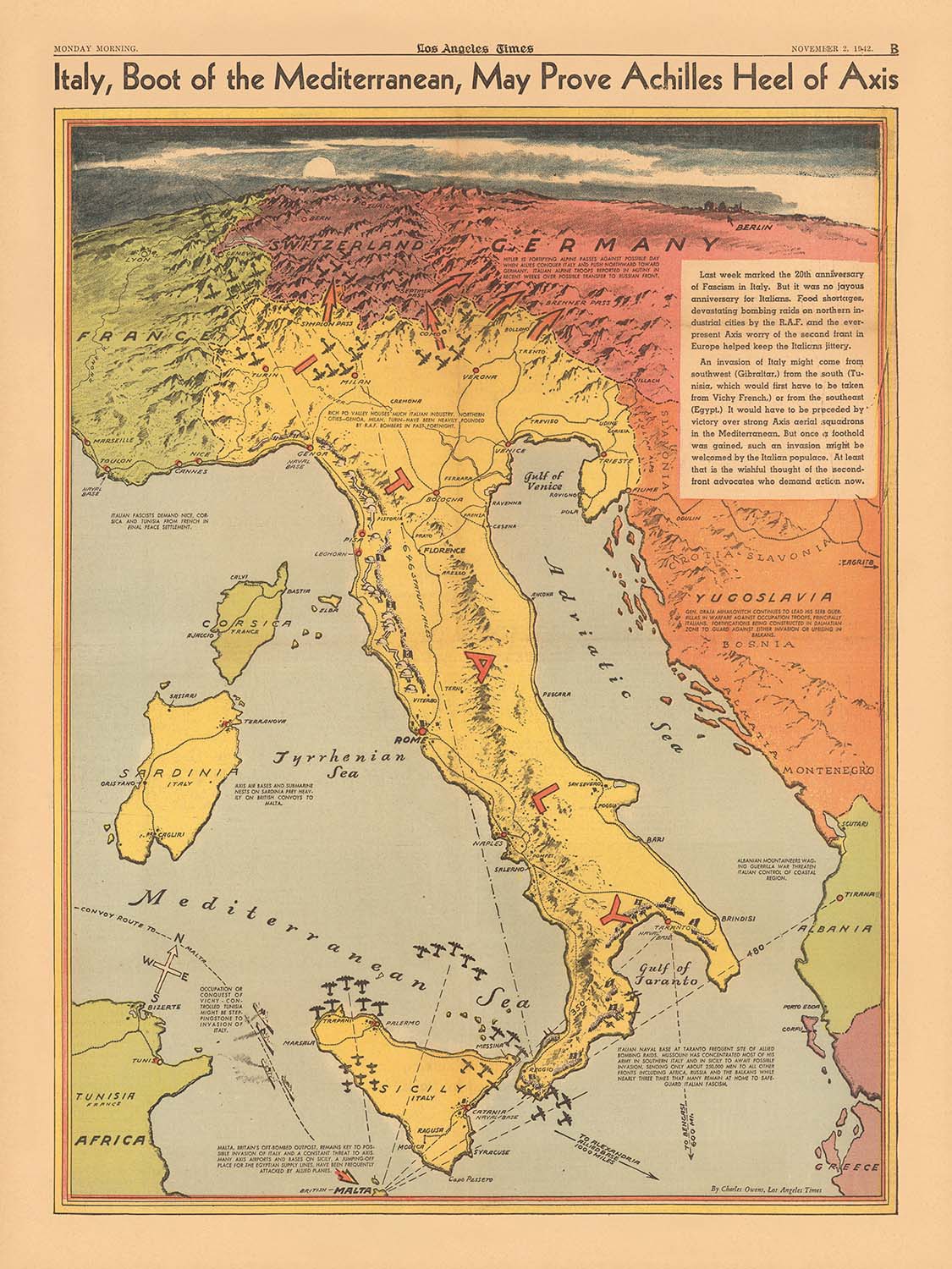
Step into the pivotal moments of World War II with this remarkable 1942 map, “Italy, boot of the Mediterranean, may prove Achilles...
Continue readingStep into the pivotal moments of World War II with this remarkable 1942 map, “Italy, boot of the Mediterranean, may prove Achilles Heel of Axis,” masterfully crafted by Charles Owens for the Los Angeles Times. This map is more than a geographical depiction—it is a vibrant, historically charged document that captures the tense atmosphere and strategic calculations of the era. Designed at a critical juncture in the war, it reflects Allied hopes and anxieties as they eyed Italy’s unique geography as a potential vulnerability in the Axis powers’ defenses.
The map’s thematic focus on military strategy is immediately evident in its detailed illustration of Allied convoy routes and aerial attack lines radiating from the vital British base on Malta. These routes crisscross the Mediterranean, converging on key Axis strongholds and highlighting the logistical lifelines that sustained the war effort. The inclusion of annotated distances between strategic locations, such as from Malta to Sicily or North Africa, provides a tangible sense of the operational challenges and opportunities faced by Allied commanders.
Pictorial relief and vivid colorwork bring the terrain of Italy and its surrounding regions to life, emphasizing the dramatic topography that shaped military campaigns. The “boot” of Italy, flanked by the islands of Sicily, Sardinia, and Corsica, is rendered with both artistic flair and cartographic precision. Major cities like Rome, Naples, and Palermo are prominently labeled, alongside crucial railroads, ports, and military bases, underscoring the importance of infrastructure in wartime logistics and movement.
This map is rich with historical notes and explanatory text, offering contemporary insights into the unfolding conflict. The title itself, invoking the myth of Achilles’ heel, frames Italy’s position as both a strength and a potential fatal weakness for the Axis. The map’s narrative elements and clear visual storytelling were designed to inform and rally the American public, making it a compelling example of wartime journalism and propaganda.
Historically, this map stands as a testament to the strategic turning points of 1942, when Allied forces were gaining momentum in North Africa and preparing for the eventual invasion of southern Europe. It encapsulates the anxieties, hopes, and calculated risks of the time, providing a window into the mindset of military planners and the broader public. As a piece of both art and history, this map offers collectors and enthusiasts a unique opportunity to own a tangible artifact from one of the most consequential periods of the twentieth century.
Places on this map
- Rome
- Naples
- Palermo
- Genoa
- Milan
- Venice
- Florence
- Turin
- Bari
- Taranto
- Trieste
- Malta
- Cagliari (Sardinia)
- Catania (Sicily)
- Messina (Sicily)
- Tripoli (Libya)
- Tobruk (Libya)
- Tunis (Tunisia)
- Algiers (Algeria)
- Alexandria (Egypt)
Notable Features & Landmarks
- The "boot" shape of Italy prominently depicted, emphasizing its strategic position in the Mediterranean
- Allied convoy routes across the Mediterranean Sea, especially from Gibraltar and Alexandria toward Malta and North Africa
- Lines of aerial attack originating from Malta, showing Allied air operations targeting Axis supply lines and positions
- Sicily and Sardinia, with strategic locations and cities marked
- Corsica, shown to the northwest of Italy
- North African coast, with key locations such as Tripoli and Tobruk
- Railroads and transportation lines within Italy, indicating their importance for military logistics
- Forts and military bases along the Italian coast and islands
- Pictorial relief (mountains and hills), providing a sense of the terrain
- Distances between strategic points (e.g., from Malta to Sicily or North Africa) annotated
- Textual notes explaining the importance of certain routes or locations
- Allied and Axis naval and air bases marked
- The Strait of Messina, a narrow passage between Sicily and mainland Italy, highlighted
- The Tyrrhenian, Adriatic, and Ionian Seas labeled
- Arrows and symbols indicating directions of movement and attacks
- Insets or side notes with historical context about recent battles or ongoing campaigns
- Key Mediterranean ports, such as Genoa, Naples, and Palermo, highlighted for their strategic value
- Annotations about the vulnerability of Italian supply lines
- The Suez Canal and Gibraltar, shown at the periphery as major points controlling access to the Mediterranean
- The "Achilles Heel" metaphor visually reinforced by the map’s layout and labeling
- Allied and Axis flags or insignia used to denote control of specific areas
- Date and publisher information displayed in the map’s legend or margin
- Explanatory text boxes summarizing recent military developments
- Shaded or colored areas to denote regions under Axis or Allied control
- Important battle sites, such as El Alamein in North Africa, referenced or shown
- The map’s legend explaining symbols and color coding
Historical and design context
- Created by Charles Owens and published by the Los Angeles Times on November 2, 1942
- Designed at a pivotal moment in World War II, reflecting Allied strategic thinking as they targeted Italy’s geographic vulnerabilities
- Combines military, geographic, and contextual information in a historically informative thematic and pictorial style
- Uses bold colors, pictorial elements, and clear labels to make complex military information accessible to a general audience
- Includes textual explanations and historical notes to provide context for non-expert readers
- Reflects the style of wartime journalism and information graphics of the early 1940s
- Intended to inform and rally the American public by highlighting Allied strategies and Axis vulnerabilities
- Offers insight into the operational challenges and opportunities faced by Allied commanders during the Mediterranean campaign
- Serves as both a cartographic resource and an informative historical document from one of the most consequential periods of the twentieth century
Please double check the images to make sure that a specific town or place is shown on this map. You can also get in touch and ask us to check the map for you.
This map looks great at every size, but I always recommend going for a larger size if you have space. That way you can easily make out all of the details.
This map looks amazing at sizes all the way up to 70in (180cm). If you are looking for a larger map, please get in touch.
The model in the listing images is holding the 18x24in (45x60cm) version of this map.
The fifth listing image shows an example of my map personalisation service.
If you’re looking for something slightly different, check out my collection of the best old maps to see if something else catches your eye.
Please contact me to check if a certain location, landmark or feature is shown on this map.
This would make a wonderful birthday, Christmas, Father's Day, work leaving, anniversary or housewarming gift for someone from the areas covered by this map.
This map is available as a giclée print on acid free archival matte paper, or you can buy it framed. The frame is a nice, simple black frame that suits most aesthetics. Please get in touch if you'd like a different frame colour or material. My frames are glazed with super-clear museum-grade acrylic (perspex/acrylite), which is significantly less reflective than glass, safer, and will always arrive in perfect condition.
This map is also available as a float framed canvas, sometimes known as a shadow gap framed canvas or canvas floater. The map is printed on artist's cotton canvas and then stretched over a handmade box frame. We then "float" the canvas inside a wooden frame, which is available in a range of colours (black, dark brown, oak, antique gold and white). This is a wonderful way to present a map without glazing in front. See some examples of float framed canvas maps and explore the differences between my different finishes.
For something truly unique, this map is also available in "Unique 3D", our trademarked process that dramatically transforms the map so that it has a wonderful sense of depth. We combine the original map with detailed topography and elevation data, so that mountains and the terrain really "pop". For more info and examples of 3D maps, check my Unique 3D page.
Step into the pivotal moments of World War II with this remarkable 1942 map, “Italy, boot of the Mediterranean, may prove Achilles Heel of Axis,” masterfully crafted by Charles Owens for the Los Angeles Times. This map is more than a geographical depiction—it is a vibrant, historically charged document that captures the tense atmosphere and strategic calculations of the era. Designed at a critical juncture in the war, it reflects Allied hopes and anxieties as they eyed Italy’s unique geography as a potential vulnerability in the Axis powers’ defenses.
The map’s thematic focus on military strategy is immediately evident in its detailed illustration of Allied convoy routes and aerial attack lines radiating from the vital British base on Malta. These routes crisscross the Mediterranean, converging on key Axis strongholds and highlighting the logistical lifelines that sustained the war effort. The inclusion of annotated distances between strategic locations, such as from Malta to Sicily or North Africa, provides a tangible sense of the operational challenges and opportunities faced by Allied commanders.
Pictorial relief and vivid colorwork bring the terrain of Italy and its surrounding regions to life, emphasizing the dramatic topography that shaped military campaigns. The “boot” of Italy, flanked by the islands of Sicily, Sardinia, and Corsica, is rendered with both artistic flair and cartographic precision. Major cities like Rome, Naples, and Palermo are prominently labeled, alongside crucial railroads, ports, and military bases, underscoring the importance of infrastructure in wartime logistics and movement.
This map is rich with historical notes and explanatory text, offering contemporary insights into the unfolding conflict. The title itself, invoking the myth of Achilles’ heel, frames Italy’s position as both a strength and a potential fatal weakness for the Axis. The map’s narrative elements and clear visual storytelling were designed to inform and rally the American public, making it a compelling example of wartime journalism and propaganda.
Historically, this map stands as a testament to the strategic turning points of 1942, when Allied forces were gaining momentum in North Africa and preparing for the eventual invasion of southern Europe. It encapsulates the anxieties, hopes, and calculated risks of the time, providing a window into the mindset of military planners and the broader public. As a piece of both art and history, this map offers collectors and enthusiasts a unique opportunity to own a tangible artifact from one of the most consequential periods of the twentieth century.
Places on this map
- Rome
- Naples
- Palermo
- Genoa
- Milan
- Venice
- Florence
- Turin
- Bari
- Taranto
- Trieste
- Malta
- Cagliari (Sardinia)
- Catania (Sicily)
- Messina (Sicily)
- Tripoli (Libya)
- Tobruk (Libya)
- Tunis (Tunisia)
- Algiers (Algeria)
- Alexandria (Egypt)
Notable Features & Landmarks
- The "boot" shape of Italy prominently depicted, emphasizing its strategic position in the Mediterranean
- Allied convoy routes across the Mediterranean Sea, especially from Gibraltar and Alexandria toward Malta and North Africa
- Lines of aerial attack originating from Malta, showing Allied air operations targeting Axis supply lines and positions
- Sicily and Sardinia, with strategic locations and cities marked
- Corsica, shown to the northwest of Italy
- North African coast, with key locations such as Tripoli and Tobruk
- Railroads and transportation lines within Italy, indicating their importance for military logistics
- Forts and military bases along the Italian coast and islands
- Pictorial relief (mountains and hills), providing a sense of the terrain
- Distances between strategic points (e.g., from Malta to Sicily or North Africa) annotated
- Textual notes explaining the importance of certain routes or locations
- Allied and Axis naval and air bases marked
- The Strait of Messina, a narrow passage between Sicily and mainland Italy, highlighted
- The Tyrrhenian, Adriatic, and Ionian Seas labeled
- Arrows and symbols indicating directions of movement and attacks
- Insets or side notes with historical context about recent battles or ongoing campaigns
- Key Mediterranean ports, such as Genoa, Naples, and Palermo, highlighted for their strategic value
- Annotations about the vulnerability of Italian supply lines
- The Suez Canal and Gibraltar, shown at the periphery as major points controlling access to the Mediterranean
- The "Achilles Heel" metaphor visually reinforced by the map’s layout and labeling
- Allied and Axis flags or insignia used to denote control of specific areas
- Date and publisher information displayed in the map’s legend or margin
- Explanatory text boxes summarizing recent military developments
- Shaded or colored areas to denote regions under Axis or Allied control
- Important battle sites, such as El Alamein in North Africa, referenced or shown
- The map’s legend explaining symbols and color coding
Historical and design context
- Created by Charles Owens and published by the Los Angeles Times on November 2, 1942
- Designed at a pivotal moment in World War II, reflecting Allied strategic thinking as they targeted Italy’s geographic vulnerabilities
- Combines military, geographic, and contextual information in a historically informative thematic and pictorial style
- Uses bold colors, pictorial elements, and clear labels to make complex military information accessible to a general audience
- Includes textual explanations and historical notes to provide context for non-expert readers
- Reflects the style of wartime journalism and information graphics of the early 1940s
- Intended to inform and rally the American public by highlighting Allied strategies and Axis vulnerabilities
- Offers insight into the operational challenges and opportunities faced by Allied commanders during the Mediterranean campaign
- Serves as both a cartographic resource and an informative historical document from one of the most consequential periods of the twentieth century
Please double check the images to make sure that a specific town or place is shown on this map. You can also get in touch and ask us to check the map for you.
This map looks great at every size, but I always recommend going for a larger size if you have space. That way you can easily make out all of the details.
This map looks amazing at sizes all the way up to 70in (180cm). If you are looking for a larger map, please get in touch.
The model in the listing images is holding the 18x24in (45x60cm) version of this map.
The fifth listing image shows an example of my map personalisation service.
If you’re looking for something slightly different, check out my collection of the best old maps to see if something else catches your eye.
Please contact me to check if a certain location, landmark or feature is shown on this map.
This would make a wonderful birthday, Christmas, Father's Day, work leaving, anniversary or housewarming gift for someone from the areas covered by this map.
This map is available as a giclée print on acid free archival matte paper, or you can buy it framed. The frame is a nice, simple black frame that suits most aesthetics. Please get in touch if you'd like a different frame colour or material. My frames are glazed with super-clear museum-grade acrylic (perspex/acrylite), which is significantly less reflective than glass, safer, and will always arrive in perfect condition.
This map is also available as a float framed canvas, sometimes known as a shadow gap framed canvas or canvas floater. The map is printed on artist's cotton canvas and then stretched over a handmade box frame. We then "float" the canvas inside a wooden frame, which is available in a range of colours (black, dark brown, oak, antique gold and white). This is a wonderful way to present a map without glazing in front. See some examples of float framed canvas maps and explore the differences between my different finishes.
For something truly unique, this map is also available in "Unique 3D", our trademarked process that dramatically transforms the map so that it has a wonderful sense of depth. We combine the original map with detailed topography and elevation data, so that mountains and the terrain really "pop". For more info and examples of 3D maps, check my Unique 3D page.
Many of our maps and art prints are chosen as thoughtful gifts for homes, offices, studies and meaningful places.
Choose a framed option for the easiest ready-to-hang gift, or choose an unframed print if the recipient may prefer to select their own frame.
We make orders locally in 23 countries around the world, so gifts can often be produced close to the recipient. This helps them arrive faster, travel more safely, and avoid customs or import duty surprises.
- We can deliver directly to the recipient
- Framed pieces arrive ready to hang
- Unframed prints are carefully packed in a strong protective tube
- Almost every order is made locally, for faster, safer gifting
- 90-day returns give the recipient time to decide
If you are not sure what to choose, please contact us. We can help you pick the right map, size, finish or delivery option.
Most orders are made locally and delivered in around 2–3 working days, depending on the product, size and destination.
We print and frame maps and artwork in 23 countries around the world, so your order is usually made close to you or your recipient. That means faster delivery, less time in transit, and no customs or import duty surprises.
Personalised and customised pieces usually take an extra 1–2 working days, because we prepare your design and send it to you for approval before printing.
Very large framed orders can take a little longer, as they need extra care in production and delivery.
Every order is carefully packaged: unframed prints are sent in a strong protective tube, while framed pieces are securely packed with protective materials around the frame.
If you need your order by a particular date, please contact us before ordering. We’ll check the best production route and delivery option for your location.
Express delivery is available at checkout for most countries. Next-day delivery is available in the UK, US, Singapore and the UAE.
Your order is covered by our 90-day returns policy and 10-year guarantee.
Our standard frame is a gallery-style black ash hardwood frame, with a simple, modern look. It is approximately 20mm (0.8in) wide. You can also view some lovely customer photos of framed maps and art.
We use super-clear acrylic glazing, also known as Perspex or Acrylite, instead of traditional glass. It is lighter, safer, and has lower reflectivity, giving the artwork a clearer, cleaner appearance.
Six standard frame colours are available at no extra cost: black, dark brown, dark grey, oak, white, and antique gold. Custom framing and mounting/matting is also available for customers looking for something more specific.
Most maps, art prints, and illustrations are also available as a framed canvas. We use matte cotton canvas, stretch it over a sustainably sourced wooden box frame, and then float the piece within a wooden outer frame. The finished result is beautifully presented, with no glazing between you and the artwork.
All frames are supplied ready to hang, with either string or brackets fitted to the back. Very large frames will include heavy-duty hanging plates and/or a mounting baton. If you have any questions, please get in touch.
We can also supply old maps and artwork on canvas, foam board, cotton rag, and other materials.
If you would prefer to frame your map or artwork yourself, please read our size guide before ordering.
My maps are extremely high quality reproductions of original maps.
I source original, rare maps from libraries, auction houses and private collections around the world, restore them at my London workshop, and then use specialist giclée inks and printers to create beautiful maps that look even better than the original.
My maps are printed on acid-free archival matte (not glossy) paper that feels very high quality and almost like card. In technical terms the paper weight/thickness is 10mil/200gsm. It's perfect for framing.
I print with Epson ultrachrome giclée UV fade resistant pigment inks - some of the best inks you can find.
I can also make maps on canvas, cotton rag and other exotic materials.
Learn more about The Unique Maps Co.
Map personalisation
If you're looking for the perfect anniversary or housewarming gift, I can personalise your map to make it truly unique. For example, I can add a short message, or highlight an important location, or add your family's coat of arms.
The options are almost infinite. Please see my map personalisation page for some wonderful examples of what's possible.
To order a personalised map, select "personalise your map" before adding it to your basket.
Get in touch if you're looking for more complex customisations and personalisations.
Map ageing
I have been asked hundreds of times over the years by customers if they could buy a map that looks even older.
Well, now you can, by selecting Aged before you add a map to your basket.
All the product photos you see on this page show the map in its Original form. This is what the map looks like today.
If you select Aged, I will age your map by hand, using a special and unique process developed through years of studying old maps, talking to researchers to understand the chemistry of aging paper, and of course... lots of practice!
If you're unsure, stick to the Original colour of the map. If you want something a bit darker and older looking, go for Aged.
If you are not happy with your order for any reason, contact me and I'll get it fixed ASAP, free of charge. Please see my returns and refund policy for more information.
I am very confident you will like your restored map or art print. I have been doing this since 1984. I'm a 5-star Etsy seller. I have sold tens of thousands of maps and art prints and have over 5,000 real 5-star reviews. My work has been featured in interior design magazines, on the BBC, and on the walls of dozens of 5-star hotels.
I use a unique process to restore maps and artwork that is massively time consuming and labour intensive. Hunting down the original maps and illustrations can take months. I use state of the art and eye-wateringly expensive technology to scan and restore them. As a result, I guarantee my maps and art prints are a cut above the rest. I stand by my products and will always make sure you're 100% happy with what you receive.
Almost all of my maps and art prints look amazing at large sizes (200cm, 6.5ft+) and I can frame and deliver them to you as well, via special oversized courier. Contact me to discuss your specific needs.
Or try searching for something!


