


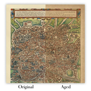


Old Bird's-eye Map of Marseille by Orlandi, 1580: Notre Dame, La Major, S. Laurent, Port, Arsenal

-
![]() Handmade locally in the EU
Handmade locally in the EU
-
FREE worldwide delivery in 2-3 days ⓘ
Free delivery in 2-3 days
Your map should be delivered in 2-3 working days with free delivery, worldwide.
We make maps by hand locally in 23 countries, including the EU
![]() . If you're buying a gift for someone in another country, we will make the map locally to them.
. If you're buying a gift for someone in another country, we will make the map locally to them.You will never pay import tax or customs duty.
Express delivery is available at checkout which can reduce the delivery time to 1-2 days.
Please note that personalised maps, and larger framed maps, can take longer to produce and deliver.
If you need your order to arrive by a certain date, contact me and we can discuss your options.
-
90 day money back guarantee
ⓘ
90 days to return and refund
Products can be returned within 90 days for a full refund, or exchange for another product.
For personalised or custom made items, we may offer you store credit or a non-expiring gift card, as we cannot resell personalised orders.
If you have any questions, get in touch. For more information, see our full returns & exchanges policy.

My maps are rare, museum-grade, restored old maps sourced from libraries, auction houses and private collections across the globe.
Framing & free personalisation available
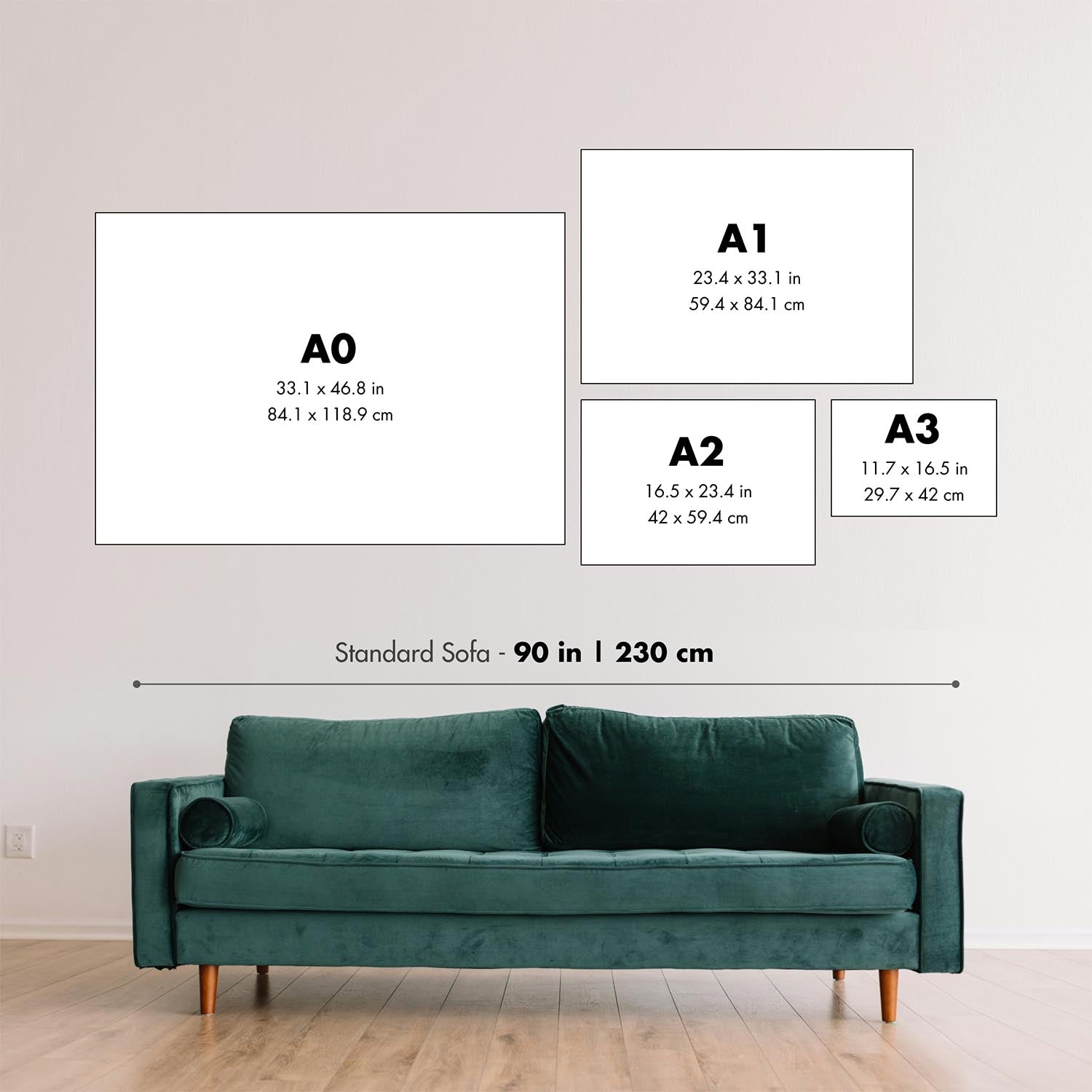
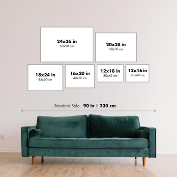
1. Select your size
2. Frame & personalise your map
Make your map unique with framing, hand-drawn customisation, vintage ageing, pop art text, unique 3D styling and moreGift message & custom finish

If you want to add a gift message, or a finish (jigsaw, aluminium board, etc.) that is not available here, please request it in the "order note" when you check out.
Every order is custom made, so if you need the size adjusted slightly, or printed on an unusual material, just let us know. We've done thousands of custom orders over the years, so there's (almost) nothing we can't manage.
You can also contact us before you order, if you prefer!

- Handmade locally. No import duty or tax
- FREE Delivery. Arrives in 2-3 days
- Love it or your money back
- Questions? WhatsApp me any time
Own a piece of history
5,000+ 5 star reviews


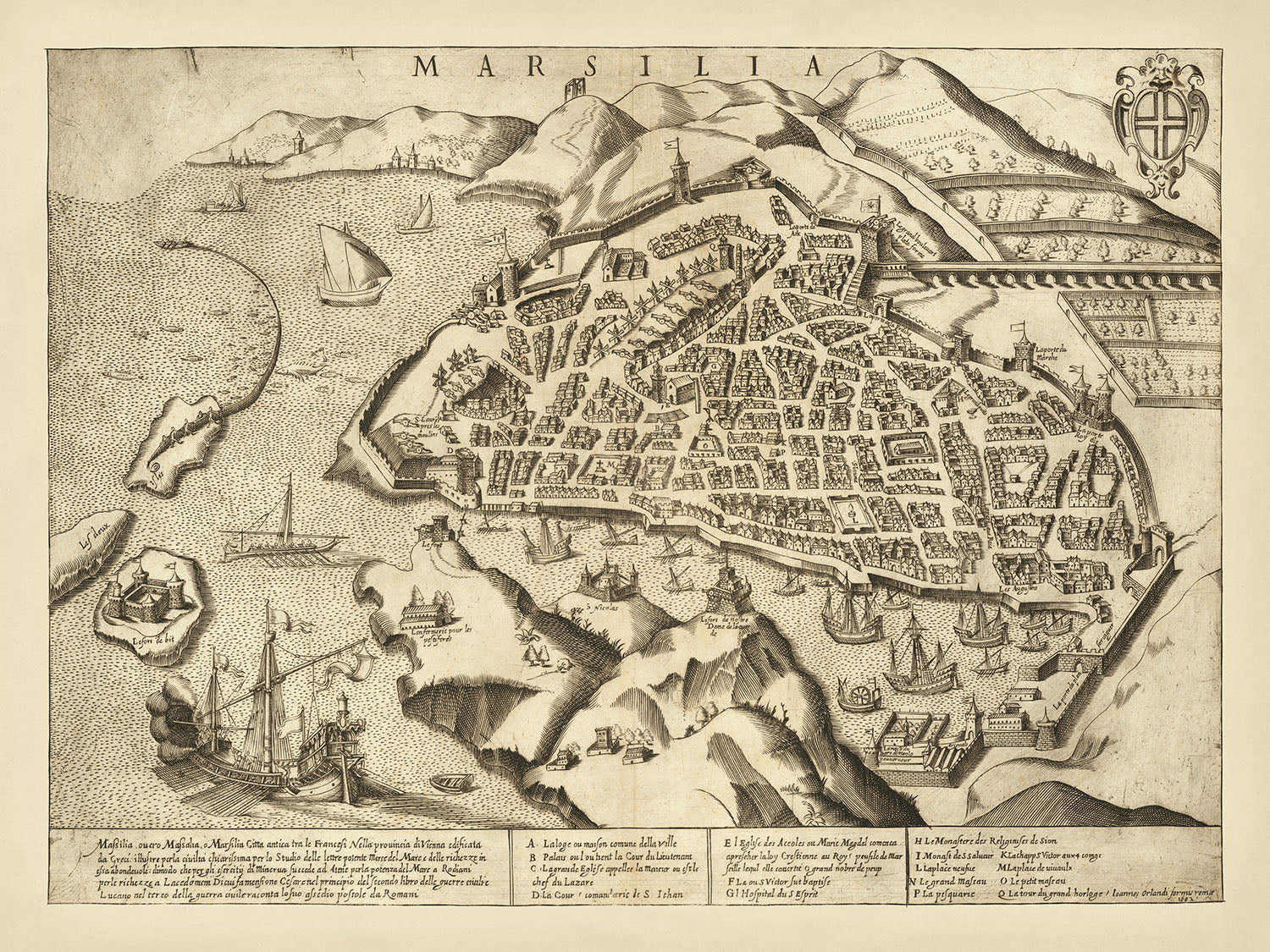
The map titled "Marsilia," created in 1580, offers a captivating bird's-eye view of the historic city of Marseille. This exquisite piece, initially published anonymously and later by Giovanni Orlandi, presents a rich tapestry of the city's vibrant life and significant landmarks. The map's detailed depiction from above "Le Fort de Notre Dame de la Garde" provides a unique perspective, showcasing the intricate layout of Marseille's streets, fortifications, and bustling harbor. The inclusion of the city's coat of arms and a descriptive Italian text further enriches its historical value, making it a prized artifact for collectors and history enthusiasts alike.
Marseille, a city of profound historical significance, is brought to life through this map. The text description at the bottom right narrates the city's storied past, from its founding by the Greeks to its siege by the Romans in the third century. Known as a hub of Letters, Merchants, and Sailors, Marseille's economic and cultural prominence is vividly illustrated. The map's key identifies 16 points of interest, guiding the viewer through notable landmarks such as Le Fort de Notre Dame de la Garde, the cathedral of La Major, and the bustling port, each a testament to the city's enduring legacy.
The map's pictorial style is not only visually appealing but also functionally informative. Ships dotting the harbor, fortifications encircling the city, and various buildings and structures are meticulously illustrated, providing a snapshot of 16th-century Marseille. The detailed depiction of residential and commercial neighborhoods offers insight into the city's urban planning and daily life. Open spaces and gardens interspersed within the city's layout highlight the blend of natural beauty and architectural grandeur that defines Marseille.
Giovanni Orlandi, the publisher of this map, was a renowned Italian engraver and publisher active in the late 16th and early 17th centuries. His work is celebrated for its artistic detail and historical accuracy, and this map of Marseille is no exception. Orlandi's ability to capture the essence of the city through intricate engravings and descriptive texts has cemented his reputation as a master cartographer. The rarity of this map, with only a few known examples in existence, adds to its allure and value.
This map of Marseille is more than just a visual representation; it is a historical document that offers a window into the past. The city's rich history, from its ancient Greek origins to its strategic importance in the Roman era, is encapsulated in this detailed illustration. For collectors, historians, and admirers of fine cartography, this map is a treasure trove of information and a testament to the enduring legacy of one of France's most significant cities.
Streets and roads on this map
- A. Lodgo ou maison commune
- B. Palais ou maison de la court de Parliament
- C. L'Archevesque
- D. La cathedrale de la Major
- E. L'eglise des Accoules ou Marie Magdelainne
- F. L'eglise de S. Laurent
- G. L'Hospital de la S. Esprit
- H. Le Monastere des Religieuses de S. Iean
- I. Monastere des Religieux de S. Victor
- L. Logement du Roy
- M. Magasin ou arsenal
- N. L'arsenal des galleres
- O. Le port neuf
- P. La Iurence
- Q. La tour de S. Iean et Bourgoyne
Notable Features & Landmarks
- Illustrations:
- Ships in the harbor
- Various buildings and structures
- Fortifications around the city
- Landmarks:
- Le Fort de Notre Dame de la Garde
- The coat of arms of Marseille
- Neighbourhoods:
- Various residential and commercial areas are depicted throughout the city.
- Lakes:
- A small body of water or lake is depicted within the city's bounds.
- Large parks:
- There are open spaces and gardens depicted within the city.
- Other notable features:
- Detailed key identifying 16 points of interest within the city
- Historical text description in Italian
Historical and design context
- Name of the map: [Marseille] Marsilia
- Creation date: 1580
- Mapmaker/Publisher: Anonymous, later editions by Giovanni Orlandi and Hendrik van Schoel in Rome
- Interesting context about the mapmaker: Giovanni Orlandi was an Italian engraver and publisher active in the late 16th and early 17th centuries. He is known for his detailed and artistic maps.
- Topics and themes shown on the map:
- Bird's-eye view: The map offers a bird's-eye view of Marseille, providing a detailed and comprehensive layout of the city as seen from above "Le Fort de Notre Dame de la Garde."
- Historical significance: The map includes a text description in Italian detailing the history of Marseille, from its founding by the Greeks to its siege by the Romans in the third century.
- Key points of interest: A key identifying 16 points of interest within the city.
- Countries and regions shown on the map: The map focuses on the city of Marseille, France.
- Design or style of the map:
- Pictorial map: The map is a pictorial representation, offering a visual narrative of the city's layout and significant landmarks.
- Coat of arms: The map includes the coat of arms of the city of Marseille.
- Text description: An Italian text description at the bottom right, detailing the rich history and significance of Marseille.
- Historical significance or context of the map:
- Rarity: The map is extremely rare, with the first state known in a single example, the second state in 2 examples, and the first and third states each known in 1 example.
- Cultural and economic significance: Marseille is described as a rich and powerful city of Letters, Merchants, and Sailors.
Please double check the images to make sure that a specific town or place is shown on this map. You can also get in touch and ask us to check the map for you.
This map looks great at every size, but I always recommend going for a larger size if you have space. That way you can easily make out all of the details.
This map looks amazing at sizes all the way up to 90in (230cm). If you are looking for a larger map, please get in touch.
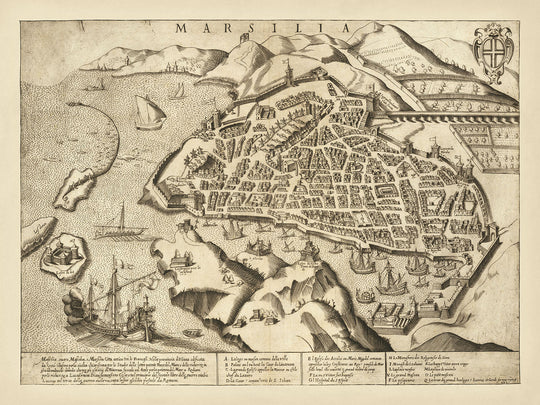
The model in the listing images is holding the 18x24in (45x60cm) version of this map.
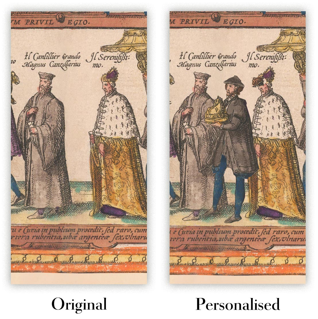
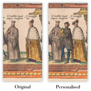
The fifth listing image shows an example of my map personalisation service.
If you’re looking for something slightly different, check out my collection of the best old maps to see if something else catches your eye.
Please contact me to check if a certain location, landmark or feature is shown on this map.
This would make a wonderful birthday, Christmas, Father's Day, work leaving, anniversary or housewarming gift for someone from the areas covered by this map.
This map is available as a giclée print on acid free archival matte paper, or you can buy it framed. The frame is a nice, simple black frame that suits most aesthetics. Please get in touch if you'd like a different frame colour or material. My frames are glazed with super-clear museum-grade acrylic (perspex/acrylite), which is significantly less reflective than glass, safer, and will always arrive in perfect condition.
This map is also available as a float framed canvas, sometimes known as a shadow gap framed canvas or canvas floater. The map is printed on artist's cotton canvas and then stretched over a handmade box frame. We then "float" the canvas inside a wooden frame, which is available in a range of colours (black, dark brown, oak, antique gold and white). This is a wonderful way to present a map without glazing in front. See some examples of float framed canvas maps and explore the differences between my different finishes.
For something truly unique, this map is also available in "Unique 3D", our trademarked process that dramatically transforms the map so that it has a wonderful sense of depth. We combine the original map with detailed topography and elevation data, so that mountains and the terrain really "pop". For more info and examples of 3D maps, check my Unique 3D page.
For most orders, delivery time is about 3 working days. Personalised and customised products take longer, as I have to do the personalisation and send it to you for approval, which usually takes 1 or 2 days.
Please note that very large framed orders usually take longer to make and deliver.
If you need your order to arrive by a certain date, please contact me before you order so that we can find the best way of making sure you get your order in time.
I print and frame maps and artwork in 23 countries around the world. This means your order will be made locally, which cuts down on delivery time and ensures that it won't be damaged during delivery. You'll never pay customs or import duty, and we'll put less CO2 into the air.
All of my maps and art prints are well packaged and sent in a rugged tube if unframed, or surrounded by foam if framed.
I try to send out all orders within 1 or 2 days of receiving your order, though some products (like face masks, mugs and tote bags) can take longer to make.
If you select Express Delivery at checkout your order we will prioritise your order and send it out by 1-day courier (Fedex, DHL, UPS, Parcelforce).
Next Day delivery is also available in some countries (US, UK, Singapore, UAE) but please try to order early in the day so that we can get it sent out on time.
My standard frame is a gallery style black ash hardwood frame. It is simple and quite modern looking. My standard frame is around 20mm (0.8in) wide.
I use super-clear acrylic (perspex/acrylite) for the frame glass. It's lighter and safer than glass - and it looks better, as the reflectivity is lower.
Six standard frame colours are available for free (black, dark brown, dark grey, oak, white and antique gold). Custom framing and mounting/matting is available if you're looking for something else.
Most maps, art and illustrations are also available as a framed canvas. We use matte (not shiny) cotton canvas, stretch it over a sustainably sourced box wood frame, and then 'float' the piece within a wood frame. The end result is quite beautiful, and there's no glazing to get in the way.
All frames are provided "ready to hang", with either a string or brackets on the back. Very large frames will have heavy duty hanging plates and/or a mounting baton. If you have any questions, please get in touch.
See some examples of my framed maps and framed canvas maps.
Alternatively, I can also supply old maps and artwork on canvas, foam board, cotton rag and other materials.
If you want to frame your map or artwork yourself, please read my size guide first.
My maps are extremely high quality reproductions of original maps.
I source original, rare maps from libraries, auction houses and private collections around the world, restore them at my London workshop, and then use specialist giclée inks and printers to create beautiful maps that look even better than the original.
My maps are printed on acid-free archival matte (not glossy) paper that feels very high quality and almost like card. In technical terms the paper weight/thickness is 10mil/200gsm. It's perfect for framing.
I print with Epson ultrachrome giclée UV fade resistant pigment inks - some of the best inks you can find.
I can also make maps on canvas, cotton rag and other exotic materials.
Learn more about The Unique Maps Co.
Map personalisation
If you're looking for the perfect anniversary or housewarming gift, I can personalise your map to make it truly unique. For example, I can add a short message, or highlight an important location, or add your family's coat of arms.
The options are almost infinite. Please see my map personalisation page for some wonderful examples of what's possible.
To order a personalised map, select "personalise your map" before adding it to your basket.
Get in touch if you're looking for more complex customisations and personalisations.
Map ageing
I have been asked hundreds of times over the years by customers if they could buy a map that looks even older.
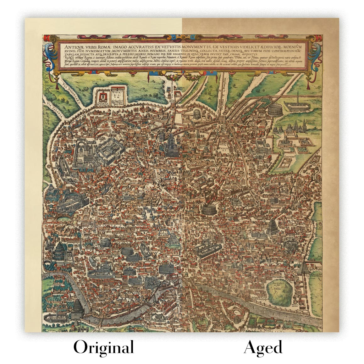
Well, now you can, by selecting Aged before you add a map to your basket.
All the product photos you see on this page show the map in its Original form. This is what the map looks like today.
If you select Aged, I will age your map by hand, using a special and unique process developed through years of studying old maps, talking to researchers to understand the chemistry of aging paper, and of course... lots of practice!
If you're unsure, stick to the Original colour of the map. If you want something a bit darker and older looking, go for Aged.
If you are not happy with your order for any reason, contact me for a no-quibble refund. Please see our returns and refund policy for more information.
I am very confident you will like your restored map or art print. I have been doing this since 1984. I'm a 5-star Etsy seller. I have sold tens of thousands of maps and art prints and have over 5,000 real 5-star reviews.
I use a unique process to restore maps and artwork that is massively time consuming and labour intensive. Hunting down the original maps and illustrations can take months. I use state of the art and eye-wateringly expensive technology to scan and restore them. As a result, I guarantee my maps and art prints are a cut above the rest - that's why I can offer a no-quibble refund.
Almost all of my maps and art prints look amazing at large sizes (200cm, 6.5ft+) and I can frame and deliver them to you as well, via special oversized courier. Contact me to discuss your specific needs.
Or try searching for something!


