


First Large Map of Catalonia by Aparici, 1769: Barcelona, Girona, Pyrenees, Ebro River, Bourbons

-
![]() Handmade locally in the EU
Handmade locally in the EU
-
FREE worldwide delivery in 2-3 days ⓘ
Free delivery in 2-3 days
Your map should be delivered in 2-3 working days with free delivery, worldwide.
We make maps by hand locally in 23 countries, including the EU
![]() . If you're buying a gift for someone in another country, we will make the map locally to them.
. If you're buying a gift for someone in another country, we will make the map locally to them.You will never pay import tax or customs duty.
Express delivery is available at checkout which can reduce the delivery time to 1-2 days.
Please note that personalised maps, and larger framed maps, can take longer to produce and deliver.
If you need your order to arrive by a certain date, contact me and we can discuss your options.
-
90 day money back guarantee
ⓘ
90 days to return and refund
Products can be returned within 90 days for a full refund, or exchange for another product.
For personalised or custom made items, we may offer you store credit or a non-expiring gift card, as we cannot resell personalised orders.
If you have any questions, get in touch. For more information, see our full returns & exchanges policy.

My maps are rare, museum-grade, restored old maps sourced from libraries, auction houses and private collections across the globe.
Framing & free personalisation available
1. Select your size
2. Frame & personalise your map
Make your map unique with framing, hand-drawn customisation, vintage ageing, pop art text, unique 3D styling and moreGift message & custom finish

If you want to add a gift message, or a finish (jigsaw, aluminium board, etc.) that is not available here, please request it in the "order note" when you check out.
Every order is custom made, so if you need the size adjusted slightly, or printed on an unusual material, just let us know. We've done thousands of custom orders over the years, so there's (almost) nothing we can't manage.
You can also contact us before you order, if you prefer!

- Handmade locally. No import duty or tax
- FREE Delivery. Arrives in 2-3 days
- Love it or your money back
- Questions? WhatsApp me any time
Own a piece of history
5,000+ 5 star reviews


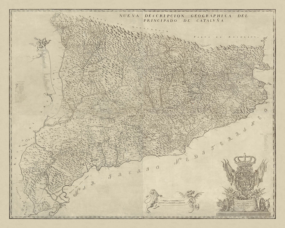
Step into the rich tapestry of 18th-century Catalonia with this exceptional map, titled "Nueva Descripcion Geographica Del Principado De Cataluña." Crafted by the distinguished Catalan geographer and Crown official Josep Aparici, this map is celebrated as the first large-format depiction of Catalonia created by a native son. First published in 1720 and refined in this 1769 edition, Aparici’s work stands as a testament to the region’s enduring spirit and its complex historical journey. The map’s intricate detail and baroque flourishes immediately draw the eye, inviting the viewer to explore a landscape shaped by mountains, rivers, and centuries of political upheaval.
Josep Aparici was not merely a mapmaker but a pivotal figure in the administrative transformation of Catalonia. As a trusted official under the Bourbon monarchy, Aparici traversed the region in the wake of the War of Spanish Succession, meticulously gathering data for the new corregiments—administrative divisions imposed after the Bourbon victory. His map is a vivid chronicle of this era, revealing both the physical grandeur of the Pyrenees and the Mediterranean coastline, as well as the newly imposed political order. Aparici’s allegiance to King Felipe V is unmistakably woven into the map’s very fabric, with an elaborate cartouche that celebrates Bourbon triumph and authority.
The artistry of Aparici’s map is matched only by its historical resonance. Decorative elements abound: an ornate dedicatory cartouche adorned with the Bourbon coat of arms and martial trophies, a scale of distance borne aloft by a lion and a dragon, and a cherub unfurling a scroll listing the region’s rectories. These flourishes are more than mere embellishments—they are visual narratives, reflecting the pride, conflict, and transformation that defined Catalonia in the early 18th century. The map’s design is a masterclass in baroque cartography, blending scientific precision with allegorical richness.
Geographically, the map captures the dramatic contrasts of Catalonia’s terrain. The imposing Pyrenees form a natural northern boundary, while the sunlit Mediterranean coast stretches invitingly to the east. Rivers such as the Ebro snake through the landscape, their courses clearly delineated alongside the region’s vital road networks. The map’s careful rendering of mountainous relief and waterways underscores both the beauty and the strategic importance of this storied land. Borders are meticulously drawn, with the northern reaches labeled as "Parte de Langeudoch," acknowledging the region’s proximity to France and its role as a crossroads of cultures and conflict.
Aparici’s map is also a window into the vibrant urban life of 18th-century Catalonia. Major cities like Barcelona, Tarragona, Girona, and Lleida are prominently featured, alongside a constellation of towns—Reus, Sabadell, Terrassa, and others—that would grow to define the region’s modern identity. These settlements, meticulously plotted, reflect the social and economic heartbeat of the principality. As both a work of art and a document of political change, Aparici’s "Nueva Descripcion Geographica Del Principado De Cataluña" remains a rare and compelling artifact—an invitation to explore the landscapes, histories, and ambitions of a proud and resilient region.
Cities and towns on this map
- Barcelona
- Tarragona
- Lleida (Lérida)
- Girona (Gerona)
- Reus
- Sabadell
- Terrassa
- Mataró
- Manresa
- Granollers
- Igualada
- Vic
- Figueres
- Olot
- Vilanova i la Geltrú
- Blanes
- Ripoll
- Cervera
- Tortosa
- La Seu d'Urgell
Notable Features & Landmarks
- The Pyrenees mountain range, forming the northern boundary of Catalonia
- The Mediterranean coastline along the eastern edge of the region
- Major rivers, including the Ebro (Ebre) and others clearly marked
- Administrative divisions (corregiments/corregimientos) imposed by the Bourbon monarchy
- The border with French Languedoc, labeled "Parte de Langeudoch"
- An elaborate dedicatory cartouche with the Bourbon coat of arms and war trophies, symbolizing Bourbon victory
- A scale of distance displayed on a banner held by a lion and a dragon
- A key and a list of rectories (ecclesiastical divisions) on a scroll unfurled by a cherub
- Road networks connecting major settlements and regions
- Mountainous terrain depicted with shaded relief and hachures
- Decorative flourishes typical of baroque cartography, such as ornate frames and allegorical figures
Historical and design context
- The first large-format map of Catalonia published by a Catalan, Josep Aparici, in 1720 (this edition 1769)
- Created after the War of Spanish Succession and during the Bourbon reorganization and repression of Catalonia
- Shows the corregiments, new administrative divisions imposed by the Bourbon monarchy after suppressing Catalan institutions and autonomy
- Marked a shift from Catalonia as a map consumer to a map producer, representing a hallmark of domestic Catalan cartography in the 18th century
- Dedicated to King Felipe V, signaling Aparici’s allegiance to the Bourbon monarchy
- Both the 1720 and 1769 editions are extremely rare, with only a handful of institutional copies known
- The map became the most consulted and reproduced map of Catalonia, influencing cartography into the 19th and 20th centuries
- Features a blend of scientific precision and allegorical richness, characteristic of baroque cartography
Please double check the images to make sure that a specific town or place is shown on this map. You can also get in touch and ask us to check the map for you.
This map looks great at every size, but I always recommend going for a larger size if you have space. That way you can easily make out all of the details.
This map looks amazing at sizes all the way up to 100in (250cm). If you are looking for a larger map, please get in touch.
Please note: the labels on this map are hard to read if you order a map that is 20in (50cm) or smaller. The map is still very attractive, but if you would like to read the map easily, please buy a larger size.
The model in the listing images is holding the 16x20in (40x50cm) version of this map.
The fifth listing image shows an example of my map personalisation service.
If you’re looking for something slightly different, check out my collection of the best old maps to see if something else catches your eye.
Please contact me to check if a certain location, landmark or feature is shown on this map.
This would make a wonderful birthday, Christmas, Father's Day, work leaving, anniversary or housewarming gift for someone from the areas covered by this map.
This map is available as a giclée print on acid free archival matte paper, or you can buy it framed. The frame is a nice, simple black frame that suits most aesthetics. Please get in touch if you'd like a different frame colour or material. My frames are glazed with super-clear museum-grade acrylic (perspex/acrylite), which is significantly less reflective than glass, safer, and will always arrive in perfect condition.
This map is also available as a float framed canvas, sometimes known as a shadow gap framed canvas or canvas floater. The map is printed on artist's cotton canvas and then stretched over a handmade box frame. We then "float" the canvas inside a wooden frame, which is available in a range of colours (black, dark brown, oak, antique gold and white). This is a wonderful way to present a map without glazing in front. See some examples of float framed canvas maps and explore the differences between my different finishes.
For something truly unique, this map is also available in "Unique 3D", our trademarked process that dramatically transforms the map so that it has a wonderful sense of depth. We combine the original map with detailed topography and elevation data, so that mountains and the terrain really "pop". For more info and examples of 3D maps, check my Unique 3D page.
For most orders, delivery time is about 3 working days. Personalised and customised products take longer, as I have to do the personalisation and send it to you for approval, which usually takes 1 or 2 days.
Please note that very large framed orders usually take longer to make and deliver.
If you need your order to arrive by a certain date, please contact me before you order so that we can find the best way of making sure you get your order in time.
I print and frame maps and artwork in 23 countries around the world. This means your order will be made locally, which cuts down on delivery time and ensures that it won't be damaged during delivery. You'll never pay customs or import duty, and we'll put less CO2 into the air.
All of my maps and art prints are well packaged and sent in a rugged tube if unframed, or surrounded by foam if framed.
I try to send out all orders within 1 or 2 days of receiving your order, though some products (like face masks, mugs and tote bags) can take longer to make.
If you select Express Delivery at checkout your order we will prioritise your order and send it out by 1-day courier (Fedex, DHL, UPS, Parcelforce).
Next Day delivery is also available in some countries (US, UK, Singapore, UAE) but please try to order early in the day so that we can get it sent out on time.
My standard frame is a gallery style black ash hardwood frame. It is simple and quite modern looking. My standard frame is around 20mm (0.8in) wide.
I use super-clear acrylic (perspex/acrylite) for the frame glass. It's lighter and safer than glass - and it looks better, as the reflectivity is lower.
Six standard frame colours are available for free (black, dark brown, dark grey, oak, white and antique gold). Custom framing and mounting/matting is available if you're looking for something else.
Most maps, art and illustrations are also available as a framed canvas. We use matte (not shiny) cotton canvas, stretch it over a sustainably sourced box wood frame, and then 'float' the piece within a wood frame. The end result is quite beautiful, and there's no glazing to get in the way.
All frames are provided "ready to hang", with either a string or brackets on the back. Very large frames will have heavy duty hanging plates and/or a mounting baton. If you have any questions, please get in touch.
See some examples of my framed maps and framed canvas maps.
Alternatively, I can also supply old maps and artwork on canvas, foam board, cotton rag and other materials.
If you want to frame your map or artwork yourself, please read my size guide first.
My maps are extremely high quality reproductions of original maps.
I source original, rare maps from libraries, auction houses and private collections around the world, restore them at my London workshop, and then use specialist giclée inks and printers to create beautiful maps that look even better than the original.
My maps are printed on acid-free archival matte (not glossy) paper that feels very high quality and almost like card. In technical terms the paper weight/thickness is 10mil/200gsm. It's perfect for framing.
I print with Epson ultrachrome giclée UV fade resistant pigment inks - some of the best inks you can find.
I can also make maps on canvas, cotton rag and other exotic materials.
Learn more about The Unique Maps Co.
Map personalisation
If you're looking for the perfect anniversary or housewarming gift, I can personalise your map to make it truly unique. For example, I can add a short message, or highlight an important location, or add your family's coat of arms.
The options are almost infinite. Please see my map personalisation page for some wonderful examples of what's possible.
To order a personalised map, select "personalise your map" before adding it to your basket.
Get in touch if you're looking for more complex customisations and personalisations.
Map ageing
I have been asked hundreds of times over the years by customers if they could buy a map that looks even older.
Well, now you can, by selecting Aged before you add a map to your basket.
All the product photos you see on this page show the map in its Original form. This is what the map looks like today.
If you select Aged, I will age your map by hand, using a special and unique process developed through years of studying old maps, talking to researchers to understand the chemistry of aging paper, and of course... lots of practice!
If you're unsure, stick to the Original colour of the map. If you want something a bit darker and older looking, go for Aged.
If you are not happy with your order for any reason, contact me for a no-quibble refund. Please see our returns and refund policy for more information.
I am very confident you will like your restored map or art print. I have been doing this since 1984. I'm a 5-star Etsy seller. I have sold tens of thousands of maps and art prints and have over 5,000 real 5-star reviews.
I use a unique process to restore maps and artwork that is massively time consuming and labour intensive. Hunting down the original maps and illustrations can take months. I use state of the art and eye-wateringly expensive technology to scan and restore them. As a result, I guarantee my maps and art prints are a cut above the rest - that's why I can offer a no-quibble refund.
Almost all of my maps and art prints look amazing at large sizes (200cm, 6.5ft+) and I can frame and deliver them to you as well, via special oversized courier. Contact me to discuss your specific needs.
Or try searching for something!


