


Old Map of Milan by Braun & Hogenberg, 1572: Cathedral, Fortifications, Streets, Fields

-
![]() Handmade locally in the EU
Handmade locally in the EU
-
FREE Christmas delivery: check the deadline
Free delivery in 3-4 days
Your map should be delivered in 3-4 working days with free delivery, worldwide.
Free delivery may arrive on time, but Express Delivery at checkout is safer. Unframed orders have a better chance of arriving in time with free delivery.
New for 2025: After you order, you can send a beautiful gift preview by email, if you're worried it won't arrive on time.
We make maps by hand locally in 23 countries, including the EU
![]() . If you're buying a gift for someone in another country, we will make the map locally to them.
. If you're buying a gift for someone in another country, we will make the map locally to them.You will never pay import tax or customs duty.
Check the Christmas delivery guide for order deadlines. Delivery times are starting to slow down, and will continue to slow down towards Christmas.
Express delivery is available at checkout which can reduce the delivery time to 1-2 days.
Please note that personalised maps, and larger framed maps, can take longer to produce and deliver.
If you need your order to arrive by a certain date, contact me and we can discuss your options.
-
90 day money back guarantee
ⓘ
90 days to return and refund
Products can be returned within 90 days for a full refund, or exchange for another product.
For personalised and custom made items, we may offer you store credit or a non-expiring gift card, as we cannot resell personalised orders.
If you have any questions, get in touch. For more information, see our full returns & exchanges policy.

My maps are rare, museum-grade, restored old maps sourced from libraries, auction houses and private collections across the globe.
Framing & free personalisation available
1. Select your size
2. Frame & personalise your map
There is limited framing & personalisation capacity available. Order by 10am tomorrow for Christmas delivery.


Gift message & custom finish

If you want to add a gift message, or a finish (jigsaw, aluminium board, etc.) that is not available here, please request it in the "order note" when you check out.
Every order is custom made, so if you need the size adjusted slightly, or printed on an unusual material, just let us know. We've done thousands of custom orders over the years, so there's (almost) nothing we can't manage.
You can also contact us before you order, if you prefer!

- Handmade locally. No import duty or tax
- FREE Delivery by Christmas
- Love it or your money back (90 days)
- Questions? WhatsApp me any time
Own a piece of history
5,000+ 5 star reviews


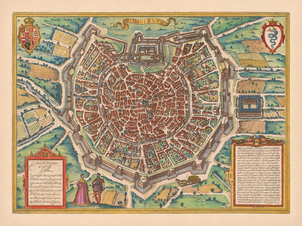
The map titled "Mediolanum," crafted by the renowned cartographers Georg Braun and Frans Hogenberg in 1572, offers a captivating bird's eye view of Milan. This exquisite piece is part of the influential "Civitates Orbis Terrarum," a collection that stands as a testament to the urban planning and architectural grandeur of the Renaissance. The map’s finely colored illustrations vividly capture the essence of Milan, showcasing its intricate layout and fortifications. As one of the earliest obtainable views of the city, it provides a unique glimpse into the historical landscape of this vibrant Italian metropolis.
Milan, a city steeped in history and culture, is depicted with remarkable detail. The central cathedral, a focal point of the map, symbolizes the city's architectural prowess and religious significance. Surrounding the city are meticulously illustrated agricultural fields, highlighting the region's rich agrarian heritage. The map also features heraldic shields and decorative cartouches, adding a layer of artistic elegance to this historical document.
The work of Braun and Hogenberg is notable not only for its artistic beauty but also for its historical accuracy. Their maps are celebrated for capturing the spirit of the cities they depict, and "Mediolanum" is no exception. The detailed rendering of Milan's streets and landmarks offers a window into the past, allowing viewers to explore the city's bustling neighborhoods and significant sites. This map is a valuable resource for historians and enthusiasts alike, providing insights into the urban development of one of Italy's most important cities.
The city’s intricate network of streets, such as Calle del Duomo and Calle dei Mercanti, are clearly labeled, inviting exploration and discovery. These thoroughfares, bustling with life and commerce, reflect Milan's status as a thriving center of trade and culture during the Renaissance. The depiction of city walls and fortifications further emphasizes Milan's strategic importance and its role as a defensive stronghold in the region.
Overall, this map of Milan is a remarkable blend of art and history, capturing the essence of a city that has long been a beacon of innovation and culture. The work of Braun and Hogenberg continues to inspire and educate, offering a timeless snapshot of Milan's past. Whether for academic study or personal appreciation, "Mediolanum" is a treasure that brings the rich tapestry of Renaissance Milan to life.
Streets and roads on this map
- Calle del Arcivescovado
- Calle della Scala
- Calle dei Fabbri
- Calle dei Mercanti
- Calle del Duomo
- Calle del Monte di Pietà
- Calle della Posta
- Calle di Sant'Ambrogio
- Calle di San Babila
- Calle di Santa Maria
- Calle di San Vittore
- Calle di Santo Stefano
- Calle della Zecca
- Calle del Broletto
- Calle del Carmine
- Calle del Gesù
- Calle del Lupo
- Calle del Popolo
- Calle del Teatro
- Calle del Verziere
- Calle delle Erbe
- Calle delle Ore
- Calle delle Palle
- Calle delle Scuole
- Calle delle Spade
- Calle di Brera
- Calle di Porta Nuova
- Calle di Porta Romana
- Calle di Porta Ticinese
- Calle di Porta Vercellina
Notable Features & Landmarks
- Illustrations:
- Decorative elements and figures in period attire.
- Landmarks:
- The central cathedral.
- City walls and fortifications.
- Other Notable Features:
- Agricultural fields surrounding the city.
- Heraldic shields and cartouches.
Historical and design context
- Creation Date: 1572
- Mapmakers/Publishers: Georg Braun and Frans Hogenberg
- Themes and Topics:
- City Bird's Eye View: Offers a detailed pictorial representation of Milan.
- Historical Context: One of the earliest obtainable views of Milan, providing insight into the city's layout during the Renaissance.
- Design/Style:
- Pictorial Map: Features a bird's eye view with detailed illustrations.
- Coloring: Finely colored, enhancing visual appeal and detail.
- Historical Significance:
- Influential Work: Part of a highly influential book of town views, reflecting urban design and architecture of the period.
Please double check the images to make sure that a specific town or place is shown on this map. You can also get in touch and ask us to check the map for you.
This map looks great at every size, but I always recommend going for a larger size if you have space. That way you can easily make out all of the details.
This map looks amazing at sizes all the way up to 90in (230cm). If you are looking for a larger map, please get in touch.
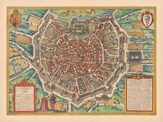
The model in the listing images is holding the 18x24in (45x60cm) version of this map.
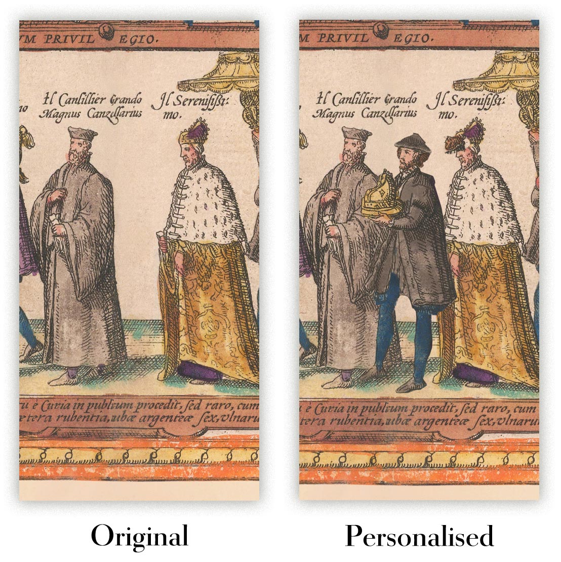
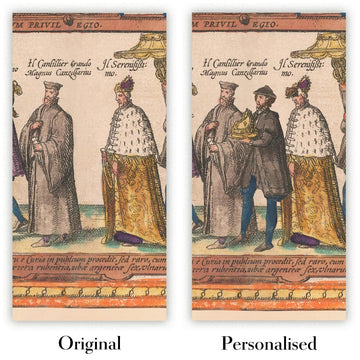
The fifth listing image shows an example of my map personalisation service.
If you’re looking for something slightly different, check out my collection of the best old maps to see if something else catches your eye.
Please contact me to check if a certain location, landmark or feature is shown on this map.
This would make a wonderful birthday, Christmas, Father's Day, work leaving, anniversary or housewarming gift for someone from the areas covered by this map.
This map is available as a giclée print on acid free archival matte paper, or you can buy it framed. The frame is a nice, simple black frame that suits most aesthetics. Please get in touch if you'd like a different frame colour or material. My frames are glazed with super-clear museum-grade acrylic (perspex/acrylite), which is significantly less reflective than glass, safer, and will always arrive in perfect condition.
This map is also available as a float framed canvas, sometimes known as a shadow gap framed canvas or canvas floater. The map is printed on artist's cotton canvas and then stretched over a handmade box frame. We then "float" the canvas inside a wooden frame, which is available in a range of colours (black, dark brown, oak, antique gold and white). This is a wonderful way to present a map without glazing in front. See some examples of float framed canvas maps and explore the differences between my different finishes.
For something truly unique, this map is also available in "Unique 3D", our trademarked process that dramatically transforms the map so that it has a wonderful sense of depth. We combine the original map with detailed topography and elevation data, so that mountains and the terrain really "pop". For more info and examples of 3D maps, check my Unique 3D page.
For most orders, delivery time is about 3 working days. Personalised and customised products take longer, as I have to do the personalisation and send it to you for approval, which usually takes 1 or 2 days.
Please note that very large framed orders usually take longer to make and deliver.
If you need your order to arrive by a certain date, please contact me before you order so that we can find the best way of making sure you get your order in time.
I print and frame maps and artwork in 23 countries around the world. This means your order will be made locally, which cuts down on delivery time and ensures that it won't be damaged during delivery. You'll never pay customs or import duty, and we'll put less CO2 into the air.
All of my maps and art prints are well packaged and sent in a rugged tube if unframed, or surrounded by foam if framed.
I try to send out all orders within 1 or 2 days of receiving your order, though some products (like face masks, mugs and tote bags) can take longer to make.
If you select Express Delivery at checkout your order we will prioritise your order and send it out by 1-day courier (Fedex, DHL, UPS, Parcelforce).
Next Day delivery is also available in some countries (US, UK, Singapore, UAE) but please try to order early in the day so that we can get it sent out on time.
My standard frame is a gallery style black ash hardwood frame. It is simple and quite modern looking. My standard frame is around 20mm (0.8in) wide.
I use super-clear acrylic (perspex/acrylite) for the frame glass. It's lighter and safer than glass - and it looks better, as the reflectivity is lower.
Six standard frame colours are available for free (black, dark brown, dark grey, oak, white and antique gold). Custom framing and mounting/matting is available if you're looking for something else.
Most maps, art and illustrations are also available as a framed canvas. We use matte (not shiny) cotton canvas, stretch it over a sustainably sourced box wood frame, and then 'float' the piece within a wood frame. The end result is quite beautiful, and there's no glazing to get in the way.
All frames are provided "ready to hang", with either a string or brackets on the back. Very large frames will have heavy duty hanging plates and/or a mounting baton. If you have any questions, please get in touch.
See some examples of my framed maps and framed canvas maps.
Alternatively, I can also supply old maps and artwork on canvas, foam board, cotton rag and other materials.
If you want to frame your map or artwork yourself, please read my size guide first.
My maps are extremely high quality reproductions of original maps.
I source original, rare maps from libraries, auction houses and private collections around the world, restore them at my London workshop, and then use specialist giclée inks and printers to create beautiful maps that look even better than the original.
My maps are printed on acid-free archival matte (not glossy) paper that feels very high quality and almost like card. In technical terms the paper weight/thickness is 10mil/200gsm. It's perfect for framing.
I print with Epson ultrachrome giclée UV fade resistant pigment inks - some of the best inks you can find.
I can also make maps on canvas, cotton rag and other exotic materials.
Learn more about The Unique Maps Co.
Map personalisation
If you're looking for the perfect anniversary or housewarming gift, I can personalise your map to make it truly unique. For example, I can add a short message, or highlight an important location, or add your family's coat of arms.
The options are almost infinite. Please see my map personalisation page for some wonderful examples of what's possible.
To order a personalised map, select "personalise your map" before adding it to your basket.
Get in touch if you're looking for more complex customisations and personalisations.
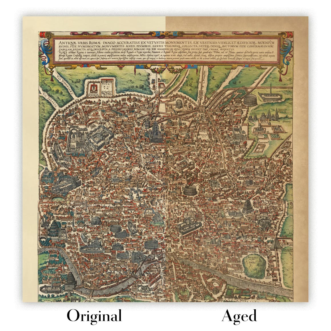
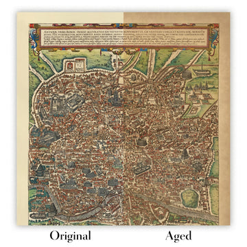
Map ageing
I have been asked hundreds of times over the years by customers if they could buy a map that looks even older.
Well, now you can, by selecting Aged before you add a map to your basket.
All the product photos you see on this page show the map in its Original form. This is what the map looks like today.
If you select Aged, I will age your map by hand, using a special and unique process developed through years of studying old maps, talking to researchers to understand the chemistry of aging paper, and of course... lots of practice!
If you're unsure, stick to the Original colour of the map. If you want something a bit darker and older looking, go for Aged.
If you are not happy with your order for any reason, contact me and I'll get it fixed ASAP, free of charge. Please see my returns and refund policy for more information.
I am very confident you will like your restored map or art print. I have been doing this since 1984. I'm a 5-star Etsy seller. I have sold tens of thousands of maps and art prints and have over 5,000 real 5-star reviews. My work has been featured in interior design magazines, on the BBC, and on the walls of dozens of 5-star hotels.
I use a unique process to restore maps and artwork that is massively time consuming and labour intensive. Hunting down the original maps and illustrations can take months. I use state of the art and eye-wateringly expensive technology to scan and restore them. As a result, I guarantee my maps and art prints are a cut above the rest. I stand by my products and will always make sure you're 100% happy with what you receive.
Almost all of my maps and art prints look amazing at large sizes (200cm, 6.5ft+) and I can frame and deliver them to you as well, via special oversized courier. Contact me to discuss your specific needs.
Or try searching for something!


