


Old Infographic Map of North American Demographics & Communications, 1967: Cold War Road & Rail Chart

-
![]() Handmade locally in the EU
Handmade locally in the EU
-
FREE worldwide delivery in 2-3 days ⓘ
Free delivery in 2-3 days
Your map should be delivered in 2-3 working days with free delivery, worldwide.
We make maps by hand locally in 23 countries, including the EU
![]() . If you're buying a gift for someone in another country, we will make the map locally to them.
. If you're buying a gift for someone in another country, we will make the map locally to them.You will never pay import tax or customs duty.
Express delivery is available at checkout which can reduce the delivery time to 1-2 days.
Please note that personalised maps, and larger framed maps, can take longer to produce and deliver.
If you need your order to arrive by a certain date, contact me and we can discuss your options.
-
90 day money back guarantee
ⓘ
90 days to return and refund
Products can be returned within 90 days for a full refund, or exchange for another product.
For personalised or custom made items, we may offer you store credit or a non-expiring gift card, as we cannot resell personalised orders.
If you have any questions, get in touch. For more information, see our full returns & exchanges policy.

My maps are rare, museum-grade, restored old maps sourced from libraries, auction houses and private collections across the globe.
Framing & free personalisation available
1. Select your size
2. Frame & personalise your map
Make your map unique with framing, hand-drawn customisation, vintage ageing, pop art text, unique 3D styling and moreGift message & custom finish

If you want to add a gift message, or a finish (jigsaw, aluminium board, etc.) that is not available here, please request it in the "order note" when you check out.
Every order is custom made, so if you need the size adjusted slightly, or printed on an unusual material, just let us know. We've done thousands of custom orders over the years, so there's (almost) nothing we can't manage.
You can also contact us before you order, if you prefer!

- Handmade locally. No import duty or tax
- FREE Delivery. Arrives in 2-3 days
- Love it or your money back
- Questions? WhatsApp me any time
Own a piece of history
5,000+ 5 star reviews


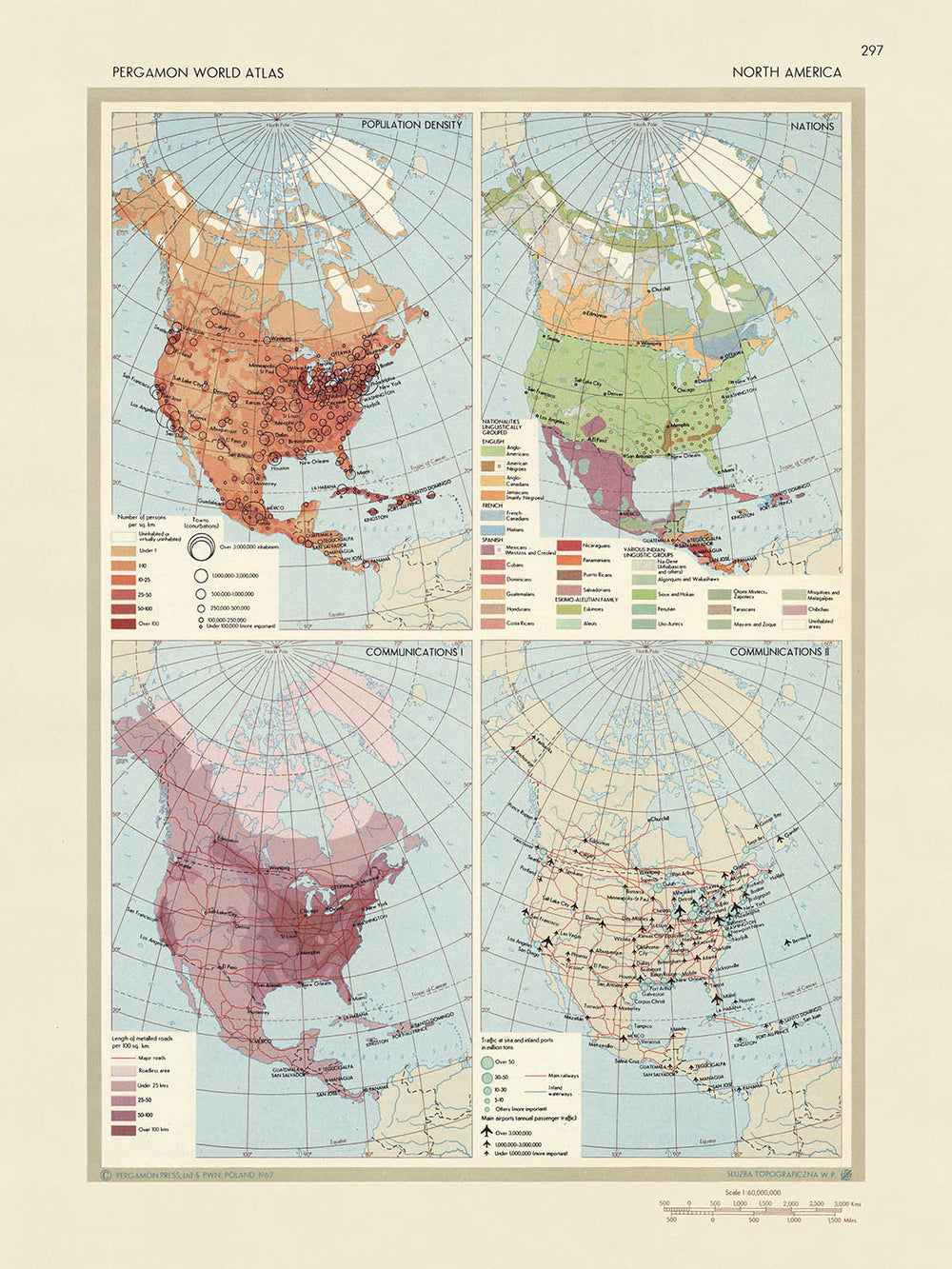
This 1967 North America Demographics & Communications map, originally published by the Polish Army Topography Service, is an intriguing relic of the Cold War era. It offers a unique perspective on the geopolitical climate of the time, presenting a wealth of demographic and communication data in a visually captivating manner. The map's primary focus is on North America, with a particular emphasis on the United States and Canada, making it an invaluable resource for understanding the region's development during the mid-20th century.
The map's most striking feature is its four small inset maps, each providing additional layers of information. These maps depict population density, nations (peoples), and communications, enhancing the overall understanding of the main map's data. Thematic in style, the map employs a range of symbols and colors to represent various types of data, accompanied by a detailed legend for easy interpretation.
Beyond its aesthetic appeal, this map holds significant historical value. Published at the height of the Cold War, it reflects the geopolitical tensions of the era. The Polish Army Topography Service, responsible for creating the map, was tasked with providing accurate and reliable cartographic information for military purposes. This context adds a layer of intrigue to the map, as it was likely used in strategic planning and decision-making during a time of heightened global conflict.
The map's data provides insights into the demographics and communication networks of North America in the 1960s. It showcases major cities, transportation routes, rivers, lakes, mountain ranges, climate zones, vegetation zones, land use zones, political divisions, economic zones, and cultural zones. This comprehensive range of information makes the map a valuable tool for historians, geographers, and anyone interested in understanding the evolution of North America's infrastructure and societal development.
Furthermore, the map serves as a reminder of the importance of accurate and reliable information in shaping our understanding of the world. In an age dominated by digital mapping and instant data access, it is easy to take for granted the precision and effort that went into creating such maps in the past. This 1967 North America Demographics & Communications map stands as a testament to the skill and dedication of cartographers, preserving a valuable snapshot of a bygone era.
- The map was published in 1967, during the Cold War, and the cartographic choices reflect this.
- The map was created by the Polish Army Topography Service, which was responsible for creating maps for the Polish military.
- The map focuses on demographics and communications in North America, with a particular emphasis on the United States and Canada.
- The map includes four small inset maps that provide additional information on population density, nations (peoples), and communications.
- The map uses a variety of symbols and colors to represent different types of data, including population density, major cities, and transportation routes.
- The map also includes a legend that explains the meaning of the symbols and colors used.
- The map is a valuable resource for understanding the demographics and communications of North America in the 1960s.
- The map provides a unique perspective on the Cold War and the geopolitical situation of the time.
- The map is a beautiful example of cartography and is a valuable addition to any collection of old maps.
-
The map is a reminder of the importance of accurate and reliable information in understanding the world around us.
-
The map shows the major cities of North America, including New York, Chicago, and Los Angeles.
- The map shows the major transportation routes of North America, including highways, railroads, and shipping lanes.
- The map shows the major rivers and lakes of North America, including the Mississippi River and the Great Lakes.
- The map shows the major mountain ranges of North America, including the Rocky Mountains and the Appalachian Mountains.
- The map shows the major climate zones of North America, including the tropical zone, the temperate zone, and the polar zone.
- The map shows the major vegetation zones of North America, including the forests, the grasslands, and the deserts.
- The map shows the major land use zones of North America, including the agricultural zones, the industrial zones, and the urban zones.
- The map shows the major political divisions of North America, including the countries, the states, and the provinces.
- The map shows the major economic zones of North America, including the manufacturing zones, the service zones, and the agricultural zones.
- The map shows the major cultural zones of North America, including the English-speaking zone, the Spanish-speaking zone, and the French-speaking zone.
Please double check the images to make sure that a specific town or place is shown on this map. You can also get in touch and ask us to check the map for you.
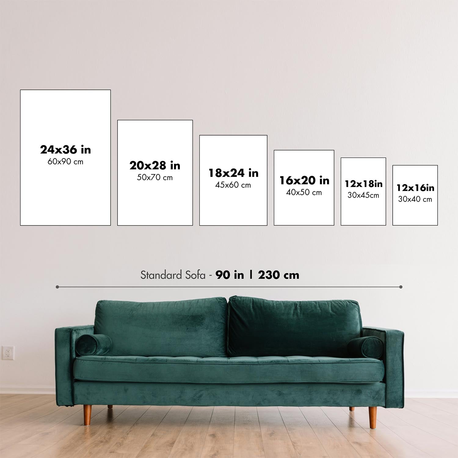
This map looks great at every size, but I always recommend going for a larger size if you have space. That way you can easily make out all of the details.
This map looks amazing at sizes all the way up to 50in (125cm). If you are looking for a larger map, please get in touch.
The model in the listing images is holding the 18x24in (45x60cm) version of this map.
The fifth listing image shows an example of my map personalisation service.
If you’re looking for something slightly different, check out my collection of the best old maps to see if something else catches your eye.
Please contact me to check if a certain location, landmark or feature is shown on this map.
This would make a wonderful birthday, Christmas, Father's Day, work leaving, anniversary or housewarming gift for someone from the areas covered by this map.
This map is available as a giclée print on acid free archival matte paper, or you can buy it framed. The frame is a nice, simple black frame that suits most aesthetics. Please get in touch if you'd like a different frame colour or material. My frames are glazed with super-clear museum-grade acrylic (perspex/acrylite), which is significantly less reflective than glass, safer, and will always arrive in perfect condition.
This map is also available as a float framed canvas, sometimes known as a shadow gap framed canvas or canvas floater. The map is printed on artist's cotton canvas and then stretched over a handmade box frame. We then "float" the canvas inside a wooden frame, which is available in a range of colours (black, dark brown, oak, antique gold and white). This is a wonderful way to present a map without glazing in front. See some examples of float framed canvas maps and explore the differences between my different finishes.
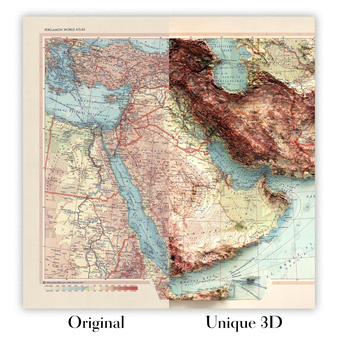
For something truly unique, this map is also available in "Unique 3D", our trademarked process that dramatically transforms the map so that it has a wonderful sense of depth. We combine the original map with detailed topography and elevation data, so that mountains and the terrain really "pop". For more info and examples of 3D maps, check my Unique 3D page.
For most orders, delivery time is about 3 working days. Personalised and customised products take longer, as I have to do the personalisation and send it to you for approval, which usually takes 1 or 2 days.
Please note that very large framed orders usually take longer to make and deliver.
If you need your order to arrive by a certain date, please contact me before you order so that we can find the best way of making sure you get your order in time.
I print and frame maps and artwork in 23 countries around the world. This means your order will be made locally, which cuts down on delivery time and ensures that it won't be damaged during delivery. You'll never pay customs or import duty, and we'll put less CO2 into the air.
All of my maps and art prints are well packaged and sent in a rugged tube if unframed, or surrounded by foam if framed.
I try to send out all orders within 1 or 2 days of receiving your order, though some products (like face masks, mugs and tote bags) can take longer to make.
If you select Express Delivery at checkout your order we will prioritise your order and send it out by 1-day courier (Fedex, DHL, UPS, Parcelforce).
Next Day delivery is also available in some countries (US, UK, Singapore, UAE) but please try to order early in the day so that we can get it sent out on time.
My standard frame is a gallery style black ash hardwood frame. It is simple and quite modern looking. My standard frame is around 20mm (0.8in) wide.
I use super-clear acrylic (perspex/acrylite) for the frame glass. It's lighter and safer than glass - and it looks better, as the reflectivity is lower.
Six standard frame colours are available for free (black, dark brown, dark grey, oak, white and antique gold). Custom framing and mounting/matting is available if you're looking for something else.
Most maps, art and illustrations are also available as a framed canvas. We use matte (not shiny) cotton canvas, stretch it over a sustainably sourced box wood frame, and then 'float' the piece within a wood frame. The end result is quite beautiful, and there's no glazing to get in the way.
All frames are provided "ready to hang", with either a string or brackets on the back. Very large frames will have heavy duty hanging plates and/or a mounting baton. If you have any questions, please get in touch.
See some examples of my framed maps and framed canvas maps.
Alternatively, I can also supply old maps and artwork on canvas, foam board, cotton rag and other materials.
If you want to frame your map or artwork yourself, please read my size guide first.
My maps are extremely high quality reproductions of original maps.
I source original, rare maps from libraries, auction houses and private collections around the world, restore them at my London workshop, and then use specialist giclée inks and printers to create beautiful maps that look even better than the original.
My maps are printed on acid-free archival matte (not glossy) paper that feels very high quality and almost like card. In technical terms the paper weight/thickness is 10mil/200gsm. It's perfect for framing.
I print with Epson ultrachrome giclée UV fade resistant pigment inks - some of the best inks you can find.
I can also make maps on canvas, cotton rag and other exotic materials.
Learn more about The Unique Maps Co.
Map personalisation
If you're looking for the perfect anniversary or housewarming gift, I can personalise your map to make it truly unique. For example, I can add a short message, or highlight an important location, or add your family's coat of arms.
The options are almost infinite. Please see my map personalisation page for some wonderful examples of what's possible.
To order a personalised map, select "personalise your map" before adding it to your basket.
Get in touch if you're looking for more complex customisations and personalisations.
Map ageing
I have been asked hundreds of times over the years by customers if they could buy a map that looks even older.
Well, now you can, by selecting Aged before you add a map to your basket.
All the product photos you see on this page show the map in its Original form. This is what the map looks like today.
If you select Aged, I will age your map by hand, using a special and unique process developed through years of studying old maps, talking to researchers to understand the chemistry of aging paper, and of course... lots of practice!
If you're unsure, stick to the Original colour of the map. If you want something a bit darker and older looking, go for Aged.
If you are not happy with your order for any reason, contact me for a no-quibble refund. Please see our returns and refund policy for more information.
I am very confident you will like your restored map or art print. I have been doing this since 1984. I'm a 5-star Etsy seller. I have sold tens of thousands of maps and art prints and have over 5,000 real 5-star reviews.
I use a unique process to restore maps and artwork that is massively time consuming and labour intensive. Hunting down the original maps and illustrations can take months. I use state of the art and eye-wateringly expensive technology to scan and restore them. As a result, I guarantee my maps and art prints are a cut above the rest - that's why I can offer a no-quibble refund.
Almost all of my maps and art prints look amazing at large sizes (200cm, 6.5ft+) and I can frame and deliver them to you as well, via special oversized courier. Contact me to discuss your specific needs.
Or try searching for something!


