


Alte Karte von Treasure Island & der Golden Gate International Exposition, 1939: Turm der Sonne, Gericht der sieben Meere, Kalifornisches Gebäude, Bay Bridge, San Francisco
Das Sammlerangebot
Wählen Sie zwei berechtigte Werke und erhalten Sie auf beide 20 % Rabatt. Wählen Sie drei, und das günstigste ist kostenlos – eine maximale Ersparnis von 33 %.
Kombinieren Sie berechtigte Standardkarten und Kunstdrucke nach Belieben. Kein Code erforderlich; das Angebot wird an der Kasse automatisch angewendet.
Standardmäßige Konfigurationen nach Maßanfertigung sind inbegriffen. Maßgeschneiderte Größen, personalisierte Entwürfe und Auftragsarbeiten sind ausgeschlossen.
Benötigen Sie die Lieferung an unterschiedliche Adressen? Kontaktieren Sie uns vor der Bestellung.Das Sammlerangebot
Wählen Sie zwei berechtigte Werke und erhalten Sie auf beide 20 % Rabatt. Wählen Sie drei, und das günstigste ist kostenlos – eine maximale Ersparnis von 33 %.
Kombinieren Sie berechtigte Standardkarten und Kunstdrucke nach Belieben. Kein Code erforderlich; das Angebot wird an der Kasse automatisch angewendet.
Standardmäßige Konfigurationen nach Maßanfertigung sind inbegriffen. Maßgeschneiderte Größen, personalisierte Entwürfe und Auftragsarbeiten sind ausgeschlossen.
Benötigen Sie die Lieferung an unterschiedliche Adressen? Kontaktieren Sie uns vor der Bestellung. In London restauriert • Hergestellt in der EU

Aus der Originalkarte von 1939 restauriert und in Museumsqualität gedruckt. Die Geschichte hinter dieser Karte lesen
Choose your size
Choose your finish


(Mehr Infos)
Geschenkmitteilung & individuelle Ausführung

Wenn Sie eine Geschenkmitteilung oder eine Ausführung (Puzzle, Aluminiumplatte usw.) hinzufügen möchten, die hier nicht verfügbar ist, geben Sie dies bitte in der "Bestellnotiz" beim Checkout an.
Jede Bestellung wird individuell angefertigt. Wenn Sie die Größe leicht anpassen oder auf einem ungewöhnlichen Material drucken lassen möchten, lassen Sie es uns einfach wissen. Wir haben im Laufe der Jahre Tausende von individuellen Bestellungen bearbeitet, daher gibt es (fast) nichts, was wir nicht bewältigen können.
Sie können uns auch kontaktieren, bevor Sie bestellen, wenn Sie möchten!

- Lokal gefertigt. Sicher geliefert
- Keine Zölle oder versteckten Gebühren
- Hilfe nötig? Rufen Sie uns an oder WhatsApp schreiben
Own a piece of history
8,000+ five-star reviews


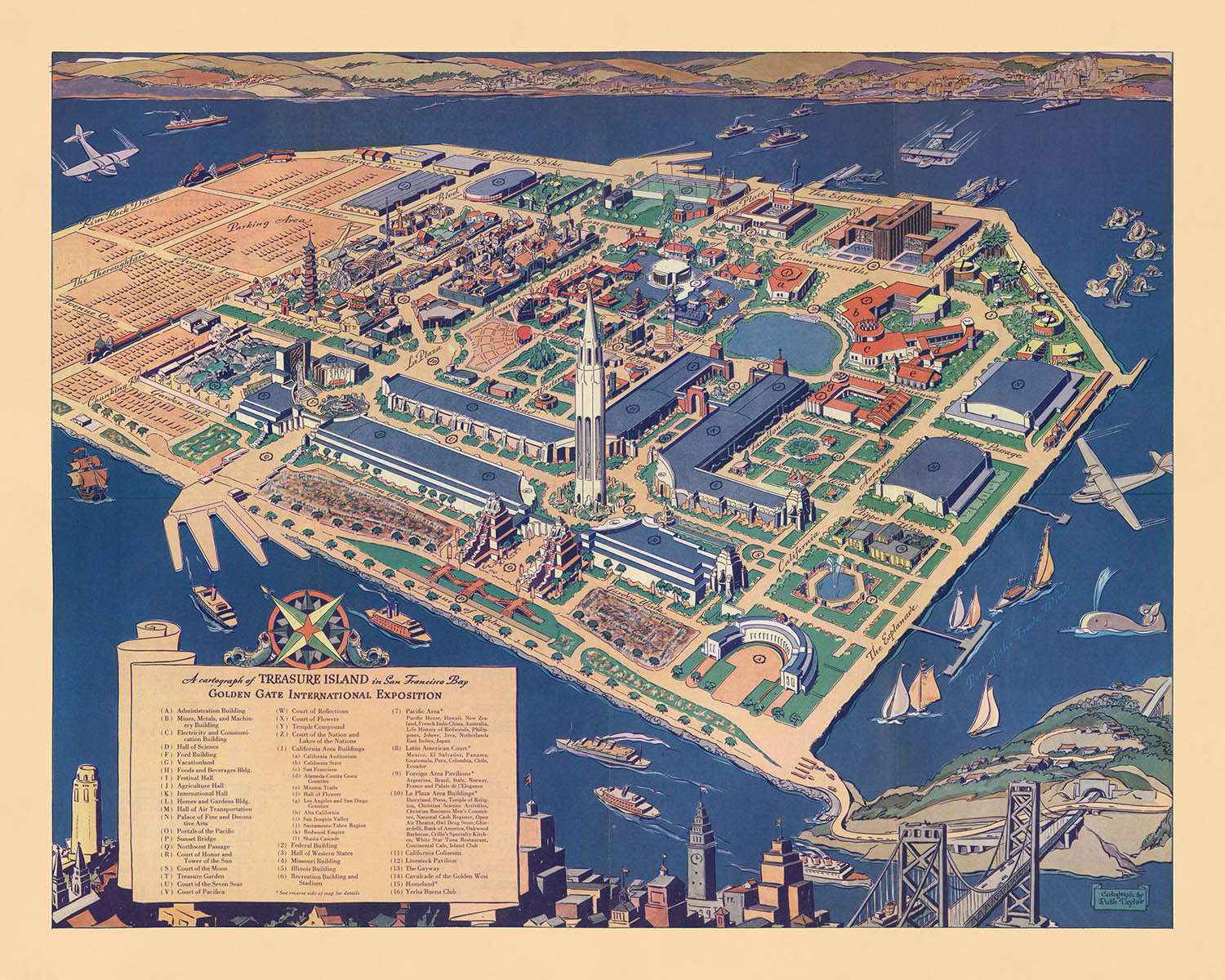
Betreten Sie die lebendige Welt der späten 1930er Jahre mit dieser exquisiten bildlichen Karte, „Eine Karte von Treasure Island in der Bucht...
WeiterlesenBetreten Sie die lebendige Welt der späten 1930er Jahre mit dieser exquisiten bildlichen Karte, „Eine Karte von Treasure Island in der Bucht von San Francisco“, meisterhaft erstellt von Ruth Taylor White im Jahr 1939. Beauftragt für die Golden Gate International Exposition, ist diese Karte ein seltenes und fesselndes Artefakt, das den Geist eines entscheidenden Moments in der Geschichte San Franciscos einfängt. Mit ihrer weitreichenden Vogelperspektive erweckt die Karte die neu errichtete Treasure Island zum Leben, ein Wunderwerk der Ingenieurskunst und des Ehrgeizes, das speziell gebaut wurde, um die Weltausstellung auszurichten und die Innovation der Bay Area auf einer globalen Bühne zu präsentieren.
Ruth Taylor Whites Kunstfertigkeit zeigt sich in jedem Detail, indem sie verspielte Illustrationen mit präzisen kartografischen Informationen verbindet. Die Gewässer rund um Treasure Island wimmeln von Seeungeheuern, Walen, Booten und Flugzeugen, wobei jedes Element spielerisch gestaltet ist, um die Aufregung und den Optimismus der Ausstellung zu wecken. Die lebhaften Vignetten und die lebendige Farbpalette der Karte laden die Betrachter ein, nicht nur den physischen Raum der Ausstellungsgelände zu erkunden, sondern auch die einfallsreichen Möglichkeiten der Epoche. Die Einbeziehung einer Legende und klar gekennzeichneter Ausstellungsgebäude erhöht ihren Wert weiter, wodurch sie sowohl ein Navigationswerkzeug als auch ein Kunstwerk ist.
Historisch gesehen steht diese Karte als Zeugnis für die kulturellen und architektonischen Errungenschaften der Golden Gate International Exposition. Die Ausstellungsgelände, sorgfältig dargestellt, heben bedeutende Wahrzeichen wie den Tower of the Sun, den Court of the Seven Seas und das California Building hervor. Diese Strukturen, von denen viele temporär, aber groß im Maßstab waren, repräsentierten die Bestrebungen einer Stadt, die aus der Großen Depression hervorgeht und auf eine hellere, vernetzte Zukunft blickt. Die Karte zeigt auch die ikonische Bay Bridge, die San Francisco mit Treasure Island verbindet und die Rolle der Stadt als Tor zum Pazifik symbolisiert.
Über ihre unmittelbare Funktion als Führer für die Messebesucher hinaus bietet die Karte einen faszinierenden Einblick in die urbane Landschaft von San Francisco zu Beginn des Zweiten Weltkriegs. Die Uferpromenade der Stadt, geschäftige Fährterminals und die sorgfältig geplanten Ausstellungspavillons spiegeln das dynamische Zusammenspiel zwischen Tradition und Modernität wider. Die Einbeziehung von Erholungsgebieten, Gärten und thematischen Illustrationen unterstreicht den internationalen Umfang der Messe und ihre Feier des Fortschritts, der Kultur und der Gemeinschaft.
Sammler und Historiker werden die einzigartige Mischung aus künstlerischem Flair und dokumentarischer Präzision der Karte zu schätzen wissen. Als sowohl historisches Artefakt als auch visuelle Erzählung fasst sie den Optimismus, die Kreativität und die kosmopolitische Energie San Franciscos im Jahr 1939 zusammen. Ob als Mittelpunkt ausgestellt oder für ihre reichhaltigen Details studiert, bietet diese Karte eine immersive Reise in ein prägendes Kapitel der Geschichte der Stadt und ist eine außergewöhnliche Ergänzung jeder Sammlung feiner historischer Kartografie.
Orte auf dieser Karte
- Treasure Island
- San Francisco (Stadt)
- Gelände der Golden Gate International Exposition
- Bay Bridge (San Francisco-Oakland Bay Bridge)
- Verwaltungsgebäude (auf Treasure Island)
- Halle für Verkehr (auf Treasure Island)
- Gericht der sieben Meere (auf Treasure Island)
- Turm der Sonne (auf Treasure Island)
- Kalifornisches Gebäude (auf Treasure Island)
- Bundesgebäude (auf Treasure Island)
- Palast der Schönen und Dekorativen Künste (auf Treasure Island)
- Luftfahrtgebäude (auf Treasure Island)
- Haupteingang (zu den Ausstellungsgeländen)
- Fährterminal (auf Treasure Island)
- Yachthafen (neben Treasure Island)
- Gärten und Erholungsgebiete (auf Treasure Island)
- San Francisco Uferpromenade (Embarcadero-Bereich)
- Fährverbindungen zwischen San Francisco und Treasure Island
- Flugplatz oder Luftfahrtbereich (auf Treasure Island)
- Ausstellungspavillons und Ausstellungsräume (verschiedene, auf Treasure Island)
Bemerkenswerte Merkmale & Wahrzeichen
- Die Ausstellungsgelände mit klar gekennzeichneten Gebäuden und Pavillons
- Eine Legende, die wichtige Ausstellungsgebäude und Merkmale identifiziert
- Die Skyline von San Francisco im Vordergrund, einschließlich erkennbarer Wahrzeichen
- Verspielt illustrierte Seeungeheuer in den Gewässern rund um Treasure Island
- Wale und andere Meereslebewesen, die in der Bucht dargestellt sind
- Boote und Schiffe, die die Gewässer rund um die Insel befahren
- Flugzeuge, die über die Ausstellung fliegen und die Modernität der Veranstaltung betonen
- Brücken, die San Francisco mit der Insel verbinden (einschließlich der Bay Bridge)
- Dekorative Kompassrose oder Orientierungspunkt
- Künstlerischer Rand mit thematischen Motiven, die mit der Ausstellung verbunden sind
- Wegweiser und Straßen, die auf Treasure Island klar gekennzeichnet sind
- Flaggen und Banner, die die festliche Natur der Veranstaltung anzeigen
- Notizen oder Beschriftungen für bedeutende Ausstellungsgebäude
- Illustrationen von Menschenmengen oder Besuchern, die die Messe besuchen
- Thematische Illustrationen, die den internationalen Rahmen der Ausstellung widerspiegeln
- Bunte, stilisierte Darstellungen von Wasser und Land
- Erklärende Texte oder Hinweise, die Kontext für bestimmte Merkmale bieten
- Prominente Darstellung des Jahres "1939" und des Titels der Ausstellung
Historischer und gestalterischer Kontext
- Name der Karte: Eine Kartographie von Treasure Island in der San Francisco Bay
- Kartograph: Ruth Taylor White, eine bekannte amerikanische bildliche Kartographin, die für ihre bunten, verspielten und detaillierten Karten bekannt ist
- Erstellungsdatum: 1939
- Verlag: Crocker Company, San Francisco
- Erstellt für die Golden Gate International Exposition, eine Weltausstellung, die 1939 auf Treasure Island in der San Francisco Bay stattfand
- Vogelperspektive auf die illustrierte Karte, reich verziert mit lebhaften und verspielten Elementen
- Teil eines Reiseführers mit einem Art-Deco-Cover, das die Ästhetik der späten 1930er Jahre widerspiegelt
- Enthält eine Legende, die verschiedene Ausstellungsgebäude und Merkmale identifiziert, was ihren Nutzen für Besucher und Historiker erhöht
- Fängt die Pracht und den Geist der Golden Gate International Exposition 1939 ein, einem bedeutenden kulturellen und architektonischen Ereignis in der Geschichte San Franciscos
- Hebt die Ausstellungsgelände, architektonischen Merkmale, Freizeitaktivitäten und die festliche Atmosphäre der Weltausstellung hervor
- Diente sowohl als Navigationshilfe für die Teilnehmer der Ausstellung als auch als historisches Artefakt, das das Ereignis dokumentiert
- Treasure Island wurde speziell für die Ausstellung errichtet und symbolisiert Innovation und Fortschritt in der Bay Area
- Spiegelt den Optimismus und die Begeisterung des späten Amerikas der 1930er Jahre wider, insbesondere im Kontext internationaler Ausstellungen
- Ruth Taylor White war bekannt für ihre Fähigkeit, das Wesen eines Ortes sowohl durch kartografische Details als auch durch künstlerische Verzierungen einzufangen
- Die Karte bleibt eine wertvolle Ressource für Historiker, Sammler und Interessierte an der Geschichte San Franciscos und der Weltausstellungen
Bitte überprüfen Sie die Bilder sorgfältig, um sicherzustellen, dass eine bestimmte Stadt oder ein bestimmter Ort auf dieser Karte angezeigt wird. Sie können uns auch kontaktieren und fragen, ob wir die Karte für Sie überprüfen können.
Diese Karte sieht in jeder Größe großartig aus, aber ich empfehle immer, eine größere Größe zu wählen, wenn Sie Platz haben. So können Sie alle Details leicht erkennen.
Diese Karte sieht in Größen bis zu 70 Zoll (180 cm) erstaunlich aus. Wenn Sie nach einer größeren Karte suchen, bitte kontaktieren Sie uns.
Das Modell auf den Angebotsbildern hält die 16x20 Zoll (40x50 cm) Version dieser Karte.
Das fünfte Angebotsbild zeigt ein Beispiel für meinen Personalisierungsservice für Karten.
Wenn Sie nach etwas leicht anderem suchen, schauen Sie sich meine Sammlung der besten alten Karten an, um zu sehen, ob Ihnen etwas anderes ins Auge fällt.
Bitte kontaktieren Sie mich, um zu überprüfen, ob ein bestimmter Standort, ein Wahrzeichen oder ein Merkmal auf dieser Karte angezeigt wird.
Dies wäre ein wunderbares Geschenk zum Geburtstag, zu Weihnachten, zum Vatertag, zum Abschied von der Arbeit, zum Jubiläum oder zur Einweihung für jemanden aus den Gebieten, die von dieser Karte abgedeckt werden.
Diese Karte ist als Giclée-Druck auf säurefreiem, archivierbarem mattem Papier erhältlich, oder Sie können sie gerahmt kaufen. Der Rahmen ist ein schöner, einfacher schwarzer Rahmen, der den meisten Ästhetiken entspricht. Bitte kontaktieren Sie mich, wenn Sie eine andere Rahmenfarbe oder -material wünschen. Meine Rahmen sind mit superklarem, museumsgrauem Acryl (Plexiglas/Acrylt) verglast, das deutlich weniger reflektierend als Glas ist, sicherer und immer in perfektem Zustand ankommt.
This map is also available as a float framed canvas, sometimes known as a shadow gap framed canvas or canvas floater. The map is printed on artist's cotton canvas and then stretched over a handmade box frame. We then "float" the canvas inside a wooden frame, which is available in a range of colours (black, dark brown, oak, antique gold and white). This is a wonderful way to present a map without glazing in front. See some examples of float framed canvas maps and explore the differences between my different finishes.
For something truly unique, this map is also available in "Unique 3D", our trademarked process that dramatically transforms the map so that it has a wonderful sense of depth. We combine the original map with detailed topography and elevation data, so that mountains and the terrain really "pop". For more info and examples of 3D maps, check my Unique 3D page.
Betreten Sie die lebendige Welt der späten 1930er Jahre mit dieser exquisiten bildlichen Karte, „Eine Karte von Treasure Island in der Bucht von San Francisco“, meisterhaft erstellt von Ruth Taylor White im Jahr 1939. Beauftragt für die Golden Gate International Exposition, ist diese Karte ein seltenes und fesselndes Artefakt, das den Geist eines entscheidenden Moments in der Geschichte San Franciscos einfängt. Mit ihrer weitreichenden Vogelperspektive erweckt die Karte die neu errichtete Treasure Island zum Leben, ein Wunderwerk der Ingenieurskunst und des Ehrgeizes, das speziell gebaut wurde, um die Weltausstellung auszurichten und die Innovation der Bay Area auf einer globalen Bühne zu präsentieren.
Ruth Taylor Whites Kunstfertigkeit zeigt sich in jedem Detail, indem sie verspielte Illustrationen mit präzisen kartografischen Informationen verbindet. Die Gewässer rund um Treasure Island wimmeln von Seeungeheuern, Walen, Booten und Flugzeugen, wobei jedes Element spielerisch gestaltet ist, um die Aufregung und den Optimismus der Ausstellung zu wecken. Die lebhaften Vignetten und die lebendige Farbpalette der Karte laden die Betrachter ein, nicht nur den physischen Raum der Ausstellungsgelände zu erkunden, sondern auch die einfallsreichen Möglichkeiten der Epoche. Die Einbeziehung einer Legende und klar gekennzeichneter Ausstellungsgebäude erhöht ihren Wert weiter, wodurch sie sowohl ein Navigationswerkzeug als auch ein Kunstwerk ist.
Historisch gesehen steht diese Karte als Zeugnis für die kulturellen und architektonischen Errungenschaften der Golden Gate International Exposition. Die Ausstellungsgelände, sorgfältig dargestellt, heben bedeutende Wahrzeichen wie den Tower of the Sun, den Court of the Seven Seas und das California Building hervor. Diese Strukturen, von denen viele temporär, aber groß im Maßstab waren, repräsentierten die Bestrebungen einer Stadt, die aus der Großen Depression hervorgeht und auf eine hellere, vernetzte Zukunft blickt. Die Karte zeigt auch die ikonische Bay Bridge, die San Francisco mit Treasure Island verbindet und die Rolle der Stadt als Tor zum Pazifik symbolisiert.
Über ihre unmittelbare Funktion als Führer für die Messebesucher hinaus bietet die Karte einen faszinierenden Einblick in die urbane Landschaft von San Francisco zu Beginn des Zweiten Weltkriegs. Die Uferpromenade der Stadt, geschäftige Fährterminals und die sorgfältig geplanten Ausstellungspavillons spiegeln das dynamische Zusammenspiel zwischen Tradition und Modernität wider. Die Einbeziehung von Erholungsgebieten, Gärten und thematischen Illustrationen unterstreicht den internationalen Umfang der Messe und ihre Feier des Fortschritts, der Kultur und der Gemeinschaft.
Sammler und Historiker werden die einzigartige Mischung aus künstlerischem Flair und dokumentarischer Präzision der Karte zu schätzen wissen. Als sowohl historisches Artefakt als auch visuelle Erzählung fasst sie den Optimismus, die Kreativität und die kosmopolitische Energie San Franciscos im Jahr 1939 zusammen. Ob als Mittelpunkt ausgestellt oder für ihre reichhaltigen Details studiert, bietet diese Karte eine immersive Reise in ein prägendes Kapitel der Geschichte der Stadt und ist eine außergewöhnliche Ergänzung jeder Sammlung feiner historischer Kartografie.
Orte auf dieser Karte
- Treasure Island
- San Francisco (Stadt)
- Gelände der Golden Gate International Exposition
- Bay Bridge (San Francisco-Oakland Bay Bridge)
- Verwaltungsgebäude (auf Treasure Island)
- Halle für Verkehr (auf Treasure Island)
- Gericht der sieben Meere (auf Treasure Island)
- Turm der Sonne (auf Treasure Island)
- Kalifornisches Gebäude (auf Treasure Island)
- Bundesgebäude (auf Treasure Island)
- Palast der Schönen und Dekorativen Künste (auf Treasure Island)
- Luftfahrtgebäude (auf Treasure Island)
- Haupteingang (zu den Ausstellungsgeländen)
- Fährterminal (auf Treasure Island)
- Yachthafen (neben Treasure Island)
- Gärten und Erholungsgebiete (auf Treasure Island)
- San Francisco Uferpromenade (Embarcadero-Bereich)
- Fährverbindungen zwischen San Francisco und Treasure Island
- Flugplatz oder Luftfahrtbereich (auf Treasure Island)
- Ausstellungspavillons und Ausstellungsräume (verschiedene, auf Treasure Island)
Bemerkenswerte Merkmale & Wahrzeichen
- Die Ausstellungsgelände mit klar gekennzeichneten Gebäuden und Pavillons
- Eine Legende, die wichtige Ausstellungsgebäude und Merkmale identifiziert
- Die Skyline von San Francisco im Vordergrund, einschließlich erkennbarer Wahrzeichen
- Verspielt illustrierte Seeungeheuer in den Gewässern rund um Treasure Island
- Wale und andere Meereslebewesen, die in der Bucht dargestellt sind
- Boote und Schiffe, die die Gewässer rund um die Insel befahren
- Flugzeuge, die über die Ausstellung fliegen und die Modernität der Veranstaltung betonen
- Brücken, die San Francisco mit der Insel verbinden (einschließlich der Bay Bridge)
- Dekorative Kompassrose oder Orientierungspunkt
- Künstlerischer Rand mit thematischen Motiven, die mit der Ausstellung verbunden sind
- Wegweiser und Straßen, die auf Treasure Island klar gekennzeichnet sind
- Flaggen und Banner, die die festliche Natur der Veranstaltung anzeigen
- Notizen oder Beschriftungen für bedeutende Ausstellungsgebäude
- Illustrationen von Menschenmengen oder Besuchern, die die Messe besuchen
- Thematische Illustrationen, die den internationalen Rahmen der Ausstellung widerspiegeln
- Bunte, stilisierte Darstellungen von Wasser und Land
- Erklärende Texte oder Hinweise, die Kontext für bestimmte Merkmale bieten
- Prominente Darstellung des Jahres "1939" und des Titels der Ausstellung
Historischer und gestalterischer Kontext
- Name der Karte: Eine Kartographie von Treasure Island in der San Francisco Bay
- Kartograph: Ruth Taylor White, eine bekannte amerikanische bildliche Kartographin, die für ihre bunten, verspielten und detaillierten Karten bekannt ist
- Erstellungsdatum: 1939
- Verlag: Crocker Company, San Francisco
- Erstellt für die Golden Gate International Exposition, eine Weltausstellung, die 1939 auf Treasure Island in der San Francisco Bay stattfand
- Vogelperspektive auf die illustrierte Karte, reich verziert mit lebhaften und verspielten Elementen
- Teil eines Reiseführers mit einem Art-Deco-Cover, das die Ästhetik der späten 1930er Jahre widerspiegelt
- Enthält eine Legende, die verschiedene Ausstellungsgebäude und Merkmale identifiziert, was ihren Nutzen für Besucher und Historiker erhöht
- Fängt die Pracht und den Geist der Golden Gate International Exposition 1939 ein, einem bedeutenden kulturellen und architektonischen Ereignis in der Geschichte San Franciscos
- Hebt die Ausstellungsgelände, architektonischen Merkmale, Freizeitaktivitäten und die festliche Atmosphäre der Weltausstellung hervor
- Diente sowohl als Navigationshilfe für die Teilnehmer der Ausstellung als auch als historisches Artefakt, das das Ereignis dokumentiert
- Treasure Island wurde speziell für die Ausstellung errichtet und symbolisiert Innovation und Fortschritt in der Bay Area
- Spiegelt den Optimismus und die Begeisterung des späten Amerikas der 1930er Jahre wider, insbesondere im Kontext internationaler Ausstellungen
- Ruth Taylor White war bekannt für ihre Fähigkeit, das Wesen eines Ortes sowohl durch kartografische Details als auch durch künstlerische Verzierungen einzufangen
- Die Karte bleibt eine wertvolle Ressource für Historiker, Sammler und Interessierte an der Geschichte San Franciscos und der Weltausstellungen
Bitte überprüfen Sie die Bilder sorgfältig, um sicherzustellen, dass eine bestimmte Stadt oder ein bestimmter Ort auf dieser Karte angezeigt wird. Sie können uns auch kontaktieren und fragen, ob wir die Karte für Sie überprüfen können.
Diese Karte sieht in jeder Größe großartig aus, aber ich empfehle immer, eine größere Größe zu wählen, wenn Sie Platz haben. So können Sie alle Details leicht erkennen.
Diese Karte sieht in Größen bis zu 70 Zoll (180 cm) erstaunlich aus. Wenn Sie nach einer größeren Karte suchen, bitte kontaktieren Sie uns.
Das Modell auf den Angebotsbildern hält die 16x20 Zoll (40x50 cm) Version dieser Karte.
Das fünfte Angebotsbild zeigt ein Beispiel für meinen Personalisierungsservice für Karten.
Wenn Sie nach etwas leicht anderem suchen, schauen Sie sich meine Sammlung der besten alten Karten an, um zu sehen, ob Ihnen etwas anderes ins Auge fällt.
Bitte kontaktieren Sie mich, um zu überprüfen, ob ein bestimmter Standort, ein Wahrzeichen oder ein Merkmal auf dieser Karte angezeigt wird.
Dies wäre ein wunderbares Geschenk zum Geburtstag, zu Weihnachten, zum Vatertag, zum Abschied von der Arbeit, zum Jubiläum oder zur Einweihung für jemanden aus den Gebieten, die von dieser Karte abgedeckt werden.
Diese Karte ist als Giclée-Druck auf säurefreiem, archivierbarem mattem Papier erhältlich, oder Sie können sie gerahmt kaufen. Der Rahmen ist ein schöner, einfacher schwarzer Rahmen, der den meisten Ästhetiken entspricht. Bitte kontaktieren Sie mich, wenn Sie eine andere Rahmenfarbe oder -material wünschen. Meine Rahmen sind mit superklarem, museumsgrauem Acryl (Plexiglas/Acrylt) verglast, das deutlich weniger reflektierend als Glas ist, sicherer und immer in perfektem Zustand ankommt.
This map is also available as a float framed canvas, sometimes known as a shadow gap framed canvas or canvas floater. The map is printed on artist's cotton canvas and then stretched over a handmade box frame. We then "float" the canvas inside a wooden frame, which is available in a range of colours (black, dark brown, oak, antique gold and white). This is a wonderful way to present a map without glazing in front. See some examples of float framed canvas maps and explore the differences between my different finishes.
For something truly unique, this map is also available in "Unique 3D", our trademarked process that dramatically transforms the map so that it has a wonderful sense of depth. We combine the original map with detailed topography and elevation data, so that mountains and the terrain really "pop". For more info and examples of 3D maps, check my Unique 3D page.
Many of our maps and art prints are chosen as thoughtful gifts for homes, offices, studies and meaningful places.
Choose a framed option for the easiest ready-to-hang gift, or choose an unframed print if the recipient may prefer to select their own frame.
We make orders locally in 23 countries around the world, so gifts can often be produced close to the recipient. This helps them arrive faster, travel more safely, and avoid customs or import duty surprises.
- We can deliver directly to the recipient
- Framed pieces arrive ready to hang
- Unframed prints are carefully packed in a strong protective tube
- Almost every order is made locally, for faster, safer gifting
- 90-day returns give the recipient time to decide
If you are not sure what to choose, please contact us. We can help you pick the right map, size, finish or delivery option.
Für die meisten Bestellungen beträgt die Lieferzeit etwa 3 Werktage. Personalisierte und maßgeschneiderte Produkte benötigen länger, da ich die Personalisierung durchführen und sie Ihnen zur Genehmigung zusenden muss, was normalerweise 1 oder 2 Tage dauert.
Bitte beachten Sie, dass sehr große gerahmte Bestellungen in der Regel länger für die Herstellung und Lieferung benötigen.
Wenn Sie möchten, dass Ihre Bestellung bis zu einem bestimmten Datum ankommt, bitte kontaktieren Sie mich, bevor Sie bestellen, damit wir den besten Weg finden können, um sicherzustellen, dass Sie Ihre Bestellung rechtzeitig erhalten.
Ich drucke und rahme Karten und Kunstwerke in 23 Ländern weltweit. Das bedeutet, dass Ihre Bestellung lokal gefertigt wird, was die Lieferzeit verkürzt und sicherstellt, dass sie während der Lieferung nicht beschädigt wird. Sie zahlen nie Zoll oder Einfuhrgebühren, und wir stoßen weniger CO2 in die Luft aus.
Alle meine Karten und Kunstdrucke sind gut verpackt und werden in einem robusten Rohr versendet, wenn sie ungerahmt sind, oder von Schaum umgeben, wenn sie gerahmt sind.
Ich versuche, alle Bestellungen innerhalb von 1 oder 2 Tagen nach Erhalt Ihrer Bestellung zu versenden, obwohl einige Produkte (wie Gesichtsmasken, Tassen und Tragetaschen) länger zur Herstellung benötigen können.
Wenn Sie Express-Lieferung an der Kasse auswählen, priorisieren wir Ihre Bestellung und versenden sie per 1-Tages-Kurier (Fedex, DHL, UPS, Parcelforce).
Nächster Tag Lieferung ist auch in einigen Ländern verfügbar (USA, UK, Singapur, VAE), aber bitte versuchen Sie, früh am Tag zu bestellen, damit wir es rechtzeitig versenden können.
Lesen Sie meinen vollständigen Leitfaden zur Lieferung und lokalen Produktion
Mein Standardrahmen ist ein Galerie-Stil-Rahmen aus schwarzem Eschenholz. Er ist einfach und sieht ziemlich modern aus. Mein Standardrahmen ist etwa 20 mm (0,8 Zoll) breit.
Ich verwende super-klares Acryl (Plexiglas/Acrylt) für das Glas des Rahmens. Es ist leichter und sicherer als Glas – und es sieht besser aus, da die Reflexion geringer ist.
Sechs Standardrahmenfarben sind kostenlos erhältlich (schwarz, dunkelbraun, dunkelgrau, Eiche, weiß und antikgold).
Die meisten Karten, Kunstwerke und Illustrationen sind auch als gerahmte Leinwand erhältlich. Wir verwenden matte (nicht glänzende) Baumwollleinwand, spannen sie über einen nachhaltig beschafften Buchenrahmen und 'schweben' dann das Stück innerhalb eines Holzrahmens. Das Endergebnis ist ziemlich schön, und es gibt keine Verglasung, die im Weg ist.
Alle Rahmen werden "bereit zum Aufhängen" geliefert, entweder mit einer Schnur oder Halterungen auf der Rückseite. Sehr große Rahmen haben schwere Aufhängeplatten und/oder eine Montageschiene. Wenn Sie Fragen haben, können Sie bitte Kontakt aufnehmen.
Sehen Sie sich einige Beispiele meiner gerahmten Karten und gerahmten Leinwandkarten an.
Alternativ kann ich auch alte Karten und Kunstwerke auf Leinwand, Schaumstoffplatten, Baumwollrag und andere Materialien liefern.
Wenn Sie Ihre Karte oder Ihr Kunstwerk selbst rahmen möchten, lesen Sie bitte zuerst meinen Größenleitfaden.
Meine Karten sind äußerst hochwertige Reproduktionen von Originalkarten.
Ich beziehe originale, seltene Karten aus Bibliotheken, Auktionshäusern und Privatsammlungen auf der ganzen Welt, restauriere sie in meiner Londoner Werkstatt und erstelle dann mit speziellen Giclée-Tinten und -Druckern wunderschöne Karten, die sogar noch besser aussehen als das Original.
Meine Karten werden auf säurefreiem, mattem Archivpapier (nicht glänzend) gedruckt, das sich sehr hochwertig anfühlt und fast wie Karton aussieht. Technisch gesehen beträgt das Papiergewicht/die Papierdicke 10mil/200g/m². Es eignet sich perfekt zum Einrahmen.
Ich drucke mit UV-lichtbeständigen Ultrachrome-Giclée-Pigmenttinten von Epson – einige der besten Tinten, die Sie finden können.
Ich kann auch machen Karten auf Leinwand, Baumwolllappen und andere exotische Materialien.
Erfahren Sie mehr über The Unique Maps Co.
Kartenpersonalisierung
Wenn Sie nach dem perfekten Geschenk zum Jahrestag oder zur Einweihung suchen, kann ich Ihre Karte personalisieren, um sie wirklich einzigartig zu machen. Ich kann beispielsweise eine kurze Nachricht hinzufügen, einen wichtigen Ort hervorheben oder das Wappen Ihrer Familie hinzufügen.
Die Möglichkeiten sind nahezu unbegrenzt. Bitte sehen Sie sich meine Kartenpersonalisierungsseite für einige wunderbare Beispiele dessen, was möglich ist.
Um eine personalisierte Karte zu bestellen, wählen Sie „Personalisieren Sie Ihre Karte“, bevor Sie sie in den Warenkorb legen.
In Kontakt kommen wenn Sie nach komplexeren Anpassungen und Personalisierungen suchen.
Kartenalterung
Im Laufe der Jahre wurde ich von Kunden hunderte Male gefragt, ob sie eine Karte kaufen könnten, die noch älter.
Nun, jetzt können Sie das, indem Sie „Alter“ auswählen, bevor Sie eine Karte in Ihren Warenkorb legen.
Alle Produktfotos, die Sie auf dieser Seite sehen, zeigen die Karte in ihrer Originalform. So sieht die Karte heute aus.
Wenn Sie „Gealtert“ auswählen, werde ich Ihre Karte von Hand altern lassen. Dazu verwende ich ein spezielles und einzigartiges Verfahren, das ich durch jahrelanges Studium alter Karten und Gespräche mit Forschern zum Verständnis der Chemie alternder Papiere entwickelt habe, und natürlich ... viel Übung!
Wenn Sie sich nicht sicher sind, bleiben Sie bei der Originalfarbe der Karte. Wenn Sie etwas Dunkleres und älter Wenn Sie auf der Suche sind, entscheiden Sie sich für „Aged“.
Sehen Sie einige erstaunliche Beispiele für gealterte Karten.
Wenn Sie aus irgendeinem Grund mit Ihrer Bestellung nicht zufrieden sind, kontaktieren Sie mich für eine unkomplizierte Rückerstattung. Bitte sehen Sie sich unsere Rückgabe- und Rückerstattungsrichtlinien für weitere Informationen an.
Ich bin sehr zuversichtlich, dass Ihnen Ihre restaurierte Karte oder Kunstdruck gefallen wird. Ich mache das seit 1984. Ich bin ein 5-Sterne Etsy-Verkäufer. Ich habe Zehntausende von Karten und Kunstdrucken verkauft und habe über 5.000 echte 5-Sterne-Bewertungen.
Ich verwende einen einzigartigen Prozess, um Karten und Kunstwerke zu restaurieren, der extrem zeitaufwendig und arbeitsintensiv ist. Die Suche nach den Originalkarten und Illustrationen kann Monate dauern. Ich benutze modernste und unglaublich teure Technologie, um sie zu scannen und wiederherzustellen. Daher garantiere ich, dass meine Karten und Kunstdrucke eine Klasse für sich sind - deshalb kann ich eine unkomplizierte Rückerstattung anbieten.
Fast alle meine Karten und Kunstdrucke sehen in großen Größen (200 cm, 6,5 Fuß+) erstaunlich aus und ich kann sie Ihnen auch gerahmt und über einen speziellen Übergrößen-Kurier liefern. Kontaktieren Sie mich, um Ihre speziellen Bedürfnisse zu besprechen.
Or try searching for something!


