


Rare Old Topographical Map of Egypt by Bartholomew, 1922: Cairo, Alexandria, Suez Canal, Nile Delta, Red Sea
20% Rabatt auf 2 — 33% Rabatt auf 3
Fügen Sie beliebige zwei berechtigte Artikel zu Ihrem Warenkorb hinzu, um 20% Rabatt zu erhalten. Fügen Sie einen dritten hinzu und er ist kostenlos (entspricht 33% Rabatt, wenn Sie drei kaufen).
Kein Code erforderlich — das Angebot wird automatisch an der Kasse angewendet.
Gültig für alle Standardkarten und Kunstdrucke. Sie können beliebige Designs kombinieren.
Wenn Sie Artikel an mehrere Adressen versenden möchten, kontaktieren Sie uns bitte, bevor Sie Ihre Bestellung aufgeben.
Maßanfertigungen und individuelle Aufträge sind ausgeschlossen.
Kontaktieren Sie uns wenn Sie Fragen haben
 In London gestaltet Hergestellt in der EU
In London gestaltet • Hergestellt in der EU
In London gestaltet Hergestellt in der EU
In London gestaltet • Hergestellt in der EU

Aus der Originalkarte von 1922 restauriert und in Museumsqualität gedruckt. Die Geschichte hinter dieser Karte lesen
Choose your size
Choose your finish


(Mehr Infos)
Geschenkmitteilung & individuelle Ausführung

Wenn Sie eine Geschenkmitteilung oder eine Ausführung (Puzzle, Aluminiumplatte usw.) hinzufügen möchten, die hier nicht verfügbar ist, geben Sie dies bitte in der "Bestellnotiz" beim Checkout an.
Jede Bestellung wird individuell angefertigt. Wenn Sie die Größe leicht anpassen oder auf einem ungewöhnlichen Material drucken lassen möchten, lassen Sie es uns einfach wissen. Wir haben im Laufe der Jahre Tausende von individuellen Bestellungen bearbeitet, daher gibt es (fast) nichts, was wir nicht bewältigen können.
Sie können uns auch kontaktieren, bevor Sie bestellen, wenn Sie möchten!

- Lokal gefertigt. Sicher geliefert
- Keine Zölle oder versteckten Gebühren
- Hilfe nötig? Rufen Sie uns an oder WhatsApp schreiben
Own a piece of history
8,000+ five-star reviews


Egypt and the Nile is the resonant title that crowns J. G. John George Bartholomew’s 1922 vision of the riverine heart of...
WeiterlesenEgypt and the Nile is the resonant title that crowns J. G. John George Bartholomew’s 1922 vision of the riverine heart of North Africa, created at the Edinburgh Geographical Institute and produced by John Bartholomew & Son, Ltd. Issued for The Times atlas—the unrivalled standard-bearer of accuracy—this second issue of the 1920 edition carries forward a tradition first launched in 1895, yet unmistakably embraces a modern cartographic idiom. An ornate cartouche anchors the composition, while crisp, hierarchical lettering and methodical color organize an immense body of geographical knowledge. The result is a map poised between the late Victorian appetite for grandeur and the early twentieth century’s scientific clarity, distilling Egypt’s physical drama and political realities into a single, authoritative image.
Bartholomew renders the land with hypsometric tints that sweep from the cool greens of the Nile’s fecund ribbon to the sun-burnished ochres of the Western and Eastern Deserts, punctuated by spot heights that pick out escarpments and the austere ridges of Sinai. Bathymetric shading deepens the surrounding seas, revealing continental shelves in the Mediterranean and the narrow trench of the Red Sea. The Nile is followed from the bifurcated Delta and its two great mouths to the cataract country near Aswan, threading past Cairo and Giza before turning through the corridor of antiquity. To the north and east, Alexandria, Port Said, and Suez are set with crystalline precision, and the Suez Canal—with its Bitter Lakes—forms the pivotal artery linking Mediterranean trade to the Indian Ocean.
Maritime and communications history animates the sheet. Finely ruled shipping routes stitch the Mediterranean to the Red Sea, converging upon Port Said and Suez before sweeping down toward the Aden region and beyond to the Indian Ocean world. Along these arcs, measured distances speak to the tempo of steam, charting the age of regular timetables and coaling schedules. Submarine cable pathways, the nervous system of empire and commerce, spear outward from Alexandria into the Levant and Europe, and from Suez toward the Arabian Sea, inscribing the invisible threads that compressed continents into hours. On the river itself, marked steamer tracks attest to Nile navigation, a seasonal choreography negotiating barrages and cataracts to bind Upper and Lower Egypt into a single economic spine.
The political framework is drawn with lucid economy. Clearly labeled boundaries delineate Egypt’s borders and internal divisions, while the long southern frontier with Anglo‑Egyptian Sudan is traced with the cartographic assurance that characterized the period. The Sinai land bridge is set apart by both color and relief, emphasizing its role as hinge between Africa and Asia. Insets focused on Alexandria and its environs amplify the story: breakwaters, harbor basins, railheads, and canalized waterways are articulated to reveal the city’s industrial and maritime reach across the Delta. Urban names constellate along the littoral and within the Delta’s lattice of channels, from the approaches to Port Said to the shoulders of Rosetta and Damietta, mapping a landscape where antiquity and modern infrastructure entwine.
Behind the clarity lies Bartholomew’s mature craft: the refined layer-coloring he championed; the disciplined typography that sorts cities, rivers, and relief at a glance; and the Edinburgh Geographical Institute’s exacting engraving tradition. As a contribution to The Times atlas, it epitomizes the early twentieth century’s shift from heroic exploration to administered connectivity—railways, telegraphs, canals, and standardized sea-lanes—without sacrificing aesthetic grace. Scholars and collectors prize such work for the way it compresses multiple narratives into one intelligible surface: the hydraulics of the Nile, the geopolitics of the Canal Zone, the mesh of submarine cables, and the lived geography of Cairo, Alexandria, Giza, Port Said, and Suez. It is a learned, elegant statement of Egypt’s centrality to a newly networked world.
Cities and towns on this map
- Cairo (modern population: ~9 million)
- Alexandria (modern population: ~5 million)
- Giza (modern population: ~2 million)
- Port Said (modern population: ~750,000)
- Suez (modern population: ~750,000)
Notable Features & Landmarks
- Hypsometric tints showing elevation changes
- Bathymetric tints denoting underwater depths
- Shipping routes marked across the Nile and surrounding waters
- Submarine cable pathways illustrated
- Spot heights indicating specific elevations
- Inset maps providing additional geographic details of Alexandria and surroundings
- Clearly labeled political boundaries
Historical and design context
- Mapmaker and Publisher: Created by J G John George Bartholomew in 1922; published by the Edinburgh Geographical Institute and produced by John Bartholomew & Son, Ltd.
- Historical Context: This map is part of "The Times" atlas, known for its accuracy and detail. It represents a transition in cartographic style, as it is the second issue of the 1920 edition; the original was released in 1895.
- Topics and Themes: The map illustrates both physical and political features of Egypt and the Nile, focusing on shipping routes, submarine cable pathways, and distances, showcasing maritime navigation history.
- Design and Style: The map includes relief representation through hypsometric tints and spot heights, with bathymetric tints to denote underwater depths. It features a clear and ornate cartouche, typical of Bartholomew's later work.
- Historical Significance: Highlights changes in cartographic practices and map-making techniques during the early 20th century, and serves as an important educational resource for historical research.
Please double check the images to make sure that a specific town or place is shown on this map. You can also get in touch and ask us to check the map for you.
This map looks great at every size, but I always recommend going for a larger size if you have space. That way you can easily make out all of the details.
This map looks amazing at sizes all the way up to 70in (180cm). If you are looking for a larger map, please get in touch.
Please note: the labels on this map are hard to read if you order a map that is 16in (40cm) or smaller. The map is still very attractive, but if you would like to read the map easily, please buy a larger size.
The model in the listing images is holding the 18x24in (45x60cm) version of this map.
The fifth listing image shows an example of my map personalisation service.
If you’re looking for something slightly different, check out my collection of the best old maps to see if something else catches your eye.
Please contact me to check if a certain location, landmark or feature is shown on this map.
This would make a wonderful birthday, Christmas, Father's Day, work leaving, anniversary or housewarming gift for someone from the areas covered by this map.
This map is available as a giclée print on acid free archival matte paper, or you can buy it framed. The frame is a nice, simple black frame that suits most aesthetics. Please get in touch if you'd like a different frame colour or material. My frames are glazed with super-clear museum-grade acrylic (perspex/acrylite), which is significantly less reflective than glass, safer, and will always arrive in perfect condition.
This map is also available as a float framed canvas, sometimes known as a shadow gap framed canvas or canvas floater. The map is printed on artist's cotton canvas and then stretched over a handmade box frame. We then "float" the canvas inside a wooden frame, which is available in a range of colours (black, dark brown, oak, antique gold and white). This is a wonderful way to present a map without glazing in front. See some examples of float framed canvas maps and explore the differences between my different finishes.
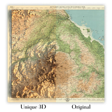
For something truly unique, this map is also available in "Unique 3D", our trademarked process that dramatically transforms the map so that it has a wonderful sense of depth. We combine the original map with detailed topography and elevation data, so that mountains and the terrain really "pop". For more info and examples of 3D maps, check my Unique 3D page.
Egypt and the Nile is the resonant title that crowns J. G. John George Bartholomew’s 1922 vision of the riverine heart of North Africa, created at the Edinburgh Geographical Institute and produced by John Bartholomew & Son, Ltd. Issued for The Times atlas—the unrivalled standard-bearer of accuracy—this second issue of the 1920 edition carries forward a tradition first launched in 1895, yet unmistakably embraces a modern cartographic idiom. An ornate cartouche anchors the composition, while crisp, hierarchical lettering and methodical color organize an immense body of geographical knowledge. The result is a map poised between the late Victorian appetite for grandeur and the early twentieth century’s scientific clarity, distilling Egypt’s physical drama and political realities into a single, authoritative image.
Bartholomew renders the land with hypsometric tints that sweep from the cool greens of the Nile’s fecund ribbon to the sun-burnished ochres of the Western and Eastern Deserts, punctuated by spot heights that pick out escarpments and the austere ridges of Sinai. Bathymetric shading deepens the surrounding seas, revealing continental shelves in the Mediterranean and the narrow trench of the Red Sea. The Nile is followed from the bifurcated Delta and its two great mouths to the cataract country near Aswan, threading past Cairo and Giza before turning through the corridor of antiquity. To the north and east, Alexandria, Port Said, and Suez are set with crystalline precision, and the Suez Canal—with its Bitter Lakes—forms the pivotal artery linking Mediterranean trade to the Indian Ocean.
Maritime and communications history animates the sheet. Finely ruled shipping routes stitch the Mediterranean to the Red Sea, converging upon Port Said and Suez before sweeping down toward the Aden region and beyond to the Indian Ocean world. Along these arcs, measured distances speak to the tempo of steam, charting the age of regular timetables and coaling schedules. Submarine cable pathways, the nervous system of empire and commerce, spear outward from Alexandria into the Levant and Europe, and from Suez toward the Arabian Sea, inscribing the invisible threads that compressed continents into hours. On the river itself, marked steamer tracks attest to Nile navigation, a seasonal choreography negotiating barrages and cataracts to bind Upper and Lower Egypt into a single economic spine.
The political framework is drawn with lucid economy. Clearly labeled boundaries delineate Egypt’s borders and internal divisions, while the long southern frontier with Anglo‑Egyptian Sudan is traced with the cartographic assurance that characterized the period. The Sinai land bridge is set apart by both color and relief, emphasizing its role as hinge between Africa and Asia. Insets focused on Alexandria and its environs amplify the story: breakwaters, harbor basins, railheads, and canalized waterways are articulated to reveal the city’s industrial and maritime reach across the Delta. Urban names constellate along the littoral and within the Delta’s lattice of channels, from the approaches to Port Said to the shoulders of Rosetta and Damietta, mapping a landscape where antiquity and modern infrastructure entwine.
Behind the clarity lies Bartholomew’s mature craft: the refined layer-coloring he championed; the disciplined typography that sorts cities, rivers, and relief at a glance; and the Edinburgh Geographical Institute’s exacting engraving tradition. As a contribution to The Times atlas, it epitomizes the early twentieth century’s shift from heroic exploration to administered connectivity—railways, telegraphs, canals, and standardized sea-lanes—without sacrificing aesthetic grace. Scholars and collectors prize such work for the way it compresses multiple narratives into one intelligible surface: the hydraulics of the Nile, the geopolitics of the Canal Zone, the mesh of submarine cables, and the lived geography of Cairo, Alexandria, Giza, Port Said, and Suez. It is a learned, elegant statement of Egypt’s centrality to a newly networked world.
Cities and towns on this map
- Cairo (modern population: ~9 million)
- Alexandria (modern population: ~5 million)
- Giza (modern population: ~2 million)
- Port Said (modern population: ~750,000)
- Suez (modern population: ~750,000)
Notable Features & Landmarks
- Hypsometric tints showing elevation changes
- Bathymetric tints denoting underwater depths
- Shipping routes marked across the Nile and surrounding waters
- Submarine cable pathways illustrated
- Spot heights indicating specific elevations
- Inset maps providing additional geographic details of Alexandria and surroundings
- Clearly labeled political boundaries
Historical and design context
- Mapmaker and Publisher: Created by J G John George Bartholomew in 1922; published by the Edinburgh Geographical Institute and produced by John Bartholomew & Son, Ltd.
- Historical Context: This map is part of "The Times" atlas, known for its accuracy and detail. It represents a transition in cartographic style, as it is the second issue of the 1920 edition; the original was released in 1895.
- Topics and Themes: The map illustrates both physical and political features of Egypt and the Nile, focusing on shipping routes, submarine cable pathways, and distances, showcasing maritime navigation history.
- Design and Style: The map includes relief representation through hypsometric tints and spot heights, with bathymetric tints to denote underwater depths. It features a clear and ornate cartouche, typical of Bartholomew's later work.
- Historical Significance: Highlights changes in cartographic practices and map-making techniques during the early 20th century, and serves as an important educational resource for historical research.
Please double check the images to make sure that a specific town or place is shown on this map. You can also get in touch and ask us to check the map for you.
This map looks great at every size, but I always recommend going for a larger size if you have space. That way you can easily make out all of the details.
This map looks amazing at sizes all the way up to 70in (180cm). If you are looking for a larger map, please get in touch.
Please note: the labels on this map are hard to read if you order a map that is 16in (40cm) or smaller. The map is still very attractive, but if you would like to read the map easily, please buy a larger size.
The model in the listing images is holding the 18x24in (45x60cm) version of this map.
The fifth listing image shows an example of my map personalisation service.
If you’re looking for something slightly different, check out my collection of the best old maps to see if something else catches your eye.
Please contact me to check if a certain location, landmark or feature is shown on this map.
This would make a wonderful birthday, Christmas, Father's Day, work leaving, anniversary or housewarming gift for someone from the areas covered by this map.
This map is available as a giclée print on acid free archival matte paper, or you can buy it framed. The frame is a nice, simple black frame that suits most aesthetics. Please get in touch if you'd like a different frame colour or material. My frames are glazed with super-clear museum-grade acrylic (perspex/acrylite), which is significantly less reflective than glass, safer, and will always arrive in perfect condition.
This map is also available as a float framed canvas, sometimes known as a shadow gap framed canvas or canvas floater. The map is printed on artist's cotton canvas and then stretched over a handmade box frame. We then "float" the canvas inside a wooden frame, which is available in a range of colours (black, dark brown, oak, antique gold and white). This is a wonderful way to present a map without glazing in front. See some examples of float framed canvas maps and explore the differences between my different finishes.
For something truly unique, this map is also available in "Unique 3D", our trademarked process that dramatically transforms the map so that it has a wonderful sense of depth. We combine the original map with detailed topography and elevation data, so that mountains and the terrain really "pop". For more info and examples of 3D maps, check my Unique 3D page.
Many of our maps and art prints are chosen as thoughtful gifts for homes, offices, studies and meaningful places.
Choose a framed option for the easiest ready-to-hang gift, or choose an unframed print if the recipient may prefer to select their own frame.
We make orders locally in 23 countries around the world, so gifts can often be produced close to the recipient. This helps them arrive faster, travel more safely, and avoid customs or import duty surprises.
- We can deliver directly to the recipient
- Framed pieces arrive ready to hang
- Unframed prints are carefully packed in a strong protective tube
- Almost every order is made locally, for faster, safer gifting
- 90-day returns give the recipient time to decide
If you are not sure what to choose, please contact us. We can help you pick the right map, size, finish or delivery option.
Für die meisten Bestellungen beträgt die Lieferzeit etwa 3 Werktage. Personalisierte und maßgeschneiderte Produkte benötigen länger, da ich die Personalisierung durchführen und sie Ihnen zur Genehmigung zusenden muss, was normalerweise 1 oder 2 Tage dauert.
Bitte beachten Sie, dass sehr große gerahmte Bestellungen in der Regel länger für die Herstellung und Lieferung benötigen.
Wenn Sie möchten, dass Ihre Bestellung bis zu einem bestimmten Datum ankommt, bitte kontaktieren Sie mich, bevor Sie bestellen, damit wir den besten Weg finden können, um sicherzustellen, dass Sie Ihre Bestellung rechtzeitig erhalten.
Ich drucke und rahme Karten und Kunstwerke in 23 Ländern weltweit. Das bedeutet, dass Ihre Bestellung lokal gefertigt wird, was die Lieferzeit verkürzt und sicherstellt, dass sie während der Lieferung nicht beschädigt wird. Sie zahlen nie Zoll oder Einfuhrgebühren, und wir stoßen weniger CO2 in die Luft aus.
Alle meine Karten und Kunstdrucke sind gut verpackt und werden in einem robusten Rohr versendet, wenn sie ungerahmt sind, oder von Schaum umgeben, wenn sie gerahmt sind.
Ich versuche, alle Bestellungen innerhalb von 1 oder 2 Tagen nach Erhalt Ihrer Bestellung zu versenden, obwohl einige Produkte (wie Gesichtsmasken, Tassen und Tragetaschen) länger zur Herstellung benötigen können.
Wenn Sie Express-Lieferung an der Kasse auswählen, priorisieren wir Ihre Bestellung und versenden sie per 1-Tages-Kurier (Fedex, DHL, UPS, Parcelforce).
Nächster Tag Lieferung ist auch in einigen Ländern verfügbar (USA, UK, Singapur, VAE), aber bitte versuchen Sie, früh am Tag zu bestellen, damit wir es rechtzeitig versenden können.
Lesen Sie meinen vollständigen Leitfaden zur Lieferung und lokalen Produktion
Mein Standardrahmen ist ein Galerie-Stil-Rahmen aus schwarzem Eschenholz. Er ist einfach und sieht ziemlich modern aus. Mein Standardrahmen ist etwa 20 mm (0,8 Zoll) breit.
Ich verwende super-klares Acryl (Plexiglas/Acrylt) für das Glas des Rahmens. Es ist leichter und sicherer als Glas – und es sieht besser aus, da die Reflexion geringer ist.
Sechs Standardrahmenfarben sind kostenlos erhältlich (schwarz, dunkelbraun, dunkelgrau, Eiche, weiß und antikgold).
Die meisten Karten, Kunstwerke und Illustrationen sind auch als gerahmte Leinwand erhältlich. Wir verwenden matte (nicht glänzende) Baumwollleinwand, spannen sie über einen nachhaltig beschafften Buchenrahmen und 'schweben' dann das Stück innerhalb eines Holzrahmens. Das Endergebnis ist ziemlich schön, und es gibt keine Verglasung, die im Weg ist.
Alle Rahmen werden "bereit zum Aufhängen" geliefert, entweder mit einer Schnur oder Halterungen auf der Rückseite. Sehr große Rahmen haben schwere Aufhängeplatten und/oder eine Montageschiene. Wenn Sie Fragen haben, können Sie bitte Kontakt aufnehmen.
Sehen Sie sich einige Beispiele meiner gerahmten Karten und gerahmten Leinwandkarten an.
Alternativ kann ich auch alte Karten und Kunstwerke auf Leinwand, Schaumstoffplatten, Baumwollrag und andere Materialien liefern.
Wenn Sie Ihre Karte oder Ihr Kunstwerk selbst rahmen möchten, lesen Sie bitte zuerst meinen Größenleitfaden.
Meine Karten sind äußerst hochwertige Reproduktionen von Originalkarten.
Ich beziehe originale, seltene Karten aus Bibliotheken, Auktionshäusern und Privatsammlungen auf der ganzen Welt, restauriere sie in meiner Londoner Werkstatt und erstelle dann mit speziellen Giclée-Tinten und -Druckern wunderschöne Karten, die sogar noch besser aussehen als das Original.
Meine Karten werden auf säurefreiem, mattem Archivpapier (nicht glänzend) gedruckt, das sich sehr hochwertig anfühlt und fast wie Karton aussieht. Technisch gesehen beträgt das Papiergewicht/die Papierdicke 10mil/200g/m². Es eignet sich perfekt zum Einrahmen.
Ich drucke mit UV-lichtbeständigen Ultrachrome-Giclée-Pigmenttinten von Epson – einige der besten Tinten, die Sie finden können.
Ich kann auch machen Karten auf Leinwand, Baumwolllappen und andere exotische Materialien.
Erfahren Sie mehr über The Unique Maps Co.
Kartenpersonalisierung
Wenn Sie nach dem perfekten Geschenk zum Jahrestag oder zur Einweihung suchen, kann ich Ihre Karte personalisieren, um sie wirklich einzigartig zu machen. Ich kann beispielsweise eine kurze Nachricht hinzufügen, einen wichtigen Ort hervorheben oder das Wappen Ihrer Familie hinzufügen.
Die Möglichkeiten sind nahezu unbegrenzt. Bitte sehen Sie sich meine Kartenpersonalisierungsseite für einige wunderbare Beispiele dessen, was möglich ist.
Um eine personalisierte Karte zu bestellen, wählen Sie „Personalisieren Sie Ihre Karte“, bevor Sie sie in den Warenkorb legen.
In Kontakt kommen wenn Sie nach komplexeren Anpassungen und Personalisierungen suchen.
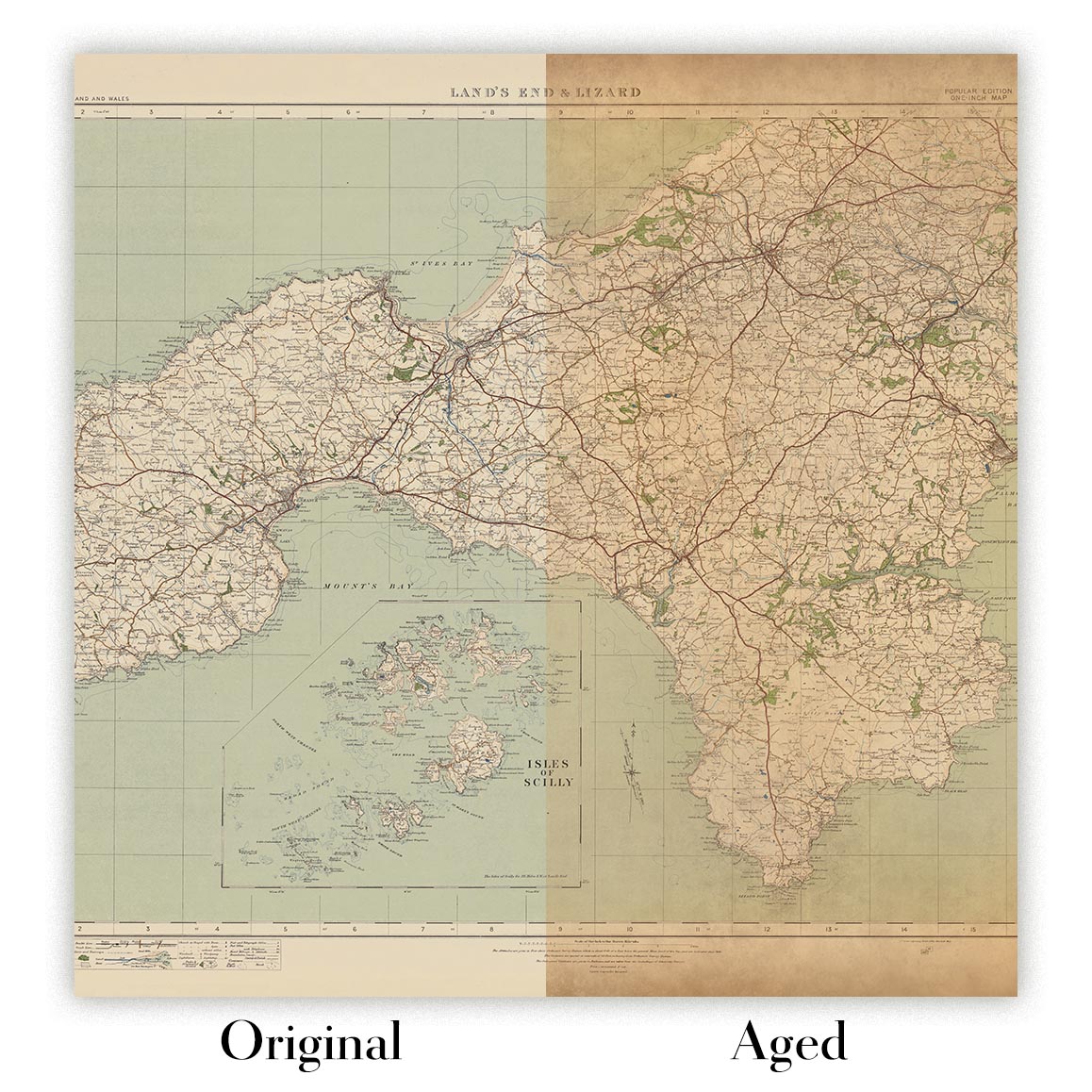
Kartenalterung
Im Laufe der Jahre wurde ich von Kunden hunderte Male gefragt, ob sie eine Karte kaufen könnten, die noch älter.
Nun, jetzt können Sie das, indem Sie „Alter“ auswählen, bevor Sie eine Karte in Ihren Warenkorb legen.
Alle Produktfotos, die Sie auf dieser Seite sehen, zeigen die Karte in ihrer Originalform. So sieht die Karte heute aus.
Wenn Sie „Gealtert“ auswählen, werde ich Ihre Karte von Hand altern lassen. Dazu verwende ich ein spezielles und einzigartiges Verfahren, das ich durch jahrelanges Studium alter Karten und Gespräche mit Forschern zum Verständnis der Chemie alternder Papiere entwickelt habe, und natürlich ... viel Übung!
Wenn Sie sich nicht sicher sind, bleiben Sie bei der Originalfarbe der Karte. Wenn Sie etwas Dunkleres und älter Wenn Sie auf der Suche sind, entscheiden Sie sich für „Aged“.
Sehen Sie einige erstaunliche Beispiele für gealterte Karten.
Wenn Sie aus irgendeinem Grund mit Ihrer Bestellung nicht zufrieden sind, kontaktieren Sie mich für eine unkomplizierte Rückerstattung. Bitte sehen Sie sich unsere Rückgabe- und Rückerstattungsrichtlinien für weitere Informationen an.
Ich bin sehr zuversichtlich, dass Ihnen Ihre restaurierte Karte oder Kunstdruck gefallen wird. Ich mache das seit 1984. Ich bin ein 5-Sterne Etsy-Verkäufer. Ich habe Zehntausende von Karten und Kunstdrucken verkauft und habe über 5.000 echte 5-Sterne-Bewertungen.
Ich verwende einen einzigartigen Prozess, um Karten und Kunstwerke zu restaurieren, der extrem zeitaufwendig und arbeitsintensiv ist. Die Suche nach den Originalkarten und Illustrationen kann Monate dauern. Ich benutze modernste und unglaublich teure Technologie, um sie zu scannen und wiederherzustellen. Daher garantiere ich, dass meine Karten und Kunstdrucke eine Klasse für sich sind - deshalb kann ich eine unkomplizierte Rückerstattung anbieten.
Fast alle meine Karten und Kunstdrucke sehen in großen Größen (200 cm, 6,5 Fuß+) erstaunlich aus und ich kann sie Ihnen auch gerahmt und über einen speziellen Übergrößen-Kurier liefern. Kontaktieren Sie mich, um Ihre speziellen Bedürfnisse zu besprechen.
Or try searching for something!


