


Alte Mercator-Weltkarte, die die Entdeckungen von Kapitän Cook zeigt, von Carey, 1814: Pazifik zentriert
Das Sammlerangebot
Wählen Sie zwei berechtigte Werke und erhalten Sie auf beide 20 % Rabatt. Wählen Sie drei, und das günstigste ist kostenlos – eine maximale Ersparnis von 33 %.
Kombinieren Sie berechtigte Standardkarten und Kunstdrucke nach Belieben. Kein Code erforderlich; das Angebot wird an der Kasse automatisch angewendet.
Standardmäßige Konfigurationen nach Maßanfertigung sind inbegriffen. Maßgeschneiderte Größen, personalisierte Entwürfe und Auftragsarbeiten sind ausgeschlossen.
Benötigen Sie die Lieferung an unterschiedliche Adressen? Kontaktieren Sie uns vor der Bestellung.Das Sammlerangebot
Wählen Sie zwei berechtigte Werke und erhalten Sie auf beide 20 % Rabatt. Wählen Sie drei, und das günstigste ist kostenlos – eine maximale Ersparnis von 33 %.
Kombinieren Sie berechtigte Standardkarten und Kunstdrucke nach Belieben. Kein Code erforderlich; das Angebot wird an der Kasse automatisch angewendet.
Standardmäßige Konfigurationen nach Maßanfertigung sind inbegriffen. Maßgeschneiderte Größen, personalisierte Entwürfe und Auftragsarbeiten sind ausgeschlossen.
Benötigen Sie die Lieferung an unterschiedliche Adressen? Kontaktieren Sie uns vor der Bestellung. In London gestaltet Hergestellt in der EU
In London gestaltet • Hergestellt in der EU
In London gestaltet Hergestellt in der EU
In London gestaltet • Hergestellt in der EU

Aus der Originalkarte von 1814 restauriert und in Museumsqualität gedruckt. Die Geschichte hinter dieser Karte lesen
Choose your size
Choose your finish


(Mehr Infos)
Geschenkmitteilung & individuelle Ausführung

Wenn Sie eine Geschenkmitteilung oder eine Ausführung (Puzzle, Aluminiumplatte usw.) hinzufügen möchten, die hier nicht verfügbar ist, geben Sie dies bitte in der "Bestellnotiz" beim Checkout an.
Jede Bestellung wird individuell angefertigt. Wenn Sie die Größe leicht anpassen oder auf einem ungewöhnlichen Material drucken lassen möchten, lassen Sie es uns einfach wissen. Wir haben im Laufe der Jahre Tausende von individuellen Bestellungen bearbeitet, daher gibt es (fast) nichts, was wir nicht bewältigen können.
Sie können uns auch kontaktieren, bevor Sie bestellen, wenn Sie möchten!

- Lokal gefertigt. Sicher geliefert
- Keine Zölle oder versteckten Gebühren
- Hilfe nötig? Rufen Sie uns an oder WhatsApp schreiben
Own a piece of history
8,000+ five-star reviews


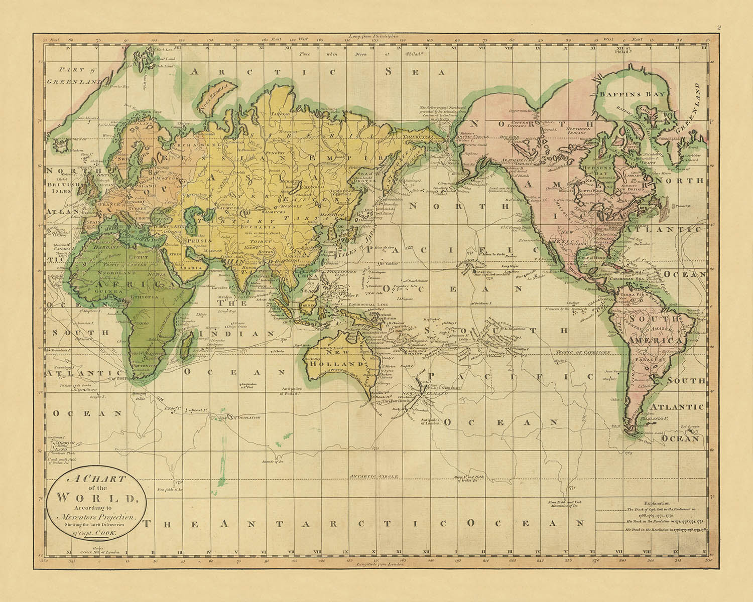
Betreten Sie die faszinierende Welt der Erkundungen des frühen 19. Jahrhunderts mit "Eine Karte der Welt gemäß Mercators Projektion. Zeigt die neuesten...
WeiterlesenBetreten Sie die faszinierende Welt der Erkundungen des frühen 19. Jahrhunderts mit "Eine Karte der Welt gemäß Mercators Projektion. Zeigt die neuesten Entdeckungen von Kapitän Cook." Diese Karte, die von dem angesehenen amerikanischen Kartografen Mathew Carey im Jahr 1814 erstellt wurde, ist ein Zeugnis des Zeitalters der Entdeckungen und des Abenteuers. Als eine der ersten Weltkarten, die in Amerika gedruckt wurden, fängt sie das Wesen einer Ära ein, in der die Welt noch kartiert und verstanden wurde. Careys Werk spiegelt die aufstrebende amerikanische kartografische Tradition wider und kombiniert Kunstfertigkeit mit wissenschaftlicher Forschung.
Die Karte ist eine visuelle Erzählung von Kapitän James Cooks legendären Reisen, die sorgfältig mit klaren Linien kartiert sind, die seine Routen über den Globus nachzeichnen. Diese Reisen, die die Grenzen der bekannten Geographie erweiterten, sind hier verewigt und bieten einen Einblick in die Herausforderungen und Triumphe der Erkundung. Die Karte dokumentiert nicht nur Cooks Pfade, sondern hebt auch Gebiete der Welt hervor, die noch im Dunkeln lagen, und lädt die Betrachter ein, sich die unerforschten Territorien vorzustellen, die jenseits lagen.
Gestaltet mit Mercators Projektion, präsentiert die Karte eine harmonische Mischung aus ästhetischem Reiz und funktionaler Genauigkeit. Ihre ursprüngliche Färbung, eine Seltenheit für Karten dieser Zeit, fügt eine Schicht von Reichtum und Tiefe hinzu und verstärkt ihre visuelle Anziehungskraft. Der Stil der Karte erinnert an Ausgaben, die in Guthries Geographie zu finden sind, was auf eine gemeinsame Abstammung der für den Druck verwendeten Platten hindeutet. Diese Verbindung unterstreicht die kollaborative Natur der Kartografie in dieser Zeit, da Kartografen auf den Arbeiten anderer aufbauten, um das Verständnis der Welt zu verfeinern und zu erweitern.
Die geografischen Details auf der Karte offenbaren das sich entwickelnde Wissen der Zeit. Van Diemens Land wird als Teil Australiens dargestellt, während die primitive Form Neuseelands auf die frühen Stadien seiner kartografischen Darstellung hinweist. Die Nordwestküste Amerikas und die arktischen Regionen sind mit spekulativen Linien markiert, die die begrenzte Erkundung dieser Gebiete widerspiegeln. Anmerkungen zu Eisfeldern rund um den Antarktischen Kreis und Cooks weitestem nördlichen Punkt im Juli 1779 fügen historische Kontexte hinzu und machen die Karte zu einem reichen Gewebe von Erkundungserzählungen.
Diese Karte ist mehr als nur eine Darstellung der Welt; sie ist ein historisches Artefakt, das den Geist der Entdeckung verkörpert. Sie lädt den Betrachter ein, in eine Zeit zurückzukehren, als die Welt noch enthüllt wurde, eine Reise nach der anderen. Ob Sie ein Sammler, ein Geschichtsinteressierter oder einfach nur von der Kunst der Kartografie fasziniert sind, diese Karte bietet ein einzigartiges Fenster in die Vergangenheit, in der jede Linie und Anmerkung eine Geschichte von Abenteuer, Neugier und dem unermüdlichen Streben nach Wissen erzählt.
Länder und Regionen auf dieser Karte
- Kontinente:
- Nordamerika
- Südamerika
- Europa
- Afrika
- Asien
- Australien
- Regionen:
- Grönland
- Van Diemens Land (Tasmanien)
- Neuseeland
- Nordwestküste Amerikas
- Arktischer Kreis
- Antarktischer Kreis
Bemerkenswerte Merkmale & Wahrzeichen
- Gewässer:
- Der Arktische Ozean, der Atlantische Ozean, der Indische Ozean und der Pazifische Ozean sind beschriftet.
- Historische Anmerkungen:
- Die Routen von Kapitän Cook sind mit verschiedenen Arten von Linien markiert.
- Anmerkungen zu Cooks weitestem nördlichen Punkt im Juli 1779.
- Eisfelder, die rund um den Antarktischen Kreis angetroffen wurden.
- Weitere Merkmale:
- Die Karte enthält eine Erklärung der Linien, die verwendet werden, um Cooks Reisen zu kennzeichnen.
- Annotationen zu geografischen Unsicherheiten und hypothetischen Gebieten.
Historischer und gestalterischer Kontext
- Erstellt von: Mathew Carey im Jahr 1814.
- Historische Bedeutung:
- Eine der ersten Weltkarten, die in Amerika gedruckt wurden.
- Spiegelt das geografische Wissen und die Erkundungen des frühen 19. Jahrhunderts wider.
- Design und Stil:
- Verwendet die Mercator-Projektion.
- Besitzt die originale Farbe, die für Karten aus dieser Zeit selten ist.
- Ähnlich einer Ausgabe in Guthries Geographie, möglicherweise von derselben Platte gedruckt.
- Themen und Themen:
- Erkundung und Entdeckung, die die Reisen von Captain Cook hervorhebt.
- Die Karte enthält hypothetische Gebiete, die das begrenzte Wissen über bestimmte Regionen zu dieser Zeit widerspiegeln.
Bitte überprüfen Sie die Bilder, um sicherzustellen, dass eine bestimmte Stadt oder ein bestimmter Ort auf dieser Karte angezeigt wird. Sie können uns auch kontaktieren und bitten, die Karte für Sie zu überprüfen.
Diese Karte sieht in jeder Größe großartig aus, aber ich empfehle immer, eine größere Größe zu wählen, wenn Sie Platz haben. So können Sie alle Details leicht erkennen.
Diese Karte sieht in Größen bis zu 70 Zoll (180 cm) erstaunlich aus. Wenn Sie nach einer größeren Karte suchen, bitte kontaktieren Sie uns.
Das Modell in den Angebotsbildern hält die 16x20 Zoll (40x50 cm) Version dieser Karte.
Das fünfte Angebotsbild zeigt ein Beispiel für meinen Personalisierungsservice für Karten.
Wenn Sie nach etwas leicht anderem suchen, schauen Sie sich meine Sammlung der besten alten Karten an, um zu sehen, ob etwas anderes Ihr Interesse weckt.
Bitte kontaktieren Sie mich, um zu überprüfen, ob ein bestimmter Standort, Wahrzeichen oder Merkmal auf dieser Karte angezeigt wird.
Dies wäre ein wunderbares Geschenk zum Geburtstag, Weihnachten, Vatertag, Abschied von der Arbeit, Jubiläum oder Einweihung für jemanden aus den Gebieten, die von dieser Karte abgedeckt werden.
Diese Karte ist als Giclée-Druck auf säurefreiem, archiviertem mattem Papier erhältlich, oder Sie können sie gerahmt kaufen. Der Rahmen ist ein schöner, einfacher schwarzer Rahmen, der zu den meisten Ästhetiken passt. Bitte kontaktieren Sie mich, wenn Sie eine andere Rahmenfarbe oder -material wünschen. Meine Rahmen sind mit superklarem museumsglasähnlichem Acryl (Plexiglas/Acrylit) verglast, das deutlich weniger reflektierend ist als Glas, sicherer ist und immer in perfektem Zustand ankommt.
This map is also available as a float framed canvas, sometimes known as a shadow gap framed canvas or canvas floater. The map is printed on artist's cotton canvas and then stretched over a handmade box frame. We then "float" the canvas inside a wooden frame, which is available in a range of colours (black, dark brown, oak, antique gold and white). This is a wonderful way to present a map without glazing in front. See some examples of float framed canvas maps and explore the differences between my different finishes.
For something truly unique, this map is also available in "Unique 3D", our trademarked process that dramatically transforms the map so that it has a wonderful sense of depth. We combine the original map with detailed topography and elevation data, so that mountains and the terrain really "pop". For more info and examples of 3D maps, check my Unique 3D page.
Betreten Sie die faszinierende Welt der Erkundungen des frühen 19. Jahrhunderts mit "Eine Karte der Welt gemäß Mercators Projektion. Zeigt die neuesten Entdeckungen von Kapitän Cook." Diese Karte, die von dem angesehenen amerikanischen Kartografen Mathew Carey im Jahr 1814 erstellt wurde, ist ein Zeugnis des Zeitalters der Entdeckungen und des Abenteuers. Als eine der ersten Weltkarten, die in Amerika gedruckt wurden, fängt sie das Wesen einer Ära ein, in der die Welt noch kartiert und verstanden wurde. Careys Werk spiegelt die aufstrebende amerikanische kartografische Tradition wider und kombiniert Kunstfertigkeit mit wissenschaftlicher Forschung.
Die Karte ist eine visuelle Erzählung von Kapitän James Cooks legendären Reisen, die sorgfältig mit klaren Linien kartiert sind, die seine Routen über den Globus nachzeichnen. Diese Reisen, die die Grenzen der bekannten Geographie erweiterten, sind hier verewigt und bieten einen Einblick in die Herausforderungen und Triumphe der Erkundung. Die Karte dokumentiert nicht nur Cooks Pfade, sondern hebt auch Gebiete der Welt hervor, die noch im Dunkeln lagen, und lädt die Betrachter ein, sich die unerforschten Territorien vorzustellen, die jenseits lagen.
Gestaltet mit Mercators Projektion, präsentiert die Karte eine harmonische Mischung aus ästhetischem Reiz und funktionaler Genauigkeit. Ihre ursprüngliche Färbung, eine Seltenheit für Karten dieser Zeit, fügt eine Schicht von Reichtum und Tiefe hinzu und verstärkt ihre visuelle Anziehungskraft. Der Stil der Karte erinnert an Ausgaben, die in Guthries Geographie zu finden sind, was auf eine gemeinsame Abstammung der für den Druck verwendeten Platten hindeutet. Diese Verbindung unterstreicht die kollaborative Natur der Kartografie in dieser Zeit, da Kartografen auf den Arbeiten anderer aufbauten, um das Verständnis der Welt zu verfeinern und zu erweitern.
Die geografischen Details auf der Karte offenbaren das sich entwickelnde Wissen der Zeit. Van Diemens Land wird als Teil Australiens dargestellt, während die primitive Form Neuseelands auf die frühen Stadien seiner kartografischen Darstellung hinweist. Die Nordwestküste Amerikas und die arktischen Regionen sind mit spekulativen Linien markiert, die die begrenzte Erkundung dieser Gebiete widerspiegeln. Anmerkungen zu Eisfeldern rund um den Antarktischen Kreis und Cooks weitestem nördlichen Punkt im Juli 1779 fügen historische Kontexte hinzu und machen die Karte zu einem reichen Gewebe von Erkundungserzählungen.
Diese Karte ist mehr als nur eine Darstellung der Welt; sie ist ein historisches Artefakt, das den Geist der Entdeckung verkörpert. Sie lädt den Betrachter ein, in eine Zeit zurückzukehren, als die Welt noch enthüllt wurde, eine Reise nach der anderen. Ob Sie ein Sammler, ein Geschichtsinteressierter oder einfach nur von der Kunst der Kartografie fasziniert sind, diese Karte bietet ein einzigartiges Fenster in die Vergangenheit, in der jede Linie und Anmerkung eine Geschichte von Abenteuer, Neugier und dem unermüdlichen Streben nach Wissen erzählt.
Länder und Regionen auf dieser Karte
- Kontinente:
- Nordamerika
- Südamerika
- Europa
- Afrika
- Asien
- Australien
- Regionen:
- Grönland
- Van Diemens Land (Tasmanien)
- Neuseeland
- Nordwestküste Amerikas
- Arktischer Kreis
- Antarktischer Kreis
Bemerkenswerte Merkmale & Wahrzeichen
- Gewässer:
- Der Arktische Ozean, der Atlantische Ozean, der Indische Ozean und der Pazifische Ozean sind beschriftet.
- Historische Anmerkungen:
- Die Routen von Kapitän Cook sind mit verschiedenen Arten von Linien markiert.
- Anmerkungen zu Cooks weitestem nördlichen Punkt im Juli 1779.
- Eisfelder, die rund um den Antarktischen Kreis angetroffen wurden.
- Weitere Merkmale:
- Die Karte enthält eine Erklärung der Linien, die verwendet werden, um Cooks Reisen zu kennzeichnen.
- Annotationen zu geografischen Unsicherheiten und hypothetischen Gebieten.
Historischer und gestalterischer Kontext
- Erstellt von: Mathew Carey im Jahr 1814.
- Historische Bedeutung:
- Eine der ersten Weltkarten, die in Amerika gedruckt wurden.
- Spiegelt das geografische Wissen und die Erkundungen des frühen 19. Jahrhunderts wider.
- Design und Stil:
- Verwendet die Mercator-Projektion.
- Besitzt die originale Farbe, die für Karten aus dieser Zeit selten ist.
- Ähnlich einer Ausgabe in Guthries Geographie, möglicherweise von derselben Platte gedruckt.
- Themen und Themen:
- Erkundung und Entdeckung, die die Reisen von Captain Cook hervorhebt.
- Die Karte enthält hypothetische Gebiete, die das begrenzte Wissen über bestimmte Regionen zu dieser Zeit widerspiegeln.
Bitte überprüfen Sie die Bilder, um sicherzustellen, dass eine bestimmte Stadt oder ein bestimmter Ort auf dieser Karte angezeigt wird. Sie können uns auch kontaktieren und bitten, die Karte für Sie zu überprüfen.
Diese Karte sieht in jeder Größe großartig aus, aber ich empfehle immer, eine größere Größe zu wählen, wenn Sie Platz haben. So können Sie alle Details leicht erkennen.
Diese Karte sieht in Größen bis zu 70 Zoll (180 cm) erstaunlich aus. Wenn Sie nach einer größeren Karte suchen, bitte kontaktieren Sie uns.
Das Modell in den Angebotsbildern hält die 16x20 Zoll (40x50 cm) Version dieser Karte.
Das fünfte Angebotsbild zeigt ein Beispiel für meinen Personalisierungsservice für Karten.
Wenn Sie nach etwas leicht anderem suchen, schauen Sie sich meine Sammlung der besten alten Karten an, um zu sehen, ob etwas anderes Ihr Interesse weckt.
Bitte kontaktieren Sie mich, um zu überprüfen, ob ein bestimmter Standort, Wahrzeichen oder Merkmal auf dieser Karte angezeigt wird.
Dies wäre ein wunderbares Geschenk zum Geburtstag, Weihnachten, Vatertag, Abschied von der Arbeit, Jubiläum oder Einweihung für jemanden aus den Gebieten, die von dieser Karte abgedeckt werden.
Diese Karte ist als Giclée-Druck auf säurefreiem, archiviertem mattem Papier erhältlich, oder Sie können sie gerahmt kaufen. Der Rahmen ist ein schöner, einfacher schwarzer Rahmen, der zu den meisten Ästhetiken passt. Bitte kontaktieren Sie mich, wenn Sie eine andere Rahmenfarbe oder -material wünschen. Meine Rahmen sind mit superklarem museumsglasähnlichem Acryl (Plexiglas/Acrylit) verglast, das deutlich weniger reflektierend ist als Glas, sicherer ist und immer in perfektem Zustand ankommt.
This map is also available as a float framed canvas, sometimes known as a shadow gap framed canvas or canvas floater. The map is printed on artist's cotton canvas and then stretched over a handmade box frame. We then "float" the canvas inside a wooden frame, which is available in a range of colours (black, dark brown, oak, antique gold and white). This is a wonderful way to present a map without glazing in front. See some examples of float framed canvas maps and explore the differences between my different finishes.
For something truly unique, this map is also available in "Unique 3D", our trademarked process that dramatically transforms the map so that it has a wonderful sense of depth. We combine the original map with detailed topography and elevation data, so that mountains and the terrain really "pop". For more info and examples of 3D maps, check my Unique 3D page.
Many of our maps and art prints are chosen as thoughtful gifts for homes, offices, studies and meaningful places.
Choose a framed option for the easiest ready-to-hang gift, or choose an unframed print if the recipient may prefer to select their own frame.
We make orders locally in 23 countries around the world, so gifts can often be produced close to the recipient. This helps them arrive faster, travel more safely, and avoid customs or import duty surprises.
- We can deliver directly to the recipient
- Framed pieces arrive ready to hang
- Unframed prints are carefully packed in a strong protective tube
- Almost every order is made locally, for faster, safer gifting
- 90-day returns give the recipient time to decide
If you are not sure what to choose, please contact us. We can help you pick the right map, size, finish or delivery option.
Für die meisten Bestellungen beträgt die Lieferzeit etwa 3 Werktage. Personalisierte und maßgeschneiderte Produkte benötigen länger, da ich die Personalisierung durchführen und sie Ihnen zur Genehmigung zusenden muss, was normalerweise 1 oder 2 Tage dauert.
Bitte beachten Sie, dass sehr große gerahmte Bestellungen in der Regel länger für die Herstellung und Lieferung benötigen.
Wenn Sie möchten, dass Ihre Bestellung bis zu einem bestimmten Datum ankommt, bitte kontaktieren Sie mich, bevor Sie bestellen, damit wir den besten Weg finden können, um sicherzustellen, dass Sie Ihre Bestellung rechtzeitig erhalten.
Ich drucke und rahme Karten und Kunstwerke in 23 Ländern weltweit. Das bedeutet, dass Ihre Bestellung lokal gefertigt wird, was die Lieferzeit verkürzt und sicherstellt, dass sie während der Lieferung nicht beschädigt wird. Sie zahlen nie Zoll oder Einfuhrgebühren, und wir stoßen weniger CO2 in die Luft aus.
Alle meine Karten und Kunstdrucke sind gut verpackt und werden in einem robusten Rohr versendet, wenn sie ungerahmt sind, oder von Schaum umgeben, wenn sie gerahmt sind.
Ich versuche, alle Bestellungen innerhalb von 1 oder 2 Tagen nach Erhalt Ihrer Bestellung zu versenden, obwohl einige Produkte (wie Gesichtsmasken, Tassen und Tragetaschen) länger zur Herstellung benötigen können.
Wenn Sie Express-Lieferung an der Kasse auswählen, priorisieren wir Ihre Bestellung und versenden sie per 1-Tages-Kurier (Fedex, DHL, UPS, Parcelforce).
Nächster Tag Lieferung ist auch in einigen Ländern verfügbar (USA, UK, Singapur, VAE), aber bitte versuchen Sie, früh am Tag zu bestellen, damit wir es rechtzeitig versenden können.
Lesen Sie meinen vollständigen Leitfaden zur Lieferung und lokalen Produktion
Mein Standardrahmen ist ein Galerie-Stil-Rahmen aus schwarzem Eschenholz. Er ist einfach und sieht ziemlich modern aus. Mein Standardrahmen ist etwa 20 mm (0,8 Zoll) breit.
Ich verwende super-klares Acryl (Plexiglas/Acrylt) für das Glas des Rahmens. Es ist leichter und sicherer als Glas – und es sieht besser aus, da die Reflexion geringer ist.
Sechs Standardrahmenfarben sind kostenlos erhältlich (schwarz, dunkelbraun, dunkelgrau, Eiche, weiß und antikgold).
Die meisten Karten, Kunstwerke und Illustrationen sind auch als gerahmte Leinwand erhältlich. Wir verwenden matte (nicht glänzende) Baumwollleinwand, spannen sie über einen nachhaltig beschafften Buchenrahmen und 'schweben' dann das Stück innerhalb eines Holzrahmens. Das Endergebnis ist ziemlich schön, und es gibt keine Verglasung, die im Weg ist.
Alle Rahmen werden "bereit zum Aufhängen" geliefert, entweder mit einer Schnur oder Halterungen auf der Rückseite. Sehr große Rahmen haben schwere Aufhängeplatten und/oder eine Montageschiene. Wenn Sie Fragen haben, können Sie bitte Kontakt aufnehmen.
Sehen Sie sich einige Beispiele meiner gerahmten Karten und gerahmten Leinwandkarten an.
Alternativ kann ich auch alte Karten und Kunstwerke auf Leinwand, Schaumstoffplatten, Baumwollrag und andere Materialien liefern.
Wenn Sie Ihre Karte oder Ihr Kunstwerk selbst rahmen möchten, lesen Sie bitte zuerst meinen Größenleitfaden.
Meine Karten sind äußerst hochwertige Reproduktionen von Originalkarten.
Ich beziehe originale, seltene Karten aus Bibliotheken, Auktionshäusern und Privatsammlungen auf der ganzen Welt, restauriere sie in meiner Londoner Werkstatt und erstelle dann mit speziellen Giclée-Tinten und -Druckern wunderschöne Karten, die sogar noch besser aussehen als das Original.
Meine Karten werden auf säurefreiem, mattem Archivpapier (nicht glänzend) gedruckt, das sich sehr hochwertig anfühlt und fast wie Karton aussieht. Technisch gesehen beträgt das Papiergewicht/die Papierdicke 10mil/200g/m². Es eignet sich perfekt zum Einrahmen.
Ich drucke mit UV-lichtbeständigen Ultrachrome-Giclée-Pigmenttinten von Epson – einige der besten Tinten, die Sie finden können.
Ich kann auch machen Karten auf Leinwand, Baumwolllappen und andere exotische Materialien.
Erfahren Sie mehr über The Unique Maps Co.
Kartenpersonalisierung
Wenn Sie nach dem perfekten Geschenk zum Jahrestag oder zur Einweihung suchen, kann ich Ihre Karte personalisieren, um sie wirklich einzigartig zu machen. Ich kann beispielsweise eine kurze Nachricht hinzufügen, einen wichtigen Ort hervorheben oder das Wappen Ihrer Familie hinzufügen.
Die Möglichkeiten sind nahezu unbegrenzt. Bitte sehen Sie sich meine Kartenpersonalisierungsseite für einige wunderbare Beispiele dessen, was möglich ist.
Um eine personalisierte Karte zu bestellen, wählen Sie „Personalisieren Sie Ihre Karte“, bevor Sie sie in den Warenkorb legen.
In Kontakt kommen wenn Sie nach komplexeren Anpassungen und Personalisierungen suchen.
Kartenalterung
Im Laufe der Jahre wurde ich von Kunden hunderte Male gefragt, ob sie eine Karte kaufen könnten, die noch älter.
Nun, jetzt können Sie das, indem Sie „Alter“ auswählen, bevor Sie eine Karte in Ihren Warenkorb legen.
Alle Produktfotos, die Sie auf dieser Seite sehen, zeigen die Karte in ihrer Originalform. So sieht die Karte heute aus.
Wenn Sie „Gealtert“ auswählen, werde ich Ihre Karte von Hand altern lassen. Dazu verwende ich ein spezielles und einzigartiges Verfahren, das ich durch jahrelanges Studium alter Karten und Gespräche mit Forschern zum Verständnis der Chemie alternder Papiere entwickelt habe, und natürlich ... viel Übung!
Wenn Sie sich nicht sicher sind, bleiben Sie bei der Originalfarbe der Karte. Wenn Sie etwas Dunkleres und älter Wenn Sie auf der Suche sind, entscheiden Sie sich für „Aged“.
Sehen Sie einige erstaunliche Beispiele für gealterte Karten.
Wenn Sie aus irgendeinem Grund mit Ihrer Bestellung nicht zufrieden sind, kontaktieren Sie mich für eine unkomplizierte Rückerstattung. Bitte sehen Sie sich unsere Rückgabe- und Rückerstattungsrichtlinien für weitere Informationen an.
Ich bin sehr zuversichtlich, dass Ihnen Ihre restaurierte Karte oder Kunstdruck gefallen wird. Ich mache das seit 1984. Ich bin ein 5-Sterne Etsy-Verkäufer. Ich habe Zehntausende von Karten und Kunstdrucken verkauft und habe über 5.000 echte 5-Sterne-Bewertungen.
Ich verwende einen einzigartigen Prozess, um Karten und Kunstwerke zu restaurieren, der extrem zeitaufwendig und arbeitsintensiv ist. Die Suche nach den Originalkarten und Illustrationen kann Monate dauern. Ich benutze modernste und unglaublich teure Technologie, um sie zu scannen und wiederherzustellen. Daher garantiere ich, dass meine Karten und Kunstdrucke eine Klasse für sich sind - deshalb kann ich eine unkomplizierte Rückerstattung anbieten.
Fast alle meine Karten und Kunstdrucke sehen in großen Größen (200 cm, 6,5 Fuß+) erstaunlich aus und ich kann sie Ihnen auch gerahmt und über einen speziellen Übergrößen-Kurier liefern. Kontaktieren Sie mich, um Ihre speziellen Bedürfnisse zu besprechen.
Or try searching for something!


