


Alte Karte von Halifax, Neufundland, Nova Scotia & New Brunswick von Bartholomew, 1922
20% Rabatt auf 2 — 33% Rabatt auf 3
Fügen Sie beliebige zwei berechtigte Artikel zu Ihrem Warenkorb hinzu, um 20% Rabatt zu erhalten. Fügen Sie einen dritten hinzu und er ist kostenlos (entspricht 33% Rabatt, wenn Sie drei kaufen).
Kein Code erforderlich — das Angebot wird automatisch an der Kasse angewendet.
Gültig für alle Standardkarten und Kunstdrucke. Sie können beliebige Designs kombinieren.
Wenn Sie Artikel an mehrere Adressen versenden möchten, kontaktieren Sie uns bitte, bevor Sie Ihre Bestellung aufgeben.
Maßanfertigungen und individuelle Aufträge sind ausgeschlossen.
Kontaktieren Sie uns wenn Sie Fragen haben
 In London gestaltet Hergestellt in der EU
In London gestaltet • Hergestellt in der EU
In London gestaltet Hergestellt in der EU
In London gestaltet • Hergestellt in der EU

Aus der Originalkarte von 1922 restauriert und in Museumsqualität gedruckt. Die Geschichte hinter dieser Karte lesen
Choose your size
Choose your finish


(Mehr Infos)
Geschenkmitteilung & individuelle Ausführung

Wenn Sie eine Geschenkmitteilung oder eine Ausführung (Puzzle, Aluminiumplatte usw.) hinzufügen möchten, die hier nicht verfügbar ist, geben Sie dies bitte in der "Bestellnotiz" beim Checkout an.
Jede Bestellung wird individuell angefertigt. Wenn Sie die Größe leicht anpassen oder auf einem ungewöhnlichen Material drucken lassen möchten, lassen Sie es uns einfach wissen. Wir haben im Laufe der Jahre Tausende von individuellen Bestellungen bearbeitet, daher gibt es (fast) nichts, was wir nicht bewältigen können.
Sie können uns auch kontaktieren, bevor Sie bestellen, wenn Sie möchten!

- Lokal gefertigt. Sicher geliefert
- Keine Zölle oder versteckten Gebühren
- Hilfe nötig? Rufen Sie uns an oder WhatsApp schreiben
Own a piece of history
8,000+ five-star reviews


Tauchen Sie ein in das maritime Erbe Kanadas zu Beginn des zwanzigsten Jahrhunderts mit "Maritime Provinces & Newfoundland", einem meisterhaften kartografischen Werk...
WeiterlesenTauchen Sie ein in das maritime Erbe Kanadas zu Beginn des zwanzigsten Jahrhunderts mit "Maritime Provinces & Newfoundland", einem meisterhaften kartografischen Werk von 1922 des gefeierten John George Bartholomew. Diese exquisite Karte, die ursprünglich im angesehenen Times Atlas & Gazetteer of the World veröffentlicht wurde, markiert einen entscheidenden Übergang in der Kunst und Wissenschaft der Kartografie. Bartholomews Vision brachte eine neue Ära der Genauigkeit und Eleganz hervor, ersetzte die früheren Andree-Karten von 1895 und setzte einen neuen Standard für geographische Wissenschaft. Die detaillierte Darstellung der Maritimen Provinzen – Nova Scotia, New Brunswick, Prince Edward Island – und des damals unabhängigen Neufundlands fängt eine Region ein, die von Jahrhunderten der Seefahrt, des Handels und des kulturellen Austauschs geprägt ist.
Bartholomews Kunstfertigkeit wird sofort in der Verwendung von hypsometrischen Farbtönen deutlich, einer raffinierten Technik, die Farbverläufe nutzt, um die subtilen Erhebungen des Landes zu offenbaren. Die physische Geographie der Region wird lebendig, von den bewaldeten Cape Breton Highlands bis zu den sanften Hügeln und Flusstälern von New Brunswick. Bathymetrische Schattierungen bringen die umliegenden Meere scharf zur Geltung, wobei die dramatischen Tiefen der Bay of Fundy und des Golfs von St. Lawrence in fesselnden Details dargestellt werden. Die akribische Handkolorierung und elegante Typografie der Karte wecken das goldene Zeitalter der Atlasproduktion und machen sie sowohl zu einem Kunstwerk als auch zu einem Navigationswerkzeug.
Über ihre visuelle Anziehungskraft hinaus ist diese Karte ein Dokument eines transformierenden historischen Moments. Sie wurde erstellt, als Neufundland noch ein separates Dominion war, und präsentiert die politischen Grenzen und Landkreisaufteilungen einer Region, die am Vorabend des Wandels steht. Die markierten Schifffahrtsrouten, komplett mit präzisen Entfernungen, sprechen von der anhaltenden Bedeutung des maritimen Handels und den täglichen Rhythmen des Lebens, die vom Atlantik geprägt sind. Mit einem detaillierten Plan von Halifax – damals, wie heute, einer geschäftigen Hafenstadt – bietet die Karte sowohl einen grandiosen Überblick als auch eine fokussierte Studie eines der vitalsten städtischen Zentren der Region.
Die Oberfläche der Karte ist ein Wandteppich menschlicher Siedlungen und natürlicher Wunder. Von den geschichtsträchtigen Städten Halifax, Saint John und St. John’s bis zu den kleineren Städten, die die Küsten und Flussufer säumen, ist jede Gemeinde sorgfältig eingetragen und zeugt vom Wachstum und der Vielfalt der Maritimen Provinzen. Wichtige Flüsse wie der Saint John und Miramichi schneiden sich durch die Landschaft, während die komplexen Küstenlinien von Cape Breton Island, der Avalon-Halbinsel und Prince Edward Island mit der liebevollen Präzision eines Kartografen dargestellt sind. Bemerkenswerterweise spiegelt das Fehlen von Nationalparks oder historischen Wahrzeichen die zeitliche Fokussierung der Karte wider, doch das Land und das Meer selbst stehen als beständige Denkmäler des reichen natürlichen und kulturellen Erbes der Region.
John George Bartholomew, oft als „der Prinz der Kartografen“ bezeichnet, verlieh dieser Karte sowohl wissenschaftliche Strenge als auch künstlerische Anmut. Sein Pionierwerk in der thematischen und physischen Kartierung wird in vollem Umfang präsentiert und bietet einen Einblick in das sich entwickelnde Verständnis der östlichsten Provinzen Kanadas. Diese Karte ist nicht nur ein Dokument der Geographie – sie ist ein Zeugnis der intellektuellen Neugier, technischen Innovation und der zeitlosen Anziehungskraft der Erkundung in dieser Epoche. Für Sammler und Kenner ist "Maritime Provinces & Newfoundland" eine seltene Gelegenheit, ein Stück kartografischer Geschichte zu besitzen, das mit den Geschichten des Landes, des Meeres und der Menschen, die diese Region ihr Zuhause nennen, resoniert.
Städte und Gemeinden auf dieser Karte
- Nova Scotia
- Halifax
- Sydney
- Neues Glasgow
- Truro
- Amherst
- Kentville
- Yarmouth
- Bridgewater
- Antigonish
-
Windsor
-
New Brunswick
- Moncton
- Saint John
- Fredericton
- Bathurst
- Edmundston
- Campbellton
- Miramichi (dann Chatham/Newcastle)
- Sackville
-
Woodstock
-
Prince Edward Island
- Charlottetown
-
Summerside
-
Neufundland (jetzt Neufundland und Labrador)
- St. John’s
- Ecke Brook
- Grand Falls (jetzt Grand Falls-Windsor)
- Gander
Bemerkenswerte Merkmale & Wahrzeichen
- Provinzgrenzen für Nova Scotia, New Brunswick, Prince Edward Island und Neufundland
- Landkreisgrenzen innerhalb jeder Provinz, klar abgegrenzt
- Wichtige Flüsse, einschließlich des Saint John River und des Miramichi River
- Bucht von Fundy, bekannt für ihren signifikanten Tidenhub
- Golf von St. Lawrence, eine wichtige maritime Wasserstraße
- Cabot Strait, der Kanal zwischen Neufundland und Cape Breton Island
- Bathymetrische Schattierungen, die das Kontinentalregal und Unterwassermerkmale anzeigen
- Schifffahrtsrouten über den Nordatlantik, mit markierten Entfernungen
- Detaillierte Inset-Karte von Halifax und seinem Hafen
- Küstenmerkmale wie Cape Breton Island, die Landenge von Chignecto und die Avalon-Halbinsel
- Zahlreiche Inseln, einschließlich Prince Edward Island und der Magdalenen-Inseln
- Leuchttürme und Navigationshilfen entlang der Küsten markiert
- Höhenpunkte, die bemerkenswerte Erhebungen anzeigen, wie die Cape Breton Highlands
- Bewaldete und bergige Gebiete, die durch Farbschattierungen dargestellt werden
Historischer und gestalterischer Kontext
- Ursprünglicher Titel: Maritime Provinzen & Neufundland
- Erstellt von dem renommierten britischen Kartografen John George Bartholomew im Jahr 1922
- Veröffentlicht als Teil von "The Times Atlas & Gazetteer of the World," was einen bedeutenden Fortschritt in der kartografischen Technologie und Genauigkeit darstellt
- Erste Ausgabe des Times Atlas, die Bartholomews Karten verwendet, die frühere Andree-Karten von 1895 ersetzt
- Maßstab: 1:1.500.000, was eine detaillierte Erkundung und Referenz ermöglicht
- Verwendet hypsometrische Tönungen (Farbschattierungen) und Höhenpunkte zur Veranschaulichung der Geländehöhe
- Bathymetrische Tönungen zeigen Unterwassermerkmale und Meerestiefen
- Spiegelt die politischen Grenzen und Landkreisaufteilungen der Zeit wider, einschließlich Neufundland als separates Dominion (vor 1949)
- Betont sowohl politische Grenzen als auch physische Geographie
- Stellt die sich entwickelnde Natur des geografischen Wissens und der Präsentation im frühen 20. Jahrhundert dar
Bitte überprüfen Sie die Bilder, um sicherzustellen, dass eine bestimmte Stadt oder ein Ort auf dieser Karte angezeigt wird. Sie können sich auch gerne an uns wenden und uns bitten, die Karte für Sie zu überprüfen.
Diese Karte sieht in jeder Größe großartig aus, aber ich empfehle immer, eine größere Größe zu wählen, wenn Sie Platz haben. So können Sie alle Details leicht erkennen.
Diese Karte sieht bis zu 70 Zoll (180 cm) großartig aus. Wenn Sie nach einer größeren Karte suchen, bitte kontaktieren Sie uns.
Das Modell in den Listing-Bildern hält die 16x20 Zoll (40x50 cm) Version dieser Karte.
Das fünfte Listing-Bild zeigt ein Beispiel für meinen Personalisierungsservice für Karten.
Wenn Sie nach etwas anderem suchen, schauen Sie sich meine Sammlung der besten alten Karten an, um zu sehen, ob etwas anderes Ihr Interesse weckt.
Bitte kontaktieren Sie mich, um zu überprüfen, ob ein bestimmter Ort, ein Wahrzeichen oder ein Merkmal auf dieser Karte dargestellt ist.
Dies wäre ein wunderbares Geburtstags-, Weihnachts-, Vatertags-, Abschiedsgeschenk, Jubiläum oder Einweihungsgeschenk für jemanden aus den Gebieten, die von dieser Karte abgedeckt werden.
Diese Karte ist als Giclée-Druck auf säurefreiem, archiviertem, mattem Papier erhältlich, oder Sie können sie gerahmt kaufen. Der Rahmen ist ein schöner, einfacher schwarzer Rahmen, der zu den meisten Ästhetiken passt. Bitte kontaktieren Sie mich, wenn Sie eine andere Rahmenfarbe oder ein anderes Material wünschen. Meine Rahmen sind mit superklarem, museumsgrauem Acryl (Plexiglas/Acrylt) verglast, das deutlich weniger reflektierend ist als Glas, sicherer ist und immer in perfektem Zustand ankommt.
This map is also available as a float framed canvas, sometimes known as a shadow gap framed canvas or canvas floater. The map is printed on artist's cotton canvas and then stretched over a handmade box frame. We then "float" the canvas inside a wooden frame, which is available in a range of colours (black, dark brown, oak, antique gold and white). This is a wonderful way to present a map without glazing in front. See some examples of float framed canvas maps and explore the differences between my different finishes.
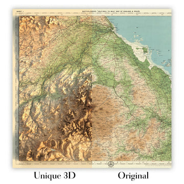
For something truly unique, this map is also available in "Unique 3D", our trademarked process that dramatically transforms the map so that it has a wonderful sense of depth. We combine the original map with detailed topography and elevation data, so that mountains and the terrain really "pop". For more info and examples of 3D maps, check my Unique 3D page.
Tauchen Sie ein in das maritime Erbe Kanadas zu Beginn des zwanzigsten Jahrhunderts mit "Maritime Provinces & Newfoundland", einem meisterhaften kartografischen Werk von 1922 des gefeierten John George Bartholomew. Diese exquisite Karte, die ursprünglich im angesehenen Times Atlas & Gazetteer of the World veröffentlicht wurde, markiert einen entscheidenden Übergang in der Kunst und Wissenschaft der Kartografie. Bartholomews Vision brachte eine neue Ära der Genauigkeit und Eleganz hervor, ersetzte die früheren Andree-Karten von 1895 und setzte einen neuen Standard für geographische Wissenschaft. Die detaillierte Darstellung der Maritimen Provinzen – Nova Scotia, New Brunswick, Prince Edward Island – und des damals unabhängigen Neufundlands fängt eine Region ein, die von Jahrhunderten der Seefahrt, des Handels und des kulturellen Austauschs geprägt ist.
Bartholomews Kunstfertigkeit wird sofort in der Verwendung von hypsometrischen Farbtönen deutlich, einer raffinierten Technik, die Farbverläufe nutzt, um die subtilen Erhebungen des Landes zu offenbaren. Die physische Geographie der Region wird lebendig, von den bewaldeten Cape Breton Highlands bis zu den sanften Hügeln und Flusstälern von New Brunswick. Bathymetrische Schattierungen bringen die umliegenden Meere scharf zur Geltung, wobei die dramatischen Tiefen der Bay of Fundy und des Golfs von St. Lawrence in fesselnden Details dargestellt werden. Die akribische Handkolorierung und elegante Typografie der Karte wecken das goldene Zeitalter der Atlasproduktion und machen sie sowohl zu einem Kunstwerk als auch zu einem Navigationswerkzeug.
Über ihre visuelle Anziehungskraft hinaus ist diese Karte ein Dokument eines transformierenden historischen Moments. Sie wurde erstellt, als Neufundland noch ein separates Dominion war, und präsentiert die politischen Grenzen und Landkreisaufteilungen einer Region, die am Vorabend des Wandels steht. Die markierten Schifffahrtsrouten, komplett mit präzisen Entfernungen, sprechen von der anhaltenden Bedeutung des maritimen Handels und den täglichen Rhythmen des Lebens, die vom Atlantik geprägt sind. Mit einem detaillierten Plan von Halifax – damals, wie heute, einer geschäftigen Hafenstadt – bietet die Karte sowohl einen grandiosen Überblick als auch eine fokussierte Studie eines der vitalsten städtischen Zentren der Region.
Die Oberfläche der Karte ist ein Wandteppich menschlicher Siedlungen und natürlicher Wunder. Von den geschichtsträchtigen Städten Halifax, Saint John und St. John’s bis zu den kleineren Städten, die die Küsten und Flussufer säumen, ist jede Gemeinde sorgfältig eingetragen und zeugt vom Wachstum und der Vielfalt der Maritimen Provinzen. Wichtige Flüsse wie der Saint John und Miramichi schneiden sich durch die Landschaft, während die komplexen Küstenlinien von Cape Breton Island, der Avalon-Halbinsel und Prince Edward Island mit der liebevollen Präzision eines Kartografen dargestellt sind. Bemerkenswerterweise spiegelt das Fehlen von Nationalparks oder historischen Wahrzeichen die zeitliche Fokussierung der Karte wider, doch das Land und das Meer selbst stehen als beständige Denkmäler des reichen natürlichen und kulturellen Erbes der Region.
John George Bartholomew, oft als „der Prinz der Kartografen“ bezeichnet, verlieh dieser Karte sowohl wissenschaftliche Strenge als auch künstlerische Anmut. Sein Pionierwerk in der thematischen und physischen Kartierung wird in vollem Umfang präsentiert und bietet einen Einblick in das sich entwickelnde Verständnis der östlichsten Provinzen Kanadas. Diese Karte ist nicht nur ein Dokument der Geographie – sie ist ein Zeugnis der intellektuellen Neugier, technischen Innovation und der zeitlosen Anziehungskraft der Erkundung in dieser Epoche. Für Sammler und Kenner ist "Maritime Provinces & Newfoundland" eine seltene Gelegenheit, ein Stück kartografischer Geschichte zu besitzen, das mit den Geschichten des Landes, des Meeres und der Menschen, die diese Region ihr Zuhause nennen, resoniert.
Städte und Gemeinden auf dieser Karte
- Nova Scotia
- Halifax
- Sydney
- Neues Glasgow
- Truro
- Amherst
- Kentville
- Yarmouth
- Bridgewater
- Antigonish
-
Windsor
-
New Brunswick
- Moncton
- Saint John
- Fredericton
- Bathurst
- Edmundston
- Campbellton
- Miramichi (dann Chatham/Newcastle)
- Sackville
-
Woodstock
-
Prince Edward Island
- Charlottetown
-
Summerside
-
Neufundland (jetzt Neufundland und Labrador)
- St. John’s
- Ecke Brook
- Grand Falls (jetzt Grand Falls-Windsor)
- Gander
Bemerkenswerte Merkmale & Wahrzeichen
- Provinzgrenzen für Nova Scotia, New Brunswick, Prince Edward Island und Neufundland
- Landkreisgrenzen innerhalb jeder Provinz, klar abgegrenzt
- Wichtige Flüsse, einschließlich des Saint John River und des Miramichi River
- Bucht von Fundy, bekannt für ihren signifikanten Tidenhub
- Golf von St. Lawrence, eine wichtige maritime Wasserstraße
- Cabot Strait, der Kanal zwischen Neufundland und Cape Breton Island
- Bathymetrische Schattierungen, die das Kontinentalregal und Unterwassermerkmale anzeigen
- Schifffahrtsrouten über den Nordatlantik, mit markierten Entfernungen
- Detaillierte Inset-Karte von Halifax und seinem Hafen
- Küstenmerkmale wie Cape Breton Island, die Landenge von Chignecto und die Avalon-Halbinsel
- Zahlreiche Inseln, einschließlich Prince Edward Island und der Magdalenen-Inseln
- Leuchttürme und Navigationshilfen entlang der Küsten markiert
- Höhenpunkte, die bemerkenswerte Erhebungen anzeigen, wie die Cape Breton Highlands
- Bewaldete und bergige Gebiete, die durch Farbschattierungen dargestellt werden
Historischer und gestalterischer Kontext
- Ursprünglicher Titel: Maritime Provinzen & Neufundland
- Erstellt von dem renommierten britischen Kartografen John George Bartholomew im Jahr 1922
- Veröffentlicht als Teil von "The Times Atlas & Gazetteer of the World," was einen bedeutenden Fortschritt in der kartografischen Technologie und Genauigkeit darstellt
- Erste Ausgabe des Times Atlas, die Bartholomews Karten verwendet, die frühere Andree-Karten von 1895 ersetzt
- Maßstab: 1:1.500.000, was eine detaillierte Erkundung und Referenz ermöglicht
- Verwendet hypsometrische Tönungen (Farbschattierungen) und Höhenpunkte zur Veranschaulichung der Geländehöhe
- Bathymetrische Tönungen zeigen Unterwassermerkmale und Meerestiefen
- Spiegelt die politischen Grenzen und Landkreisaufteilungen der Zeit wider, einschließlich Neufundland als separates Dominion (vor 1949)
- Betont sowohl politische Grenzen als auch physische Geographie
- Stellt die sich entwickelnde Natur des geografischen Wissens und der Präsentation im frühen 20. Jahrhundert dar
Bitte überprüfen Sie die Bilder, um sicherzustellen, dass eine bestimmte Stadt oder ein Ort auf dieser Karte angezeigt wird. Sie können sich auch gerne an uns wenden und uns bitten, die Karte für Sie zu überprüfen.
Diese Karte sieht in jeder Größe großartig aus, aber ich empfehle immer, eine größere Größe zu wählen, wenn Sie Platz haben. So können Sie alle Details leicht erkennen.
Diese Karte sieht bis zu 70 Zoll (180 cm) großartig aus. Wenn Sie nach einer größeren Karte suchen, bitte kontaktieren Sie uns.
Das Modell in den Listing-Bildern hält die 16x20 Zoll (40x50 cm) Version dieser Karte.
Das fünfte Listing-Bild zeigt ein Beispiel für meinen Personalisierungsservice für Karten.
Wenn Sie nach etwas anderem suchen, schauen Sie sich meine Sammlung der besten alten Karten an, um zu sehen, ob etwas anderes Ihr Interesse weckt.
Bitte kontaktieren Sie mich, um zu überprüfen, ob ein bestimmter Ort, ein Wahrzeichen oder ein Merkmal auf dieser Karte dargestellt ist.
Dies wäre ein wunderbares Geburtstags-, Weihnachts-, Vatertags-, Abschiedsgeschenk, Jubiläum oder Einweihungsgeschenk für jemanden aus den Gebieten, die von dieser Karte abgedeckt werden.
Diese Karte ist als Giclée-Druck auf säurefreiem, archiviertem, mattem Papier erhältlich, oder Sie können sie gerahmt kaufen. Der Rahmen ist ein schöner, einfacher schwarzer Rahmen, der zu den meisten Ästhetiken passt. Bitte kontaktieren Sie mich, wenn Sie eine andere Rahmenfarbe oder ein anderes Material wünschen. Meine Rahmen sind mit superklarem, museumsgrauem Acryl (Plexiglas/Acrylt) verglast, das deutlich weniger reflektierend ist als Glas, sicherer ist und immer in perfektem Zustand ankommt.
This map is also available as a float framed canvas, sometimes known as a shadow gap framed canvas or canvas floater. The map is printed on artist's cotton canvas and then stretched over a handmade box frame. We then "float" the canvas inside a wooden frame, which is available in a range of colours (black, dark brown, oak, antique gold and white). This is a wonderful way to present a map without glazing in front. See some examples of float framed canvas maps and explore the differences between my different finishes.
For something truly unique, this map is also available in "Unique 3D", our trademarked process that dramatically transforms the map so that it has a wonderful sense of depth. We combine the original map with detailed topography and elevation data, so that mountains and the terrain really "pop". For more info and examples of 3D maps, check my Unique 3D page.
Many of our maps and art prints are chosen as thoughtful gifts for homes, offices, studies and meaningful places.
Choose a framed option for the easiest ready-to-hang gift, or choose an unframed print if the recipient may prefer to select their own frame.
We make orders locally in 23 countries around the world, so gifts can often be produced close to the recipient. This helps them arrive faster, travel more safely, and avoid customs or import duty surprises.
- We can deliver directly to the recipient
- Framed pieces arrive ready to hang
- Unframed prints are carefully packed in a strong protective tube
- Almost every order is made locally, for faster, safer gifting
- 90-day returns give the recipient time to decide
If you are not sure what to choose, please contact us. We can help you pick the right map, size, finish or delivery option.
Für die meisten Bestellungen beträgt die Lieferzeit etwa 3 Werktage. Personalisierte und maßgeschneiderte Produkte benötigen länger, da ich die Personalisierung durchführen und sie Ihnen zur Genehmigung zusenden muss, was normalerweise 1 oder 2 Tage dauert.
Bitte beachten Sie, dass sehr große gerahmte Bestellungen in der Regel länger für die Herstellung und Lieferung benötigen.
Wenn Sie möchten, dass Ihre Bestellung bis zu einem bestimmten Datum ankommt, bitte kontaktieren Sie mich, bevor Sie bestellen, damit wir den besten Weg finden können, um sicherzustellen, dass Sie Ihre Bestellung rechtzeitig erhalten.
Ich drucke und rahme Karten und Kunstwerke in 23 Ländern weltweit. Das bedeutet, dass Ihre Bestellung lokal gefertigt wird, was die Lieferzeit verkürzt und sicherstellt, dass sie während der Lieferung nicht beschädigt wird. Sie zahlen nie Zoll oder Einfuhrgebühren, und wir stoßen weniger CO2 in die Luft aus.
Alle meine Karten und Kunstdrucke sind gut verpackt und werden in einem robusten Rohr versendet, wenn sie ungerahmt sind, oder von Schaum umgeben, wenn sie gerahmt sind.
Ich versuche, alle Bestellungen innerhalb von 1 oder 2 Tagen nach Erhalt Ihrer Bestellung zu versenden, obwohl einige Produkte (wie Gesichtsmasken, Tassen und Tragetaschen) länger zur Herstellung benötigen können.
Wenn Sie Express-Lieferung an der Kasse auswählen, priorisieren wir Ihre Bestellung und versenden sie per 1-Tages-Kurier (Fedex, DHL, UPS, Parcelforce).
Nächster Tag Lieferung ist auch in einigen Ländern verfügbar (USA, UK, Singapur, VAE), aber bitte versuchen Sie, früh am Tag zu bestellen, damit wir es rechtzeitig versenden können.
Lesen Sie meinen vollständigen Leitfaden zur Lieferung und lokalen Produktion
Mein Standardrahmen ist ein Galerie-Stil-Rahmen aus schwarzem Eschenholz. Er ist einfach und sieht ziemlich modern aus. Mein Standardrahmen ist etwa 20 mm (0,8 Zoll) breit.
Ich verwende super-klares Acryl (Plexiglas/Acrylt) für das Glas des Rahmens. Es ist leichter und sicherer als Glas – und es sieht besser aus, da die Reflexion geringer ist.
Sechs Standardrahmenfarben sind kostenlos erhältlich (schwarz, dunkelbraun, dunkelgrau, Eiche, weiß und antikgold).
Die meisten Karten, Kunstwerke und Illustrationen sind auch als gerahmte Leinwand erhältlich. Wir verwenden matte (nicht glänzende) Baumwollleinwand, spannen sie über einen nachhaltig beschafften Buchenrahmen und 'schweben' dann das Stück innerhalb eines Holzrahmens. Das Endergebnis ist ziemlich schön, und es gibt keine Verglasung, die im Weg ist.
Alle Rahmen werden "bereit zum Aufhängen" geliefert, entweder mit einer Schnur oder Halterungen auf der Rückseite. Sehr große Rahmen haben schwere Aufhängeplatten und/oder eine Montageschiene. Wenn Sie Fragen haben, können Sie bitte Kontakt aufnehmen.
Sehen Sie sich einige Beispiele meiner gerahmten Karten und gerahmten Leinwandkarten an.
Alternativ kann ich auch alte Karten und Kunstwerke auf Leinwand, Schaumstoffplatten, Baumwollrag und andere Materialien liefern.
Wenn Sie Ihre Karte oder Ihr Kunstwerk selbst rahmen möchten, lesen Sie bitte zuerst meinen Größenleitfaden.
Meine Karten sind äußerst hochwertige Reproduktionen von Originalkarten.
Ich beziehe originale, seltene Karten aus Bibliotheken, Auktionshäusern und Privatsammlungen auf der ganzen Welt, restauriere sie in meiner Londoner Werkstatt und erstelle dann mit speziellen Giclée-Tinten und -Druckern wunderschöne Karten, die sogar noch besser aussehen als das Original.
Meine Karten werden auf säurefreiem, mattem Archivpapier (nicht glänzend) gedruckt, das sich sehr hochwertig anfühlt und fast wie Karton aussieht. Technisch gesehen beträgt das Papiergewicht/die Papierdicke 10mil/200g/m². Es eignet sich perfekt zum Einrahmen.
Ich drucke mit UV-lichtbeständigen Ultrachrome-Giclée-Pigmenttinten von Epson – einige der besten Tinten, die Sie finden können.
Ich kann auch machen Karten auf Leinwand, Baumwolllappen und andere exotische Materialien.
Erfahren Sie mehr über The Unique Maps Co.
Kartenpersonalisierung
Wenn Sie nach dem perfekten Geschenk zum Jahrestag oder zur Einweihung suchen, kann ich Ihre Karte personalisieren, um sie wirklich einzigartig zu machen. Ich kann beispielsweise eine kurze Nachricht hinzufügen, einen wichtigen Ort hervorheben oder das Wappen Ihrer Familie hinzufügen.
Die Möglichkeiten sind nahezu unbegrenzt. Bitte sehen Sie sich meine Kartenpersonalisierungsseite für einige wunderbare Beispiele dessen, was möglich ist.
Um eine personalisierte Karte zu bestellen, wählen Sie „Personalisieren Sie Ihre Karte“, bevor Sie sie in den Warenkorb legen.
In Kontakt kommen wenn Sie nach komplexeren Anpassungen und Personalisierungen suchen.
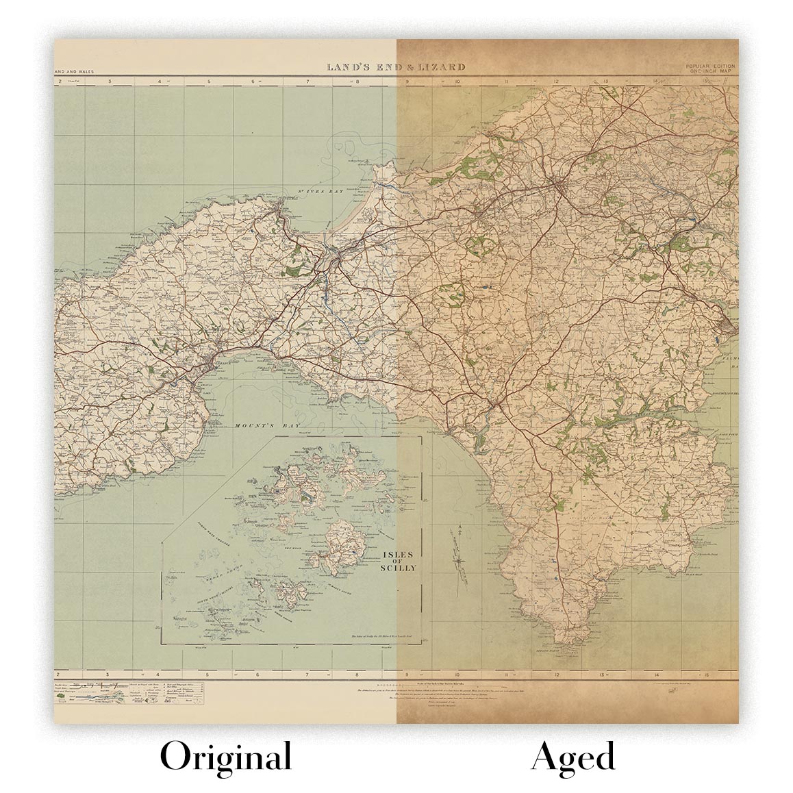
Kartenalterung
Im Laufe der Jahre wurde ich von Kunden hunderte Male gefragt, ob sie eine Karte kaufen könnten, die noch älter.
Nun, jetzt können Sie das, indem Sie „Alter“ auswählen, bevor Sie eine Karte in Ihren Warenkorb legen.
Alle Produktfotos, die Sie auf dieser Seite sehen, zeigen die Karte in ihrer Originalform. So sieht die Karte heute aus.
Wenn Sie „Gealtert“ auswählen, werde ich Ihre Karte von Hand altern lassen. Dazu verwende ich ein spezielles und einzigartiges Verfahren, das ich durch jahrelanges Studium alter Karten und Gespräche mit Forschern zum Verständnis der Chemie alternder Papiere entwickelt habe, und natürlich ... viel Übung!
Wenn Sie sich nicht sicher sind, bleiben Sie bei der Originalfarbe der Karte. Wenn Sie etwas Dunkleres und älter Wenn Sie auf der Suche sind, entscheiden Sie sich für „Aged“.
Sehen Sie einige erstaunliche Beispiele für gealterte Karten.
Wenn Sie aus irgendeinem Grund mit Ihrer Bestellung nicht zufrieden sind, kontaktieren Sie mich für eine unkomplizierte Rückerstattung. Bitte sehen Sie sich unsere Rückgabe- und Rückerstattungsrichtlinien für weitere Informationen an.
Ich bin sehr zuversichtlich, dass Ihnen Ihre restaurierte Karte oder Kunstdruck gefallen wird. Ich mache das seit 1984. Ich bin ein 5-Sterne Etsy-Verkäufer. Ich habe Zehntausende von Karten und Kunstdrucken verkauft und habe über 5.000 echte 5-Sterne-Bewertungen.
Ich verwende einen einzigartigen Prozess, um Karten und Kunstwerke zu restaurieren, der extrem zeitaufwendig und arbeitsintensiv ist. Die Suche nach den Originalkarten und Illustrationen kann Monate dauern. Ich benutze modernste und unglaublich teure Technologie, um sie zu scannen und wiederherzustellen. Daher garantiere ich, dass meine Karten und Kunstdrucke eine Klasse für sich sind - deshalb kann ich eine unkomplizierte Rückerstattung anbieten.
Fast alle meine Karten und Kunstdrucke sehen in großen Größen (200 cm, 6,5 Fuß+) erstaunlich aus und ich kann sie Ihnen auch gerahmt und über einen speziellen Übergrößen-Kurier liefern. Kontaktieren Sie mich, um Ihre speziellen Bedürfnisse zu besprechen.
Or try searching for something!


