

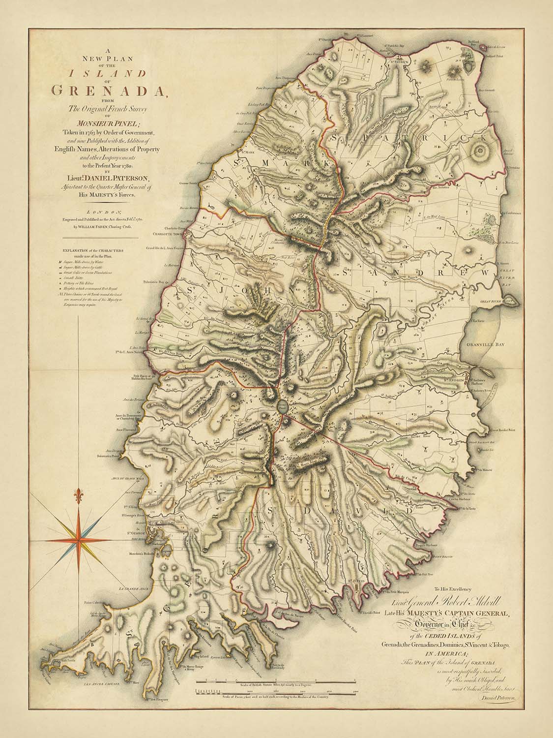


Seltene Karte von Grenada von Paterson, 1780: St. George's, Anwesen, Flüsse, Bedford Point, Plantagen
Kaufe 2, Erhalte 1 Kostenlos
Wenn Sie 2 Artikel in Ihren Warenkorb legen, können Sie ein drittes Produkt kostenlos hinzufügen.
Dies gilt für alle Karten und Kunstwerke, einschließlich individuell gestalteter und personalisierter Stücke. Sie können 3 von derselben Sache oder 3 verschiedene Dinge bestellen.
Das entspricht einem Rabatt von 33 %, der in diesem Jahr der größte Rabatt in meinem Shop sein wird.
Bitte nutzen Sie das Angebot und dekorieren Sie Ihre Wände mit schönen Karten und Kunst!
Kontaktieren Sie mich, wenn Sie Fragen haben.

-
![]() Handmade locally in the EU
Handmade locally in the EU
-
FREE worldwide delivery in 2-3 days ⓘ
Free delivery in 2-3 days
Your map should be delivered in 2-3 working days with free delivery, worldwide.
We make maps by hand locally in 23 countries, including the EU
![]() . If you're buying a gift for someone in another country, we will make the map locally to them.
. If you're buying a gift for someone in another country, we will make the map locally to them.You will never pay import tax or customs duty.
Express delivery is available at checkout which can reduce the delivery time to 1-2 days.
Please note that personalised maps, and larger framed maps, can take longer to produce and deliver.
If you need your order to arrive by a certain date, contact me and we can discuss your options.
-
90 day money back guarantee
ⓘ
90 Tage für Rückgabe und Rückerstattung
Produkte können innerhalb von 90 Tagen für eine vollständige Rückerstattung oder einen Umtausch gegen ein anderes Produkt zurückgegeben werden.
Für personalisierte oder maßgefertigte Artikel können wir Ihnen möglicherweise Guthaben im Geschäft oder eine nicht ablaufende Geschenkkarte anbieten, da wir personalisierte Bestellungen nicht wiederverkaufen können.
Wenn Sie Fragen haben, nehmen Sie Kontakt auf. Für weitere Informationen siehe unsere vollständige Rückgabe- und Umtauschrichtlinie.

My maps are rare, museum-grade, restored old maps sourced from libraries, auction houses and private collections across the globe.
Framing & free personalisation available
1. Select your size
2. Customise your map
Personalise your map with framing, hand-drawn customisation, vintage ageing, pop art text, unique 3D styling and moreGeschenkmitteilung & individuelle Ausführung

Wenn Sie eine Geschenkmitteilung oder eine Ausführung (Puzzle, Aluminiumplatte usw.) hinzufügen möchten, die hier nicht verfügbar ist, geben Sie dies bitte in der "Bestellnotiz" beim Checkout an.
Jede Bestellung wird individuell angefertigt. Wenn Sie die Größe leicht anpassen oder auf einem ungewöhnlichen Material drucken lassen möchten, lassen Sie es uns einfach wissen. Wir haben im Laufe der Jahre Tausende von individuellen Bestellungen bearbeitet, daher gibt es (fast) nichts, was wir nicht bewältigen können.
Sie können uns auch kontaktieren, bevor Sie bestellen, wenn Sie möchten!

- Handmade locally. No import duty or tax
- FREE Delivery. Arrives in 2-3 days
- Love it or your money back
- Questions? WhatsApp me any time
Own a piece of history
5,000+ 5 star reviews


Tauchen Sie ein in die komplexe Schönheit und historische Schwere von Daniel Patersons „A New Plan of the Island of Grenada, From The Original French Survey of Monsieur Pinel; Taken in 1763 by Order of the Government, and now Published with the Addition of English Names, Alterations of Property and other Improvements to the Present Year 1780.“ Dieses außergewöhnliche kartografische Werk erfasst die Insel Grenada in einem entscheidenden Moment ihrer Kolonialgeschichte, als die britische Verwaltung versuchte, ihr neuestes karibisches Besitz mit beispielloser Präzision zu dokumentieren und zu verwalten. Die detaillierte Darstellung der Topografie Grenadas, der Grundstücksaufteilungen und der wirtschaftlichen Unternehmen bietet einen faszinierenden Einblick in die Welt der Zucker-, Kaffee- und Kakaoplantagen des späten 18. Jahrhunderts, wobei jedes Grundstück sorgfältig nummeriert und symbolisiert ist.
Daniel Paterson, der angesehene britische Offizier und Kartograf, war bekannt für seine akribische Detailgenauigkeit und sein Engagement für die Kunst der militärischen und administrativen Kartografie. Patersons Karriere, die Dienst als Assistent des Quartermaster-General und später als Lieutenant Governor von Quebec umfasste, verlieh ihm eine einzigartige Perspektive auf die strategischen und wirtschaftlichen Imperative des britischen Empires. Seine Karten, die für ihre Genauigkeit und Klarheit geschätzt wurden, waren wesentliche Werkzeuge sowohl für die Regierungsführung als auch für den Handel, und dieser Plan von Grenada steht als Zeugnis für sein Können und seine Vision.
Die Karte ist nicht nur ein Dokument des Grundeigentums, sondern auch eine Schau der lebendigen Landschaft Grenadas. Vom geschäftigen Hauptstadt St. George's bis zu den fruchtbaren Tälern und dem schattierten Relief des bergigen Inneren der Insel wird jedes Merkmal mit Sorgfalt dargestellt. Flüsse und Bäche schlängeln sich durch das Terrain, während die Küste von Befestigungen wie dem bemerkenswerten Bedford Point Batterie durchzogen ist, eine Erinnerung an die strategische Bedeutung der Insel in der Karibik. Die Grenzen jedes Anwesens sind scharf umrissen und spiegeln die sozialen und wirtschaftlichen Hierarchien der damaligen Zeit wider.
Ein bemerkenswertes Merkmal von Patersons Werk ist der umfassende Schlüssel, der den Betrachter durch das wirtschaftliche Leben der Insel führt. Symbole unterscheiden zwischen Zuckermühlen, die von Wasser oder Vieh betrieben werden, umfangreichen und bescheidenen Kaffee- oder Kakaoplantagen und sogar Töpfer- oder Ziegelfabriken. Diese Aufmerksamkeit für die Vielfalt der Industrien Grenadas bietet einen unvergleichlichen Einblick in koloniales Unternehmertum und Ambitionen und beleuchtet die Wege, auf denen natürliche Ressourcen und menschliche Einfallsreichtum das Schicksal der Insel prägten.
Dem Lieutenant General Robert Melvill, dem damaligen Gouverneur von Grenada, den Grenadinen, St. Vincent und Tobago, gewidmet, ist diese Karte durchdrungen von der Autorität und den Bestrebungen des britischen Kolonialprojekts. Ihre Seltenheit – nur in drei Zuständen bekannt und selten auf dem Markt anzutreffen – erhöht ihren Reiz für Sammler und Historiker gleichermaßen. Als sowohl Kunstwerk als auch Dokument des Imperiums bietet Patersons Karte von Grenada ein reiches, multidimensionales Porträt einer Insel an der Kreuzung von Geschichte, Handel und kartografischer Exzellenz.
Städte und Gemeinden auf dieser Karte
- St. George's (größte Stadt, heutige Hauptstadt)
- Grenville
- Gouyave
- Victoria
- Sauteurs
- Calivigny
- Charlotte Town (historische Siedlung, heute kleinere Bevölkerung)
Bemerkenswerte Merkmale & Wahrzeichen
- Befestigungen am Bedford Point (mit 6 Kanonen vermerkt)
- Batterie östlich von St. Patrick
- Karibisches Meer (umgibt die Insel)
- Deutlich gekennzeichnete Flüsse und Bäche auf der gesamten Insel
- Schattierte Reliefdarstellung, die bergiges Gelände und Höhenlagen anzeigt
- Deutlich abgesteckte und nummerierte Grundstücksgrenzen, die den einzelnen Landbesitz entsprechen
- Symbole, die Zuckermühlen (betrieben mit Wasser oder Vieh) anzeigen
- Symbole, die große und kleine Kaffee- oder Kakaoplantagen anzeigen
- Symbole, die Töpferei- oder Ziegelfabriken anzeigen
Historischer und gestalterischer Kontext
- Erstellt im Jahr 1780 von Daniel Paterson, einem Offizier der britischen Armee und renommierten Kartografen
- Veröffentlicht von William Faden, einem führenden Kartografen mit Sitz in London
- Basierend auf der ursprünglichen französischen Vermessung durch Monsieur Pinel, die 1763 durchgeführt wurde
- Widmet sich Lieutenant General Robert Melvill, Gouverneur von Grenada, den Grenadinen, St. Vincent & Tobago
- Produziert während der britischen Kolonialzeit, kurz nachdem Grenada britisches Territorium wurde
- Hochdetailliert, mit nummerierten Flächen, die den einzelnen Landbesitz entsprechen
- Enthält einen umfassenden Schlüssel zu wirtschaftlichen Merkmalen und Landnutzung
- In drei seltenen Zuständen bekannt: Ausgaben von 1780, 1796 und 1825
Bitte überprüfen Sie die Bilder, um sicherzustellen, dass eine bestimmte Stadt oder ein bestimmter Ort auf dieser Karte dargestellt ist. Sie können uns auch kontaktieren und fragen, ob wir die Karte für Sie überprüfen können.
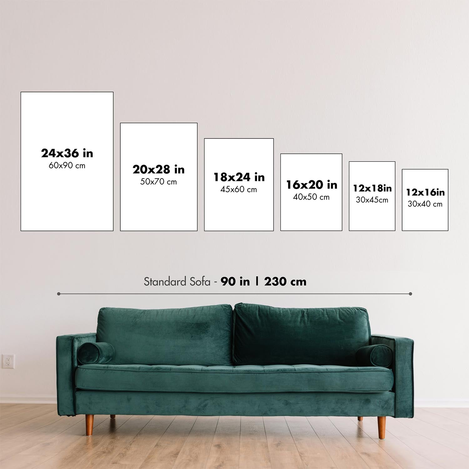
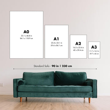
Diese Karte sieht in jeder Größe großartig aus, aber ich empfehle immer, eine größere Größe zu wählen, wenn Sie Platz haben. So können Sie alle Details leicht erkennen.
Diese Karte sieht bis zu 100 Zoll (250 cm) fantastisch aus. Wenn Sie nach einer größeren Karte suchen, bitte kontaktieren Sie uns.
Das Modell in den Angebotsbildern hält die 18x24 Zoll (45x60 cm) Version dieser Karte.
Das fünfte Angebotsbild zeigt ein Beispiel meines Personalisierungsdienstes für Karten.
Wenn Sie nach etwas etwas anderem suchen, schauen Sie sich meine Sammlung der besten alten Karten an, um zu sehen, ob etwas anderes Ihr Interesse weckt.
Bitte kontaktieren Sie mich, um zu überprüfen, ob ein bestimmter Standort, Wahrzeichen oder Merkmal auf dieser Karte dargestellt ist.
Dies wäre ein wunderbares Geschenk zum Geburtstag, zu Weihnachten, zum Vatertag, zum Abschied von der Arbeit, zum Jubiläum oder zur Einweihung für jemanden aus den von dieser Karte abgedeckten Gebieten.
Diese Karte ist als Giclée-Druck auf säurefreiem, archivierbarem mattem Papier erhältlich, oder Sie können sie gerahmt kaufen. Der Rahmen ist ein schöner, einfacher schwarzer Rahmen, der zu den meisten Ästhetiken passt. Bitte kontaktieren Sie mich, wenn Sie eine andere Rahmenfarbe oder -material wünschen. Meine Rahmen sind mit superklarem museumsglassem Acryl (Plexiglas/Acrylt) verglast, das deutlich weniger reflektierend ist als Glas, sicherer und immer in perfektem Zustand ankommt.
This map is also available as a float framed canvas, sometimes known as a shadow gap framed canvas or canvas floater. The map is printed on artist's cotton canvas and then stretched over a handmade box frame. We then "float" the canvas inside a wooden frame, which is available in a range of colours (black, dark brown, oak, antique gold and white). This is a wonderful way to present a map without glazing in front. See some examples of float framed canvas maps and explore the differences between my different finishes.
For something truly unique, this map is also available in "Unique 3D", our trademarked process that dramatically transforms the map so that it has a wonderful sense of depth. We combine the original map with detailed topography and elevation data, so that mountains and the terrain really "pop". For more info and examples of 3D maps, check my Unique 3D page.
Für die meisten Bestellungen beträgt die Lieferzeit etwa 3 Werktage. Personalisierte und maßgeschneiderte Produkte benötigen länger, da ich die Personalisierung durchführen und sie Ihnen zur Genehmigung zusenden muss, was normalerweise 1 oder 2 Tage dauert.
Bitte beachten Sie, dass sehr große gerahmte Bestellungen in der Regel länger für die Herstellung und Lieferung benötigen.
Wenn Sie möchten, dass Ihre Bestellung bis zu einem bestimmten Datum ankommt, bitte kontaktieren Sie mich, bevor Sie bestellen, damit wir den besten Weg finden können, um sicherzustellen, dass Sie Ihre Bestellung rechtzeitig erhalten.
Ich drucke und rahme Karten und Kunstwerke in 23 Ländern weltweit. Das bedeutet, dass Ihre Bestellung lokal gefertigt wird, was die Lieferzeit verkürzt und sicherstellt, dass sie während der Lieferung nicht beschädigt wird. Sie zahlen nie Zoll oder Einfuhrgebühren, und wir stoßen weniger CO2 in die Luft aus.
Alle meine Karten und Kunstdrucke sind gut verpackt und werden in einem robusten Rohr versendet, wenn sie ungerahmt sind, oder von Schaum umgeben, wenn sie gerahmt sind.
Ich versuche, alle Bestellungen innerhalb von 1 oder 2 Tagen nach Erhalt Ihrer Bestellung zu versenden, obwohl einige Produkte (wie Gesichtsmasken, Tassen und Tragetaschen) länger zur Herstellung benötigen können.
Wenn Sie Express-Lieferung an der Kasse auswählen, priorisieren wir Ihre Bestellung und versenden sie per 1-Tages-Kurier (Fedex, DHL, UPS, Parcelforce).
Nächster Tag Lieferung ist auch in einigen Ländern verfügbar (USA, UK, Singapur, VAE), aber bitte versuchen Sie, früh am Tag zu bestellen, damit wir es rechtzeitig versenden können.
Lesen Sie meinen vollständigen Leitfaden zur Lieferung und lokalen Produktion
Mein Standardrahmen ist ein Galerie-Stil-Rahmen aus schwarzem Eschenholz. Er ist einfach und sieht ziemlich modern aus. Mein Standardrahmen ist etwa 20 mm (0,8 Zoll) breit.
Ich verwende super-klares Acryl (Plexiglas/Acrylt) für das Glas des Rahmens. Es ist leichter und sicherer als Glas – und es sieht besser aus, da die Reflexion geringer ist.
Sechs Standardrahmenfarben sind kostenlos erhältlich (schwarz, dunkelbraun, dunkelgrau, Eiche, weiß und antikgold).
Die meisten Karten, Kunstwerke und Illustrationen sind auch als gerahmte Leinwand erhältlich. Wir verwenden matte (nicht glänzende) Baumwollleinwand, spannen sie über einen nachhaltig beschafften Buchenrahmen und 'schweben' dann das Stück innerhalb eines Holzrahmens. Das Endergebnis ist ziemlich schön, und es gibt keine Verglasung, die im Weg ist.
Alle Rahmen werden "bereit zum Aufhängen" geliefert, entweder mit einer Schnur oder Halterungen auf der Rückseite. Sehr große Rahmen haben schwere Aufhängeplatten und/oder eine Montageschiene. Wenn Sie Fragen haben, können Sie bitte Kontakt aufnehmen.
Sehen Sie sich einige Beispiele meiner gerahmten Karten und gerahmten Leinwandkarten an.
Alternativ kann ich auch alte Karten und Kunstwerke auf Leinwand, Schaumstoffplatten, Baumwollrag und andere Materialien liefern.
Wenn Sie Ihre Karte oder Ihr Kunstwerk selbst rahmen möchten, lesen Sie bitte zuerst meinen Größenleitfaden.
Einige meiner alten Karten sind jetzt als gerahmte Leinwände erhältlich. Bitte kontaktiere mich, wenn du eine Größe bestellen möchtest, die in meinem Shop nicht verfügbar ist.
Leinwand alte Karten sind eine interessante Alternative zu konventionell gerahmten Karten. Je nach deinem persönlichen Geschmack und der Raumdekoration können Leinwandkarten etwas mehr „herausstechen“ als eine gerahmte Karte.
Meine Karten sind äußerst hochwertige Reproduktionen von Originalkarten.
Ich beziehe originale, seltene Karten aus Bibliotheken, Auktionshäusern und Privatsammlungen auf der ganzen Welt, restauriere sie in meiner Londoner Werkstatt und erstelle dann mit speziellen Giclée-Tinten und -Druckern wunderschöne Karten, die sogar noch besser aussehen als das Original.
Meine Karten werden auf säurefreiem, mattem Archivpapier (nicht glänzend) gedruckt, das sich sehr hochwertig anfühlt und fast wie Karton aussieht. Technisch gesehen beträgt das Papiergewicht/die Papierdicke 10mil/200g/m². Es eignet sich perfekt zum Einrahmen.
Ich drucke mit UV-lichtbeständigen Ultrachrome-Giclée-Pigmenttinten von Epson – einige der besten Tinten, die Sie finden können.
Ich kann auch machen Karten auf Leinwand, Baumwolllappen und andere exotische Materialien.
Erfahren Sie mehr über The Unique Maps Co.
Kartenpersonalisierung
Wenn Sie nach dem perfekten Geschenk zum Jahrestag oder zur Einweihung suchen, kann ich Ihre Karte personalisieren, um sie wirklich einzigartig zu machen. Ich kann beispielsweise eine kurze Nachricht hinzufügen, einen wichtigen Ort hervorheben oder das Wappen Ihrer Familie hinzufügen.
Die Möglichkeiten sind nahezu unbegrenzt. Bitte sehen Sie sich meine Kartenpersonalisierungsseite für einige wunderbare Beispiele dessen, was möglich ist.
Um eine personalisierte Karte zu bestellen, wählen Sie „Personalisieren Sie Ihre Karte“, bevor Sie sie in den Warenkorb legen.
In Kontakt kommen wenn Sie nach komplexeren Anpassungen und Personalisierungen suchen.
Kartenalterung
Im Laufe der Jahre wurde ich von Kunden hunderte Male gefragt, ob sie eine Karte kaufen könnten, die noch älter.
Nun, jetzt können Sie das, indem Sie „Alter“ auswählen, bevor Sie eine Karte in Ihren Warenkorb legen.
Alle Produktfotos, die Sie auf dieser Seite sehen, zeigen die Karte in ihrer Originalform. So sieht die Karte heute aus.
Wenn Sie „Gealtert“ auswählen, werde ich Ihre Karte von Hand altern lassen. Dazu verwende ich ein spezielles und einzigartiges Verfahren, das ich durch jahrelanges Studium alter Karten und Gespräche mit Forschern zum Verständnis der Chemie alternder Papiere entwickelt habe, und natürlich ... viel Übung!
Wenn Sie sich nicht sicher sind, bleiben Sie bei der Originalfarbe der Karte. Wenn Sie etwas Dunkleres und älter Wenn Sie auf der Suche sind, entscheiden Sie sich für „Aged“.
Sehen Sie einige erstaunliche Beispiele für gealterte Karten.
Wenn Sie aus irgendeinem Grund mit Ihrer Bestellung nicht zufrieden sind, kontaktieren Sie mich für eine unkomplizierte Rückerstattung. Bitte sehen Sie sich unsere Rückgabe- und Rückerstattungsrichtlinien für weitere Informationen an.
Ich bin sehr zuversichtlich, dass Ihnen Ihre restaurierte Karte oder Kunstdruck gefallen wird. Ich mache das seit 1984. Ich bin ein 5-Sterne Etsy-Verkäufer. Ich habe Zehntausende von Karten und Kunstdrucken verkauft und habe über 5.000 echte 5-Sterne-Bewertungen.
Ich verwende einen einzigartigen Prozess, um Karten und Kunstwerke zu restaurieren, der extrem zeitaufwendig und arbeitsintensiv ist. Die Suche nach den Originalkarten und Illustrationen kann Monate dauern. Ich benutze modernste und unglaublich teure Technologie, um sie zu scannen und wiederherzustellen. Daher garantiere ich, dass meine Karten und Kunstdrucke eine Klasse für sich sind - deshalb kann ich eine unkomplizierte Rückerstattung anbieten.
Fast alle meine Karten und Kunstdrucke sehen in großen Größen (200 cm, 6,5 Fuß+) erstaunlich aus und ich kann sie Ihnen auch gerahmt und über einen speziellen Übergrößen-Kurier liefern. Kontaktieren Sie mich, um Ihre speziellen Bedürfnisse zu besprechen.
Or try searching for something!


