


Alte Karte von Europa von John Tallis, 1851: Robbenjagd, Kamele, Sklavenmarkt usw.
Kaufe 2, Erhalte 1 Kostenlos
Wenn Sie 2 Artikel in Ihren Warenkorb legen, können Sie ein drittes Produkt kostenlos hinzufügen.
Dies gilt für alle Karten und Kunstwerke, einschließlich individuell gestalteter und personalisierter Stücke. Sie können 3 von derselben Sache oder 3 verschiedene Dinge bestellen.
Das entspricht einem Rabatt von 33 %, der in diesem Jahr der größte Rabatt in meinem Shop sein wird.
Bitte nutzen Sie das Angebot und dekorieren Sie Ihre Wände mit schönen Karten und Kunst!
Kontaktieren Sie mich, wenn Sie Fragen haben.

-
![]() Handmade locally in the EU
Handmade locally in the EU
-
FREE worldwide delivery in 2-3 days ⓘ
Free delivery in 2-3 days
Your map should be delivered in 2-3 working days with free delivery, worldwide.
Deliveries over the Christmas and New Year period may be slightly delayed, as couriers and postal services catch up with a huge backlog of packages.
We make maps by hand locally in 23 countries, including the EU
![]() . If you're buying a gift for someone in another country, we will make the map locally to them.
. If you're buying a gift for someone in another country, we will make the map locally to them.You will never pay import tax or customs duty.
Express delivery is available at checkout which can reduce the delivery time to 1-2 days.
Please note that personalised maps, and larger framed maps, can take longer to produce and deliver.
If you need your order to arrive by a certain date, contact me and we can discuss your options.
-
FREE gift preview
ⓘ
Digital gift preview
After you complete your order, you can send a beautiful digital preview to the gift recipient. Just provide their email address and we'll do the rest. (Their email address will not be stored or used for any other purpose.)
This is perfect if you're concerned that your order might not arrive in time.
You can also buy a real non-expiring gift card, and email it directly to the recipient, so they can buy their own map or artwork.
-
90 day money back guarantee
ⓘ
90 Tage für Rückgabe und Rückerstattung
Produkte können innerhalb von 90 Tagen für eine vollständige Rückerstattung oder einen Umtausch gegen ein anderes Produkt zurückgegeben werden.
Für personalisierte und maßgefertigte Artikel können wir Ihnen möglicherweise einen Gutschein oder eine nicht ablaufende Geschenkkarte anbieten, da wir personalisierte Bestellungen nicht weiterverkaufen können.
Wenn Sie Fragen haben, kontaktieren Sie uns. Für weitere Informationen siehe unsere vollständige Rückgabe- und Umtauschrichtlinie.

My maps are rare, museum-grade, restored old maps sourced from libraries, auction houses and private collections across the globe.
Framing & free personalisation available
1. Select your size
Click here to order a custom size.
2. Frame & personalise your map
Make your map unique with framing, hand-drawn customisation, vintage ageing, pop art text, unique 3D styling and more.


Geschenkmitteilung & individuelle Ausführung

Wenn Sie eine Geschenkmitteilung oder eine Ausführung (Puzzle, Aluminiumplatte usw.) hinzufügen möchten, die hier nicht verfügbar ist, geben Sie dies bitte in der "Bestellnotiz" beim Checkout an.
Jede Bestellung wird individuell angefertigt. Wenn Sie die Größe leicht anpassen oder auf einem ungewöhnlichen Material drucken lassen möchten, lassen Sie es uns einfach wissen. Wir haben im Laufe der Jahre Tausende von individuellen Bestellungen bearbeitet, daher gibt es (fast) nichts, was wir nicht bewältigen können.
Sie können uns auch kontaktieren, bevor Sie bestellen, wenn Sie möchten!

- Handmade locally. No import duty or tax
- FREE worldwide delivery
- Love it or your money back (90 days)
- Questions? WhatsApp me any time
Own a piece of history
5,000+ 5 star reviews


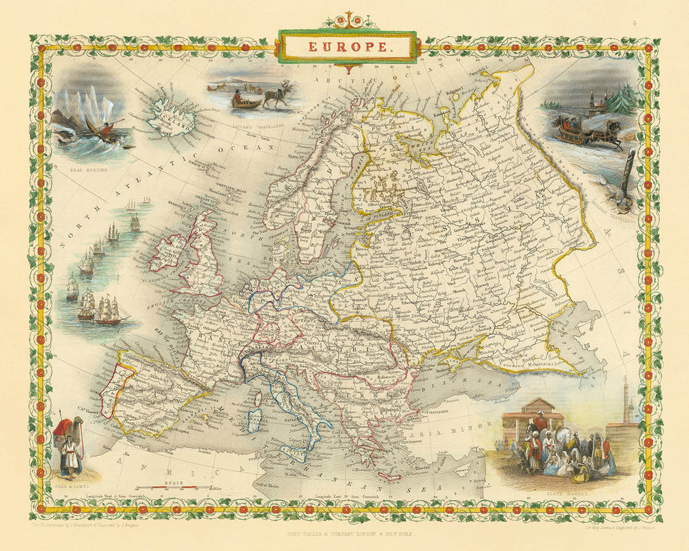
Betreten Sie das reiche Geflecht des neunzehnten Jahrhunderts in Europa mit „Europa“, der originalen Karte von 1851, meisterhaft gestaltet von John Tallis. Unter ihrem historischen Titel ist diese Karte mehr als ein geografisches Dokument – sie ist ein lebendiges Fenster zu einem Kontinent am Vorabend der Transformation. Beauftragt für R. Montgomery Martins gefeierten Illustrated Atlas, fasst Tallis' Werk die politische und physische Landschaft Europas zu einem entscheidenden Zeitpunkt zusammen, als Imperien über Grenzen hinweg reichten und die Aufmerksamkeit der Welt auf Erkundung, Handel und kulturellen Austausch gerichtet war.
John Tallis gehört zu den letzten großen dekorativen Kartenmachern, bekannt für seine exquisite Detailgenauigkeit und seine Fähigkeit, Kunstfertigkeit in die Kartographie zu verweben. Seine Karten sind sowohl bei Sammlern als auch bei Historikern geschätzt, nicht nur wegen ihrer Genauigkeit, sondern auch wegen ihrer Schönheit. Diese spezielle Karte zeigt Tallis' charakteristischen Stil: eine fein gravierte, farbenfrohe Komposition, umrahmt von einem kunstvollen dekorativen Rahmen, der die Betrachter einlädt, sowohl über die Geographie als auch über die Kunstfertigkeit nachzudenken. Die akribische Darstellung von Gebirgen, Flüssen und Küstenlinien spiegelt die hohen Standards der Kartenherstellung im viktorianischen Zeitalter wider.
Was diese Karte besonders macht, sind die eindrucksvollen Vignetten, die das zentrale Bild umgeben. Szenen wie der „Sklavenmarkt“, „Robbenjagd“, „Lapplandreisende“ und „Araber und Kamele“ bieten einen Einblick in die wirtschaftlichen, kulturellen und ethnografischen Realitäten der Zeit. Diese Illustrationen sind keine bloßen Verzierungen; sie sind historische Dokumente für sich, die die Faszination – und manchmal die Vorurteile – des neunzehnten Jahrhunderts in Europa gegenüber fernen Ländern und Völkern festhalten. Die Vignetten verwandeln die Karte in eine Erzählung, die Geschichten von Handel, Reisen und Begegnungen erzählt.
Der Inhalt der Karte ist ebenso umfassend wie schön. Wichtige Flüsse wie die Donau und der Rhein, imposante Gebirgszüge wie die Alpen und Karpaten sowie bedeutende Gewässer, darunter das Mittelmeer und die Ostsee, sind klar abgegrenzt. Wichtige Städte – London, Paris, Wien, Moskau und mehr – verankern die Karte, während Inseln wie Island und Sizilien mit sorgfältiger Präzision dargestellt sind. Die politischen Grenzen der Epoche sind treu wiedergegeben, mit dem Flickenteppich der deutschen Staaten, dem Einfluss der russischen und osmanischen Imperien und dem neu unabhängigen Griechenland, die alle ein Schnappschuss der komplexen und sich ständig verändernden Grenzen Europas bieten.
Historisch gesehen steht diese Karte als Zeugnis einer Zeit intensiver Neugier und Expansion. Sie spiegelt nicht nur die physische Geographie Europas wider, sondern auch die intellektuellen Strömungen ihrer Zeit: den Drang zu erkunden, zu dokumentieren und die Welt in all ihrer Vielfalt zu verstehen. Für den anspruchsvollen Sammler ist „Europa“ von John Tallis mehr als eine Karte – es ist ein Stück Geschichte, ein Kunstwerk und eine seltene Gelegenheit, eine greifbare Verbindung zur geschichtsträchtigen Vergangenheit des Kontinents zu besitzen.
Länder und Regionen auf dieser Karte
- Großbritannien (England, Schottland, Wales)
- Irland
- Frankreich
- Spanien
- Portugal
- Italien (einschließlich separater Bezeichnungen für Regionen wie Sardinien, Sizilien und Korsika)
- Schweiz
- Belgien
- Niederlande
- Deutsche Staaten (einschließlich Preußen, Bayern, Sachsen, Hannover usw.)
- Österreich (Österreichisches Kaiserreich)
- Ungarn
- Polen (als Teil anderer Imperien oder Territorien)
- Russland
- Dänemark
- Schweden und Norwegen (zu dieser Zeit vereint)
- Finnland (Teil des Russischen Reiches zu dieser Zeit)
- Osmanisches Reich (einschließlich Regionen in Südosteuropa)
- Griechenland
- Balkanregionen (wie Serbien, Bosnien, Walachei, Moldau)
- Lappland (Nördliches Skandinavien)
- Island
Bemerkenswerte Merkmale & Wahrzeichen
- Dekorativer Rand mit kunstvollen Kunstwerken und Farben
- Vignette mit dem Titel "Sklavenmarkt", die den historischen Sklavenhandel darstellt
- Vignette mit dem Titel "Robbenjagd", die wirtschaftliche Aktivitäten im Zusammenhang mit Jagd und Handel illustriert
- Vignette mit dem Titel "Lapplandreisende", die indigene Völker und ihre Reisemethoden zeigt
- Vignette mit dem Titel "Araber und Kamele", die kulturelle und Handelsinteraktionen darstellt
- Deutlich beschriftete große Gewässer, einschließlich des Atlantischen Ozeans, des Mittelmeers, der Nordsee, der Ostsee und des Schwarzen Meeres
- Bergketten klar dargestellt, einschließlich der Alpen, Pyrenäen und Karpaten
- Wichtige Flüsse wie die Donau, den Rhein und die Wolga sind deutlich beschriftet und sichtbar
- Wichtige Städte klar beschriftet, einschließlich London, Paris, Wien, Berlin, Madrid, Rom und Moskau
- Inseln wie Island, Korsika, Sardinien, Sizilien und die Britischen Inseln sind klar dargestellt und beschriftet
Historischer und gestalterischer Kontext
- Erstellt 1851 von John Tallis, einem der letzten großen dekorativen Kartenmacher
- Graviert für R. Montgomery Martins Illustrierten Atlas
- Bemerkenswert für seinen schönen, vollfarbigen dekorativen Stil und detaillierte Vignetten, die Szenen wie einen Sklavenmarkt, Robbenjagd, Lapplandreisende und Araber mit Kamelen illustrieren
- Dekorativ und detailliert, gekennzeichnet durch aufwändige Ränder und künstlerische Vignetten, die kulturelle und indigene Szenen darstellen
- Spiegelt die europäische Geographie des mittleren 19. Jahrhunderts, koloniale Interessen, ethnographische Neugier und wirtschaftliche Aktivitäten wider
- Die Vignetten geben Einblick in die europäischen Wahrnehmungen und Interessen an Ethnographie und Handel im mittleren 19. Jahrhundert
Bitte überprüfen Sie die Bilder, um sicherzustellen, dass eine bestimmte Stadt oder ein bestimmter Ort auf dieser Karte angezeigt wird. Sie können uns auch kontaktieren und fragen, ob wir die Karte für Sie überprüfen können.
Diese Karte sieht in jeder Größe großartig aus, aber ich empfehle immer, eine größere Größe zu wählen, wenn Sie Platz haben. So können Sie alle Details leicht erkennen.
Diese Karte sieht in Größen bis zu 50 Zoll (125 cm) fantastisch aus. Wenn Sie nach einer größeren Karte suchen, nehmen Sie bitte Kontakt auf.
Das Modell in den Angebotsbildern hält die 16x20 Zoll (40x50 cm) Version dieser Karte.
Das fünfte Angebotsbild zeigt ein Beispiel für meinen Personalisierungsservice für Karten.
Wenn Sie nach etwas leicht anderem suchen, schauen Sie sich meine Sammlung der besten alten Karten an, um zu sehen, ob Ihnen etwas anderes ins Auge fällt.
Bitte kontaktieren Sie mich, um zu überprüfen, ob ein bestimmter Standort, Wahrzeichen oder Merkmal auf dieser Karte angezeigt wird.
Dies wäre ein wunderbares Geburtstags-, Weihnachts-, Vatertags-, Abschieds-, Jubiläums- oder Einweihungsgeschenk für jemanden aus den in dieser Karte abgedeckten Regionen.
Diese Karte ist als Giclée-Druck auf säurefreiem, archivierbarem mattem Papier erhältlich, oder Sie können sie gerahmt kaufen. Der Rahmen ist ein schöner, schlichter schwarzer Rahmen, der zu den meisten Ästhetiken passt. Bitte nehmen Sie Kontakt auf, wenn Sie eine andere Rahmenfarbe oder -material wünschen. Meine Rahmen sind mit superklarem museumsgüte Acryl (Plexiglas/Acrylit) verglast, das deutlich weniger reflektierend ist als Glas, sicherer und immer in perfektem Zustand ankommt.
This map is also available as a float framed canvas, sometimes known as a shadow gap framed canvas or canvas floater. The map is printed on artist's cotton canvas and then stretched over a handmade box frame. We then "float" the canvas inside a wooden frame, which is available in a range of colours (black, dark brown, oak, antique gold and white). This is a wonderful way to present a map without glazing in front. See some examples of float framed canvas maps and explore the differences between my different finishes.
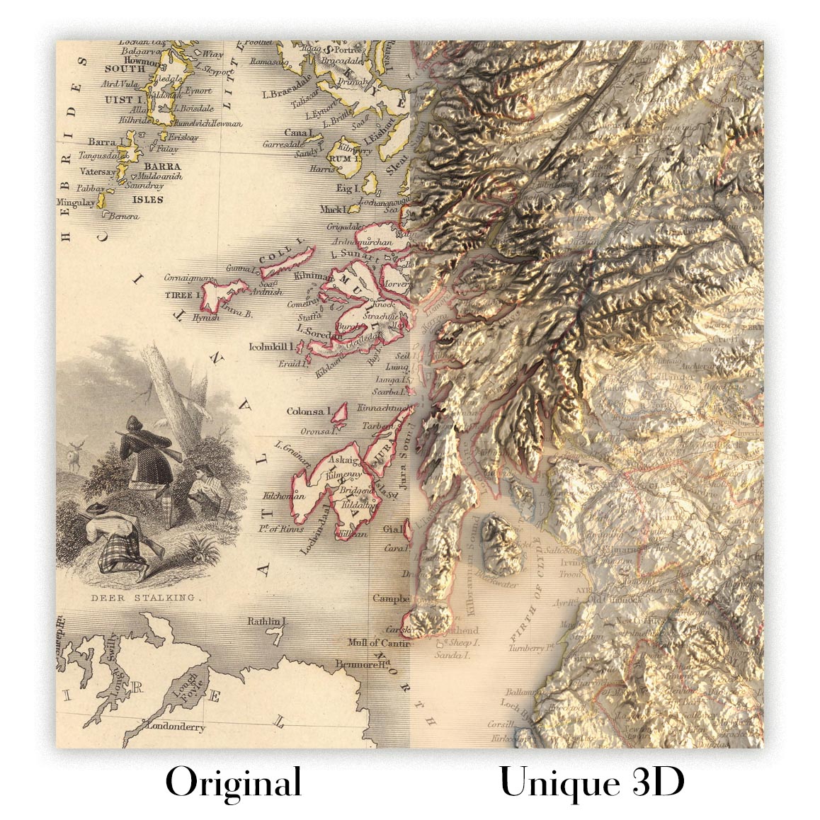
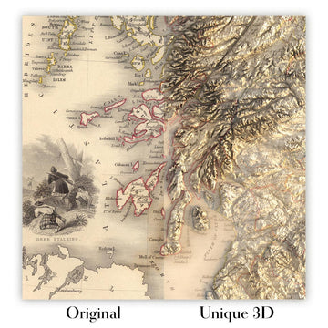
For something truly unique, this map is also available in "Unique 3D", our trademarked process that dramatically transforms the map so that it has a wonderful sense of depth. We combine the original map with detailed topography and elevation data, so that mountains and the terrain really "pop". For more info and examples of 3D maps, check my Unique 3D page.
Für die meisten Bestellungen beträgt die Lieferzeit etwa 3 Werktage. Personalisierte und maßgeschneiderte Produkte benötigen länger, da ich die Personalisierung durchführen und sie Ihnen zur Genehmigung zusenden muss, was normalerweise 1 oder 2 Tage dauert.
Bitte beachten Sie, dass sehr große gerahmte Bestellungen in der Regel länger für die Herstellung und Lieferung benötigen.
Wenn Sie möchten, dass Ihre Bestellung bis zu einem bestimmten Datum ankommt, bitte kontaktieren Sie mich, bevor Sie bestellen, damit wir den besten Weg finden können, um sicherzustellen, dass Sie Ihre Bestellung rechtzeitig erhalten.
Ich drucke und rahme Karten und Kunstwerke in 23 Ländern weltweit. Das bedeutet, dass Ihre Bestellung lokal gefertigt wird, was die Lieferzeit verkürzt und sicherstellt, dass sie während der Lieferung nicht beschädigt wird. Sie zahlen nie Zoll oder Einfuhrgebühren, und wir stoßen weniger CO2 in die Luft aus.
Alle meine Karten und Kunstdrucke sind gut verpackt und werden in einem robusten Rohr versendet, wenn sie ungerahmt sind, oder von Schaum umgeben, wenn sie gerahmt sind.
Ich versuche, alle Bestellungen innerhalb von 1 oder 2 Tagen nach Erhalt Ihrer Bestellung zu versenden, obwohl einige Produkte (wie Gesichtsmasken, Tassen und Tragetaschen) länger zur Herstellung benötigen können.
Wenn Sie Express-Lieferung an der Kasse auswählen, priorisieren wir Ihre Bestellung und versenden sie per 1-Tages-Kurier (Fedex, DHL, UPS, Parcelforce).
Nächster Tag Lieferung ist auch in einigen Ländern verfügbar (USA, UK, Singapur, VAE), aber bitte versuchen Sie, früh am Tag zu bestellen, damit wir es rechtzeitig versenden können.
Lesen Sie meinen vollständigen Leitfaden zur Lieferung und lokalen Produktion
Mein Standardrahmen ist ein Galerie-Stil-Rahmen aus schwarzem Eschenholz. Er ist einfach und sieht ziemlich modern aus. Mein Standardrahmen ist etwa 20 mm (0,8 Zoll) breit.
Ich verwende super-klares Acryl (Plexiglas/Acrylt) für das Glas des Rahmens. Es ist leichter und sicherer als Glas – und es sieht besser aus, da die Reflexion geringer ist.
Sechs Standardrahmenfarben sind kostenlos erhältlich (schwarz, dunkelbraun, dunkelgrau, Eiche, weiß und antikgold).
Die meisten Karten, Kunstwerke und Illustrationen sind auch als gerahmte Leinwand erhältlich. Wir verwenden matte (nicht glänzende) Baumwollleinwand, spannen sie über einen nachhaltig beschafften Buchenrahmen und 'schweben' dann das Stück innerhalb eines Holzrahmens. Das Endergebnis ist ziemlich schön, und es gibt keine Verglasung, die im Weg ist.
Alle Rahmen werden "bereit zum Aufhängen" geliefert, entweder mit einer Schnur oder Halterungen auf der Rückseite. Sehr große Rahmen haben schwere Aufhängeplatten und/oder eine Montageschiene. Wenn Sie Fragen haben, können Sie bitte Kontakt aufnehmen.
Sehen Sie sich einige Beispiele meiner gerahmten Karten und gerahmten Leinwandkarten an.
Alternativ kann ich auch alte Karten und Kunstwerke auf Leinwand, Schaumstoffplatten, Baumwollrag und andere Materialien liefern.
Wenn Sie Ihre Karte oder Ihr Kunstwerk selbst rahmen möchten, lesen Sie bitte zuerst meinen Größenleitfaden.
Einige meiner alten Karten sind jetzt als gerahmte Leinwände erhältlich. Bitte kontaktiere mich, wenn du eine Größe bestellen möchtest, die in meinem Shop nicht verfügbar ist.
Leinwand alte Karten sind eine interessante Alternative zu konventionell gerahmten Karten. Je nach deinem persönlichen Geschmack und der Raumdekoration können Leinwandkarten etwas mehr „herausstechen“ als eine gerahmte Karte.
Meine Karten sind äußerst hochwertige Reproduktionen von Originalkarten.
Ich beziehe originale, seltene Karten aus Bibliotheken, Auktionshäusern und Privatsammlungen auf der ganzen Welt, restauriere sie in meiner Londoner Werkstatt und erstelle dann mit speziellen Giclée-Tinten und -Druckern wunderschöne Karten, die sogar noch besser aussehen als das Original.
Meine Karten werden auf säurefreiem, mattem Archivpapier (nicht glänzend) gedruckt, das sich sehr hochwertig anfühlt und fast wie Karton aussieht. Technisch gesehen beträgt das Papiergewicht/die Papierdicke 10mil/200g/m². Es eignet sich perfekt zum Einrahmen.
Ich drucke mit UV-lichtbeständigen Ultrachrome-Giclée-Pigmenttinten von Epson – einige der besten Tinten, die Sie finden können.
Ich kann auch machen Karten auf Leinwand, Baumwolllappen und andere exotische Materialien.
Erfahren Sie mehr über The Unique Maps Co.
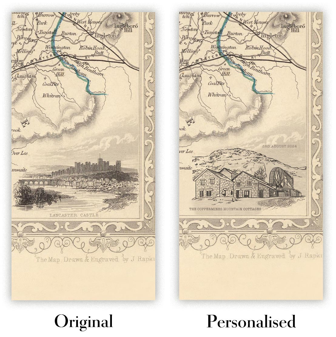
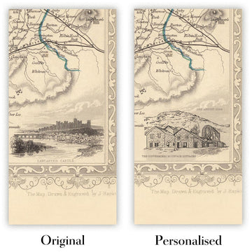
Kartenpersonalisierung
Wenn Sie nach dem perfekten Geschenk zum Jahrestag oder zur Einweihung suchen, kann ich Ihre Karte personalisieren, um sie wirklich einzigartig zu machen. Ich kann beispielsweise eine kurze Nachricht hinzufügen, einen wichtigen Ort hervorheben oder das Wappen Ihrer Familie hinzufügen.
Die Möglichkeiten sind nahezu unbegrenzt. Bitte sehen Sie sich meine Kartenpersonalisierungsseite für einige wunderbare Beispiele dessen, was möglich ist.
Um eine personalisierte Karte zu bestellen, wählen Sie „Personalisieren Sie Ihre Karte“, bevor Sie sie in den Warenkorb legen.
In Kontakt kommen wenn Sie nach komplexeren Anpassungen und Personalisierungen suchen.
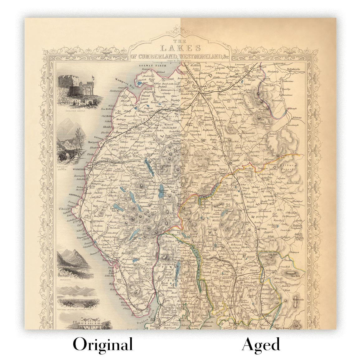
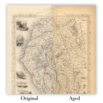
Kartenalterung
Im Laufe der Jahre wurde ich von Kunden hunderte Male gefragt, ob sie eine Karte kaufen könnten, die noch älter.
Nun, jetzt können Sie das, indem Sie „Alter“ auswählen, bevor Sie eine Karte in Ihren Warenkorb legen.
Alle Produktfotos, die Sie auf dieser Seite sehen, zeigen die Karte in ihrer Originalform. So sieht die Karte heute aus.
Wenn Sie „Gealtert“ auswählen, werde ich Ihre Karte von Hand altern lassen. Dazu verwende ich ein spezielles und einzigartiges Verfahren, das ich durch jahrelanges Studium alter Karten und Gespräche mit Forschern zum Verständnis der Chemie alternder Papiere entwickelt habe, und natürlich ... viel Übung!
Wenn Sie sich nicht sicher sind, bleiben Sie bei der Originalfarbe der Karte. Wenn Sie etwas Dunkleres und älter Wenn Sie auf der Suche sind, entscheiden Sie sich für „Aged“.
Sehen Sie einige erstaunliche Beispiele für gealterte Karten.
Wenn Sie aus irgendeinem Grund mit Ihrer Bestellung nicht zufrieden sind, kontaktieren Sie mich für eine unkomplizierte Rückerstattung. Bitte sehen Sie sich unsere Rückgabe- und Rückerstattungsrichtlinien für weitere Informationen an.
Ich bin sehr zuversichtlich, dass Ihnen Ihre restaurierte Karte oder Kunstdruck gefallen wird. Ich mache das seit 1984. Ich bin ein 5-Sterne Etsy-Verkäufer. Ich habe Zehntausende von Karten und Kunstdrucken verkauft und habe über 5.000 echte 5-Sterne-Bewertungen.
Ich verwende einen einzigartigen Prozess, um Karten und Kunstwerke zu restaurieren, der extrem zeitaufwendig und arbeitsintensiv ist. Die Suche nach den Originalkarten und Illustrationen kann Monate dauern. Ich benutze modernste und unglaublich teure Technologie, um sie zu scannen und wiederherzustellen. Daher garantiere ich, dass meine Karten und Kunstdrucke eine Klasse für sich sind - deshalb kann ich eine unkomplizierte Rückerstattung anbieten.
Fast alle meine Karten und Kunstdrucke sehen in großen Größen (200 cm, 6,5 Fuß+) erstaunlich aus und ich kann sie Ihnen auch gerahmt und über einen speziellen Übergrößen-Kurier liefern. Kontaktieren Sie mich, um Ihre speziellen Bedürfnisse zu besprechen.
Or try searching for something!


