

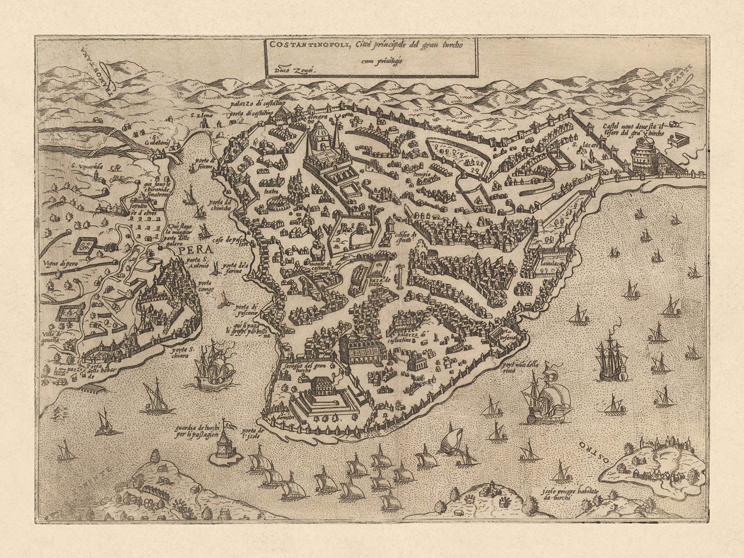


Antike Vogelaugenkarte von Istanbul von Zenoi, 1572: Hagia Sophia, Topkapi-Palast, Hippodrom, Stadtmauern, Goldenes Horn
Kaufe 2, Erhalte 1 Kostenlos
Wenn Sie 2 Artikel in Ihren Warenkorb legen, können Sie ein drittes Produkt kostenlos hinzufügen.
Dies gilt für alle Karten und Kunstwerke, einschließlich individuell gestalteter und personalisierter Stücke. Sie können 3 von derselben Sache oder 3 verschiedene Dinge bestellen.
Das entspricht einem Rabatt von 33 %, der in diesem Jahr der größte Rabatt in meinem Shop sein wird.
Bitte nutzen Sie das Angebot und dekorieren Sie Ihre Wände mit schönen Karten und Kunst!
Kontaktieren Sie mich, wenn Sie Fragen haben.

-
![]() Handmade locally in the EU
Handmade locally in the EU
-
FREE worldwide delivery in 2-3 days ⓘ
Free delivery in 2-3 days
Your map should be delivered in 2-3 working days with free delivery, worldwide.
Deliveries over the Christmas and New Year period may be slightly delayed, as couriers and postal services catch up with a huge backlog of packages.
We make maps by hand locally in 23 countries, including the EU
![]() . If you're buying a gift for someone in another country, we will make the map locally to them.
. If you're buying a gift for someone in another country, we will make the map locally to them.You will never pay import tax or customs duty.
Express delivery is available at checkout which can reduce the delivery time to 1-2 days.
Please note that personalised maps, and larger framed maps, can take longer to produce and deliver.
If you need your order to arrive by a certain date, contact me and we can discuss your options.
-
FREE gift preview
ⓘ
Digital gift preview
After you complete your order, you can send a beautiful digital preview to the gift recipient. Just provide their email address and we'll do the rest. (Their email address will not be stored or used for any other purpose.)
This is perfect if you're concerned that your order might not arrive in time.
You can also buy a real non-expiring gift card, and email it directly to the recipient, so they can buy their own map or artwork.
-
90 day money back guarantee
ⓘ
90 Tage für Rückgabe und Rückerstattung
Produkte können innerhalb von 90 Tagen für eine vollständige Rückerstattung oder einen Umtausch gegen ein anderes Produkt zurückgegeben werden.
Für personalisierte und maßgefertigte Artikel können wir Ihnen möglicherweise einen Gutschein oder eine nicht ablaufende Geschenkkarte anbieten, da wir personalisierte Bestellungen nicht weiterverkaufen können.
Wenn Sie Fragen haben, kontaktieren Sie uns. Für weitere Informationen siehe unsere vollständige Rückgabe- und Umtauschrichtlinie.

My maps are rare, museum-grade, restored old maps sourced from libraries, auction houses and private collections across the globe.
Framing & free personalisation available
1. Select your size
Click here to order a custom size.
2. Frame & personalise your map
Make your map unique with framing, hand-drawn customisation, vintage ageing, pop art text, unique 3D styling and more.


Geschenkmitteilung & individuelle Ausführung

Wenn Sie eine Geschenkmitteilung oder eine Ausführung (Puzzle, Aluminiumplatte usw.) hinzufügen möchten, die hier nicht verfügbar ist, geben Sie dies bitte in der "Bestellnotiz" beim Checkout an.
Jede Bestellung wird individuell angefertigt. Wenn Sie die Größe leicht anpassen oder auf einem ungewöhnlichen Material drucken lassen möchten, lassen Sie es uns einfach wissen. Wir haben im Laufe der Jahre Tausende von individuellen Bestellungen bearbeitet, daher gibt es (fast) nichts, was wir nicht bewältigen können.
Sie können uns auch kontaktieren, bevor Sie bestellen, wenn Sie möchten!

- Handmade locally. No import duty or tax
- FREE worldwide delivery
- Love it or your money back (90 days)
- Questions? WhatsApp me any time
Own a piece of history
5,000+ 5 star reviews


Betreten Sie die Pracht des Konstantinopels des 16. Jahrhunderts mit dieser exquisiten Stadtkarte, ursprünglich betitelt "Constantinopoli; citta principale del gran Turcho." Sie wurde 1572 von dem angesehenen Graveur Domenico Zenoi für Forlanis gefeiertes "Il Primo Libro Delle Citta" geschaffen und dieser Vogelperspektive versetzt Sie ins Herz der glanzvollsten Metropole des Osmanischen Reiches. Die umgekehrte Orientierung der Karte, eine faszinierende kartografische Eigenheit ihrer Zeit, präsentiert die Stadt, als ob sie von der östlichen Küste aus betrachtet wird, und ermöglicht den Betrachtern, ihre einzigartige urbane Silhouette und das komplexe Netzwerk von Befestigungen zu schätzen.
Diese Karte ist ein wahres Schaufenster der architektonischen und kulturellen Schätze Konstantinopels. Die legendäre Hagia Sophia, dargestellt als "Santa Sophia," steht als Zeugnis für das byzantinische und osmanische Erbe der Stadt, während der weitläufige Komplex des Topkapi-Palastes—beschriftet als "Seraglio del gran Turcho"—die historische Halbinsel dominiert. Das Hippodrom, ein Zentrum des öffentlichen Lebens über Jahrhunderte, ist deutlich markiert und lädt den Betrachter ein, sich die Pracht der kaiserlichen Zeremonien und öffentlichen Spektakel vorzustellen, die einst seine Grounds belebt haben.
Ein besonders fesselndes Merkmal ist die detaillierte Illustration der beeindruckenden Stadtmauern und zahlreichen Tore, die das urbane Zentrum umgeben und schützen. Jedes Tor und jeder Turm ist sorgfältig beschriftet und bietet einen seltenen Einblick in die defensive Architektur der Stadt und die strategische Bedeutung ihres Standorts. Das umfangreiche, gekennzeichnete Verzeichnis der Karte identifiziert 57 bedeutende öffentliche Gebäude und Tore, was sie zu einer unschätzbaren Referenz für Historiker und Sammler macht.
Über den Stadtkern hinaus fängt die Karte elegant die lebhaften Ufer des Goldenen Horns und der Bosporusstraße ein, die beide von Schiffen und maritimen Aktivitäten wimmeln. Der Galata-Distrikt, mit eigenen Befestigungen und Türmen, wird prominent über die Bucht dargestellt und spiegelt den kosmopolitischen Charakter dieses geschäftigen Hafens und seine wichtige Rolle im Handel und in der Diplomatie wider. Die Darstellung von Häfen, Docks und lebhaften Wasserszenen unterstreicht weiter Konstantinopels Status als Kreuzung der Kontinente und Kulturen.
Domenico Zenoi's Kunstfertigkeit zeigt sich in den filigranen Details und bildlichen Verzierungen, die diese Karte prägen. Sein Werk dokumentiert nicht nur die physische Anordnung der Stadt, sondern beschwört auch den Geist der Renaissance-Kartografie—wo wissenschaftliche Beobachtung auf imaginative Interpretation trifft. Für Liebhaber historischer Karten ist dieses Stück eine seltene Gelegenheit, ein Fenster in das urbane Gefüge und das tägliche Leben einer der geschichtsträchtigsten Städte der Geschichte zu besitzen, geschaffen von einem Meister seines Handwerks.
Bemerkenswerte Merkmale & Wahrzeichen
- Detaillierte Befestigungen und Stadtmauern, die klar um die Stadt dargestellt sind.
- Prominente Moscheen und religiöse Gebäude, einschließlich der Hagia Sophia (beschriftet als "Santa Sophia").
- Zahlreiche Türme und Tore entlang der Stadtmauern, klar beschriftet und nummeriert.
- Die Bucht des Goldenen Horns prominent illustriert, obwohl geografisch umgekehrt.
- Hafenbereiche und Docks entlang der Ufer dargestellt.
- Schiffe und Boote in den Gewässern um die Stadt illustriert, was die maritime Aktivität betont.
- Das Hippodrom ("Hippodromo") klar beschriftet und illustriert.
- Der Komplex des Topkapi-Palastes ("Seraglio del gran Turcho") prominent illustriert und beschriftet.
- Der Galata-Distrikt über dem Goldenen Horn, klar dargestellt mit Befestigungen und Türmen.
- Die Bucht des Goldenen Horns prominent illustriert.
- Der Bosporus wird dargestellt, obwohl die Orientierung umgekehrt ist.
Historischer und gestalterischer Kontext
- Kartenname: Constantinopoli; citta principale del gran Turcho.
- Erstellungsdatum: 1572 (ursprünglich 1567 graviert).
- Kartenmacher/Verleger: Domenico Zenoi, graviert für Forlanis "Il Primo Libro Delle Citta".
- Die Karte ist bemerkenswert für ihre umgekehrte Orientierung, die Konstantinopel fälschlicherweise am rechten Ufer der Goldenen Hornbucht platziert.
- Dies ist eine bildliche Vogelperspektivkarte, typisch für den kartografischen Stil des 16. Jahrhunderts, die künstlerische Darstellung und detaillierte Illustrationen von Gebäuden, Befestigungen und Stadtlayout betont.
- Die Karte zeigt prominent städtische Befestigungen, bedeutende öffentliche Gebäude, Stadttore und das Gesamtlayout von Konstantinopel (heutiges Istanbul) und spiegelt dessen strategische und kulturelle Bedeutung im 16. Jahrhundert wider.
- Die Karte zeigt spezifisch Konstantinopel (Istanbul), historisch bedeutend als die Hauptstadt des Byzantinischen Reiches und später eine große Stadt unter osmanischer Herrschaft.
- Diese Karte bietet wertvollen historischen Kontext über die städtische Struktur, Architektur und Befestigungen der Stadt während der osmanischen Periode.
- Die Karte enthält ein umfangreiches, schlüsselverziertes Verzeichnis, das 57 bemerkenswerte öffentliche Gebäude und Stadttore identifiziert und detaillierten historischen Kontext und Einblicke in die städtischen Merkmale der Stadt bietet.
Bitte überprüfen Sie die Bilder, um sicherzustellen, dass eine bestimmte Stadt oder ein bestimmter Ort auf dieser Karte dargestellt ist. Sie können uns auch kontaktieren und bitten, die Karte für Sie zu überprüfen.
Diese Karte sieht in jeder Größe großartig aus, aber ich empfehle immer, eine größere Größe zu wählen, wenn Sie Platz haben. So können Sie alle Details leicht erkennen.
Diese Karte sieht in Größen bis zu 70 Zoll (180 cm) erstaunlich aus. Wenn Sie nach einer größeren Karte suchen, bitte kontaktieren Sie uns.
Das Modell in den Angebotsbildern hält die 18x24 Zoll (45x60 cm) Version dieser Karte.
Das fünfte Angebotsbild zeigt ein Beispiel meines Personalisierungsdienstes für Karten.
Wenn Sie nach etwas leicht anderem suchen, schauen Sie sich meine Sammlung der besten alten Karten an, um zu sehen, ob etwas anderes Ihr Interesse weckt.
Bitte kontaktieren Sie mich, um zu überprüfen, ob ein bestimmter Standort, ein Wahrzeichen oder ein Merkmal auf dieser Karte dargestellt ist.
Dies wäre ein wunderbares Geschenk zum Geburtstag, Weihnachten, Vatertag, Abschied von der Arbeit, Jubiläum oder zur Einweihung für jemanden aus den Gebieten, die von dieser Karte abgedeckt sind.
Diese Karte ist als Giclée-Druck auf säurefreiem, archiviertem mattem Papier erhältlich, oder Sie können sie gerahmt kaufen. Der Rahmen ist ein schöner, einfacher schwarzer Rahmen, der zu den meisten Ästhetiken passt. Bitte kontaktieren Sie mich, wenn Sie eine andere Rahmenfarbe oder -material wünschen. Meine Rahmen sind mit superklarem museumsglasähnlichem Acryl (Plexiglas/Acrylt) verglast, das erheblich weniger reflektierend als Glas ist, sicherer und immer in perfektem Zustand ankommt.
This map is also available as a float framed canvas, sometimes known as a shadow gap framed canvas or canvas floater. The map is printed on artist's cotton canvas and then stretched over a handmade box frame. We then "float" the canvas inside a wooden frame, which is available in a range of colours (black, dark brown, oak, antique gold and white). This is a wonderful way to present a map without glazing in front. See some examples of float framed canvas maps and explore the differences between my different finishes.
For something truly unique, this map is also available in "Unique 3D", our trademarked process that dramatically transforms the map so that it has a wonderful sense of depth. We combine the original map with detailed topography and elevation data, so that mountains and the terrain really "pop". For more info and examples of 3D maps, check my Unique 3D page.
Für die meisten Bestellungen beträgt die Lieferzeit etwa 3 Werktage. Personalisierte und maßgeschneiderte Produkte benötigen länger, da ich die Personalisierung durchführen und sie Ihnen zur Genehmigung zusenden muss, was normalerweise 1 oder 2 Tage dauert.
Bitte beachten Sie, dass sehr große gerahmte Bestellungen in der Regel länger für die Herstellung und Lieferung benötigen.
Wenn Sie möchten, dass Ihre Bestellung bis zu einem bestimmten Datum ankommt, bitte kontaktieren Sie mich, bevor Sie bestellen, damit wir den besten Weg finden können, um sicherzustellen, dass Sie Ihre Bestellung rechtzeitig erhalten.
Ich drucke und rahme Karten und Kunstwerke in 23 Ländern weltweit. Das bedeutet, dass Ihre Bestellung lokal gefertigt wird, was die Lieferzeit verkürzt und sicherstellt, dass sie während der Lieferung nicht beschädigt wird. Sie zahlen nie Zoll oder Einfuhrgebühren, und wir stoßen weniger CO2 in die Luft aus.
Alle meine Karten und Kunstdrucke sind gut verpackt und werden in einem robusten Rohr versendet, wenn sie ungerahmt sind, oder von Schaum umgeben, wenn sie gerahmt sind.
Ich versuche, alle Bestellungen innerhalb von 1 oder 2 Tagen nach Erhalt Ihrer Bestellung zu versenden, obwohl einige Produkte (wie Gesichtsmasken, Tassen und Tragetaschen) länger zur Herstellung benötigen können.
Wenn Sie Express-Lieferung an der Kasse auswählen, priorisieren wir Ihre Bestellung und versenden sie per 1-Tages-Kurier (Fedex, DHL, UPS, Parcelforce).
Nächster Tag Lieferung ist auch in einigen Ländern verfügbar (USA, UK, Singapur, VAE), aber bitte versuchen Sie, früh am Tag zu bestellen, damit wir es rechtzeitig versenden können.
Lesen Sie meinen vollständigen Leitfaden zur Lieferung und lokalen Produktion
Mein Standardrahmen ist ein Galerie-Stil-Rahmen aus schwarzem Eschenholz. Er ist einfach und sieht ziemlich modern aus. Mein Standardrahmen ist etwa 20 mm (0,8 Zoll) breit.
Ich verwende super-klares Acryl (Plexiglas/Acrylt) für das Glas des Rahmens. Es ist leichter und sicherer als Glas – und es sieht besser aus, da die Reflexion geringer ist.
Sechs Standardrahmenfarben sind kostenlos erhältlich (schwarz, dunkelbraun, dunkelgrau, Eiche, weiß und antikgold).
Die meisten Karten, Kunstwerke und Illustrationen sind auch als gerahmte Leinwand erhältlich. Wir verwenden matte (nicht glänzende) Baumwollleinwand, spannen sie über einen nachhaltig beschafften Buchenrahmen und 'schweben' dann das Stück innerhalb eines Holzrahmens. Das Endergebnis ist ziemlich schön, und es gibt keine Verglasung, die im Weg ist.
Alle Rahmen werden "bereit zum Aufhängen" geliefert, entweder mit einer Schnur oder Halterungen auf der Rückseite. Sehr große Rahmen haben schwere Aufhängeplatten und/oder eine Montageschiene. Wenn Sie Fragen haben, können Sie bitte Kontakt aufnehmen.
Sehen Sie sich einige Beispiele meiner gerahmten Karten und gerahmten Leinwandkarten an.
Alternativ kann ich auch alte Karten und Kunstwerke auf Leinwand, Schaumstoffplatten, Baumwollrag und andere Materialien liefern.
Wenn Sie Ihre Karte oder Ihr Kunstwerk selbst rahmen möchten, lesen Sie bitte zuerst meinen Größenleitfaden.
Einige meiner alten Karten sind jetzt als gerahmte Leinwände erhältlich. Bitte kontaktiere mich, wenn du eine Größe bestellen möchtest, die in meinem Shop nicht verfügbar ist.
Leinwand alte Karten sind eine interessante Alternative zu konventionell gerahmten Karten. Je nach deinem persönlichen Geschmack und der Raumdekoration können Leinwandkarten etwas mehr „herausstechen“ als eine gerahmte Karte.
Meine Karten sind äußerst hochwertige Reproduktionen von Originalkarten.
Ich beziehe originale, seltene Karten aus Bibliotheken, Auktionshäusern und Privatsammlungen auf der ganzen Welt, restauriere sie in meiner Londoner Werkstatt und erstelle dann mit speziellen Giclée-Tinten und -Druckern wunderschöne Karten, die sogar noch besser aussehen als das Original.
Meine Karten werden auf säurefreiem, mattem Archivpapier (nicht glänzend) gedruckt, das sich sehr hochwertig anfühlt und fast wie Karton aussieht. Technisch gesehen beträgt das Papiergewicht/die Papierdicke 10mil/200g/m². Es eignet sich perfekt zum Einrahmen.
Ich drucke mit UV-lichtbeständigen Ultrachrome-Giclée-Pigmenttinten von Epson – einige der besten Tinten, die Sie finden können.
Ich kann auch machen Karten auf Leinwand, Baumwolllappen und andere exotische Materialien.
Erfahren Sie mehr über The Unique Maps Co.
Kartenpersonalisierung
Wenn Sie nach dem perfekten Geschenk zum Jahrestag oder zur Einweihung suchen, kann ich Ihre Karte personalisieren, um sie wirklich einzigartig zu machen. Ich kann beispielsweise eine kurze Nachricht hinzufügen, einen wichtigen Ort hervorheben oder das Wappen Ihrer Familie hinzufügen.
Die Möglichkeiten sind nahezu unbegrenzt. Bitte sehen Sie sich meine Kartenpersonalisierungsseite für einige wunderbare Beispiele dessen, was möglich ist.
Um eine personalisierte Karte zu bestellen, wählen Sie „Personalisieren Sie Ihre Karte“, bevor Sie sie in den Warenkorb legen.
In Kontakt kommen wenn Sie nach komplexeren Anpassungen und Personalisierungen suchen.
Kartenalterung
Im Laufe der Jahre wurde ich von Kunden hunderte Male gefragt, ob sie eine Karte kaufen könnten, die noch älter.
Nun, jetzt können Sie das, indem Sie „Alter“ auswählen, bevor Sie eine Karte in Ihren Warenkorb legen.
Alle Produktfotos, die Sie auf dieser Seite sehen, zeigen die Karte in ihrer Originalform. So sieht die Karte heute aus.
Wenn Sie „Gealtert“ auswählen, werde ich Ihre Karte von Hand altern lassen. Dazu verwende ich ein spezielles und einzigartiges Verfahren, das ich durch jahrelanges Studium alter Karten und Gespräche mit Forschern zum Verständnis der Chemie alternder Papiere entwickelt habe, und natürlich ... viel Übung!
Wenn Sie sich nicht sicher sind, bleiben Sie bei der Originalfarbe der Karte. Wenn Sie etwas Dunkleres und älter Wenn Sie auf der Suche sind, entscheiden Sie sich für „Aged“.
Sehen Sie einige erstaunliche Beispiele für gealterte Karten.
Wenn Sie aus irgendeinem Grund mit Ihrer Bestellung nicht zufrieden sind, kontaktieren Sie mich für eine unkomplizierte Rückerstattung. Bitte sehen Sie sich unsere Rückgabe- und Rückerstattungsrichtlinien für weitere Informationen an.
Ich bin sehr zuversichtlich, dass Ihnen Ihre restaurierte Karte oder Kunstdruck gefallen wird. Ich mache das seit 1984. Ich bin ein 5-Sterne Etsy-Verkäufer. Ich habe Zehntausende von Karten und Kunstdrucken verkauft und habe über 5.000 echte 5-Sterne-Bewertungen.
Ich verwende einen einzigartigen Prozess, um Karten und Kunstwerke zu restaurieren, der extrem zeitaufwendig und arbeitsintensiv ist. Die Suche nach den Originalkarten und Illustrationen kann Monate dauern. Ich benutze modernste und unglaublich teure Technologie, um sie zu scannen und wiederherzustellen. Daher garantiere ich, dass meine Karten und Kunstdrucke eine Klasse für sich sind - deshalb kann ich eine unkomplizierte Rückerstattung anbieten.
Fast alle meine Karten und Kunstdrucke sehen in großen Größen (200 cm, 6,5 Fuß+) erstaunlich aus und ich kann sie Ihnen auch gerahmt und über einen speziellen Übergrößen-Kurier liefern. Kontaktieren Sie mich, um Ihre speziellen Bedürfnisse zu besprechen.
Or try searching for something!


