


Mappa antica rara di New York City di Phelps, 1857: Central Park, fiume Hudson, vecchie illustrazioni
L’offerta del Collezionista
Scegli due opere idonee e ricevi il 20% di sconto su entrambe. Scegline tre e quella al prezzo più basso è in omaggio, con un risparmio massimo del 33%.
Abbina liberamente mappe standard idonee e stampe d’arte fine art. Non è richiesto alcun codice; l’offerta viene applicata automaticamente al checkout.
Sono incluse le configurazioni standard su ordinazione. Sono esclusi formati su misura, design personalizzati e lavori su commissione.
Hai bisogno di consegne a indirizzi diversi? Contattaci prima di effettuare l’ordine.L’offerta del Collezionista
Scegli due opere idonee e ricevi il 20% di sconto su entrambe. Scegline tre e quella al prezzo più basso è in omaggio, con un risparmio massimo del 33%.
Abbina liberamente mappe standard idonee e stampe d’arte fine art. Non è richiesto alcun codice; l’offerta viene applicata automaticamente al checkout.
Sono incluse le configurazioni standard su ordinazione. Sono esclusi formati su misura, design personalizzati e lavori su commissione.
Hai bisogno di consegne a indirizzi diversi? Contattaci prima di effettuare l’ordine. Progettato a Londra Prodotto nell’UE
Progettato a Londra • Prodotto nell’UE
Progettato a Londra Prodotto nell’UE
Progettato a Londra • Prodotto nell’UE

Restaurata dalla mappa originale del 1857 e stampata in qualità museale. Leggi la storia dietro questa mappa
Choose your size
Choose your finish


(Maggiori informazioni)
Gift message & custom finish

If you want to add a gift message, or a finish (jigsaw, aluminium board, etc.) that is not available here, please request it in the "order note" when you check out.
Every order is custom made, so if you need the size adjusted slightly, or printed on an unusual material, just let us know. We've done thousands of custom orders over the years, so there's (almost) nothing we can't manage.
You can also contact us before you order, if you prefer!

- Prodotto localmente. Consegna sicura
- Nessun dazio o costo nascosto
- Serve aiuto? Chiamaci o messaggio su WhatsApp
Own a piece of history
8,000+ five-star reviews


Scopri il Ricco Arazzo di New York nel XIX Secolo con la Mappa di Phelps Inizia un viaggio storico attraverso la New...
Continua a leggereScopri il Ricco Arazzo di New York nel XIX Secolo con la Mappa di Phelps
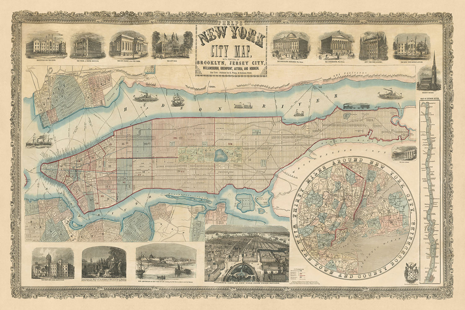
Inizia un viaggio storico attraverso la New York di metà Ottocento con "La Mappa di New York City di Phelps, con Porzioni di Brooklyn, Jersey City, Williamsburgh, Greenpoint, Astoria e Hoboken." Realizzata meticolosamente dal rinomato cartografo Humphrey Phelps nel 1857, questa mappa non è semplicemente uno strumento di navigazione, ma un vibrante documento storico. Cattura la città in un momento cruciale, proprio mentre il grande progetto di Central Park si apprestava a ridefinire gli spazi pubblici urbani. La mappa dettaglia la crescente griglia stradale di Manhattan che si estende verso nord, affiancata da elementi pastorali persistenti come il Serbatoio di Croton e l'ampia distesa pastorale di Jones' Wood, offrendo uno sguardo unico su una città al confine del modernismo urbano.
Una Cronaca Cartografica di Confini in Espansione e Luoghi Culturali
La mappa di Phelps funge da profonda narrazione dell'espansione urbana e dei luoghi culturali. Delinea una serie di quartieri dalle vivaci strade di Lower Manhattan alle regioni meno popolate di Upper Manhattan e oltre. Degne di nota sono le rappresentazioni dettagliate di aree emergenti come Astoria e Greenpoint, accanto a luoghi consolidati come Wall Street e The Battery. L'attenzione della mappa ai fiumi Hudson, East e Harlem sottolinea il loro ruolo cruciale nel panorama economico e geografico della città. Questa mappa non solo traccia spazi fisici, ma celebra anche i successi architettonici e istituzionali di New York, dal iconico Castle Garden al baluardo educativo della Cooper Union.
Vignette della Vita Urbana e dell'Ethos
Ciò che distingue questa mappa sono le intricate vignette incise su legno che bordano la mappa, ognuna raccontando la propria storia della vita urbana multifaccettata di New York. Dalla famigerata prigione Tombs all'affollato Merchants' Exchange di Wall Street, queste illustrazioni offrono una finestra sulle vite quotidiane e sulle strutture sociali dei newyorkesi di quest'epoca. Riflettono una città profondamente impegnata in istituzioni diversificate, che siano penali, educative o mercantili. L'inclusione di vignette come l'Orfanotrofio di New York e l'Istituto dei Sordi e Muti evidenzia un approccio compassionevole alle sfide sociali, ritraendo una comunità in bilico tra un passato storicizzato e un futuro progressista.
Una Riflesso della Prowess Educativa e Intellettuale di New York
Tra la rappresentazione della mappa di strade e luoghi, c'è una forte enfasi sull'impegno di New York City per l'istruzione e la crescita intellettuale. Istituzioni come la New York Free Academy (poi City College) e la fiorente Cooper Union sono messe in evidenza, sottolineando la visione della città come centro di conoscenza e innovazione. Questo focus è una testimonianza del riconoscimento da parte della città dell'istruzione come fondamentale per il miglioramento civico e l'avanzamento sociale. La mappa, quindi, fa più che rappresentare caratteristiche geografiche; promuove lo spirito intellettuale della sua epoca.
Un Gioiello Cartografico da un'Era Trasformativa
Questa mappa non è solo un oggetto da collezione, ma un portale a un periodo trasformativo nella storia di New York City. Pubblicata sul bordo del progetto di Central Park, cattura il preludio a uno dei più significativi sviluppi urbani nella storia americana. La mappa di Phelps, con la sua rappresentazione dettagliata di strade, parchi e fiumi, insieme ai suoi ricchi elementi decorativi, offre uno strumento senza pari per comprendere l'evoluzione storica e culturale di New York City. Rimane un pezzo fondamentale per storici, cartografi e chiunque sia affascinato dalla complessa trama che è New York.
Strade e vie su questa mappa
- 10th Avenue
- 12th Street
- 13th Street
- 14th Street
- 15th Street
- 16th Street
- 17th Street
- 18th Street
- 19th Street
- 20th Street
- 21st Street
- 22nd Street
- 23rd Street
- 24th Street
- 25th Street
- 26th Street
- 27th Street
- 28th Street
- 29th Street
- 30th Street
- 31st Street
- 32nd Street
- 33rd Street
- 34th Street
- 35th Street
- 36th Street
- 37th Street
- 38th Street
- 39th Street
- 40th Street
Caratteristiche & Luoghi Notabili
- Central Park
- Croton Reservoir
- Jones' Wood
- Harlem Common
- Mount Morris Square
- Tompkins Square
- Stuyvesant Square
- Washington Square
- The Battery
- Castle Garden
- Ellis Island
- Governor's Island
- Liberty Island
- Blackwell's Island
- Randall's Island
- Wards Island
- Brooklyn Navy Yard
- Wallabout Bay
- Newtown Creek
- Flushing Bay
- Astoria
- Greenpoint
- Williamsburg
- Jersey City
- Hoboken
- Weehawken
- Union City
- Bergen
- Guttenberg
- West Hoboken
- Palisades
- Hudson River
- East River
- Harlem River
- Arthur Kill
- Newark Bay
- Kill Van Kull
- Staten Island
- New Jersey
- New York City
Contesto storico e di design
- Pubblicata da Humphrey Phelps nel 1857
- Riflette l'era appena prima della creazione di Central Park
- Abbellita con vignette incise su legno che evidenziano edifici pubblici chiave e vita urbana
- Include mappe tematiche e mappe politiche e fisiche dettagliate
- Presenta vignette come "La prigione della città, chiamata Le Tombe" e "La Borsa dei Mercanti, Wall Street"
- Illustra l'impegno della città verso istituzioni varie—educative, penali, religiose e mercantili
- Mette in evidenza l'emergente enfasi della città sull'istruzione e la crescita intellettuale
- Rivela il lato compassionevole dell'espansione urbana e l'etica inclusiva
Si prega di controllare attentamente le immagini per assicurarsi che una specifica città o luogo sia mostrato su questa mappa. Puoi anche contattarci e chiedere di controllare la mappa per te.
Questa mappa appare fantastica in ogni dimensione, ma consiglio sempre di optare per una dimensione più grande se hai spazio. In questo modo puoi facilmente distinguere tutti i dettagli.
Questa mappa appare incredibile in dimensioni fino a 100in (250cm). Se stai cercando una mappa più grande, per favore contattaci.
Si prega di notare: le etichette su questa mappa sono difficili da leggere se si ordina una mappa che è di 36 pollici (90 cm) o più piccola. La mappa è comunque molto attraente, ma se desideri leggere facilmente la mappa, ti preghiamo di acquistare una dimensione più grande.
Questa mappa è più ampia della maggior parte delle mappe, il che la renderebbe un pezzo d'affermazione perfetto sopra un camino, un divano o una scrivania.
La quinta immagine dell'elenco mostra un esempio del mio servizio di personalizzazione della mappa.
Se stai cercando qualcosa di leggermente diverso, dai un'occhiata alla mia collezione delle migliori mappe antiche per vedere se qualcosa attira la tua attenzione.
Si prega di contattarmi per verificare se una certa posizione, un punto di riferimento o una caratteristica è mostrata su questa mappa.
Questo sarebbe un meraviglioso regalo per un compleanno, Natale, Festa del Papà, congedo dal lavoro, anniversario o inaugurazione della casa per qualcuno delle aree coperte da questa mappa.
Questa mappa è disponibile come stampa giclée su carta opaca archiviata senza acidi, oppure puoi acquistarla incorniciata. La cornice è una semplice cornice nera che si adatta alla maggior parte delle estetiche. Ti preghiamo di contattarmi se desideri un colore o un materiale della cornice diverso. Le mie cornici sono rivestite con acrilico super chiaro di grado museale (perspex/acrylite), che è significativamente meno riflettente del vetro, più sicuro e arriverà sempre in perfette condizioni.
This map is also available as a float framed canvas, sometimes known as a shadow gap framed canvas or canvas floater. The map is printed on artist's cotton canvas and then stretched over a handmade box frame. We then "float" the canvas inside a wooden frame, which is available in a range of colours (black, dark brown, oak, antique gold and white). This is a wonderful way to present a map without glazing in front. See some examples of float framed canvas maps and explore the differences between my different finishes.
For something truly unique, this map is also available in "Unique 3D", our trademarked process that dramatically transforms the map so that it has a wonderful sense of depth. We combine the original map with detailed topography and elevation data, so that mountains and the terrain really "pop". For more info and examples of 3D maps, check my Unique 3D page.
Scopri il Ricco Arazzo di New York nel XIX Secolo con la Mappa di Phelps
Inizia un viaggio storico attraverso la New York di metà Ottocento con "La Mappa di New York City di Phelps, con Porzioni di Brooklyn, Jersey City, Williamsburgh, Greenpoint, Astoria e Hoboken." Realizzata meticolosamente dal rinomato cartografo Humphrey Phelps nel 1857, questa mappa non è semplicemente uno strumento di navigazione, ma un vibrante documento storico. Cattura la città in un momento cruciale, proprio mentre il grande progetto di Central Park si apprestava a ridefinire gli spazi pubblici urbani. La mappa dettaglia la crescente griglia stradale di Manhattan che si estende verso nord, affiancata da elementi pastorali persistenti come il Serbatoio di Croton e l'ampia distesa pastorale di Jones' Wood, offrendo uno sguardo unico su una città al confine del modernismo urbano.
Una Cronaca Cartografica di Confini in Espansione e Luoghi Culturali
La mappa di Phelps funge da profonda narrazione dell'espansione urbana e dei luoghi culturali. Delinea una serie di quartieri dalle vivaci strade di Lower Manhattan alle regioni meno popolate di Upper Manhattan e oltre. Degne di nota sono le rappresentazioni dettagliate di aree emergenti come Astoria e Greenpoint, accanto a luoghi consolidati come Wall Street e The Battery. L'attenzione della mappa ai fiumi Hudson, East e Harlem sottolinea il loro ruolo cruciale nel panorama economico e geografico della città. Questa mappa non solo traccia spazi fisici, ma celebra anche i successi architettonici e istituzionali di New York, dal iconico Castle Garden al baluardo educativo della Cooper Union.
Vignette della Vita Urbana e dell'Ethos
Ciò che distingue questa mappa sono le intricate vignette incise su legno che bordano la mappa, ognuna raccontando la propria storia della vita urbana multifaccettata di New York. Dalla famigerata prigione Tombs all'affollato Merchants' Exchange di Wall Street, queste illustrazioni offrono una finestra sulle vite quotidiane e sulle strutture sociali dei newyorkesi di quest'epoca. Riflettono una città profondamente impegnata in istituzioni diversificate, che siano penali, educative o mercantili. L'inclusione di vignette come l'Orfanotrofio di New York e l'Istituto dei Sordi e Muti evidenzia un approccio compassionevole alle sfide sociali, ritraendo una comunità in bilico tra un passato storicizzato e un futuro progressista.
Una Riflesso della Prowess Educativa e Intellettuale di New York
Tra la rappresentazione della mappa di strade e luoghi, c'è una forte enfasi sull'impegno di New York City per l'istruzione e la crescita intellettuale. Istituzioni come la New York Free Academy (poi City College) e la fiorente Cooper Union sono messe in evidenza, sottolineando la visione della città come centro di conoscenza e innovazione. Questo focus è una testimonianza del riconoscimento da parte della città dell'istruzione come fondamentale per il miglioramento civico e l'avanzamento sociale. La mappa, quindi, fa più che rappresentare caratteristiche geografiche; promuove lo spirito intellettuale della sua epoca.
Un Gioiello Cartografico da un'Era Trasformativa
Questa mappa non è solo un oggetto da collezione, ma un portale a un periodo trasformativo nella storia di New York City. Pubblicata sul bordo del progetto di Central Park, cattura il preludio a uno dei più significativi sviluppi urbani nella storia americana. La mappa di Phelps, con la sua rappresentazione dettagliata di strade, parchi e fiumi, insieme ai suoi ricchi elementi decorativi, offre uno strumento senza pari per comprendere l'evoluzione storica e culturale di New York City. Rimane un pezzo fondamentale per storici, cartografi e chiunque sia affascinato dalla complessa trama che è New York.
Strade e vie su questa mappa
- 10th Avenue
- 12th Street
- 13th Street
- 14th Street
- 15th Street
- 16th Street
- 17th Street
- 18th Street
- 19th Street
- 20th Street
- 21st Street
- 22nd Street
- 23rd Street
- 24th Street
- 25th Street
- 26th Street
- 27th Street
- 28th Street
- 29th Street
- 30th Street
- 31st Street
- 32nd Street
- 33rd Street
- 34th Street
- 35th Street
- 36th Street
- 37th Street
- 38th Street
- 39th Street
- 40th Street
Caratteristiche & Luoghi Notabili
- Central Park
- Croton Reservoir
- Jones' Wood
- Harlem Common
- Mount Morris Square
- Tompkins Square
- Stuyvesant Square
- Washington Square
- The Battery
- Castle Garden
- Ellis Island
- Governor's Island
- Liberty Island
- Blackwell's Island
- Randall's Island
- Wards Island
- Brooklyn Navy Yard
- Wallabout Bay
- Newtown Creek
- Flushing Bay
- Astoria
- Greenpoint
- Williamsburg
- Jersey City
- Hoboken
- Weehawken
- Union City
- Bergen
- Guttenberg
- West Hoboken
- Palisades
- Hudson River
- East River
- Harlem River
- Arthur Kill
- Newark Bay
- Kill Van Kull
- Staten Island
- New Jersey
- New York City
Contesto storico e di design
- Pubblicata da Humphrey Phelps nel 1857
- Riflette l'era appena prima della creazione di Central Park
- Abbellita con vignette incise su legno che evidenziano edifici pubblici chiave e vita urbana
- Include mappe tematiche e mappe politiche e fisiche dettagliate
- Presenta vignette come "La prigione della città, chiamata Le Tombe" e "La Borsa dei Mercanti, Wall Street"
- Illustra l'impegno della città verso istituzioni varie—educative, penali, religiose e mercantili
- Mette in evidenza l'emergente enfasi della città sull'istruzione e la crescita intellettuale
- Rivela il lato compassionevole dell'espansione urbana e l'etica inclusiva
Si prega di controllare attentamente le immagini per assicurarsi che una specifica città o luogo sia mostrato su questa mappa. Puoi anche contattarci e chiedere di controllare la mappa per te.
Questa mappa appare fantastica in ogni dimensione, ma consiglio sempre di optare per una dimensione più grande se hai spazio. In questo modo puoi facilmente distinguere tutti i dettagli.
Questa mappa appare incredibile in dimensioni fino a 100in (250cm). Se stai cercando una mappa più grande, per favore contattaci.
Si prega di notare: le etichette su questa mappa sono difficili da leggere se si ordina una mappa che è di 36 pollici (90 cm) o più piccola. La mappa è comunque molto attraente, ma se desideri leggere facilmente la mappa, ti preghiamo di acquistare una dimensione più grande.
Questa mappa è più ampia della maggior parte delle mappe, il che la renderebbe un pezzo d'affermazione perfetto sopra un camino, un divano o una scrivania.
La quinta immagine dell'elenco mostra un esempio del mio servizio di personalizzazione della mappa.
Se stai cercando qualcosa di leggermente diverso, dai un'occhiata alla mia collezione delle migliori mappe antiche per vedere se qualcosa attira la tua attenzione.
Si prega di contattarmi per verificare se una certa posizione, un punto di riferimento o una caratteristica è mostrata su questa mappa.
Questo sarebbe un meraviglioso regalo per un compleanno, Natale, Festa del Papà, congedo dal lavoro, anniversario o inaugurazione della casa per qualcuno delle aree coperte da questa mappa.
Questa mappa è disponibile come stampa giclée su carta opaca archiviata senza acidi, oppure puoi acquistarla incorniciata. La cornice è una semplice cornice nera che si adatta alla maggior parte delle estetiche. Ti preghiamo di contattarmi se desideri un colore o un materiale della cornice diverso. Le mie cornici sono rivestite con acrilico super chiaro di grado museale (perspex/acrylite), che è significativamente meno riflettente del vetro, più sicuro e arriverà sempre in perfette condizioni.
This map is also available as a float framed canvas, sometimes known as a shadow gap framed canvas or canvas floater. The map is printed on artist's cotton canvas and then stretched over a handmade box frame. We then "float" the canvas inside a wooden frame, which is available in a range of colours (black, dark brown, oak, antique gold and white). This is a wonderful way to present a map without glazing in front. See some examples of float framed canvas maps and explore the differences between my different finishes.
For something truly unique, this map is also available in "Unique 3D", our trademarked process that dramatically transforms the map so that it has a wonderful sense of depth. We combine the original map with detailed topography and elevation data, so that mountains and the terrain really "pop". For more info and examples of 3D maps, check my Unique 3D page.
Many of our maps and art prints are chosen as thoughtful gifts for homes, offices, studies and meaningful places.
Choose a framed option for the easiest ready-to-hang gift, or choose an unframed print if the recipient may prefer to select their own frame.
We make orders locally in 23 countries around the world, so gifts can often be produced close to the recipient. This helps them arrive faster, travel more safely, and avoid customs or import duty surprises.
- We can deliver directly to the recipient
- Framed pieces arrive ready to hang
- Unframed prints are carefully packed in a strong protective tube
- Almost every order is made locally, for faster, safer gifting
- 90-day returns give the recipient time to decide
If you are not sure what to choose, please contact us. We can help you pick the right map, size, finish or delivery option.
Most orders are made locally and delivered in around 2–3 working days, depending on the product, size and destination.
We print and frame maps and artwork in 23 countries around the world, so your order is usually made close to you or your recipient. That means faster delivery, less time in transit, and no customs or import duty surprises.
Personalised and customised pieces usually take an extra 1–2 working days, because we prepare your design and send it to you for approval before printing.
Very large framed orders can take a little longer, as they need extra care in production and delivery.
Every order is carefully packaged: unframed prints are sent in a strong protective tube, while framed pieces are securely packed with protective materials around the frame.
If you need your order by a particular date, please contact us before ordering. We’ll check the best production route and delivery option for your location.
Express delivery is available at checkout for most countries. Next-day delivery is available in the UK, US, Singapore and the UAE.
Your order is covered by our 90-day returns policy and 10-year guarantee.
Our standard frame is a gallery-style black ash hardwood frame, with a simple, modern look. It is approximately 20mm (0.8in) wide. You can also view some lovely customer photos of framed maps and art.
We use super-clear acrylic glazing, also known as Perspex or Acrylite, instead of traditional glass. It is lighter, safer, and has lower reflectivity, giving the artwork a clearer, cleaner appearance.
Six standard frame colours are available at no extra cost: black, dark brown, dark grey, oak, white, and antique gold. Custom framing and mounting/matting is also available for customers looking for something more specific.
Most maps, art prints, and illustrations are also available as a framed canvas. We use matte cotton canvas, stretch it over a sustainably sourced wooden box frame, and then float the piece within a wooden outer frame. The finished result is beautifully presented, with no glazing between you and the artwork.
All frames are supplied ready to hang, with either string or brackets fitted to the back. Very large frames will include heavy-duty hanging plates and/or a mounting baton. If you have any questions, please get in touch.
We can also supply old maps and artwork on canvas, foam board, cotton rag, and other materials.
If you would prefer to frame your map or artwork yourself, please read our size guide before ordering.
My maps are extremely high quality reproductions of original maps.
I source original, rare maps from libraries, auction houses and private collections around the world, restore them at my London workshop, and then use specialist giclée inks and printers to create beautiful maps that look even better than the original.
My maps are printed on acid-free archival matte (not glossy) paper that feels very high quality and almost like card. In technical terms the paper weight/thickness is 10mil/200gsm. It's perfect for framing.
I print with Epson ultrachrome giclée UV fade resistant pigment inks - some of the best inks you can find.
I can also make maps on canvas, cotton rag and other exotic materials.
Learn more about The Unique Maps Co.
Map personalisation
If you're looking for the perfect anniversary or housewarming gift, I can personalise your map to make it truly unique. For example, I can add a short message, or highlight an important location, or add your family's coat of arms.
The options are almost infinite. Please see my map personalisation page for some wonderful examples of what's possible.
To order a personalised map, select "personalise your map" before adding it to your basket.
Get in touch if you're looking for more complex customisations and personalisations.
Map ageing
I have been asked hundreds of times over the years by customers if they could buy a map that looks even older.
Well, now you can, by selecting Aged before you add a map to your basket.
All the product photos you see on this page show the map in its Original form. This is what the map looks like today.
If you select Aged, I will age your map by hand, using a special and unique process developed through years of studying old maps, talking to researchers to understand the chemistry of aging paper, and of course... lots of practice!
If you're unsure, stick to the Original colour of the map. If you want something a bit darker and older looking, go for Aged.
Se non sei soddisfatto del tuo ordine per qualsiasi motivo, contattami per un rimborso senza problemi. Si prega di consultare la nostra politica di reso e rimborso per ulteriori informazioni.
Sono molto sicuro che ti piacerà la tua mappa restaurata o la stampa d'arte. Lo faccio dal 1984. Sono un venditore Etsy a 5 stelle. Ho venduto decine di migliaia di mappe e stampe d'arte e ho oltre 5.000 recensioni reali a 5 stelle.
Utilizzo un processo unico per restaurare mappe e opere d'arte che richiede molto tempo e lavoro. Trovare le mappe e le illustrazioni originali può richiedere mesi. Utilizzo tecnologia all'avanguardia e incredibilmente costosa per scannerizzare e restaurarle. Di conseguenza, garantisco che le mie mappe e stampe d'arte siano superiori alle altre - ecco perché posso offrire un rimborso senza problemi.
Quasi tutte le mie mappe e stampe d'arte sembrano fantastiche a grandi dimensioni (200 cm, 6,5 piedi+) e posso anche incorniciarle e consegnarle a te, tramite un corriere speciale per oggetti di grandi dimensioni. Contattami per discutere delle tue esigenze specifiche.
Or try searching for something!


