


Antica mappa della Finlandia, Danimarca e dei Paesi Baltici di Tallis, 1851: San Pietroburgo, Stoccolma, Riga, Gotland, Golfo di Finlandia
20% di sconto su 2 — 33% di sconto su 3
Aggiungi qualsiasi due articoli idonei al tuo carrello per ricevere 20% di sconto. Aggiungi un terzo e sarà gratuito (equivalente a 33% di sconto quando acquisti tre).
Nessun codice necessario — l'offerta si applica automaticamente al checkout.
Valido su tutte le mappe standard e le stampe d'arte fine. Puoi mescolare e abbinare qualsiasi design.
Se desideri spedire articoli a più indirizzi, ti preghiamo di contattarci prima di effettuare il tuo ordine.
Le commissioni personalizzate e su misura sono escluse.
Contattaci se hai domande
 Progettato a Londra Prodotto nell’UE
Progettato a Londra • Prodotto nell’UE
Progettato a Londra Prodotto nell’UE
Progettato a Londra • Prodotto nell’UE

Choose your size
Choose your finish


(Maggiori informazioni)
Gift message & custom finish

If you want to add a gift message, or a finish (jigsaw, aluminium board, etc.) that is not available here, please request it in the "order note" when you check out.
Every order is custom made, so if you need the size adjusted slightly, or printed on an unusual material, just let us know. We've done thousands of custom orders over the years, so there's (almost) nothing we can't manage.
You can also contact us before you order, if you prefer!

- Made locally for fast, safe delivery
- No import duty or hidden fees
- Need advice? Message us on WhatsApp
Own a piece of history
7,000+ 5 star reviews


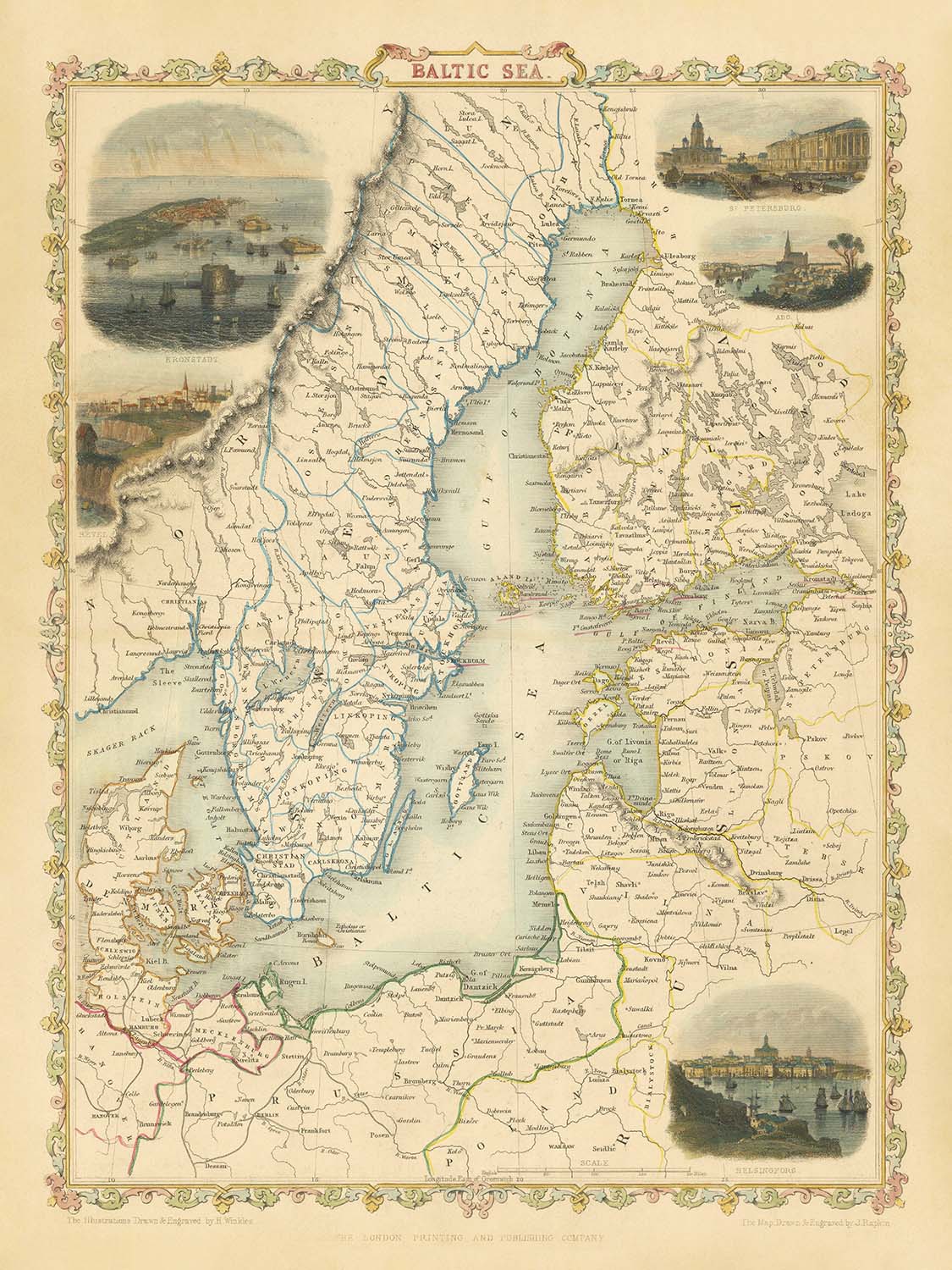
Entra nel mondo intricato della cartografia della metà del XIX secolo con l'esquisita mappa del "Mar Baltico", pubblicata originariamente nel 1851 dal celebre duo John Tallis e John Rapkin. Con il titolo originale "Mar Baltico", quest'opera magistrale cattura lo spirito di un'epoca in cui la regione baltica si trovava all'incrocio di imperi, commercio e cultura. I caratteristici bordi decorativi di Tallis e l'incisione precisa di Rapkin invitano l'osservatore a esplorare non solo il paesaggio geografico ma anche quello artistico del tempo, rendendo questa mappa un vero e proprio artefatto affascinante per collezionisti e intenditori.
John Tallis, una luminaria dell'editoria dell'era vittoriana, era rinomato per la sua capacità di unire accuratezza ed eleganza. Le sue mappe, spesso adornate con vignette ornate e colorazione a mano, divennero beni preziosi nei salotti e nelle biblioteche di tutta Europa. Collaborando con l'abile incisore John Rapkin, Tallis diede vita al complesso arazzo della regione baltica—un'area che, nel 1851, era un nodo di confini in cambiamento e identità nazionali in crescita. La loro partnership ha prodotto una mappa che è tanto un documento storico quanto un'opera d'arte.
La rappresentazione meticolosamente dettagliata del Mar Baltico e delle sue terre circostanti è una testimonianza dell'impegno dei cartografi sia per la bellezza che per la precisione. Le coste di Svezia, Finlandia, Russia, Estonia, Lettonia, Lituania, Polonia e Germania sono tutte elegantemente delineate, con i confini politici dell'epoca chiaramente segnati. Le iconiche isole del Baltico—Gotland, Öland, l'arcipelago di Åland e Saaremaa—sono rappresentate con cura, evidenziando la loro importanza strategica e culturale. Il Golfo di Finlandia e il Golfo di Botnia, arterie vitali per il commercio e i viaggi, sono etichettati in modo prominente, ancorando lo sguardo dell'osservatore al cuore dell'Europa settentrionale.
Ciò che distingue davvero questa mappa sono le incantevoli illustrazioni vignettate che incorniciano la cartografia centrale. Scene di Kronstadt, San Pietroburgo, Revel (Tallinn), Abo (Turku) e Helsingfors (Helsinki) evocano la grandiosità e la diversità delle città della regione, ognuna un centro di attività marittima e scambio culturale. Queste vignette non solo migliorano l'appeal estetico della mappa, ma servono anche come finestre sulla vita quotidiana e sulla splendore architettonico dei porti più storici del Baltico.
Storicamente, questa mappa si erge come un testimone raro e prezioso di un periodo di profonda trasformazione. Il Mar Baltico, a lungo un teatro per ambizioni imperiali e imprese mercantili, è presentato qui in un momento in cui il vecchio ordine cedeva il passo a nuove aspirazioni nazionali. La scarsità della mappa—diversa dalle più comuni viste di Tallis/Martin—aggiunge al suo fascino, rendendola un tesoro singolare per coloro che apprezzano l'intersezione di storia, geografia e belle arti. Per il collezionista esigente, questa mappa offre non solo uno sguardo al passato, ma una connessione tangibile all'eredità duratura della cartografia europea.
Città e paesi su questa mappa
-
Russia
- San Pietroburgo (St. Petersburg)
- Kronstadt
-
Finlandia
- Helsinki (Helsingfors)
- Turku (Abo)
-
Estonia
- Tallinn (Revel)
-
Svezia
- Stoccolma
-
Lettonia
- Riga
-
Lituania
- Klaipėda (Memel)
-
Polonia
- Gdańsk (Danzig)
-
Germania
- Lübeck
Caratteristiche e monumenti notevoli
- Il Mar Baltico (caratteristica centrale)
- Golfo di Finlandia (etichettato e raffigurato)
- Golfo di Botnia (etichettato e raffigurato)
- Principali isole baltiche: Gotland, Öland, Isole Åland, Saaremaa (Oesel)
- Confini politici tra paesi e regioni nel 1851
- Incisioni artistiche (vignette) di Kronstadt, San Pietroburgo, Revel (Tallinn), Abo (Turku) e Helsingfors (Helsinki)
- Rappresentazione dettagliata della costa del Mar Baltico, comprese penisole e arcipelaghi
- Bordo ornato che incornicia la mappa
- Cartouche del titolo con elementi decorativi
Contesto storico e di design
- Creato da John Tallis & John Rapkin, noti per le loro mappe decorative e dettagliate a metà del XIX secolo
- Datato 1851, riflette il panorama politico e geografico della regione baltica durante l'inizio dell'era vittoriana
- Presenta colori vivaci con colorazione a mano probabilmente applicata dopo la stampa
- Non è una delle viste standard di John Tallis / R. Montgomery Martin, rendendola un oggetto da collezione raro e prezioso
- Fornisce un'istantanea della regione baltica in un periodo di imperi e confini nazionali in cambiamento
- Vignette decorative aggiungono valore artistico e storico, raffigurando luoghi e scene significative
- Riflette l'importanza geopolitica del Mar Baltico per il commercio, la navigazione e il potere regionale
Si prega di controllare attentamente le immagini per assicurarsi che una specifica città o luogo sia mostrato su questa mappa. Puoi anche contattarci e chiedere di controllare la mappa per te.
Questa mappa appare fantastica in ogni dimensione, ma consiglio sempre di optare per una dimensione più grande se hai spazio. In questo modo puoi facilmente distinguere tutti i dettagli.
Questa mappa sembra incredibile in dimensioni fino a 50 pollici (125 cm). Se stai cercando una mappa più grande, per favore contattaci.
Il modello nelle immagini dell'elenco tiene la versione 18x24 pollici (45x60 cm) di questa mappa.
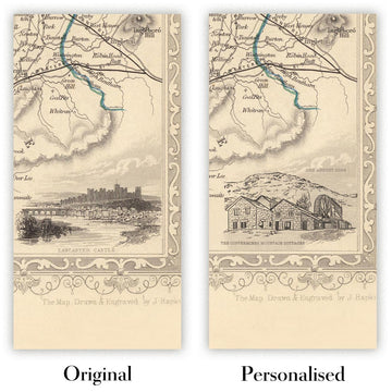
La quinta immagine dell'elenco mostra un esempio del mio servizio di personalizzazione della mappa.
Se stai cercando qualcosa di leggermente diverso, dai un'occhiata alla mia collezione delle migliori mappe antiche per vedere se qualcosa attira la tua attenzione.
Per favore contattami per verificare se una certa posizione, monumento o caratteristica è mostrata su questa mappa.
Questa sarebbe un meraviglioso regalo per compleanni, Natale, festa del papà, addio al lavoro, anniversario o inaugurazione della casa per qualcuno delle aree coperte da questa mappa.
Questa mappa è disponibile come stampa giclée su carta opaca archivistica senza acidi, oppure puoi acquistarla incorniciata. La cornice è una semplice cornice nera che si adatta alla maggior parte degli stili. Ti prego di contattarmi se desideri un colore o un materiale diverso per la cornice. Le mie cornici sono dotate di un acrilico museo super chiaro (perspex/acrylite), che è significativamente meno riflettente del vetro, più sicuro e arriverà sempre in perfette condizioni.
This map is also available as a float framed canvas, sometimes known as a shadow gap framed canvas or canvas floater. The map is printed on artist's cotton canvas and then stretched over a handmade box frame. We then "float" the canvas inside a wooden frame, which is available in a range of colours (black, dark brown, oak, antique gold and white). This is a wonderful way to present a map without glazing in front. See some examples of float framed canvas maps and explore the differences between my different finishes.
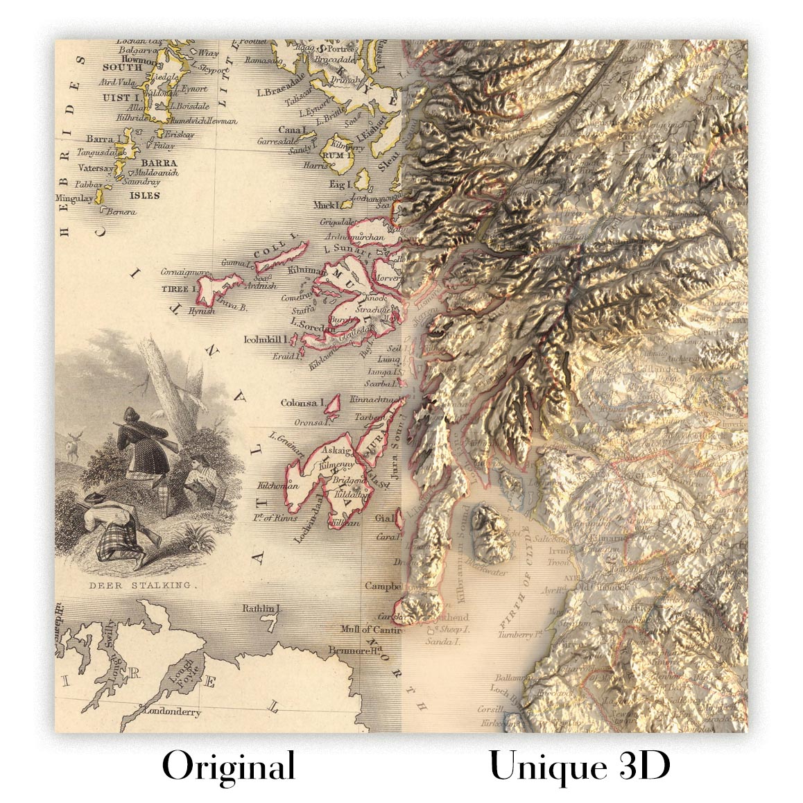
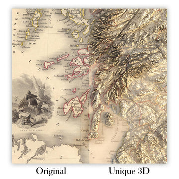
For something truly unique, this map is also available in "Unique 3D", our trademarked process that dramatically transforms the map so that it has a wonderful sense of depth. We combine the original map with detailed topography and elevation data, so that mountains and the terrain really "pop". For more info and examples of 3D maps, check my Unique 3D page.
Many of our maps and art prints are chosen as thoughtful gifts for homes, offices, studies and meaningful places.
Choose a framed option for the easiest ready-to-hang gift, or choose an unframed print if the recipient may prefer to select their own frame.
We make orders locally in 23 countries around the world, so gifts can often be produced close to the recipient. This helps them arrive faster, travel more safely, and avoid customs or import duty surprises.
- We can deliver directly to the recipient
- Framed pieces arrive ready to hang
- Unframed prints are carefully packed in a strong protective tube
- Almost every order is made locally, for faster, safer gifting
- 90-day returns give the recipient time to decide
If you are not sure what to choose, please contact us. We can help you pick the right map, size, finish or delivery option.
Most orders are made locally and delivered in around 2–3 working days, depending on the product, size and destination.
We print and frame maps and artwork in 23 countries around the world, so your order is usually made close to you or your recipient. That means faster delivery, less time in transit, and no customs or import duty surprises.
Personalised and customised pieces usually take an extra 1–2 working days, because we prepare your design and send it to you for approval before printing.
Very large framed orders can take a little longer, as they need extra care in production and delivery.
Every order is carefully packaged: unframed prints are sent in a strong protective tube, while framed pieces are securely packed with protective materials around the frame.
If you need your order by a particular date, please contact us before ordering. We’ll check the best production route and delivery option for your location.
Express delivery is available at checkout for most countries. Next-day delivery is available in the UK, US, Singapore and the UAE.
Your order is covered by our 90-day returns policy and 10-year guarantee.
Our standard frame is a gallery-style black ash hardwood frame, with a simple, modern look. It is approximately 20mm (0.8in) wide. You can also view some lovely customer photos of framed maps and art.
We use super-clear acrylic glazing, also known as Perspex or Acrylite, instead of traditional glass. It is lighter, safer, and has lower reflectivity, giving the artwork a clearer, cleaner appearance.
Six standard frame colours are available at no extra cost: black, dark brown, dark grey, oak, white, and antique gold. Custom framing and mounting/matting is also available for customers looking for something more specific.
Most maps, art prints, and illustrations are also available as a framed canvas. We use matte cotton canvas, stretch it over a sustainably sourced wooden box frame, and then float the piece within a wooden outer frame. The finished result is beautifully presented, with no glazing between you and the artwork.
All frames are supplied ready to hang, with either string or brackets fitted to the back. Very large frames will include heavy-duty hanging plates and/or a mounting baton. If you have any questions, please get in touch.
We can also supply old maps and artwork on canvas, foam board, cotton rag, and other materials.
If you would prefer to frame your map or artwork yourself, please read our size guide before ordering.
My maps are extremely high quality reproductions of original maps.
I source original, rare maps from libraries, auction houses and private collections around the world, restore them at my London workshop, and then use specialist giclée inks and printers to create beautiful maps that look even better than the original.
My maps are printed on acid-free archival matte (not glossy) paper that feels very high quality and almost like card. In technical terms the paper weight/thickness is 10mil/200gsm. It's perfect for framing.
I print with Epson ultrachrome giclée UV fade resistant pigment inks - some of the best inks you can find.
I can also make maps on canvas, cotton rag and other exotic materials.
Learn more about The Unique Maps Co.
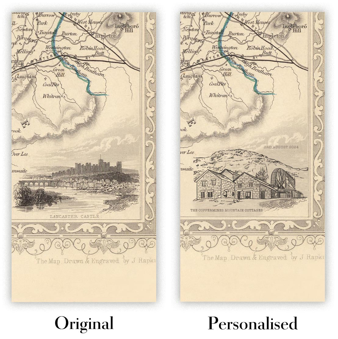
Map personalisation
If you're looking for the perfect anniversary or housewarming gift, I can personalise your map to make it truly unique. For example, I can add a short message, or highlight an important location, or add your family's coat of arms.
The options are almost infinite. Please see my map personalisation page for some wonderful examples of what's possible.
To order a personalised map, select "personalise your map" before adding it to your basket.
Get in touch if you're looking for more complex customisations and personalisations.
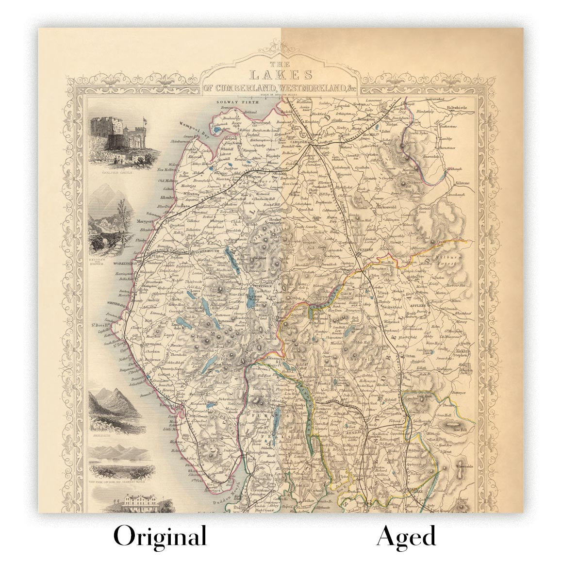
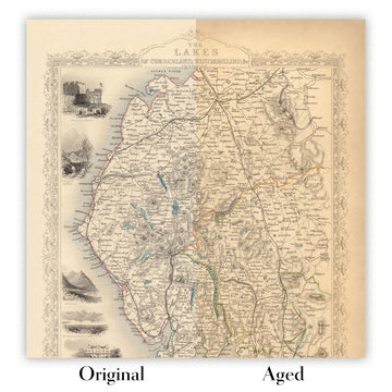
Map ageing
I have been asked hundreds of times over the years by customers if they could buy a map that looks even older.
Well, now you can, by selecting Aged before you add a map to your basket.
All the product photos you see on this page show the map in its Original form. This is what the map looks like today.
If you select Aged, I will age your map by hand, using a special and unique process developed through years of studying old maps, talking to researchers to understand the chemistry of aging paper, and of course... lots of practice!
If you're unsure, stick to the Original colour of the map. If you want something a bit darker and older looking, go for Aged.
Se non sei soddisfatto del tuo ordine per qualsiasi motivo, contattami per un rimborso senza problemi. Si prega di consultare la nostra politica di reso e rimborso per ulteriori informazioni.
Sono molto sicuro che ti piacerà la tua mappa restaurata o la stampa d'arte. Lo faccio dal 1984. Sono un venditore Etsy a 5 stelle. Ho venduto decine di migliaia di mappe e stampe d'arte e ho oltre 5.000 recensioni reali a 5 stelle.
Utilizzo un processo unico per restaurare mappe e opere d'arte che richiede molto tempo e lavoro. Trovare le mappe e le illustrazioni originali può richiedere mesi. Utilizzo tecnologia all'avanguardia e incredibilmente costosa per scannerizzare e restaurarle. Di conseguenza, garantisco che le mie mappe e stampe d'arte siano superiori alle altre - ecco perché posso offrire un rimborso senza problemi.
Quasi tutte le mie mappe e stampe d'arte sembrano fantastiche a grandi dimensioni (200 cm, 6,5 piedi+) e posso anche incorniciarle e consegnarle a te, tramite un corriere speciale per oggetti di grandi dimensioni. Contattami per discutere delle tue esigenze specifiche.
Or try searching for something!


