


Mappa Pittorica del Maryland di Ruth Taylor White, 1935: Baltimora, Annapolis, Baia di Chesapeake, Fiume Potomac, Monti Appalachi
L’offerta del Collezionista
Scegli due opere idonee e ricevi il 20% di sconto su entrambe. Scegline tre e quella al prezzo più basso è in omaggio, con un risparmio massimo del 33%.
Abbina liberamente mappe standard idonee e stampe d’arte fine art. Non è richiesto alcun codice; l’offerta viene applicata automaticamente al checkout.
Sono incluse le configurazioni standard su ordinazione. Sono esclusi formati su misura, design personalizzati e lavori su commissione.
Hai bisogno di consegne a indirizzi diversi? Contattaci prima di effettuare l’ordine.L’offerta del Collezionista
Scegli due opere idonee e ricevi il 20% di sconto su entrambe. Scegline tre e quella al prezzo più basso è in omaggio, con un risparmio massimo del 33%.
Abbina liberamente mappe standard idonee e stampe d’arte fine art. Non è richiesto alcun codice; l’offerta viene applicata automaticamente al checkout.
Sono incluse le configurazioni standard su ordinazione. Sono esclusi formati su misura, design personalizzati e lavori su commissione.
Hai bisogno di consegne a indirizzi diversi? Contattaci prima di effettuare l’ordine. Progettato a Londra Prodotto nell’UE
Progettato a Londra • Prodotto nell’UE
Progettato a Londra Prodotto nell’UE
Progettato a Londra • Prodotto nell’UE

Restaurata dalla mappa originale del 1935 e stampata in qualità museale. Leggi la storia dietro questa mappa
Choose your size
Choose your finish


(Maggiori informazioni)
Gift message & custom finish

If you want to add a gift message, or a finish (jigsaw, aluminium board, etc.) that is not available here, please request it in the "order note" when you check out.
Every order is custom made, so if you need the size adjusted slightly, or printed on an unusual material, just let us know. We've done thousands of custom orders over the years, so there's (almost) nothing we can't manage.
You can also contact us before you order, if you prefer!

- Prodotto localmente. Consegna sicura
- Nessun dazio o costo nascosto
- Serve aiuto? Chiamaci o messaggio su WhatsApp
Own a piece of history
8,000+ five-star reviews


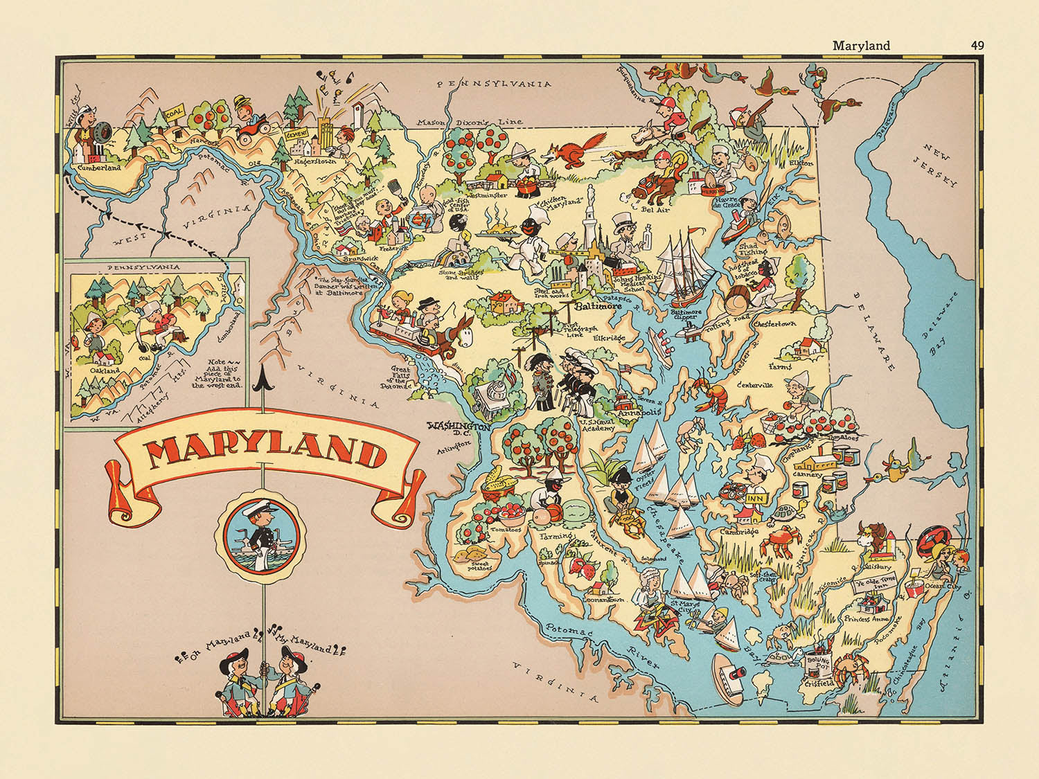
Entra nel vibrante mondo dell'America degli anni '30 con "Maryland", una mappa illustrata affascinante originariamente realizzata da Ruth Taylor White nel 1935....
Continua a leggereEntra nel vibrante mondo dell'America degli anni '30 con "Maryland", una mappa illustrata affascinante originariamente realizzata da Ruth Taylor White nel 1935. Con il suo titolo semplice ma evocativo, questa mappa è una celebrazione dell'identità unica del Maryland durante un'era trasformativa nella storia americana. Con ogni sguardo, sei invitato ad esplorare il ricco arazzo dello stato—le sue ondulate Montagne Appalache, la storica Baia di Chesapeake e il vitale Fiume Potomac—tutti resi nello stile giocoso e caratteristico di White. Le illustrazioni vivaci e la palette di colori immediatamente evocano lo spirito del tempo, catturando non solo la geografia ma anche la cultura e il carattere che definivano il Maryland.
Ruth Taylor White, una luminare nel mondo della cartografia illustrata, era rinomata per la sua abilità di mescolare arte e narrazione. Le sue mappe, spesso prodotte in collaborazione con suo marito Frank Taylor, trascendevano i semplici strumenti di navigazione, servendo invece come narrazioni visive che portavano gli stati in vita per un vasto pubblico. In "Maryland", l'approccio immaginativo di White è inconfondibile: le contee sono delineate con chiarezza audace, mentre scene di vita quotidiana, industrie locali e fauna iconica sono intrecciate nel paesaggio. Le sue distintive illustrazioni in stile cartone animato e le tonalità vivaci trasformano la mappa in un delizioso tableau, rendendola sia uno strumento educativo che un'opera d'arte.
La ricchezza tematica della mappa è immediatamente evidente nelle sue rappresentazioni del sangue vitale economico e culturale del Maryland. Illustrazioni di campi di tabacco, fattorie di pollame e barche da granchio affollate rendono omaggio al patrimonio agricolo e marittimo dello stato. La Baia di Chesapeake, resa con amorevole dettaglio, ancorano la mappa, mentre le scene di raccolta delle ostriche e di navigazione evidenziano la profonda connessione della regione con le sue vie d'acqua. La presenza di lavoratori afroamericani in contesti agricoli, sebbene riflettente della sua epoca, offre una finestra toccante nella storia sociale e del lavoro dello stato, catturando sia la vivacità che la complessità del passato del Maryland.
Oltre ai suoi motivi agricoli e marittimi, la mappa è viva con rappresentazioni fantasiose delle usanze locali, degli abiti dell'epoca e della fauna autoctona. Anatre, pesci e altre fauna sono sparse giocose in tutto, mentre la bandiera dello stato del Maryland e i bordi decorativi incorniciano la composizione con un tocco patriottico. La Linea Mason-Dixon, le Highlands Appalache e la costa atlantica sono tutte accuratamente delineate, ancorando le illustrazioni fantasiose in una geografia riconoscibile. Ogni elemento visivo, dalle montagne ondulate a ovest alle coste affollate a est, invita lo spettatore a intraprendere un viaggio attraverso i paesaggi diversificati e i confini storici del Maryland.
Città e paesi sono pensati con cura attraverso la mappa, dalle storiche strade di Annapolis alla metropoli affollata di Baltimora, e alle affascinanti comunità di Frederick, Hagerstown e Cumberland. Ogni insediamento è rappresentato con un occhio sia per l'accuratezza che per il carattere, riflettendo la loro importanza nel tessuto sociale ed economico dello stato. Questa mappa è più di un pezzo decorativo—è un documento storico vibrante, una testimonianza del genio artistico di Ruth Taylor White, e una finestra unica sul Maryland di un tempo passato. Per collezionisti, storici o chiunque abbia una passione per il patrimonio americano, "Maryland" è un artefatto straordinario che incanta ed educa in egual misura.
Città e paesi su questa mappa
- Baltimora
- Annapolis
- Frederick
- Hagerstown
- Cumberland
- Salisbury
- Cambridge
- Easton
- Rockville
- Westminster
- Elkton
- La Plata
- Chestertown
Caratteristiche e monumenti notevoli
- La Baia di Chesapeake è illustrata e etichettata in modo prominente.
- Il fiume Potomac è rappresentato lungo il confine meridionale dello stato.
- Oceano Atlantico è mostrato a est del Maryland.
- La linea Mason-Dixon è contrassegnata, indicando il confine settentrionale con la Pennsylvania.
- Le Montagne Appalache sono illustrate nella parte occidentale dello stato.
- Illustrazioni di attività agricole, come la coltivazione del tabacco e l'allevamento di pollame, sono visibili.
- Rappresentazioni di pesca e raccolta di ostriche, che riflettono l'industria ittica del Maryland.
- Immagini di lavoratori afroamericani in contesti agricoli, che riflettono le demografie e le pratiche lavorative dell'epoca.
- Illustrazioni di attività di vela e navigazione nella Baia di Chesapeake.
- Rappresentazioni cartoonistiche della fauna locale, come anatre e pesci.
- La mappa include disegni fantasiosi di persone in abiti d'epoca, impegnate in varie attività.
- I contea dello stato sono delineati e etichettati.
- La bandiera del Maryland è illustrata.
- La mappa presenta bordi decorativi con ulteriori piccole illustrazioni rilevanti per la cultura e la storia del Maryland.
Contesto storico e di design
- La mappa è intitolata "Maryland."
- Creata nel 1935 da Ruth Taylor White, un'illustratrice ben nota famosa per le sue mappe pittoriche colorate e fantasiose.
- La mappa fa parte di una serie più ampia di atlanti pittorici o cartoon divertenti e fantasiosi degli Stati Uniti, popolari all'inizio del XX secolo.
- Pubblicata durante un periodo in cui le mappe pittoriche venivano utilizzate sia per educare che per divertire, spesso riflettendo la cultura e gli stereotipi dell'epoca.
- Lo stile artistico è cartoonistico e giocoso, con colori ricchi e caratteristiche esagerate, tipiche del lavoro di Ruth Taylor White.
- Le illustrazioni servono sia come decorazione che come commento leggero, fornendo un'idea di come il Maryland fosse percepito negli anni '30.
- La mappa è storicamente significativa come esempio di come gli stati venivano rappresentati nella cultura popolare all'inizio del XX secolo.
- Ruth Taylor White collaborava spesso con suo marito, Frank Taylor, su questi atlanti pittorici, che venivano ampiamente distribuiti in riviste e libri.
- La mappa fornisce un record visivo unico dell'identità e della reputazione del Maryland durante gli anni '30.
Si prega di controllare attentamente le immagini per assicurarsi che una specifica città o luogo sia mostrato su questa mappa. Puoi anche contattarci e chiedere di controllare la mappa per te.
Questa mappa appare fantastica in ogni dimensione, ma consiglio sempre di optare per una dimensione più grande se hai spazio. In questo modo puoi facilmente distinguere tutti i dettagli.
Questa mappa appare incredibile in dimensioni fino a 50in (125cm). Se stai cercando una mappa più grande, per favore contattaci.
Il modello nelle immagini dell'elenco tiene la versione di questa mappa di 18x24in (45x60cm).
La quinta immagine dell'elenco mostra un esempio del mio servizio di personalizzazione della mappa.
Se stai cercando qualcosa di leggermente diverso, dai un'occhiata alla mia collezione delle migliori vecchie mappe per vedere se qualcosa attira la tua attenzione.
Per favore contattami per verificare se una certa posizione, un punto di riferimento o una caratteristica è mostrata su questa mappa.
Questo sarebbe un meraviglioso regalo per un compleanno, Natale, Festa del Papà, addio al lavoro, anniversario o inaugurazione della casa per qualcuno delle aree coperte da questa mappa.
Questa mappa è disponibile come stampa giclée su carta opaca archivistica senza acidi, oppure puoi acquistarla incorniciata. La cornice è una semplice cornice nera che si adatta alla maggior parte degli stili. Ti preghiamo di contattarci se desideri un colore o un materiale di cornice diverso. Le mie cornici sono dotate di un vetro acrilico super chiaro di qualità museale (perspex/acrylite), che è significativamente meno riflettente del vetro, più sicuro e arriverà sempre in condizioni perfette.
This map is also available as a float framed canvas, sometimes known as a shadow gap framed canvas or canvas floater. The map is printed on artist's cotton canvas and then stretched over a handmade box frame. We then "float" the canvas inside a wooden frame, which is available in a range of colours (black, dark brown, oak, antique gold and white). This is a wonderful way to present a map without glazing in front. See some examples of float framed canvas maps and explore the differences between my different finishes.
For something truly unique, this map is also available in "Unique 3D", our trademarked process that dramatically transforms the map so that it has a wonderful sense of depth. We combine the original map with detailed topography and elevation data, so that mountains and the terrain really "pop". For more info and examples of 3D maps, check my Unique 3D page.
Entra nel vibrante mondo dell'America degli anni '30 con "Maryland", una mappa illustrata affascinante originariamente realizzata da Ruth Taylor White nel 1935. Con il suo titolo semplice ma evocativo, questa mappa è una celebrazione dell'identità unica del Maryland durante un'era trasformativa nella storia americana. Con ogni sguardo, sei invitato ad esplorare il ricco arazzo dello stato—le sue ondulate Montagne Appalache, la storica Baia di Chesapeake e il vitale Fiume Potomac—tutti resi nello stile giocoso e caratteristico di White. Le illustrazioni vivaci e la palette di colori immediatamente evocano lo spirito del tempo, catturando non solo la geografia ma anche la cultura e il carattere che definivano il Maryland.
Ruth Taylor White, una luminare nel mondo della cartografia illustrata, era rinomata per la sua abilità di mescolare arte e narrazione. Le sue mappe, spesso prodotte in collaborazione con suo marito Frank Taylor, trascendevano i semplici strumenti di navigazione, servendo invece come narrazioni visive che portavano gli stati in vita per un vasto pubblico. In "Maryland", l'approccio immaginativo di White è inconfondibile: le contee sono delineate con chiarezza audace, mentre scene di vita quotidiana, industrie locali e fauna iconica sono intrecciate nel paesaggio. Le sue distintive illustrazioni in stile cartone animato e le tonalità vivaci trasformano la mappa in un delizioso tableau, rendendola sia uno strumento educativo che un'opera d'arte.
La ricchezza tematica della mappa è immediatamente evidente nelle sue rappresentazioni del sangue vitale economico e culturale del Maryland. Illustrazioni di campi di tabacco, fattorie di pollame e barche da granchio affollate rendono omaggio al patrimonio agricolo e marittimo dello stato. La Baia di Chesapeake, resa con amorevole dettaglio, ancorano la mappa, mentre le scene di raccolta delle ostriche e di navigazione evidenziano la profonda connessione della regione con le sue vie d'acqua. La presenza di lavoratori afroamericani in contesti agricoli, sebbene riflettente della sua epoca, offre una finestra toccante nella storia sociale e del lavoro dello stato, catturando sia la vivacità che la complessità del passato del Maryland.
Oltre ai suoi motivi agricoli e marittimi, la mappa è viva con rappresentazioni fantasiose delle usanze locali, degli abiti dell'epoca e della fauna autoctona. Anatre, pesci e altre fauna sono sparse giocose in tutto, mentre la bandiera dello stato del Maryland e i bordi decorativi incorniciano la composizione con un tocco patriottico. La Linea Mason-Dixon, le Highlands Appalache e la costa atlantica sono tutte accuratamente delineate, ancorando le illustrazioni fantasiose in una geografia riconoscibile. Ogni elemento visivo, dalle montagne ondulate a ovest alle coste affollate a est, invita lo spettatore a intraprendere un viaggio attraverso i paesaggi diversificati e i confini storici del Maryland.
Città e paesi sono pensati con cura attraverso la mappa, dalle storiche strade di Annapolis alla metropoli affollata di Baltimora, e alle affascinanti comunità di Frederick, Hagerstown e Cumberland. Ogni insediamento è rappresentato con un occhio sia per l'accuratezza che per il carattere, riflettendo la loro importanza nel tessuto sociale ed economico dello stato. Questa mappa è più di un pezzo decorativo—è un documento storico vibrante, una testimonianza del genio artistico di Ruth Taylor White, e una finestra unica sul Maryland di un tempo passato. Per collezionisti, storici o chiunque abbia una passione per il patrimonio americano, "Maryland" è un artefatto straordinario che incanta ed educa in egual misura.
Città e paesi su questa mappa
- Baltimora
- Annapolis
- Frederick
- Hagerstown
- Cumberland
- Salisbury
- Cambridge
- Easton
- Rockville
- Westminster
- Elkton
- La Plata
- Chestertown
Caratteristiche e monumenti notevoli
- La Baia di Chesapeake è illustrata e etichettata in modo prominente.
- Il fiume Potomac è rappresentato lungo il confine meridionale dello stato.
- Oceano Atlantico è mostrato a est del Maryland.
- La linea Mason-Dixon è contrassegnata, indicando il confine settentrionale con la Pennsylvania.
- Le Montagne Appalache sono illustrate nella parte occidentale dello stato.
- Illustrazioni di attività agricole, come la coltivazione del tabacco e l'allevamento di pollame, sono visibili.
- Rappresentazioni di pesca e raccolta di ostriche, che riflettono l'industria ittica del Maryland.
- Immagini di lavoratori afroamericani in contesti agricoli, che riflettono le demografie e le pratiche lavorative dell'epoca.
- Illustrazioni di attività di vela e navigazione nella Baia di Chesapeake.
- Rappresentazioni cartoonistiche della fauna locale, come anatre e pesci.
- La mappa include disegni fantasiosi di persone in abiti d'epoca, impegnate in varie attività.
- I contea dello stato sono delineati e etichettati.
- La bandiera del Maryland è illustrata.
- La mappa presenta bordi decorativi con ulteriori piccole illustrazioni rilevanti per la cultura e la storia del Maryland.
Contesto storico e di design
- La mappa è intitolata "Maryland."
- Creata nel 1935 da Ruth Taylor White, un'illustratrice ben nota famosa per le sue mappe pittoriche colorate e fantasiose.
- La mappa fa parte di una serie più ampia di atlanti pittorici o cartoon divertenti e fantasiosi degli Stati Uniti, popolari all'inizio del XX secolo.
- Pubblicata durante un periodo in cui le mappe pittoriche venivano utilizzate sia per educare che per divertire, spesso riflettendo la cultura e gli stereotipi dell'epoca.
- Lo stile artistico è cartoonistico e giocoso, con colori ricchi e caratteristiche esagerate, tipiche del lavoro di Ruth Taylor White.
- Le illustrazioni servono sia come decorazione che come commento leggero, fornendo un'idea di come il Maryland fosse percepito negli anni '30.
- La mappa è storicamente significativa come esempio di come gli stati venivano rappresentati nella cultura popolare all'inizio del XX secolo.
- Ruth Taylor White collaborava spesso con suo marito, Frank Taylor, su questi atlanti pittorici, che venivano ampiamente distribuiti in riviste e libri.
- La mappa fornisce un record visivo unico dell'identità e della reputazione del Maryland durante gli anni '30.
Si prega di controllare attentamente le immagini per assicurarsi che una specifica città o luogo sia mostrato su questa mappa. Puoi anche contattarci e chiedere di controllare la mappa per te.
Questa mappa appare fantastica in ogni dimensione, ma consiglio sempre di optare per una dimensione più grande se hai spazio. In questo modo puoi facilmente distinguere tutti i dettagli.
Questa mappa appare incredibile in dimensioni fino a 50in (125cm). Se stai cercando una mappa più grande, per favore contattaci.
Il modello nelle immagini dell'elenco tiene la versione di questa mappa di 18x24in (45x60cm).
La quinta immagine dell'elenco mostra un esempio del mio servizio di personalizzazione della mappa.
Se stai cercando qualcosa di leggermente diverso, dai un'occhiata alla mia collezione delle migliori vecchie mappe per vedere se qualcosa attira la tua attenzione.
Per favore contattami per verificare se una certa posizione, un punto di riferimento o una caratteristica è mostrata su questa mappa.
Questo sarebbe un meraviglioso regalo per un compleanno, Natale, Festa del Papà, addio al lavoro, anniversario o inaugurazione della casa per qualcuno delle aree coperte da questa mappa.
Questa mappa è disponibile come stampa giclée su carta opaca archivistica senza acidi, oppure puoi acquistarla incorniciata. La cornice è una semplice cornice nera che si adatta alla maggior parte degli stili. Ti preghiamo di contattarci se desideri un colore o un materiale di cornice diverso. Le mie cornici sono dotate di un vetro acrilico super chiaro di qualità museale (perspex/acrylite), che è significativamente meno riflettente del vetro, più sicuro e arriverà sempre in condizioni perfette.
This map is also available as a float framed canvas, sometimes known as a shadow gap framed canvas or canvas floater. The map is printed on artist's cotton canvas and then stretched over a handmade box frame. We then "float" the canvas inside a wooden frame, which is available in a range of colours (black, dark brown, oak, antique gold and white). This is a wonderful way to present a map without glazing in front. See some examples of float framed canvas maps and explore the differences between my different finishes.
For something truly unique, this map is also available in "Unique 3D", our trademarked process that dramatically transforms the map so that it has a wonderful sense of depth. We combine the original map with detailed topography and elevation data, so that mountains and the terrain really "pop". For more info and examples of 3D maps, check my Unique 3D page.
Many of our maps and art prints are chosen as thoughtful gifts for homes, offices, studies and meaningful places.
Choose a framed option for the easiest ready-to-hang gift, or choose an unframed print if the recipient may prefer to select their own frame.
We make orders locally in 23 countries around the world, so gifts can often be produced close to the recipient. This helps them arrive faster, travel more safely, and avoid customs or import duty surprises.
- We can deliver directly to the recipient
- Framed pieces arrive ready to hang
- Unframed prints are carefully packed in a strong protective tube
- Almost every order is made locally, for faster, safer gifting
- 90-day returns give the recipient time to decide
If you are not sure what to choose, please contact us. We can help you pick the right map, size, finish or delivery option.
Most orders are made locally and delivered in around 2–3 working days, depending on the product, size and destination.
We print and frame maps and artwork in 23 countries around the world, so your order is usually made close to you or your recipient. That means faster delivery, less time in transit, and no customs or import duty surprises.
Personalised and customised pieces usually take an extra 1–2 working days, because we prepare your design and send it to you for approval before printing.
Very large framed orders can take a little longer, as they need extra care in production and delivery.
Every order is carefully packaged: unframed prints are sent in a strong protective tube, while framed pieces are securely packed with protective materials around the frame.
If you need your order by a particular date, please contact us before ordering. We’ll check the best production route and delivery option for your location.
Express delivery is available at checkout for most countries. Next-day delivery is available in the UK, US, Singapore and the UAE.
Your order is covered by our 90-day returns policy and 10-year guarantee.
Our standard frame is a gallery-style black ash hardwood frame, with a simple, modern look. It is approximately 20mm (0.8in) wide. You can also view some lovely customer photos of framed maps and art.
We use super-clear acrylic glazing, also known as Perspex or Acrylite, instead of traditional glass. It is lighter, safer, and has lower reflectivity, giving the artwork a clearer, cleaner appearance.
Six standard frame colours are available at no extra cost: black, dark brown, dark grey, oak, white, and antique gold. Custom framing and mounting/matting is also available for customers looking for something more specific.
Most maps, art prints, and illustrations are also available as a framed canvas. We use matte cotton canvas, stretch it over a sustainably sourced wooden box frame, and then float the piece within a wooden outer frame. The finished result is beautifully presented, with no glazing between you and the artwork.
All frames are supplied ready to hang, with either string or brackets fitted to the back. Very large frames will include heavy-duty hanging plates and/or a mounting baton. If you have any questions, please get in touch.
We can also supply old maps and artwork on canvas, foam board, cotton rag, and other materials.
If you would prefer to frame your map or artwork yourself, please read our size guide before ordering.
My maps are extremely high quality reproductions of original maps.
I source original, rare maps from libraries, auction houses and private collections around the world, restore them at my London workshop, and then use specialist giclée inks and printers to create beautiful maps that look even better than the original.
My maps are printed on acid-free archival matte (not glossy) paper that feels very high quality and almost like card. In technical terms the paper weight/thickness is 10mil/200gsm. It's perfect for framing.
I print with Epson ultrachrome giclée UV fade resistant pigment inks - some of the best inks you can find.
I can also make maps on canvas, cotton rag and other exotic materials.
Learn more about The Unique Maps Co.
Map personalisation
If you're looking for the perfect anniversary or housewarming gift, I can personalise your map to make it truly unique. For example, I can add a short message, or highlight an important location, or add your family's coat of arms.
The options are almost infinite. Please see my map personalisation page for some wonderful examples of what's possible.
To order a personalised map, select "personalise your map" before adding it to your basket.
Get in touch if you're looking for more complex customisations and personalisations.
Map ageing
I have been asked hundreds of times over the years by customers if they could buy a map that looks even older.
Well, now you can, by selecting Aged before you add a map to your basket.
All the product photos you see on this page show the map in its Original form. This is what the map looks like today.
If you select Aged, I will age your map by hand, using a special and unique process developed through years of studying old maps, talking to researchers to understand the chemistry of aging paper, and of course... lots of practice!
If you're unsure, stick to the Original colour of the map. If you want something a bit darker and older looking, go for Aged.
Se non sei soddisfatto del tuo ordine per qualsiasi motivo, contattami per un rimborso senza problemi. Si prega di consultare la nostra politica di reso e rimborso per ulteriori informazioni.
Sono molto sicuro che ti piacerà la tua mappa restaurata o la stampa d'arte. Lo faccio dal 1984. Sono un venditore Etsy a 5 stelle. Ho venduto decine di migliaia di mappe e stampe d'arte e ho oltre 5.000 recensioni reali a 5 stelle.
Utilizzo un processo unico per restaurare mappe e opere d'arte che richiede molto tempo e lavoro. Trovare le mappe e le illustrazioni originali può richiedere mesi. Utilizzo tecnologia all'avanguardia e incredibilmente costosa per scannerizzare e restaurarle. Di conseguenza, garantisco che le mie mappe e stampe d'arte siano superiori alle altre - ecco perché posso offrire un rimborso senza problemi.
Quasi tutte le mie mappe e stampe d'arte sembrano fantastiche a grandi dimensioni (200 cm, 6,5 piedi+) e posso anche incorniciarle e consegnarle a te, tramite un corriere speciale per oggetti di grandi dimensioni. Contattami per discutere delle tue esigenze specifiche.
Or try searching for something!


