

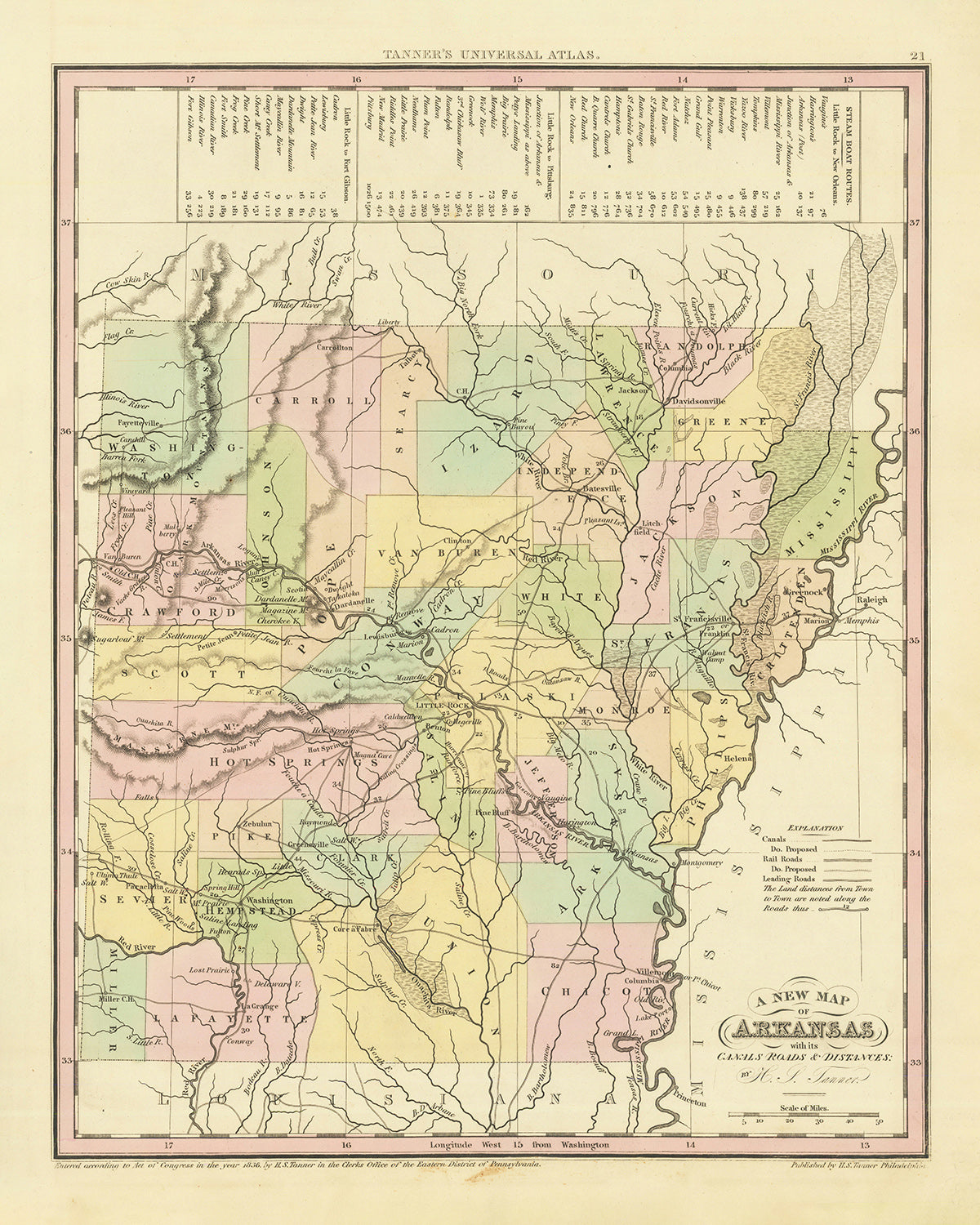


Mappa Antica dell'Arkansas di H. S. Tanner, 1836: Little Rock, Fort Smith, Pine Bluff, Batesville, Washington, Strade, Ferrovia, Canali
L’offerta del Collezionista
Scegli due opere idonee e ricevi il 20% di sconto su entrambe. Scegline tre e quella al prezzo più basso è in omaggio, con un risparmio massimo del 33%.
Abbina liberamente mappe standard idonee e stampe d’arte fine art. Non è richiesto alcun codice; l’offerta viene applicata automaticamente al checkout.
Sono incluse le configurazioni standard su ordinazione. Sono esclusi formati su misura, design personalizzati e lavori su commissione.
Hai bisogno di consegne a indirizzi diversi? Contattaci prima di effettuare l’ordine.L’offerta del Collezionista
Scegli due opere idonee e ricevi il 20% di sconto su entrambe. Scegline tre e quella al prezzo più basso è in omaggio, con un risparmio massimo del 33%.
Abbina liberamente mappe standard idonee e stampe d’arte fine art. Non è richiesto alcun codice; l’offerta viene applicata automaticamente al checkout.
Sono incluse le configurazioni standard su ordinazione. Sono esclusi formati su misura, design personalizzati e lavori su commissione.
Hai bisogno di consegne a indirizzi diversi? Contattaci prima di effettuare l’ordine. Progettato a Londra Prodotto nell’UE
Progettato a Londra • Prodotto nell’UE
Progettato a Londra Prodotto nell’UE
Progettato a Londra • Prodotto nell’UE

Restaurata dalla mappa originale del 1836 e stampata in qualità museale. Leggi la storia dietro questa mappa
Choose your size
Choose your finish


(Maggiori informazioni)
Gift message & custom finish

If you want to add a gift message, or a finish (jigsaw, aluminium board, etc.) that is not available here, please request it in the "order note" when you check out.
Every order is custom made, so if you need the size adjusted slightly, or printed on an unusual material, just let us know. We've done thousands of custom orders over the years, so there's (almost) nothing we can't manage.
You can also contact us before you order, if you prefer!

- Prodotto localmente. Consegna sicura
- Nessun dazio o costo nascosto
- Serve aiuto? Chiamaci o messaggio su WhatsApp
Own a piece of history
8,000+ five-star reviews


Immergiti nel passato con l’accurata realizzazione della "Old Map of Arkansas" del rinomato cartografo H. S. Tanner, pubblicata nel 1836. Questo straordinario...
Continua a leggereImmergiti nel passato con l’accurata realizzazione della "Old Map of Arkansas" del rinomato cartografo H. S. Tanner, pubblicata nel 1836. Questo straordinario reperto del tempo offre un dettagliato quadro dell’Arkansas dei primi del XIX secolo, raffigurando non solo gli insediamenti e la geografia, ma anche l’intricata rete di canali e strade che fungevano da linfa vitale per i collegamenti e il commercio. Questo prezioso pezzo non è solo una mappa, ma una narrazione completa dell’epoca, che riflette le distanze tra città e colonie di fondamentale importanza nell’era prerailway.
La mappa di H. S. Tanner, oltre alla sua precisa rappresentazione dell’Arkansas delle origini, possiede un fascino storico ed estetico che attrae collezionisti, appassionati di storia e amanti dell’arte d’epoca. La mappa illustra un vivace quadro dello Stato prima del suo sviluppo industriale, con gli insediamenti che avrebbero poi plasmato i suoi scenari culturali, economici e politici. La meticolosa attenzione ai dettagli del cartografo e la rappresentazione accurata dell’epoca rendono questo pezzo un reperto inestimabile che cattura lo spirito dell’Arkansas del 1836.
Insediamenti di rilievo
- Little Rock (1821): oggi capitale dello Stato, era un centro di scambi e trasporti grazie alla sua posizione strategica lungo il fiume Arkansas.
- Fort Smith (1817): fondato come avamposto militare di frontiera occidentale, svolse un ruolo vitale nell’espansione verso ovest degli Stati Uniti.
- Pine Bluff (1832): adagiata lungo il fiume Arkansas, fu un importante centro di trasporti e commerci nel XIX secolo.
- Batesville (1810): una delle città più antiche, servì come importante porto lungo il fiume White.
- Washington (1824): sito cruciale durante la Guerra civile, servì da capitale dell’Arkansas dopo la cattura di Little Rock da parte delle truppe dell’Unione.
- Fayetteville (1828): famosa per il suo paesaggio pittoresco, questa città ospitò in seguito l’Università dell’Arkansas.
- Helena (1833): questa città fu un deposito vitale per le truppe dell’Unione durante la Guerra civile.
- Van Buren (1831): intitolata a Martin Van Buren, vanta una ricca storia radicata nei primi anni di statualità dell’Arkansas.
- Benton (1833): la città deriva il suo nome da Thomas Hart Benton, un senatore che svolse un ruolo cruciale nell’advocacy per la statualità dell’Arkansas.
- Camden (1824): nota per il prospero commercio del cotone, Camden fiorì come porto fluviale.
- Dover (1821): situata nelle splendide montagne Ozark, questa città offriva un importante passaggio nord-sud.
- Pocahontas (1835): situata vicino al fiume Black, fungeva da centro per il commercio agricolo e del legname.
- Powhatan (1811): un tempo capoluogo della contea di Lawrence County, era un importante porto fluviale sul fiume Black.
- Jacksonport (1831): questa città prosperò come tappa per i battelli a vapore alla confluenza dei fiumi White e Black.
- Mammoth Spring (1836): così chiamata per la grande sorgente della zona, era una risorsa fondamentale per i coloni.
- Cherokee Bay (1820s): questo insediamento era un importante luogo di raccolta per i Cherokee prima del Trail of Tears.
- Cadron (1818): questa città era una tappa significativa lungo il percorso della Butterfield Overland Mail.
- Arkadelphia (1836): nota per le sue industrie del legname e del cotone, questa città era un centro commerciale.
- Napoleon (1829): un tempo fiorente porto fluviale, fu infine abbandonata a causa delle frequenti inondazioni.
- Davidsonville (1815): sede del primo ufficio postale e del primo land office dell’Arkansas, questa città svolse un ruolo chiave nello sviluppo della regione.
- Evening Shade (1810s): Chiamata così per le sue serate insolitamente ombreggiate, questa città era una tappa per i viaggiatori diretti verso ovest.
- Monticello (1836): Questa città divenne il capoluogo della contea di Drew appena un anno dopo la sua fondazione.
- New Gascony (1797): Conosciuto come il più antico insediamento permanente europeo in Arkansas, era un importante centro del commercio delle pellicce.
- Cotton Plant (1820s): Come suggerisce il nome, questa città era un centro della coltivazione del cotone.
- Augusta (1820): Situata lungo il White River, divenne un importante snodo dei trasporti.
- Clarendon (1824): Situata alla confluenza dei fiumi Cache e White, questa città era un centro essenziale per i trasporti e il commercio.
- Hamburg (1821): Questa città prosperò come centro del legname e dell'agricoltura.
- Princeton (1833): Chiamata così in onore dell'eroe della Guerra d'Indipendenza, Princeton era una tappa importante per viaggiatori e commercianti.
- Lewisburg (1832): Questa città era un sito chiave per il commercio, in particolare di cotone e legname.
- Ozark (1820s): Chiamato così in riferimento alla regione degli Ozark, questo insediamento offriva un accesso alla fertile valle del fiume Arkansas.
La mappa mette inoltre in risalto diverse caratteristiche geografiche e confini che oggi sono note attrazioni turistiche, come i maestosi fiumi Arkansas e Mississippi, le lussureggianti e panoramiche montagne Ozark e Ouachita, e il Territorio Indiano designato a ovest, che in seguito divenne l'attuale Oklahoma.
Per quanto riguarda gli eventi storici, la mappa racchiude un periodo di trasformazioni significative: la creazione del Territorio dell'Arkansas nel 1819, l'ammissione dello stato nell'Unione come 25º stato nel 1836 e il tragico Sentiero delle Lacrime (1838-1839), che vide migliaia di nativi americani trasferiti con la forza attraverso l'Arkansas. Queste tappe storiche amplificano ulteriormente il significato di questa mappa, rendendola non solo un'antichità ma una cronaca visiva del passato.
Si prega di controllare attentamente le immagini per assicurarsi che una determinata città o località sia raffigurata su questa mappa. Potete anche contattarci e chiederci di verificare la mappa per voi.
Questa mappa è splendida in tutti i formati: 12x16in (30.5x41cm), 16x20in (40.5x51cm), 18x24in (45.5x61cm), 24x30in (61x76cm), 32x40in (81.5x102cm), 40x50in (102x127cm), 48x60in (122x153cm) e 56x70in (142x178cm), ma risulta ancora più bella se stampata in grande formato.
Posso realizzare splendide stampe di grandi dimensioni di questa mappa fino a 100in (254cm). Contattatemi se cercate formati più grandi, personalizzati o diverse opzioni di cornice.
La modella nelle immagini dell'inserzione tiene in mano la versione 16x20in (40.5x51cm) di questa mappa.
La quinta immagine dell'inserzione mostra un esempio del mio servizio di personalizzazione delle mappe.
Se state cercando qualcosa di leggermente diverso, date un'occhiata alla mia collezione principale di mappe degli USA e del Nord America.
Vi prego di contattarmi per verificare se una certa località, punto di riferimento o elemento è presente su questa mappa.
Sarebbe un meraviglioso regalo di compleanno, di Natale, per la Festa del Papà, per un congedo dal lavoro, per un anniversario o per un nuovo inizio casa per qualcuno proveniente dalle aree coperte da questa mappa.
Questa mappa è disponibile come stampa giclée su carta opaca d’archivio senza acidi, oppure può essere acquistata già incorniciata. La cornice è una bella e semplice cornice nera, adatta alla maggior parte degli stili. Non esitate a contattarci se desiderate un colore o un materiale diverso per la cornice. Le mie cornici sono dotate di vetro protettivo in acrilico di qualità museale super trasparente (perspex/acrylite), decisamente meno riflettente del vetro, più sicuro e destinato ad arrivare sempre in perfette condizioni.
This map is also available as a float framed canvas, sometimes known as a shadow gap framed canvas or canvas floater. The map is printed on artist's cotton canvas and then stretched over a handmade box frame. We then "float" the canvas inside a wooden frame, which is available in a range of colours (black, dark brown, oak, antique gold and white). This is a wonderful way to present a map without glazing in front. See some examples of float framed canvas maps and explore the differences between my different finishes.
For something truly unique, this map is also available in "Unique 3D", our trademarked process that dramatically transforms the map so that it has a wonderful sense of depth. We combine the original map with detailed topography and elevation data, so that mountains and the terrain really "pop". For more info and examples of 3D maps, check my Unique 3D page.
Immergiti nel passato con l’accurata realizzazione della "Old Map of Arkansas" del rinomato cartografo H. S. Tanner, pubblicata nel 1836. Questo straordinario reperto del tempo offre un dettagliato quadro dell’Arkansas dei primi del XIX secolo, raffigurando non solo gli insediamenti e la geografia, ma anche l’intricata rete di canali e strade che fungevano da linfa vitale per i collegamenti e il commercio. Questo prezioso pezzo non è solo una mappa, ma una narrazione completa dell’epoca, che riflette le distanze tra città e colonie di fondamentale importanza nell’era prerailway.
La mappa di H. S. Tanner, oltre alla sua precisa rappresentazione dell’Arkansas delle origini, possiede un fascino storico ed estetico che attrae collezionisti, appassionati di storia e amanti dell’arte d’epoca. La mappa illustra un vivace quadro dello Stato prima del suo sviluppo industriale, con gli insediamenti che avrebbero poi plasmato i suoi scenari culturali, economici e politici. La meticolosa attenzione ai dettagli del cartografo e la rappresentazione accurata dell’epoca rendono questo pezzo un reperto inestimabile che cattura lo spirito dell’Arkansas del 1836.
Insediamenti di rilievo
- Little Rock (1821): oggi capitale dello Stato, era un centro di scambi e trasporti grazie alla sua posizione strategica lungo il fiume Arkansas.
- Fort Smith (1817): fondato come avamposto militare di frontiera occidentale, svolse un ruolo vitale nell’espansione verso ovest degli Stati Uniti.
- Pine Bluff (1832): adagiata lungo il fiume Arkansas, fu un importante centro di trasporti e commerci nel XIX secolo.
- Batesville (1810): una delle città più antiche, servì come importante porto lungo il fiume White.
- Washington (1824): sito cruciale durante la Guerra civile, servì da capitale dell’Arkansas dopo la cattura di Little Rock da parte delle truppe dell’Unione.
- Fayetteville (1828): famosa per il suo paesaggio pittoresco, questa città ospitò in seguito l’Università dell’Arkansas.
- Helena (1833): questa città fu un deposito vitale per le truppe dell’Unione durante la Guerra civile.
- Van Buren (1831): intitolata a Martin Van Buren, vanta una ricca storia radicata nei primi anni di statualità dell’Arkansas.
- Benton (1833): la città deriva il suo nome da Thomas Hart Benton, un senatore che svolse un ruolo cruciale nell’advocacy per la statualità dell’Arkansas.
- Camden (1824): nota per il prospero commercio del cotone, Camden fiorì come porto fluviale.
- Dover (1821): situata nelle splendide montagne Ozark, questa città offriva un importante passaggio nord-sud.
- Pocahontas (1835): situata vicino al fiume Black, fungeva da centro per il commercio agricolo e del legname.
- Powhatan (1811): un tempo capoluogo della contea di Lawrence County, era un importante porto fluviale sul fiume Black.
- Jacksonport (1831): questa città prosperò come tappa per i battelli a vapore alla confluenza dei fiumi White e Black.
- Mammoth Spring (1836): così chiamata per la grande sorgente della zona, era una risorsa fondamentale per i coloni.
- Cherokee Bay (1820s): questo insediamento era un importante luogo di raccolta per i Cherokee prima del Trail of Tears.
- Cadron (1818): questa città era una tappa significativa lungo il percorso della Butterfield Overland Mail.
- Arkadelphia (1836): nota per le sue industrie del legname e del cotone, questa città era un centro commerciale.
- Napoleon (1829): un tempo fiorente porto fluviale, fu infine abbandonata a causa delle frequenti inondazioni.
- Davidsonville (1815): sede del primo ufficio postale e del primo land office dell’Arkansas, questa città svolse un ruolo chiave nello sviluppo della regione.
- Evening Shade (1810s): Chiamata così per le sue serate insolitamente ombreggiate, questa città era una tappa per i viaggiatori diretti verso ovest.
- Monticello (1836): Questa città divenne il capoluogo della contea di Drew appena un anno dopo la sua fondazione.
- New Gascony (1797): Conosciuto come il più antico insediamento permanente europeo in Arkansas, era un importante centro del commercio delle pellicce.
- Cotton Plant (1820s): Come suggerisce il nome, questa città era un centro della coltivazione del cotone.
- Augusta (1820): Situata lungo il White River, divenne un importante snodo dei trasporti.
- Clarendon (1824): Situata alla confluenza dei fiumi Cache e White, questa città era un centro essenziale per i trasporti e il commercio.
- Hamburg (1821): Questa città prosperò come centro del legname e dell'agricoltura.
- Princeton (1833): Chiamata così in onore dell'eroe della Guerra d'Indipendenza, Princeton era una tappa importante per viaggiatori e commercianti.
- Lewisburg (1832): Questa città era un sito chiave per il commercio, in particolare di cotone e legname.
- Ozark (1820s): Chiamato così in riferimento alla regione degli Ozark, questo insediamento offriva un accesso alla fertile valle del fiume Arkansas.
La mappa mette inoltre in risalto diverse caratteristiche geografiche e confini che oggi sono note attrazioni turistiche, come i maestosi fiumi Arkansas e Mississippi, le lussureggianti e panoramiche montagne Ozark e Ouachita, e il Territorio Indiano designato a ovest, che in seguito divenne l'attuale Oklahoma.
Per quanto riguarda gli eventi storici, la mappa racchiude un periodo di trasformazioni significative: la creazione del Territorio dell'Arkansas nel 1819, l'ammissione dello stato nell'Unione come 25º stato nel 1836 e il tragico Sentiero delle Lacrime (1838-1839), che vide migliaia di nativi americani trasferiti con la forza attraverso l'Arkansas. Queste tappe storiche amplificano ulteriormente il significato di questa mappa, rendendola non solo un'antichità ma una cronaca visiva del passato.
Si prega di controllare attentamente le immagini per assicurarsi che una determinata città o località sia raffigurata su questa mappa. Potete anche contattarci e chiederci di verificare la mappa per voi.
Questa mappa è splendida in tutti i formati: 12x16in (30.5x41cm), 16x20in (40.5x51cm), 18x24in (45.5x61cm), 24x30in (61x76cm), 32x40in (81.5x102cm), 40x50in (102x127cm), 48x60in (122x153cm) e 56x70in (142x178cm), ma risulta ancora più bella se stampata in grande formato.
Posso realizzare splendide stampe di grandi dimensioni di questa mappa fino a 100in (254cm). Contattatemi se cercate formati più grandi, personalizzati o diverse opzioni di cornice.
La modella nelle immagini dell'inserzione tiene in mano la versione 16x20in (40.5x51cm) di questa mappa.
La quinta immagine dell'inserzione mostra un esempio del mio servizio di personalizzazione delle mappe.
Se state cercando qualcosa di leggermente diverso, date un'occhiata alla mia collezione principale di mappe degli USA e del Nord America.
Vi prego di contattarmi per verificare se una certa località, punto di riferimento o elemento è presente su questa mappa.
Sarebbe un meraviglioso regalo di compleanno, di Natale, per la Festa del Papà, per un congedo dal lavoro, per un anniversario o per un nuovo inizio casa per qualcuno proveniente dalle aree coperte da questa mappa.
Questa mappa è disponibile come stampa giclée su carta opaca d’archivio senza acidi, oppure può essere acquistata già incorniciata. La cornice è una bella e semplice cornice nera, adatta alla maggior parte degli stili. Non esitate a contattarci se desiderate un colore o un materiale diverso per la cornice. Le mie cornici sono dotate di vetro protettivo in acrilico di qualità museale super trasparente (perspex/acrylite), decisamente meno riflettente del vetro, più sicuro e destinato ad arrivare sempre in perfette condizioni.
This map is also available as a float framed canvas, sometimes known as a shadow gap framed canvas or canvas floater. The map is printed on artist's cotton canvas and then stretched over a handmade box frame. We then "float" the canvas inside a wooden frame, which is available in a range of colours (black, dark brown, oak, antique gold and white). This is a wonderful way to present a map without glazing in front. See some examples of float framed canvas maps and explore the differences between my different finishes.
For something truly unique, this map is also available in "Unique 3D", our trademarked process that dramatically transforms the map so that it has a wonderful sense of depth. We combine the original map with detailed topography and elevation data, so that mountains and the terrain really "pop". For more info and examples of 3D maps, check my Unique 3D page.
Many of our maps and art prints are chosen as thoughtful gifts for homes, offices, studies and meaningful places.
Choose a framed option for the easiest ready-to-hang gift, or choose an unframed print if the recipient may prefer to select their own frame.
We make orders locally in 23 countries around the world, so gifts can often be produced close to the recipient. This helps them arrive faster, travel more safely, and avoid customs or import duty surprises.
- We can deliver directly to the recipient
- Framed pieces arrive ready to hang
- Unframed prints are carefully packed in a strong protective tube
- Almost every order is made locally, for faster, safer gifting
- 90-day returns give the recipient time to decide
If you are not sure what to choose, please contact us. We can help you pick the right map, size, finish or delivery option.
Most orders are made locally and delivered in around 2–3 working days, depending on the product, size and destination.
We print and frame maps and artwork in 23 countries around the world, so your order is usually made close to you or your recipient. That means faster delivery, less time in transit, and no customs or import duty surprises.
Personalised and customised pieces usually take an extra 1–2 working days, because we prepare your design and send it to you for approval before printing.
Very large framed orders can take a little longer, as they need extra care in production and delivery.
Every order is carefully packaged: unframed prints are sent in a strong protective tube, while framed pieces are securely packed with protective materials around the frame.
If you need your order by a particular date, please contact us before ordering. We’ll check the best production route and delivery option for your location.
Express delivery is available at checkout for most countries. Next-day delivery is available in the UK, US, Singapore and the UAE.
Your order is covered by our 90-day returns policy and 10-year guarantee.
Our standard frame is a gallery-style black ash hardwood frame, with a simple, modern look. It is approximately 20mm (0.8in) wide. You can also view some lovely customer photos of framed maps and art.
We use super-clear acrylic glazing, also known as Perspex or Acrylite, instead of traditional glass. It is lighter, safer, and has lower reflectivity, giving the artwork a clearer, cleaner appearance.
Six standard frame colours are available at no extra cost: black, dark brown, dark grey, oak, white, and antique gold. Custom framing and mounting/matting is also available for customers looking for something more specific.
Most maps, art prints, and illustrations are also available as a framed canvas. We use matte cotton canvas, stretch it over a sustainably sourced wooden box frame, and then float the piece within a wooden outer frame. The finished result is beautifully presented, with no glazing between you and the artwork.
All frames are supplied ready to hang, with either string or brackets fitted to the back. Very large frames will include heavy-duty hanging plates and/or a mounting baton. If you have any questions, please get in touch.
We can also supply old maps and artwork on canvas, foam board, cotton rag, and other materials.
If you would prefer to frame your map or artwork yourself, please read our size guide before ordering.
My maps are extremely high quality reproductions of original maps.
I source original, rare maps from libraries, auction houses and private collections around the world, restore them at my London workshop, and then use specialist giclée inks and printers to create beautiful maps that look even better than the original.
My maps are printed on acid-free archival matte (not glossy) paper that feels very high quality and almost like card. In technical terms the paper weight/thickness is 10mil/200gsm. It's perfect for framing.
I print with Epson ultrachrome giclée UV fade resistant pigment inks - some of the best inks you can find.
I can also make maps on canvas, cotton rag and other exotic materials.
Learn more about The Unique Maps Co.
Map personalisation
If you're looking for the perfect anniversary or housewarming gift, I can personalise your map to make it truly unique. For example, I can add a short message, or highlight an important location, or add your family's coat of arms.
The options are almost infinite. Please see my map personalisation page for some wonderful examples of what's possible.
To order a personalised map, select "personalise your map" before adding it to your basket.
Get in touch if you're looking for more complex customisations and personalisations.
Map ageing
I have been asked hundreds of times over the years by customers if they could buy a map that looks even older.
Well, now you can, by selecting Aged before you add a map to your basket.
All the product photos you see on this page show the map in its Original form. This is what the map looks like today.
If you select Aged, I will age your map by hand, using a special and unique process developed through years of studying old maps, talking to researchers to understand the chemistry of aging paper, and of course... lots of practice!
If you're unsure, stick to the Original colour of the map. If you want something a bit darker and older looking, go for Aged.
Se non sei soddisfatto del tuo ordine per qualsiasi motivo, contattami per un rimborso senza problemi. Si prega di consultare la nostra politica di reso e rimborso per ulteriori informazioni.
Sono molto sicuro che ti piacerà la tua mappa restaurata o la stampa d'arte. Lo faccio dal 1984. Sono un venditore Etsy a 5 stelle. Ho venduto decine di migliaia di mappe e stampe d'arte e ho oltre 5.000 recensioni reali a 5 stelle.
Utilizzo un processo unico per restaurare mappe e opere d'arte che richiede molto tempo e lavoro. Trovare le mappe e le illustrazioni originali può richiedere mesi. Utilizzo tecnologia all'avanguardia e incredibilmente costosa per scannerizzare e restaurarle. Di conseguenza, garantisco che le mie mappe e stampe d'arte siano superiori alle altre - ecco perché posso offrire un rimborso senza problemi.
Quasi tutte le mie mappe e stampe d'arte sembrano fantastiche a grandi dimensioni (200 cm, 6,5 piedi+) e posso anche incorniciarle e consegnarle a te, tramite un corriere speciale per oggetti di grandi dimensioni. Contattami per discutere delle tue esigenze specifiche.
Or try searching for something!


