


Grande mappa di Parigi di Esnauts & Rapilly, 1784: Louvre, Notre Dame, Champs-Elysées, Bois de Boulogne, Pont Neuf
20% di sconto su 2 — 33% di sconto su 3
Aggiungi qualsiasi due articoli idonei al tuo carrello per ricevere 20% di sconto. Aggiungi un terzo e sarà gratuito (equivalente a 33% di sconto quando acquisti tre).
Nessun codice necessario — l'offerta si applica automaticamente al checkout.
Valido su tutte le mappe standard e le stampe d'arte fine. Puoi mescolare e abbinare qualsiasi design.
Se desideri spedire articoli a più indirizzi, ti preghiamo di contattarci prima di effettuare il tuo ordine.
Le commissioni personalizzate e su misura sono escluse.
Contattaci se hai domande
 Progettato a Londra Prodotto nell’UE
Progettato a Londra • Prodotto nell’UE
Progettato a Londra Prodotto nell’UE
Progettato a Londra • Prodotto nell’UE

Restaurata dalla mappa originale del 1784 e stampata in qualità museale. Leggi la storia dietro questa mappa
Choose your size
Choose your finish


(Maggiori informazioni)
Gift message & custom finish

If you want to add a gift message, or a finish (jigsaw, aluminium board, etc.) that is not available here, please request it in the "order note" when you check out.
Every order is custom made, so if you need the size adjusted slightly, or printed on an unusual material, just let us know. We've done thousands of custom orders over the years, so there's (almost) nothing we can't manage.
You can also contact us before you order, if you prefer!

- Prodotto localmente. Consegna sicura
- Nessun dazio o costo nascosto
- Serve aiuto? Chiamaci o messaggio su WhatsApp
Own a piece of history
8,000+ five-star reviews


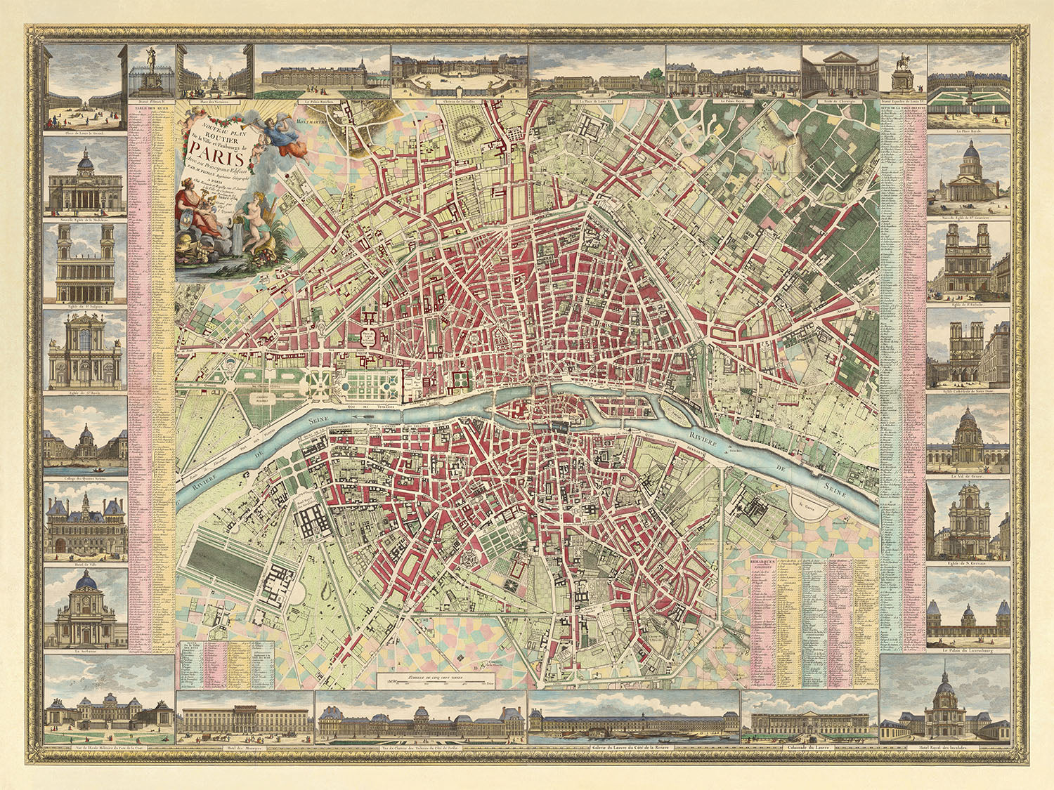
Inizia un viaggio nel tempo con il squisito "Nouveau Plan Routier de la Ville et Faubourgs de Paris," un capolavoro realizzato nel...
Continua a leggereInizia un viaggio nel tempo con il squisito "Nouveau Plan Routier de la Ville et Faubourgs de Paris," un capolavoro realizzato nel 1784 dal rinomato duo di cartografi Esnauts & Rapilly, con i contributi artistici di Michel Glot e M. Pichon. Questa mappa non è semplicemente uno strumento di navigazione, ma una finestra sull'anima di Parigi prima degli eventi tumultuosi della Rivoluzione Francese. La sua rappresentazione dettagliata delle strade, delle parrocchie e degli edifici notevoli della città, incorniciata da un sorprendente bordo floreale e da una cartuccia allegorica, cattura l'essenza di un'epoca in cui Parigi era il cuore dell'illuminismo e della cultura. Il design e lo stile intricati della mappa, con angeli e simboli delle arti e delle scienze, invitano gli ammiratori a esplorare il ricco arazzo della vita parigina e il suo patrimonio intellettuale.
La mappa divide meticolosamente Parigi in 12 arrondissement, ulteriormente segmentati in 48 quartieri, offrendo uno sguardo unico sul layout urbano prima delle trasformazioni moderne. Mostra quartieri significativi come il Faubourg Saint-Germain e il Faubourg Saint-Honoré, aree sinonimo di aristocrazia e lusso. Questi distretti, insieme ai boulevard e alle strade rappresentate come il Boulevard Bonne Nouvelle e la Rue de Rivoli, erano le arterie della città, pulsando con il ritmo della società parigina. L'inclusione di punti di riferimento come il Louvre e la Cattedrale di Notre Dame, accanto a strade meno monumentali ma altrettanto significative, crea un vivace ritratto della Parigi del XVIII secolo, rendendo questa mappa un tesoro sia per storici che per appassionati di cartografia urbana.
I fiumi e i corsi d'acqua sono sempre stati le vene attraverso cui scorre la linfa vitale di una città, e il "Nouveau Plan Routier" enfatizza questo con la sua rappresentazione centrale della Senna. Questo focus non solo evidenzia l'importanza del fiume nella geografia e nel commercio parigino, ma incornicia anche le viste più pittoresche della città e i luoghi di ritrovo dell'epoca. L'attenzione ai dettagli della mappa si estende alla rappresentazione di ponti come il Pont Neuf e il Pont Royal, cruciali per il loro ruolo nel connettere i quartieri diversi della città e facilitare il vivace scambio di beni e idee.
In mezzo al paesaggio urbano, la mappa non dimentica i polmoni verdi di Parigi. L'inclusione di grandi parchi come il Bois de Boulogne e il Bois de Vincennes, insieme al Lac de la Muette, offre un respiro d'aria fresca. Queste aree, rappresentate con cura e precisione, erano e continuano a essere essenziali fuggite per i parigini dalla frenesia della vita cittadina. La loro rappresentazione sulla mappa serve da promemoria dell'equilibrio tra sviluppo urbano e necessità di spazi naturali, un concetto tanto rilevante oggi quanto lo era nel XVIII secolo.
Infine, il "Nouveau Plan Routier" è una testimonianza dello spirito collaborativo dei suoi creatori, Esnauts & Rapilly, Michel Glot e M. Pichon. I loro sforzi combinati hanno prodotto non solo una mappa, ma un'opera d'arte che celebra le meraviglie architettoniche di Parigi e la vivacità delle sue strade e dei suoi quartieri. Le illustrazioni dettagliate dei punti di riferimento e gli elementi decorativi attorno al bordo della mappa arricchiscono l'esperienza dello spettatore, rendendola un'opera degna di ammirazione e studio. Questa mappa è più di un oggetto da collezione; è un omaggio all'attrattiva duratura di Parigi, una città che ha catturato cuori e menti attraverso i secoli.
Strade e vie su questa mappa
- Boulevard Bonne Nouvelle
- Boulevard des Capucines
- Boulevard de la Madeleine
- Boulevard du Temple
- Faubourg Saint-Antoine
- Faubourg Saint-Denis
- Faubourg Saint-Germain
- Faubourg Saint-Honoré
- Pont au Change
- Pont Louis XVI
- Pont Neuf
- Pont Royal
- Quai de Gesvres
- Quai des Tuileries
- Rue de Castiglione
- Rue de Rivoli
Caratteristiche e monumenti notevoli
- Mappe in miniatura di vari Faubourg tra cui Saint Germain, Saint Antoine e altri.
- Illustrazioni della cartuccia del titolo nell'angolo in alto a sinistra che presenta una scena allegorica del fiume Senna e della città di Parigi.
- Bordo decorativo con vari monumenti e scene della vita parigina.
- La mappa è divisa in 12 arrondissement, ulteriormente suddivisi in 48 quartieri.
- Presenta molti dei monumenti più famosi di Parigi, tra cui il Louvre, i Giardini delle Tuileries, il Palais Royal e altri.
- La mappa presenta il Lac de la Muette nel Bois de Boulogne.
- Grandi parchi come il Bois de Boulogne, il Bois de Vincennes e il Parc de Monceau sono inclusi.
Contesto storico e di design
- Titolo: Nouveau Plan Routier de la Ville et Faubourgs de Paris
- Data: 1784
- Cartografo/Editore: Esnauts & Rapilly; Michel Glot (incisore); M. Pichon (illustratore)
- Copertura: Parigi, Francia
- Temi: Mappa stradale cittadina; mostra strade, parrocchie, college, ospedali, edifici importanti, monumenti, piazze principali e altri punti di interesse
- Design/Stile: Bordo floreale; cartuccia del titolo che mostra angeli e un'allegoria di Parigi con i simboli delle arti e delle scienze; 28 illustrazioni in miniatura di luoghi e monumenti
- Significato storico: Rappresenta Parigi prima della Rivoluzione Francese
Si prega di controllare attentamente le immagini per assicurarsi che una specifica città o luogo sia mostrato su questa mappa. Puoi anche contattarci e chiedere di controllare la mappa per te.
Questa mappa appare fantastica in ogni dimensione, ma consiglio sempre di optare per una dimensione più grande se hai spazio. In questo modo puoi facilmente distinguere tutti i dettagli.
Questa mappa appare incredibile in dimensioni fino a 100in (250cm). Se stai cercando una mappa più grande, ti preghiamo di contattarci.
Si prega di notare: le etichette su questa mappa sono difficili da leggere se ordini una mappa che è 20in (50cm) o più piccola. La mappa è comunque molto attraente, ma se desideri leggere facilmente la mappa, ti preghiamo di acquistare una dimensione più grande.
Il modello nelle immagini dell'elenco tiene in mano la versione 18x24in (45x60cm) di questa mappa.
La quinta immagine dell'elenco mostra un esempio del mio servizio di personalizzazione della mappa.
Se stai cercando qualcosa di leggermente diverso, dai un'occhiata alla mia collezione delle migliori vecchie mappe per vedere se qualcosa attira la tua attenzione.
Per favore contattami per controllare se una certa posizione, monumento o caratteristica è mostrata su questa mappa.
Questo sarebbe un meraviglioso regalo per un compleanno, Natale, festa del papà, partenza dal lavoro, anniversario o inaugurazione della casa per qualcuno delle aree coperte da questa mappa.
Questa mappa è disponibile come stampa giclée su carta opaca archiviata senza acidi, oppure puoi acquistarla incorniciata. La cornice è una bella e semplice cornice nera che si adatta alla maggior parte degli stili. Ti preghiamo di contattarci se desideri un colore o un materiale per la cornice diverso. Le mie cornici sono dotate di un vetro acrilico super chiaro di qualità museale (perspex/acrylite), che è significativamente meno riflettente del vetro, più sicuro e arriverà sempre in perfette condizioni.
This map is also available as a float framed canvas, sometimes known as a shadow gap framed canvas or canvas floater. The map is printed on artist's cotton canvas and then stretched over a handmade box frame. We then "float" the canvas inside a wooden frame, which is available in a range of colours (black, dark brown, oak, antique gold and white). This is a wonderful way to present a map without glazing in front. See some examples of float framed canvas maps and explore the differences between my different finishes.
For something truly unique, this map is also available in "Unique 3D", our trademarked process that dramatically transforms the map so that it has a wonderful sense of depth. We combine the original map with detailed topography and elevation data, so that mountains and the terrain really "pop". For more info and examples of 3D maps, check my Unique 3D page.
Inizia un viaggio nel tempo con il squisito "Nouveau Plan Routier de la Ville et Faubourgs de Paris," un capolavoro realizzato nel 1784 dal rinomato duo di cartografi Esnauts & Rapilly, con i contributi artistici di Michel Glot e M. Pichon. Questa mappa non è semplicemente uno strumento di navigazione, ma una finestra sull'anima di Parigi prima degli eventi tumultuosi della Rivoluzione Francese. La sua rappresentazione dettagliata delle strade, delle parrocchie e degli edifici notevoli della città, incorniciata da un sorprendente bordo floreale e da una cartuccia allegorica, cattura l'essenza di un'epoca in cui Parigi era il cuore dell'illuminismo e della cultura. Il design e lo stile intricati della mappa, con angeli e simboli delle arti e delle scienze, invitano gli ammiratori a esplorare il ricco arazzo della vita parigina e il suo patrimonio intellettuale.
La mappa divide meticolosamente Parigi in 12 arrondissement, ulteriormente segmentati in 48 quartieri, offrendo uno sguardo unico sul layout urbano prima delle trasformazioni moderne. Mostra quartieri significativi come il Faubourg Saint-Germain e il Faubourg Saint-Honoré, aree sinonimo di aristocrazia e lusso. Questi distretti, insieme ai boulevard e alle strade rappresentate come il Boulevard Bonne Nouvelle e la Rue de Rivoli, erano le arterie della città, pulsando con il ritmo della società parigina. L'inclusione di punti di riferimento come il Louvre e la Cattedrale di Notre Dame, accanto a strade meno monumentali ma altrettanto significative, crea un vivace ritratto della Parigi del XVIII secolo, rendendo questa mappa un tesoro sia per storici che per appassionati di cartografia urbana.
I fiumi e i corsi d'acqua sono sempre stati le vene attraverso cui scorre la linfa vitale di una città, e il "Nouveau Plan Routier" enfatizza questo con la sua rappresentazione centrale della Senna. Questo focus non solo evidenzia l'importanza del fiume nella geografia e nel commercio parigino, ma incornicia anche le viste più pittoresche della città e i luoghi di ritrovo dell'epoca. L'attenzione ai dettagli della mappa si estende alla rappresentazione di ponti come il Pont Neuf e il Pont Royal, cruciali per il loro ruolo nel connettere i quartieri diversi della città e facilitare il vivace scambio di beni e idee.
In mezzo al paesaggio urbano, la mappa non dimentica i polmoni verdi di Parigi. L'inclusione di grandi parchi come il Bois de Boulogne e il Bois de Vincennes, insieme al Lac de la Muette, offre un respiro d'aria fresca. Queste aree, rappresentate con cura e precisione, erano e continuano a essere essenziali fuggite per i parigini dalla frenesia della vita cittadina. La loro rappresentazione sulla mappa serve da promemoria dell'equilibrio tra sviluppo urbano e necessità di spazi naturali, un concetto tanto rilevante oggi quanto lo era nel XVIII secolo.
Infine, il "Nouveau Plan Routier" è una testimonianza dello spirito collaborativo dei suoi creatori, Esnauts & Rapilly, Michel Glot e M. Pichon. I loro sforzi combinati hanno prodotto non solo una mappa, ma un'opera d'arte che celebra le meraviglie architettoniche di Parigi e la vivacità delle sue strade e dei suoi quartieri. Le illustrazioni dettagliate dei punti di riferimento e gli elementi decorativi attorno al bordo della mappa arricchiscono l'esperienza dello spettatore, rendendola un'opera degna di ammirazione e studio. Questa mappa è più di un oggetto da collezione; è un omaggio all'attrattiva duratura di Parigi, una città che ha catturato cuori e menti attraverso i secoli.
Strade e vie su questa mappa
- Boulevard Bonne Nouvelle
- Boulevard des Capucines
- Boulevard de la Madeleine
- Boulevard du Temple
- Faubourg Saint-Antoine
- Faubourg Saint-Denis
- Faubourg Saint-Germain
- Faubourg Saint-Honoré
- Pont au Change
- Pont Louis XVI
- Pont Neuf
- Pont Royal
- Quai de Gesvres
- Quai des Tuileries
- Rue de Castiglione
- Rue de Rivoli
Caratteristiche e monumenti notevoli
- Mappe in miniatura di vari Faubourg tra cui Saint Germain, Saint Antoine e altri.
- Illustrazioni della cartuccia del titolo nell'angolo in alto a sinistra che presenta una scena allegorica del fiume Senna e della città di Parigi.
- Bordo decorativo con vari monumenti e scene della vita parigina.
- La mappa è divisa in 12 arrondissement, ulteriormente suddivisi in 48 quartieri.
- Presenta molti dei monumenti più famosi di Parigi, tra cui il Louvre, i Giardini delle Tuileries, il Palais Royal e altri.
- La mappa presenta il Lac de la Muette nel Bois de Boulogne.
- Grandi parchi come il Bois de Boulogne, il Bois de Vincennes e il Parc de Monceau sono inclusi.
Contesto storico e di design
- Titolo: Nouveau Plan Routier de la Ville et Faubourgs de Paris
- Data: 1784
- Cartografo/Editore: Esnauts & Rapilly; Michel Glot (incisore); M. Pichon (illustratore)
- Copertura: Parigi, Francia
- Temi: Mappa stradale cittadina; mostra strade, parrocchie, college, ospedali, edifici importanti, monumenti, piazze principali e altri punti di interesse
- Design/Stile: Bordo floreale; cartuccia del titolo che mostra angeli e un'allegoria di Parigi con i simboli delle arti e delle scienze; 28 illustrazioni in miniatura di luoghi e monumenti
- Significato storico: Rappresenta Parigi prima della Rivoluzione Francese
Si prega di controllare attentamente le immagini per assicurarsi che una specifica città o luogo sia mostrato su questa mappa. Puoi anche contattarci e chiedere di controllare la mappa per te.
Questa mappa appare fantastica in ogni dimensione, ma consiglio sempre di optare per una dimensione più grande se hai spazio. In questo modo puoi facilmente distinguere tutti i dettagli.
Questa mappa appare incredibile in dimensioni fino a 100in (250cm). Se stai cercando una mappa più grande, ti preghiamo di contattarci.
Si prega di notare: le etichette su questa mappa sono difficili da leggere se ordini una mappa che è 20in (50cm) o più piccola. La mappa è comunque molto attraente, ma se desideri leggere facilmente la mappa, ti preghiamo di acquistare una dimensione più grande.
Il modello nelle immagini dell'elenco tiene in mano la versione 18x24in (45x60cm) di questa mappa.
La quinta immagine dell'elenco mostra un esempio del mio servizio di personalizzazione della mappa.
Se stai cercando qualcosa di leggermente diverso, dai un'occhiata alla mia collezione delle migliori vecchie mappe per vedere se qualcosa attira la tua attenzione.
Per favore contattami per controllare se una certa posizione, monumento o caratteristica è mostrata su questa mappa.
Questo sarebbe un meraviglioso regalo per un compleanno, Natale, festa del papà, partenza dal lavoro, anniversario o inaugurazione della casa per qualcuno delle aree coperte da questa mappa.
Questa mappa è disponibile come stampa giclée su carta opaca archiviata senza acidi, oppure puoi acquistarla incorniciata. La cornice è una bella e semplice cornice nera che si adatta alla maggior parte degli stili. Ti preghiamo di contattarci se desideri un colore o un materiale per la cornice diverso. Le mie cornici sono dotate di un vetro acrilico super chiaro di qualità museale (perspex/acrylite), che è significativamente meno riflettente del vetro, più sicuro e arriverà sempre in perfette condizioni.
This map is also available as a float framed canvas, sometimes known as a shadow gap framed canvas or canvas floater. The map is printed on artist's cotton canvas and then stretched over a handmade box frame. We then "float" the canvas inside a wooden frame, which is available in a range of colours (black, dark brown, oak, antique gold and white). This is a wonderful way to present a map without glazing in front. See some examples of float framed canvas maps and explore the differences between my different finishes.
For something truly unique, this map is also available in "Unique 3D", our trademarked process that dramatically transforms the map so that it has a wonderful sense of depth. We combine the original map with detailed topography and elevation data, so that mountains and the terrain really "pop". For more info and examples of 3D maps, check my Unique 3D page.
Many of our maps and art prints are chosen as thoughtful gifts for homes, offices, studies and meaningful places.
Choose a framed option for the easiest ready-to-hang gift, or choose an unframed print if the recipient may prefer to select their own frame.
We make orders locally in 23 countries around the world, so gifts can often be produced close to the recipient. This helps them arrive faster, travel more safely, and avoid customs or import duty surprises.
- We can deliver directly to the recipient
- Framed pieces arrive ready to hang
- Unframed prints are carefully packed in a strong protective tube
- Almost every order is made locally, for faster, safer gifting
- 90-day returns give the recipient time to decide
If you are not sure what to choose, please contact us. We can help you pick the right map, size, finish or delivery option.
Most orders are made locally and delivered in around 2–3 working days, depending on the product, size and destination.
We print and frame maps and artwork in 23 countries around the world, so your order is usually made close to you or your recipient. That means faster delivery, less time in transit, and no customs or import duty surprises.
Personalised and customised pieces usually take an extra 1–2 working days, because we prepare your design and send it to you for approval before printing.
Very large framed orders can take a little longer, as they need extra care in production and delivery.
Every order is carefully packaged: unframed prints are sent in a strong protective tube, while framed pieces are securely packed with protective materials around the frame.
If you need your order by a particular date, please contact us before ordering. We’ll check the best production route and delivery option for your location.
Express delivery is available at checkout for most countries. Next-day delivery is available in the UK, US, Singapore and the UAE.
Your order is covered by our 90-day returns policy and 10-year guarantee.
Our standard frame is a gallery-style black ash hardwood frame, with a simple, modern look. It is approximately 20mm (0.8in) wide. You can also view some lovely customer photos of framed maps and art.
We use super-clear acrylic glazing, also known as Perspex or Acrylite, instead of traditional glass. It is lighter, safer, and has lower reflectivity, giving the artwork a clearer, cleaner appearance.
Six standard frame colours are available at no extra cost: black, dark brown, dark grey, oak, white, and antique gold. Custom framing and mounting/matting is also available for customers looking for something more specific.
Most maps, art prints, and illustrations are also available as a framed canvas. We use matte cotton canvas, stretch it over a sustainably sourced wooden box frame, and then float the piece within a wooden outer frame. The finished result is beautifully presented, with no glazing between you and the artwork.
All frames are supplied ready to hang, with either string or brackets fitted to the back. Very large frames will include heavy-duty hanging plates and/or a mounting baton. If you have any questions, please get in touch.
We can also supply old maps and artwork on canvas, foam board, cotton rag, and other materials.
If you would prefer to frame your map or artwork yourself, please read our size guide before ordering.
My maps are extremely high quality reproductions of original maps.
I source original, rare maps from libraries, auction houses and private collections around the world, restore them at my London workshop, and then use specialist giclée inks and printers to create beautiful maps that look even better than the original.
My maps are printed on acid-free archival matte (not glossy) paper that feels very high quality and almost like card. In technical terms the paper weight/thickness is 10mil/200gsm. It's perfect for framing.
I print with Epson ultrachrome giclée UV fade resistant pigment inks - some of the best inks you can find.
I can also make maps on canvas, cotton rag and other exotic materials.
Learn more about The Unique Maps Co.
Map personalisation
If you're looking for the perfect anniversary or housewarming gift, I can personalise your map to make it truly unique. For example, I can add a short message, or highlight an important location, or add your family's coat of arms.
The options are almost infinite. Please see my map personalisation page for some wonderful examples of what's possible.
To order a personalised map, select "personalise your map" before adding it to your basket.
Get in touch if you're looking for more complex customisations and personalisations.
Map ageing
I have been asked hundreds of times over the years by customers if they could buy a map that looks even older.
Well, now you can, by selecting Aged before you add a map to your basket.
All the product photos you see on this page show the map in its Original form. This is what the map looks like today.
If you select Aged, I will age your map by hand, using a special and unique process developed through years of studying old maps, talking to researchers to understand the chemistry of aging paper, and of course... lots of practice!
If you're unsure, stick to the Original colour of the map. If you want something a bit darker and older looking, go for Aged.
Se non sei soddisfatto del tuo ordine per qualsiasi motivo, contattami per un rimborso senza problemi. Si prega di consultare la nostra politica di reso e rimborso per ulteriori informazioni.
Sono molto sicuro che ti piacerà la tua mappa restaurata o la stampa d'arte. Lo faccio dal 1984. Sono un venditore Etsy a 5 stelle. Ho venduto decine di migliaia di mappe e stampe d'arte e ho oltre 5.000 recensioni reali a 5 stelle.
Utilizzo un processo unico per restaurare mappe e opere d'arte che richiede molto tempo e lavoro. Trovare le mappe e le illustrazioni originali può richiedere mesi. Utilizzo tecnologia all'avanguardia e incredibilmente costosa per scannerizzare e restaurarle. Di conseguenza, garantisco che le mie mappe e stampe d'arte siano superiori alle altre - ecco perché posso offrire un rimborso senza problemi.
Quasi tutte le mie mappe e stampe d'arte sembrano fantastiche a grandi dimensioni (200 cm, 6,5 piedi+) e posso anche incorniciarle e consegnarle a te, tramite un corriere speciale per oggetti di grandi dimensioni. Contattami per discutere delle tue esigenze specifiche.
Or try searching for something!


