


Mappa Pittorica Antica del Kenya, 1968: Safari, Animali, Nairobi, Monte Kenya, Lago Vittoria
Compra 2, Ricevi 1 Gratuito
Se aggiungi 2 articoli al tuo carrello, puoi aggiungere un terzo prodotto gratuitamente.
Questo vale per tutte le mappe e opere d'arte, comprese le opere personalizzate e su misura. Puoi ordinare 3 dello stesso articolo, o 3 articoli diversi.
Questo equivale a uno sconto del 33%, che sarà il maggiore sconto disponibile nel mio negozio quest'anno.
Ti prego di approfittare dell'offerta e di coprire le tue pareti con bellissime mappe e opere d'arte!
Contattami se hai domande.
-
![]() Handmade locally in the EU
Handmade locally in the EU

-
FREE worldwide delivery in 2-3 days ⓘ
Free delivery in 2-3 days
Your map should be delivered in 2-3 working days with free delivery, worldwide.
We make maps by hand locally in 23 countries, including the EU
![]() . If you're buying a gift for someone in another country, we will make the map locally to them.
. If you're buying a gift for someone in another country, we will make the map locally to them.You will never pay import tax or customs duty.
Express delivery is available at checkout which can reduce the delivery time to 1-2 days.
Please note that personalised maps, and larger framed maps, can take longer to produce and deliver.
If you need your order to arrive by a certain date, contact me and we can discuss your options.
-
Complimentary gifting & design advice
ⓘ
Complimentary gifting & design advice
Available almost 24/7 on WhatsApp and email — we usually reply within minutes. We can help you:
- Choose a perfectly personalised gift
- Send a digital gift preview to the recipient
- Pick the ideal size for your wall
- Select the right finish and frame
Quick, friendly advice so you can order with confidence.
For last minute gifts, consider buying a digital gift card. We have over 5,000 maps and art prints to choose from.
-
90-day returns & 5-year guarantee
ⓘ
90 giorni per restituire e ricevere un rimborso
I prodotti possono essere restituiti entro 90 giorni per un rimborso completo, o cambio con un altro prodotto.
Per articoli personalizzati e su misura, potremmo offrirti un credito in negozio o una carta regalo non scadente, poiché non possiamo rivendere ordini personalizzati.
Se hai domande, contattaci. Per ulteriori informazioni, consulta la nostra politica di restituzione e cambio.

This is a museum-grade archival print from the original 1968 map — restored in our workshop and made to order on 220gsm archival matte paper or 400gsm artist's cotton canvas with pigment inks.
Professional framing & free personalisation available.
1. Choose a size
2. Frame & personalise your map
Make your map unique with framing, hand-drawn customisation, vintage ageing, pop art text, unique 3D styling and more.


Gift message & custom finish

If you want to add a gift message, or a finish (jigsaw, aluminium board, etc.) that is not available here, please request it in the "order note" when you check out.
Every order is custom made, so if you need the size adjusted slightly, or printed on an unusual material, just let us know. We've done thousands of custom orders over the years, so there's (almost) nothing we can't manage.
You can also contact us before you order, if you prefer!

- Handmade locally. No import duty or tax
- FREE worldwide delivery
- 90-day returns & 5-year product guarantee
- Questions? WhatsApp me any time
Own a piece of history
7,000+ 5 star reviews


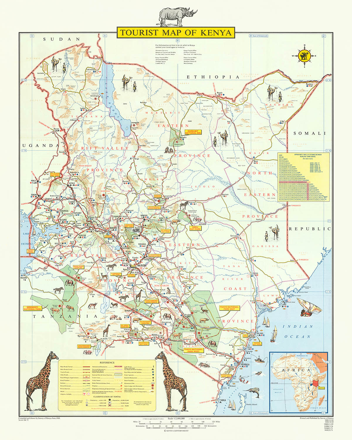
Inizia un viaggio attraverso il tempo e lo spazio con la "Mappa Turistica del Kenya", una rappresentazione pittorica vivace e dettagliata realizzata dal Survey of Kenya nel 1968. Questa mappa, testimone del ricco patrimonio e della bellezza naturale del Kenya, è stata creata in seguito all'indipendenza del paese dal Regno Unito, simboleggiando una nuova era di autodeterminazione e un forte interesse nel mostrare le sue meraviglie al mondo. Il Survey of Kenya, un'istituzione con una storia prestigiosa di eccellenza cartografica, ha illustrato meticolosamente i vasti paesaggi della nazione, dalle città vivaci di Nairobi e Mombasa alle serene distese dei suoi parchi nazionali e riserve. Questa mappa non solo funge da guida, ma anche da narrazione colorata del viaggio del Kenya verso l'indipendenza e delle sue aspirazioni per il futuro.
Il design della mappa è una festa per gli occhi, impiegando uno stile pittorico che dà vita ai diversi ecosistemi e alla fauna selvatica del Kenya. Illustrazioni di animali maestosi come leoni, elefanti e rinoceronti punteggiano il paesaggio, invitando gli spettatori a esplorare gli habitat naturali che rendono il Kenya un paradiso per gli appassionati di fauna selvatica. Oltre al suo fascino estetico, la mappa è un ricco deposito di informazioni, dettagliando strade, ferrovie, aeroporti e attrazioni turistiche, rendendola una risorsa inestimabile per avventurieri e studiosi. L'inclusione dei paesi vicini Uganda, Tanzania, Somalia, Etiopia e Sudan fornisce contesto al paesaggio geografico e culturale del Kenya, enfatizzando il suo ruolo come nazione fondamentale nell'Africa orientale.
Storicamente, la mappa è un riflesso di un momento cruciale nella storia del Kenya, appena cinque anni dopo aver ottenuto l'indipendenza. Funziona come una celebrazione visiva dell'identità nazionale, mostrando le sue meraviglie naturali e i suoi punti di riferimento culturali per attrarre turisti e promuovere un senso di orgoglio nazionale. La rappresentazione dettagliata delle province, delle riserve di caccia e dei parchi nazionali del Kenya, accompagnata da affascinanti illustrazioni di animali, cattura l'essenza dell'impegno del paese per la conservazione e il suo status di santuario per alcune delle specie di fauna selvatica più iconiche del mondo.
La mappa non è solo uno strumento di navigazione, ma una tela che narra la storia del Kenya, dalle sue radici pre-coloniali alle sue aspirazioni come nazione appena indipendente desiderosa di accogliere il mondo. Sottolinea città e paesi chiave, ognuno con la propria storia unica e il proprio contributo al tessuto culturale del Kenya. Nairobi, la capitale, emerge come una metropoli vivace, mentre il fascino costiero e il significato storico di Mombasa sono messi in evidenza. Questa rappresentazione dettagliata invita all'esplorazione e alla scoperta, offrendo uno sguardo nel cuore del Kenya.
In conclusione, la "Mappa Turistica del Kenya" è più di una semplice creazione cartografica; è un ponte che collega passato, presente e futuro. Realizzata dal Survey of Kenya, questa mappa racchiude lo spirito di una nazione a un bivio, desiderosa di tracciare il proprio corso mentre celebra il suo ricco patrimonio. Si erge come un testimone della bellezza e della diversità del Kenya, invitando viaggiatori, storici e sognatori a esplorare i suoi paesaggi, la sua fauna selvatica e le sue storie. Questa mappa non è solo una guida, ma un tesoro, un pezzo di storia che continua a ispirare e informare le generazioni.
Città e paesi su questa mappa
- Nairobi (3.500.000)
- Mombasa (1.200.000)
- Kisumu (400.000)
- Nakuru (300.000)
- Eldoret (250.000)
- Meru (200.000)
- Nyeri (200.000)
- Kakamega (200.000)
- Machakos (200.000)
- Kitale (150.000)
- Thika (150.000)
- Malindi (150.000)
- Lamu (150.000)
- Garissa (150.000)
- Voi (100.000)
- Isiolo (100.000)
- Wajir (100.000)
- Mandera (100.000)
Caratteristiche e Luoghi Notevoli
- Monte Kenya
- Monte Kilimanjaro
- lago Vittoria
- lago Turkana
- oceano Indiano
- fiume Tana
- fiume Athi
- fiume Galana
- fiume Ewaso Ng'iro
- fiume Mara
- fiume Voi
- fiume Tsavo
- fiume Sabaki
- fiume Uaso Nyiro
- lago Naivasha
- lago Nakuru
- lago Baringo
- lago Bogoria
- lago Turkana
- lago Jipe
- lago Chala
- lago Magadi
- lago Elementeita
- Monte Longonot
- Monte Suswa
- Monte Meru
- Monte Elgon
- Monte Marsabit
- Monte Kulal
- catena montuosa Aberdare
- Colline Cherangani
- scarpata Mau
- Colline Ngong
- Colline Shimba
- Colline Taita
- Colline Chyulu
- Colline Loita
- catena montuosa Mathews
- Monti Ndoto
- Colline Samburu
- Altopiano Lorogi
- Altopiano Laikipia
- Altopiano Kinangop
- Altopiano Mau Narok
- Pianure Mara
- Pianure Serengeti
- Pianure Tsavo
- delta del Tana
- arcipelago di Lamu
- Parco Nazionale Marino di Malindi
- Parco Nazionale Marino di Watamu
- Parco Nazionale Marino di Mombasa
- Parco Nazionale Marino di Kisite
- spiaggia di Diani
- spiaggia di Nyali
- spiaggia di Bamburi
- spiaggia di Shanzu
- spiaggia di Tiwi
- spiaggia di Watamu
- spiaggia di Malindi
- spiaggia di Lamu
- spiaggia di Shela
- spiaggia di Manda
- spiaggia di Kiwayu
- spiaggia di Vanga
- spiaggia di Shimoni
- spiaggia di Msambweni
- spiaggia di Gazi
- spiaggia di Galu
- spiaggia di Kinondo
- spiaggia di Ngomeni
- spiaggia di Mkunguni
- spiaggia di Chale
- spiaggia di Funzi
- isola di Pemba
- isola di Zanzibar
- isola di Mafia
- isola di Lamu
- isola di Manda
- isola di Paté
- isola di Siyu
- isola di Kiwayu
- isola di Tanga
- isola di Pangani
- isola di Latham
- isola di Mnemba
- isola di Chumbe
- isola di Vamizi
- isola di Koyama
- isola di Tumbatu
- isola di Mkokotoni
- isola di Changuu
- isola di Bawe
- isola di Unguja Ukuu
- confine Kenya-Etiopia
- confine Kenya-Somalia
- confine Kenya-Tanzania
- confine Kenya-Uganda
- confine Kenya-Sudan
Contesto storico e di design
- Titolo: Mappa Turistica del Kenya
- Data: 1968
- Cartografo: Survey of Kenya
- Copertura: La mappa copre l'interezza del Kenya, così come parti dei paesi vicini di Uganda, Tanzania, Somalia, Etiopia e Sudan.
- Temi: La mappa mostra una varietà di informazioni, comprese strade, ferrovie, aeroporti, parchi nazionali, riserve di caccia e attrazioni turistiche.
- Design: La mappa è una mappa pittorica, il che significa che utilizza illustrazioni per rappresentare diverse caratteristiche. La mappa è anche piuttosto colorata, il che la rende visivamente attraente.
- Significato storico: La mappa è stata pubblicata nel 1968, cinque anni dopo che il Kenya ha ottenuto l'indipendenza dal Regno Unito. La mappa è un riflesso della nuova indipendenza del paese e del suo desiderio di promuovere il turismo.
Si prega di controllare attentamente le immagini per assicurarsi che una specifica città o luogo sia mostrato su questa mappa. Puoi anche contattarci e chiedere di controllare la mappa per te.
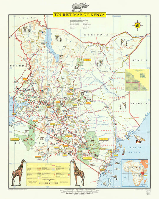
Questa mappa appare fantastica in ogni dimensione, ma consiglio sempre di optare per una dimensione più grande se hai spazio. In questo modo puoi facilmente distinguere tutti i dettagli.
Questa mappa sembra incredibile in dimensioni fino a 100in (250cm). Se stai cercando una mappa più grande, per favore contattaci.
Si prega di notare: le etichette su questa mappa sono difficili da leggere se si ordina una mappa di 20in (50cm) o più piccola. La mappa è comunque molto attraente, ma se desideri leggere facilmente la mappa, ti preghiamo di acquistare una dimensione più grande.
Il modello nelle immagini dell'annuncio tiene la versione 16x20in (40x50cm) di questa mappa.
La quinta immagine dell'annuncio mostra un esempio del mio servizio di personalizzazione della mappa.
Se stai cercando qualcosa di leggermente diverso, dai un'occhiata alla mia collezione delle migliori mappe antiche per vedere se qualcosa attira la tua attenzione.
Per favore contattami per verificare se una certa posizione, punto di riferimento o caratteristica è mostrata su questa mappa.
Questo sarebbe un regalo meraviglioso per un compleanno, Natale, Festa del Papà, addio al lavoro, anniversario o inaugurazione della casa per qualcuno delle aree coperte da questa mappa.
Questa mappa è disponibile come stampa giclée su carta opaca archiviata senza acidi, oppure puoi acquistarla incorniciata. La cornice è una semplice cornice nera che si adatta alla maggior parte degli stili. Ti preghiamo di contattarci se desideri un colore o un materiale di cornice diverso. Le mie cornici sono rivestite con acrilico (perspex/acrylite) di grado museo super chiaro, che è significativamente meno riflettente del vetro, più sicuro e arriverà sempre in perfette condizioni.
This map is also available as a float framed canvas, sometimes known as a shadow gap framed canvas or canvas floater. The map is printed on artist's cotton canvas and then stretched over a handmade box frame. We then "float" the canvas inside a wooden frame, which is available in a range of colours (black, dark brown, oak, antique gold and white). This is a wonderful way to present a map without glazing in front. See some examples of float framed canvas maps and explore the differences between my different finishes.
For something truly unique, this map is also available in "Unique 3D", our trademarked process that dramatically transforms the map so that it has a wonderful sense of depth. We combine the original map with detailed topography and elevation data, so that mountains and the terrain really "pop". For more info and examples of 3D maps, check my Unique 3D page.
For most orders, delivery time is about 3 working days. Personalised and customised products take longer, as I have to do the personalisation and send it to you for approval, which usually takes 1 or 2 days.
Please note that very large framed orders usually take longer to make and deliver.
If you need your order to arrive by a certain date, please contact me before you order so that we can find the best way of making sure you get your order in time.
I print and frame maps and artwork in 23 countries around the world. This means your order will be made locally, which cuts down on delivery time and ensures that it won't be damaged during delivery. You'll never pay customs or import duty, and we'll put less CO2 into the air.
All of my maps and art prints are well packaged and sent in a rugged tube if unframed, or surrounded by foam if framed.
I try to send out all orders within 1 or 2 days of receiving your order, though some products (like face masks, mugs and tote bags) can take longer to make.
If you select Express Delivery at checkout your order we will prioritise your order and send it out by 1-day courier (Fedex, DHL, UPS, Parcelforce).
Next Day delivery is also available in some countries (US, UK, Singapore, UAE) but please try to order early in the day so that we can get it sent out on time.
My standard frame is a gallery style black ash hardwood frame. It is simple and quite modern looking. My standard frame is around 20mm (0.8in) wide.
I use super-clear acrylic (perspex/acrylite) for the frame glass. It's lighter and safer than glass - and it looks better, as the reflectivity is lower.
Six standard frame colours are available for free (black, dark brown, dark grey, oak, white and antique gold). Custom framing and mounting/matting is available if you're looking for something else.
Most maps, art and illustrations are also available as a framed canvas. We use matte (not shiny) cotton canvas, stretch it over a sustainably sourced box wood frame, and then 'float' the piece within a wood frame. The end result is quite beautiful, and there's no glazing to get in the way.
All frames are provided "ready to hang", with either a string or brackets on the back. Very large frames will have heavy duty hanging plates and/or a mounting baton. If you have any questions, please get in touch.
See some examples of my framed maps and framed canvas maps.
Alternatively, I can also supply old maps and artwork on canvas, foam board, cotton rag and other materials.
If you want to frame your map or artwork yourself, please read my size guide first.
Alcune delle mie vecchie mappe sono ora disponibili come tele incorniciate. Per favore contattami se desideri ordinare una dimensione che non è disponibile nel mio negozio.
Le vecchie mappe su tela sono un'alternativa interessante alle mappe incorniciate in modo convenzionale. A seconda del tuo gusto personale e dell'arredamento della stanza, le mappe su tela possono "risaltare" un po' di più rispetto a una mappa incorniciata.
My maps are extremely high quality reproductions of original maps.
I source original, rare maps from libraries, auction houses and private collections around the world, restore them at my London workshop, and then use specialist giclée inks and printers to create beautiful maps that look even better than the original.
My maps are printed on acid-free archival matte (not glossy) paper that feels very high quality and almost like card. In technical terms the paper weight/thickness is 10mil/200gsm. It's perfect for framing.
I print with Epson ultrachrome giclée UV fade resistant pigment inks - some of the best inks you can find.
I can also make maps on canvas, cotton rag and other exotic materials.
Learn more about The Unique Maps Co.
Map personalisation
If you're looking for the perfect anniversary or housewarming gift, I can personalise your map to make it truly unique. For example, I can add a short message, or highlight an important location, or add your family's coat of arms.
The options are almost infinite. Please see my map personalisation page for some wonderful examples of what's possible.
To order a personalised map, select "personalise your map" before adding it to your basket.
Get in touch if you're looking for more complex customisations and personalisations.
Map ageing
I have been asked hundreds of times over the years by customers if they could buy a map that looks even older.
Well, now you can, by selecting Aged before you add a map to your basket.
All the product photos you see on this page show the map in its Original form. This is what the map looks like today.
If you select Aged, I will age your map by hand, using a special and unique process developed through years of studying old maps, talking to researchers to understand the chemistry of aging paper, and of course... lots of practice!
If you're unsure, stick to the Original colour of the map. If you want something a bit darker and older looking, go for Aged.
Se non sei soddisfatto del tuo ordine per qualsiasi motivo, contattami per un rimborso senza problemi. Si prega di consultare la nostra politica di reso e rimborso per ulteriori informazioni.
Sono molto sicuro che ti piacerà la tua mappa restaurata o la stampa d'arte. Lo faccio dal 1984. Sono un venditore Etsy a 5 stelle. Ho venduto decine di migliaia di mappe e stampe d'arte e ho oltre 5.000 recensioni reali a 5 stelle.
Utilizzo un processo unico per restaurare mappe e opere d'arte che richiede molto tempo e lavoro. Trovare le mappe e le illustrazioni originali può richiedere mesi. Utilizzo tecnologia all'avanguardia e incredibilmente costosa per scannerizzare e restaurarle. Di conseguenza, garantisco che le mie mappe e stampe d'arte siano superiori alle altre - ecco perché posso offrire un rimborso senza problemi.
Quasi tutte le mie mappe e stampe d'arte sembrano fantastiche a grandi dimensioni (200 cm, 6,5 piedi+) e posso anche incorniciarle e consegnarle a te, tramite un corriere speciale per oggetti di grandi dimensioni. Contattami per discutere delle tue esigenze specifiche.
Or try searching for something!


