


Vecchia mappa del potente fiume Hudson di Waugh, 1958: NYC a Saratoga, cascate, battelli a vapore

-
![]() Handmade locally in the EU
Handmade locally in the EU
-
FREE worldwide delivery in 2-3 days ⓘ
Free delivery in 2-3 days
Your map should be delivered in 2-3 working days with free delivery, worldwide.
We make maps by hand locally in 23 countries, including the EU
![]() . If you're buying a gift for someone in another country, we will make the map locally to them.
. If you're buying a gift for someone in another country, we will make the map locally to them.You will never pay import tax or customs duty.
Express delivery is available at checkout which can reduce the delivery time to 1-2 days.
Please note that personalised maps, and larger framed maps, can take longer to produce and deliver.
If you need your order to arrive by a certain date, contact me and we can discuss your options.
-
90 day money back guarantee
ⓘ
90 giorni per restituire e ottenere un rimborso
I prodotti possono essere restituiti entro 90 giorni per un rimborso completo, o scambio con un altro prodotto.
Per articoli personalizzati o su misura, potremmo offrirti un credito in negozio o una carta regalo non scadente, poiché non possiamo rivendere ordini personalizzati.
Se hai domande, contattaci. Per ulteriori informazioni, consulta la nostra politica di restituzione e scambio.

My maps are rare, museum-grade, restored old maps sourced from libraries, auction houses and private collections across the globe.
Framing & free personalisation available
1. Select your size
2. Frame & personalise your map
Make your map unique with framing, hand-drawn customisation, vintage ageing, pop art text, unique 3D styling and moreGift message & custom finish

If you want to add a gift message, or a finish (jigsaw, aluminium board, etc.) that is not available here, please request it in the "order note" when you check out.
Every order is custom made, so if you need the size adjusted slightly, or printed on an unusual material, just let us know. We've done thousands of custom orders over the years, so there's (almost) nothing we can't manage.
You can also contact us before you order, if you prefer!

- Handmade locally. No import duty or tax
- FREE Delivery. Arrives in 2-3 days
- Love it or your money back
- Questions? WhatsApp me any time
Own a piece of history
5,000+ 5 star reviews


Intraprendi un viaggio affascinante lungo il possente fiume Hudson con "Una mappa del potente fiume Hudson," un'opera magistrale del rinomato artista e cartografo americano Coulton Waugh. Realizzata nel 1958, questa mappa pittorica non è solo uno strumento di navigazione, ma un vivace arazzo che intreccia la ricca storia, cultura e bellezza geografica dello Stato di New York. Con meticolosa attenzione ai dettagli, Waugh dà vita al viaggio del fiume Hudson dalle affollate strade di New York City ai paesaggi sereni di Saratoga, catturando l'essenza del fiume e dei suoi dintorni attraverso quattro sezioni dettagliate.
La mappa è adornata con un bordo che è tanto informativo quanto artistico, caratterizzato da ritratti di figure notevoli che hanno plasmato la storia della regione, incluso un'importante raffigurazione di Henry Hudson, il nome del fiume. Questa decorazione non solo rende omaggio agli individui che hanno lasciato il loro segno nella Valle del fiume Hudson, ma funge anche da cronaca visiva, con il lato destro del bordo che presenta una cronologia storica grafica. Questa caratteristica unica invita gli spettatori a immergersi nel passato, esplorando il significato del fiume attraverso i secoli.
Un punto saliente della creazione di Waugh è l'inclusione della Mary Powell, una famosa nave a vapore del fiume Hudson, rappresentata con dettagli squisiti nella sezione principale della mappa. Questa inclusione è un omaggio al ruolo fondamentale del fiume nei trasporti e nel commercio, celebrando i progressi tecnologici che hanno attraversato le sue acque. Il bordo inferiore della mappa, che mostra varie case storiche, arricchisce ulteriormente la narrazione, offrendo uno sguardo sul patrimonio architettonico che punteggia le rive del fiume.
La mappa di Coulton Waugh trascende i confini convenzionali della cartografia, incorporando note e immagini in insetto che forniscono una comprensione più profonda dei luoghi storici e culturali del fiume Hudson. Dall'accademia militare di West Point alla comunità artistica di Woodstock, ogni annotazione è una testimonianza dell'identità multifaccettata del fiume. Il focus tematico della mappa sul fiume Hudson è un tributo alla sua influenza duratura, evidenziando non solo la sua bellezza naturale, ma anche il suo ruolo come musa per gli artisti, un corridoio per gli esploratori e una linea vitale per le comunità.
In conclusione, "Una mappa del potente fiume Hudson" è un artefatto lussuoso che offre più di una semplice guida geografica; è un documento storico, un capolavoro artistico e un tesoro culturale. L'opera di Coulton Waugh invita collezionisti, storici e appassionati d'arte a esplorare l'eredità del fiume Hudson, celebrando il suo impatto indelebile sul paesaggio americano. Questa mappa non è solo un ritratto di un fiume; è un viaggio attraverso il tempo, una celebrazione del patrimonio e una testimonianza dell'attrattiva duratura del fiume Hudson.
Luoghi su questa mappa
- New York City
- Bear Mountain
- Kingston
- Castleton
- Saratoga
- Albany
- Troy
- Schenectady
- Poughkeepsie
- Newburgh
- Hudson
- Catskill
- Haverstraw
- Peekskill
- Yonkers
- Tarrytown
- Ossining
- Croton
- Verplanck
- Hastings-on-Hudson
- Dobbs Ferry
- Irvington
- Ardsley
- Scarsdale
- Mamaroneck
- Larchmont
- New Rochelle
- Pelham
- Mount Vernon
- Bronx
- Throgs Neck
- College Point
- Whitestone
- Flushing
- Bayside
- Douglaston
- Little Neck
- Great Neck
- Manhasset
- Port Washington
- Sands Point
- Kings Point
- Great Neck Estates
- Thomaston
- Roslyn
- East Williston
- Albertson
- Herricks
- Garden City
- Mineola
- Hempstead
- Uniondale
- Roosevelt
- Freeport
- Merrick
- Bellmore
- Wantagh
- Seaford
- Massapequa
- Amityville
- Copiague
- Lindenhurst
- Babylon
- West Babylon
- North Babylon
- Deer Park
- Brentwood
- Islip
- Central Islip
- Hauppauge
- Smithtown
- Kings Park
- Fort Salonga
- Northport
- East Northport
- Huntington
- Greenlawn
- Centerport
- Asharoken
Caratteristiche e monumenti notevoli
- West Point
- Croton Point
- Tappan Zee
- Peekskill
- Newburgh
- Poughkeepsie
- Kingston
- Rhinebeck
- Hudson
- Catskill
- Albany
- Troy
- Cohoes
- Waterford
- Schenectady
- Amsterdam
- Fort Orange
- Rensselaerswyck
- Beverwijck
- Wiltwyck
- Esopus
- Hurley
- Marbletown
- Rochester
- Charlotte
- Pittsford
- Mendon
- Brighton
- Henrietta
- Penfield
- Webster
- Irondequoit
- Greece
- Gates
- Chili
- Ogden
- Parma
- Riga
- Bergen
- Sweden
- Clarkson
- Hamlin
- Kendall
- Alabama
- Batavia
- Pembroke
- Darien
- Alexander
- Bennington
- Hoosick
- Schaghticoke
- Cambridge
- Easton
- Greenwich
- Stillwater
- Saratoga Springs
- Schuylerville
- Fort Edward
- Fort Miller
- Fort Ann
- Whitehall
- Skenesborough
- Ticonderoga
- Crown Point
- Fort Frederick
- Fort Frontenac
- Kingston
- Montreal
- Lachine
- Cascades
- Coteau-du-Lac
- Cedars
- Split Rock
- Galop Rapids
- Prescott
- Ogdensburg
- Brockville
- Thousand Islands
- Alexandria Bay
- Clayton
- Cape Vincent
- Sackets Harbor
- Oswego
- Fort Ontario
- Three Rivers
- Fulton
- Phoenix
- Baldwinsville
- Liverpool
- Salina
- Syracuse
- Geddes
- Camillus
- Marcellus
- Skaneateles
- Jordan
- Weedsport
- Montezuma
- Savannah
- Clyde
- Lyons
- Newark
- Palmyra
- Macedon
- Fiume Genesee
- Cascate del Niagara
- Isola Grande
- Tonawanda
- North Tonawanda
- Buffalo
- Black Rock
- Fort Erie
- Chippewa
- Queenston
- Lundy's Lane
- Fort George
- Niagara-on-the-Lake
- St. Catharines
- Thorold
- Welland
- Port Colborne
- Fort Schlosser
- Buffalo Creek
- Scajaquada Creek
- Tonawanda Creek
- Ellicott Creek
- Cattaraugus Creek
- Tonawanda Island
- Navy Island
- Goat Island
- Cascate a ferro di cavallo
- Cascate americane
- Cascate Bridal Veil
Contesto storico e di design
- Una mappa pittorica del fiume Hudson in quattro sezioni che mostra il fiume da New York City a Bear Mountain, a Kingston, a Castleton e a Saratoga.
- Un bordo circonda la mappa principale e include ritratti di famose personalità locali, come politici, e un ritratto più grande di Henry Hudson al centro.
- Il lato destro del bordo fornisce una linea temporale storica grafica.
- Varie case storiche sono mostrate nel bordo inferiore, e una mappa a grandezza naturale del fiume appare nel bordo sinistro.
- La Mary Powell, una famosa nave a vapore del fiume Hudson, è mostrata in fondo alla sezione principale della mappa.
- Include un cartiglio del titolo.
- Note e immagini in rilievo sono incluse per mostrare informazioni storiche.
Si prega di controllare attentamente le immagini per assicurarsi che una specifica città o luogo sia mostrato su questa mappa. Puoi anche contattarci e chiedere di controllare la mappa per te.
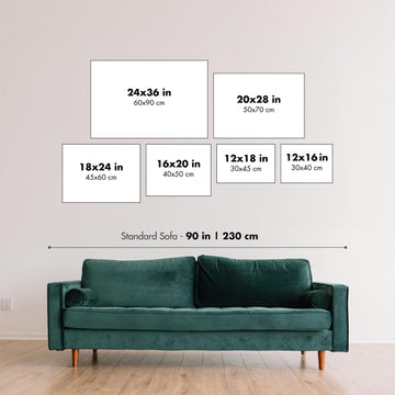
Questa mappa appare fantastica in ogni dimensione, ma consiglio sempre di optare per una dimensione più grande se hai spazio. In questo modo puoi facilmente distinguere tutti i dettagli.
Questa mappa appare incredibile in dimensioni fino a 90in (230cm). Se stai cercando una mappa più grande, per favore contattaci.
Il modello nelle immagini dell'elenco sta tenendo la versione 18x24in (45x60cm) di questa mappa.
La quinta immagine dell'elenco mostra un esempio del mio servizio di personalizzazione della mappa.
Se stai cercando qualcosa di leggermente diverso, dai un'occhiata alla mia collezione delle migliori mappe antiche per vedere se qualcosa attira la tua attenzione.
Per favore contattami per verificare se una certa posizione, un punto di riferimento o una caratteristica è mostrata su questa mappa.
Questa sarebbe una meravigliosa idea regalo per un compleanno, Natale, Festa del Papà, pensionamento, anniversario o inaugurazione della casa per qualcuno delle aree coperte da questa mappa.
Questa mappa è disponibile come stampa giclée su carta opaca archiviata senza acidi, oppure puoi acquistarla incorniciata. La cornice è una semplice cornice nera che si adatta alla maggior parte degli stili. Per favore contattaci se desideri un colore o un materiale di cornice diverso. Le mie cornici sono dotate di un acrilico super chiaro di grado museale (perspex/acrylite), che è significativamente meno riflettente del vetro, più sicuro e arriverà sempre in perfette condizioni.
This map is also available as a float framed canvas, sometimes known as a shadow gap framed canvas or canvas floater. The map is printed on artist's cotton canvas and then stretched over a handmade box frame. We then "float" the canvas inside a wooden frame, which is available in a range of colours (black, dark brown, oak, antique gold and white). This is a wonderful way to present a map without glazing in front. See some examples of float framed canvas maps and explore the differences between my different finishes.
For something truly unique, this map is also available in "Unique 3D", our trademarked process that dramatically transforms the map so that it has a wonderful sense of depth. We combine the original map with detailed topography and elevation data, so that mountains and the terrain really "pop". For more info and examples of 3D maps, check my Unique 3D page.
For most orders, delivery time is about 3 working days. Personalised and customised products take longer, as I have to do the personalisation and send it to you for approval, which usually takes 1 or 2 days.
Please note that very large framed orders usually take longer to make and deliver.
If you need your order to arrive by a certain date, please contact me before you order so that we can find the best way of making sure you get your order in time.
I print and frame maps and artwork in 23 countries around the world. This means your order will be made locally, which cuts down on delivery time and ensures that it won't be damaged during delivery. You'll never pay customs or import duty, and we'll put less CO2 into the air.
All of my maps and art prints are well packaged and sent in a rugged tube if unframed, or surrounded by foam if framed.
I try to send out all orders within 1 or 2 days of receiving your order, though some products (like face masks, mugs and tote bags) can take longer to make.
If you select Express Delivery at checkout your order we will prioritise your order and send it out by 1-day courier (Fedex, DHL, UPS, Parcelforce).
Next Day delivery is also available in some countries (US, UK, Singapore, UAE) but please try to order early in the day so that we can get it sent out on time.
My standard frame is a gallery style black ash hardwood frame. It is simple and quite modern looking. My standard frame is around 20mm (0.8in) wide.
I use super-clear acrylic (perspex/acrylite) for the frame glass. It's lighter and safer than glass - and it looks better, as the reflectivity is lower.
Six standard frame colours are available for free (black, dark brown, dark grey, oak, white and antique gold). Custom framing and mounting/matting is available if you're looking for something else.
Most maps, art and illustrations are also available as a framed canvas. We use matte (not shiny) cotton canvas, stretch it over a sustainably sourced box wood frame, and then 'float' the piece within a wood frame. The end result is quite beautiful, and there's no glazing to get in the way.
All frames are provided "ready to hang", with either a string or brackets on the back. Very large frames will have heavy duty hanging plates and/or a mounting baton. If you have any questions, please get in touch.
See some examples of my framed maps and framed canvas maps.
Alternatively, I can also supply old maps and artwork on canvas, foam board, cotton rag and other materials.
If you want to frame your map or artwork yourself, please read my size guide first.
Alcune delle mie vecchie mappe sono ora disponibili come tele incorniciate. Per favore contattami se desideri ordinare una dimensione che non è disponibile nel mio negozio.
Le vecchie mappe su tela sono un'alternativa interessante alle mappe incorniciate in modo convenzionale. A seconda del tuo gusto personale e dell'arredamento della stanza, le mappe su tela possono "risaltare" un po' di più rispetto a una mappa incorniciata.
My maps are extremely high quality reproductions of original maps.
I source original, rare maps from libraries, auction houses and private collections around the world, restore them at my London workshop, and then use specialist giclée inks and printers to create beautiful maps that look even better than the original.
My maps are printed on acid-free archival matte (not glossy) paper that feels very high quality and almost like card. In technical terms the paper weight/thickness is 10mil/200gsm. It's perfect for framing.
I print with Epson ultrachrome giclée UV fade resistant pigment inks - some of the best inks you can find.
I can also make maps on canvas, cotton rag and other exotic materials.
Learn more about The Unique Maps Co.
Map personalisation
If you're looking for the perfect anniversary or housewarming gift, I can personalise your map to make it truly unique. For example, I can add a short message, or highlight an important location, or add your family's coat of arms.
The options are almost infinite. Please see my map personalisation page for some wonderful examples of what's possible.
To order a personalised map, select "personalise your map" before adding it to your basket.
Get in touch if you're looking for more complex customisations and personalisations.
Map ageing
I have been asked hundreds of times over the years by customers if they could buy a map that looks even older.
Well, now you can, by selecting Aged before you add a map to your basket.
All the product photos you see on this page show the map in its Original form. This is what the map looks like today.
If you select Aged, I will age your map by hand, using a special and unique process developed through years of studying old maps, talking to researchers to understand the chemistry of aging paper, and of course... lots of practice!
If you're unsure, stick to the Original colour of the map. If you want something a bit darker and older looking, go for Aged.
Se non sei soddisfatto del tuo ordine per qualsiasi motivo, contattami per un rimborso senza problemi. Si prega di consultare la nostra politica di reso e rimborso per ulteriori informazioni.
Sono molto sicuro che ti piacerà la tua mappa restaurata o la stampa d'arte. Lo faccio dal 1984. Sono un venditore Etsy a 5 stelle. Ho venduto decine di migliaia di mappe e stampe d'arte e ho oltre 5.000 recensioni reali a 5 stelle.
Utilizzo un processo unico per restaurare mappe e opere d'arte che richiede molto tempo e lavoro. Trovare le mappe e le illustrazioni originali può richiedere mesi. Utilizzo tecnologia all'avanguardia e incredibilmente costosa per scannerizzare e restaurarle. Di conseguenza, garantisco che le mie mappe e stampe d'arte siano superiori alle altre - ecco perché posso offrire un rimborso senza problemi.
Quasi tutte le mie mappe e stampe d'arte sembrano fantastiche a grandi dimensioni (200 cm, 6,5 piedi+) e posso anche incorniciarle e consegnarle a te, tramite un corriere speciale per oggetti di grandi dimensioni. Contattami per discutere delle tue esigenze specifiche.
Or try searching for something!


