


Old Map of Alabama, 1855 by J.H. Colton: Mobile, Montgomery, Huntsville, Tuscaloosa, and Selma
Compra 2, Ricevi 1 Gratuito
Se aggiungi 2 articoli al tuo carrello, puoi aggiungere un terzo prodotto gratuitamente.
Questo vale per tutte le mappe e opere d'arte, comprese le opere personalizzate e su misura. Puoi ordinare 3 dello stesso articolo, o 3 articoli diversi.
Questo equivale a uno sconto del 33%, che sarà il maggiore sconto disponibile nel mio negozio quest'anno.
Ti prego di approfittare dell'offerta e di coprire le tue pareti con bellissime mappe e opere d'arte!
Contattami se hai domande.
-
![]() Handmade locally in the EU
Handmade locally in the EU

-
FREE worldwide delivery in 2-3 days ⓘ
Free delivery in 2-3 days
Your map should be delivered in 2-3 working days with free delivery, worldwide.
We make maps by hand locally in 23 countries, including the EU
![]() . If you're buying a gift for someone in another country, we will make the map locally to them.
. If you're buying a gift for someone in another country, we will make the map locally to them.You will never pay import tax or customs duty.
Express delivery is available at checkout which can reduce the delivery time to 1-2 days.
Please note that personalised maps, and larger framed maps, can take longer to produce and deliver.
If you need your order to arrive by a certain date, contact me and we can discuss your options.
-
Complimentary gifting & design advice
ⓘ
Complimentary gifting & design advice
Available almost 24/7 on WhatsApp and email — we usually reply within minutes. We can help you:
- Choose a perfectly personalised gift
- Send a digital gift preview to the recipient
- Pick the ideal size for your wall
- Select the right finish and frame
Quick, friendly advice so you can order with confidence.
For last minute gifts, consider buying a digital gift card. We have over 5,000 maps and art prints to choose from.
-
90-day returns & 5-year guarantee
ⓘ
90 giorni per restituire e ricevere un rimborso
I prodotti possono essere restituiti entro 90 giorni per un rimborso completo, o cambio con un altro prodotto.
Per articoli personalizzati e su misura, potremmo offrirti un credito in negozio o una carta regalo non scadente, poiché non possiamo rivendere ordini personalizzati.
Se hai domande, contattaci. Per ulteriori informazioni, consulta la nostra politica di restituzione e cambio.

This is a museum-grade archival print from the original 1855 map — restored in our workshop and made to order on 220gsm archival matte paper or 400gsm artist's cotton canvas with pigment inks.
Professional framing & free personalisation available
1. Choose a size
2. Frame & personalise your map
Make your map unique with framing, hand-drawn customisation, vintage ageing, pop art text, unique 3D styling and more.


Gift message & custom finish

If you want to add a gift message, or a finish (jigsaw, aluminium board, etc.) that is not available here, please request it in the "order note" when you check out.
Every order is custom made, so if you need the size adjusted slightly, or printed on an unusual material, just let us know. We've done thousands of custom orders over the years, so there's (almost) nothing we can't manage.
You can also contact us before you order, if you prefer!

- Handmade locally. No import duty or tax
- FREE worldwide delivery
- 90-day returns & 5-year product guarantee
- Questions? WhatsApp me any time
Own a piece of history
7,000+ 5 star reviews


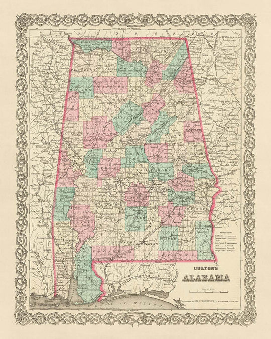
Immerse yourself in the rich history of the United States with this meticulously detailed map of Alabama, crafted by the esteemed mapmaker J. H. Colton in 1855. This remarkable piece is a testament to the artistry and precision that Colton brought to his craft, a representation of his status as one of the finest American mapmakers of his era.
This map provides a unique snapshot of Alabama at a time when the United States was still in its infancy. The year 1855 was a time of immense change and growth, and this map captures the spirit of that era. It provides a fascinating glimpse into the past, showing the layout of the state as it was over 150 years ago. At this time, many of the settlements we know today had not yet been founded, and the names and borders of those that had may have changed significantly since then.
The map features the five most notable settlements in Alabama at the time: Mobile, Montgomery, Huntsville, Tuscaloosa, and Selma. Each of these settlements has its own rich history, and their depiction on this map provides a fascinating insight into their early days. Whether you're a history enthusiast, a map collector, or simply someone who appreciates fine craftsmanship, this map is a must-have addition to your collection.
This map is not just a piece of history, but a work of art. The attention to detail and the precision with which it was created are a testament to Colton's skill and dedication. It's a tangible connection to the past, a window into a time when the United States was still finding its feet and shaping its identity.
From the intricate detailing of the settlements to the carefully marked borders, every aspect of this map has been meticulously crafted. It's a celebration of the art of cartography, a tribute to the skill and precision that went into creating such detailed maps at a time when technology was far less advanced than it is today.
This old map of Alabama is more than just a piece of history - it's a piece of art, a testament to the skill and dedication of one of America's finest mapmakers, and a fascinating insight into the early days of some of Alabama's most notable settlements.
Settlements in Alabama
- Mobile (1702): Known as the oldest city in Alabama, Mobile was originally founded by French colonists. It was a key trading center due to its strategic location on the Mobile River.
- Montgomery (1819): Established as the capital of Alabama in 1846, Montgomery played a pivotal role in the Confederacy during the Civil War.
- Huntsville (1805): Known as "The Rocket City" for its contributions to U.S. space missions, Huntsville was originally a cotton trading center.
- Tuscaloosa (1819): Home to the University of Alabama, Tuscaloosa served as the state's capital from 1826 to 1846.
- Selma (1820): Selma played a significant role in the Civil Rights Movement. It was a center for the Confederate military during the Civil War.
- Auburn (1832): Auburn is known for Auburn University, one of the largest universities in the South.
- Florence (1818): Florence is the oldest city in the northwestern part of Alabama and was a significant commercial center during the 19th century.
- Decatur (1820): Known as "The River City," Decatur was a key transportation hub due to its location along the Tennessee River.
- Gadsden (1846): Named after Colonel James Gadsden, who engineered the Gadsden Purchase, it was a significant industrial center.
- Madison (1869): Known for its historic downtown district, Madison has preserved many of its original buildings from the 19th century.
- Athens (1818): Named after the ancient city of Athens, Greece, it's known for its antebellum architecture.
- Cullman (1873): Founded by German immigrants, Cullman is known for its Oktoberfest celebration.
- Talladega (1835): Known for the Talladega Superspeedway, one of the most famous NASCAR racetracks.
- Scottsboro (1869): Known for the infamous Scottsboro Boys trial in the 1930s.
- Fort Payne (1889): Known for its role in the 1880s boom period of the hosiery industry.
- Eufaula (1832): Known for its historic downtown which is part of the Eufaula Historic District.
- Jacksonville (1833): Home to Jacksonville State University, it was a major center of trade and law enforcement during the 19th century.
- Wetumpka (1834): Known for the Wetumpka crater, a possible meteorite impact site.
- Tuscumbia (1820): Known as the birthplace of Helen Keller.
- Prattville (1839): Known as "The Fountain City" due to the numerous artesian wells in the area.
Native American Tribes
- Creek Confederacy: A union of several tribes, including the Muscogee, Alabama, and others.
- Cherokee Nation: Occupied the northeastern region of Alabama.
- Choctaw Nation: Occupied the southwestern region of Alabama.
- Chickasaw Nation: Occupied the northwestern region of Alabama.
Natural Attractions
- Tennessee River: The largest tributary of the Ohio River, it's a popular spot for boating and fishing.
- Alabama River: Known for its diverse wildlife and scenic beauty.
- Mobile Bay: A significant biodiversity hotspot, it's home to many species of fish and birds.
- Little River Canyon: Known as the "Grand Canyon of the East," it's a popular spot for hiking and camping.
- Bankhead National Forest: Known for its scenic beauty and recreational opportunities.
Historical Events
- Creek War (1813-1814): A major conflict in the American Southeast during the War of 1812.
- Alabama Gold Rush (1829): A significant gold rush in the early 19th century, centered around the towns of Jacksonville and Talladega.
- Indian Removal Act (1830): Led to the forced removal of Native American tribes from Alabama.
- Alabama Statehood (1819): Alabama became the 22nd state of the United States.
Please double check the images to make sure that a specific town or place is shown on this map. You can also get in touch and ask us to check the map for you.
This map looks great at all sizes: 12x16in (30.5x41cm), 16x20in (40.5x51cm), 18x24in (45.5x61cm), 24x30in (61x76cm), 32x40in (81.5x102cm), 40x50in (102x127cm), 48x60in (122x153cm) and 56x70in (142x178cm), but it looks even better when printed large.
I can create beautiful, large prints of this map up to 70in (178cm). Please get in touch if you're looking for larger, customised or different framing options.
The model in the listing images is holding the 16x20in (40.5x51cm) version of this map.
The fifth listing image shows an example of my map personalisation service.
If you’re looking for something slightly different, check out my main collection of USA and North America maps.
Please contact me to check if a certain location, landmark or feature is shown on this map.
This would make a wonderful birthday, Christmas, Father's Day, work leaving, anniversary or housewarming gift for someone from the areas covered by this map.
This map is available as a giclée print on acid free archival matte paper, or you can buy it framed. The frame is a nice, simple black frame that suits most aesthetics. Please get in touch if you'd like a different frame colour or material. My frames are glazed with super-clear museum-grade acrylic (perspex/acrylite), which is significantly less reflective than glass, safer, and will always arrive in perfect condition.
This map is also available as a float framed canvas, sometimes known as a shadow gap framed canvas or canvas floater. The map is printed on artist's cotton canvas and then stretched over a handmade box frame. We then "float" the canvas inside a wooden frame, which is available in a range of colours (black, dark brown, oak, antique gold and white). This is a wonderful way to present a map without glazing in front. See some examples of float framed canvas maps and explore the differences between my different finishes.
For something truly unique, this map is also available in "Unique 3D", our trademarked process that dramatically transforms the map so that it has a wonderful sense of depth. We combine the original map with detailed topography and elevation data, so that mountains and the terrain really "pop". For more info and examples of 3D maps, check my Unique 3D page.
For most orders, delivery time is about 3 working days. Personalised and customised products take longer, as I have to do the personalisation and send it to you for approval, which usually takes 1 or 2 days.
Please note that very large framed orders usually take longer to make and deliver.
If you need your order to arrive by a certain date, please contact me before you order so that we can find the best way of making sure you get your order in time.
I print and frame maps and artwork in 23 countries around the world. This means your order will be made locally, which cuts down on delivery time and ensures that it won't be damaged during delivery. You'll never pay customs or import duty, and we'll put less CO2 into the air.
All of my maps and art prints are well packaged and sent in a rugged tube if unframed, or surrounded by foam if framed.
I try to send out all orders within 1 or 2 days of receiving your order, though some products (like face masks, mugs and tote bags) can take longer to make.
If you select Express Delivery at checkout your order we will prioritise your order and send it out by 1-day courier (Fedex, DHL, UPS, Parcelforce).
Next Day delivery is also available in some countries (US, UK, Singapore, UAE) but please try to order early in the day so that we can get it sent out on time.
My standard frame is a gallery style black ash hardwood frame. It is simple and quite modern looking. My standard frame is around 20mm (0.8in) wide.
I use super-clear acrylic (perspex/acrylite) for the frame glass. It's lighter and safer than glass - and it looks better, as the reflectivity is lower.
Six standard frame colours are available for free (black, dark brown, dark grey, oak, white and antique gold). Custom framing and mounting/matting is available if you're looking for something else.
Most maps, art and illustrations are also available as a framed canvas. We use matte (not shiny) cotton canvas, stretch it over a sustainably sourced box wood frame, and then 'float' the piece within a wood frame. The end result is quite beautiful, and there's no glazing to get in the way.
All frames are provided "ready to hang", with either a string or brackets on the back. Very large frames will have heavy duty hanging plates and/or a mounting baton. If you have any questions, please get in touch.
See some examples of my framed maps and framed canvas maps.
Alternatively, I can also supply old maps and artwork on canvas, foam board, cotton rag and other materials.
If you want to frame your map or artwork yourself, please read my size guide first.
Alcune delle mie vecchie mappe sono ora disponibili come tele incorniciate. Per favore contattami se desideri ordinare una dimensione che non è disponibile nel mio negozio.
Le vecchie mappe su tela sono un'alternativa interessante alle mappe incorniciate in modo convenzionale. A seconda del tuo gusto personale e dell'arredamento della stanza, le mappe su tela possono "risaltare" un po' di più rispetto a una mappa incorniciata.
My maps are extremely high quality reproductions of original maps.
I source original, rare maps from libraries, auction houses and private collections around the world, restore them at my London workshop, and then use specialist giclée inks and printers to create beautiful maps that look even better than the original.
My maps are printed on acid-free archival matte (not glossy) paper that feels very high quality and almost like card. In technical terms the paper weight/thickness is 10mil/200gsm. It's perfect for framing.
I print with Epson ultrachrome giclée UV fade resistant pigment inks - some of the best inks you can find.
I can also make maps on canvas, cotton rag and other exotic materials.
Learn more about The Unique Maps Co.
Map personalisation
If you're looking for the perfect anniversary or housewarming gift, I can personalise your map to make it truly unique. For example, I can add a short message, or highlight an important location, or add your family's coat of arms.
The options are almost infinite. Please see my map personalisation page for some wonderful examples of what's possible.
To order a personalised map, select "personalise your map" before adding it to your basket.
Get in touch if you're looking for more complex customisations and personalisations.
Map ageing
I have been asked hundreds of times over the years by customers if they could buy a map that looks even older.
Well, now you can, by selecting Aged before you add a map to your basket.
All the product photos you see on this page show the map in its Original form. This is what the map looks like today.
If you select Aged, I will age your map by hand, using a special and unique process developed through years of studying old maps, talking to researchers to understand the chemistry of aging paper, and of course... lots of practice!
If you're unsure, stick to the Original colour of the map. If you want something a bit darker and older looking, go for Aged.
Se non sei soddisfatto del tuo ordine per qualsiasi motivo, contattami per un rimborso senza problemi. Si prega di consultare la nostra politica di reso e rimborso per ulteriori informazioni.
Sono molto sicuro che ti piacerà la tua mappa restaurata o la stampa d'arte. Lo faccio dal 1984. Sono un venditore Etsy a 5 stelle. Ho venduto decine di migliaia di mappe e stampe d'arte e ho oltre 5.000 recensioni reali a 5 stelle.
Utilizzo un processo unico per restaurare mappe e opere d'arte che richiede molto tempo e lavoro. Trovare le mappe e le illustrazioni originali può richiedere mesi. Utilizzo tecnologia all'avanguardia e incredibilmente costosa per scannerizzare e restaurarle. Di conseguenza, garantisco che le mie mappe e stampe d'arte siano superiori alle altre - ecco perché posso offrire un rimborso senza problemi.
Quasi tutte le mie mappe e stampe d'arte sembrano fantastiche a grandi dimensioni (200 cm, 6,5 piedi+) e posso anche incorniciarle e consegnarle a te, tramite un corriere speciale per oggetti di grandi dimensioni. Contattami per discutere delle tue esigenze specifiche.
Or try searching for something!


