


Antica carta nautica di Bali, Lombok, Flores, Sumba e Timor di Laurie & Whittle, 1798: Giava, Mare di Banda, Spedizioni

-
![]() Handmade locally in the EU
Handmade locally in the EU
-
Christmas delivery: check the deadline
Free delivery in 3-4 days
Your map should be delivered in 3-4 working days with free delivery, worldwide.
Unframed maps should arrive by Christmas with free delivery. Please use Express Delivery at checkout for framed maps.
We make maps by hand locally in 23 countries, including the EU
![]() . If you're buying a gift for someone in another country, we will make the map locally to them.
. If you're buying a gift for someone in another country, we will make the map locally to them.You will never pay import tax or customs duty.
Check the Christmas delivery guide for order deadlines. Delivery times are starting to slow down, and will continue to slow down towards Christmas.
Express delivery is available at checkout which can reduce the delivery time to 1-2 days.
Please note that personalised maps, and larger framed maps, can take longer to produce and deliver.
If you need your order to arrive by a certain date, contact me and we can discuss your options.
-
90 day money back guarantee
ⓘ
90 giorni per restituire e ricevere un rimborso
I prodotti possono essere restituiti entro 90 giorni per un rimborso completo, o cambio con un altro prodotto.
Per articoli personalizzati e su misura, potremmo offrirti un credito in negozio o una carta regalo non scadente, poiché non possiamo rivendere ordini personalizzati.
Se hai domande, contattaci. Per ulteriori informazioni, consulta la nostra politica di restituzione e cambio.

My maps are rare, museum-grade, restored old maps sourced from libraries, auction houses and private collections across the globe.
Framing & free personalisation available
1. Select your size
2. Frame & personalise your map
There is limited framing & personalisation capacity available. Order by 10am tomorrow for Christmas delivery.


Gift message & custom finish

If you want to add a gift message, or a finish (jigsaw, aluminium board, etc.) that is not available here, please request it in the "order note" when you check out.
Every order is custom made, so if you need the size adjusted slightly, or printed on an unusual material, just let us know. We've done thousands of custom orders over the years, so there's (almost) nothing we can't manage.
You can also contact us before you order, if you prefer!

- Handmade locally. No import duty or tax
- FREE Delivery by Christmas
- Love it or your money back (90 days)
- Questions? WhatsApp me any time
Own a piece of history
5,000+ 5 star reviews


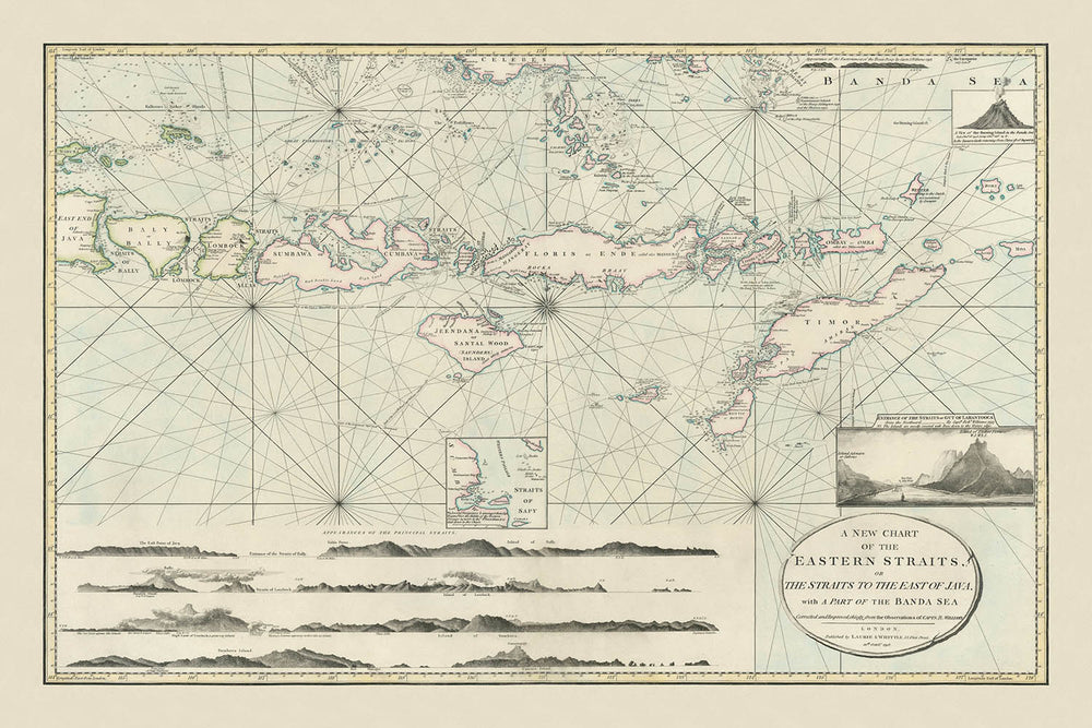
Scopri il mondo affascinante dell'esplorazione marittima della fine del XVIII secolo con "Una Nuova Carta degli Stretto Orientali, o gli Stretto a Est di Giava, con una Parte del Mare di Banda." Realizzata dai rinomati cartografi Laurie & Whittle nel 1798, questa carta nautica offre uno sguardo dettagliato sulle dinamiche marittime degli Stretto Orientali. Sottolineando la geografia intricata di regioni come Bali, Flores e il Mare di Banda, la mappa funge da testimonianza della competenza navigazionale dell'epoca e delle complessità dei viaggi marittimi.
La carta è un tesoro di viaggi storici, caratterizzata dai percorsi di spedizioni rinomate come quelle del Capitano Cook e del leggendario bucaniere William Dampier. Questi percorsi, tracciati con meticolosità, forniscono un'affascinante intuizione sulle sfide e i trionfi degli esploratori mentre navigavano in queste acque pericolose. L'inclusione di tali viaggi notevoli sottolinea l'importanza della mappa come documento storico, catturando lo spirito di avventura e scoperta che ha definito l'epoca.
L'attenzione ai dettagli di Laurie & Whittle è evidente nel design della mappa, che include viste in inserto e profili costieri che arricchiscono la comprensione del pubblico sulla topografia della regione. La rappresentazione degli Stretto di Larantooca e di un'isola vulcanica nel Mare di Banda aggiunge strati di intrigo, invitando il pubblico a esplorare più a fondo le caratteristiche geografiche e geologiche dell'area. Questi elementi, combinati con gli strumenti di navigazione della mappa come rose dei venti e sonde, la rendono una risorsa preziosa per comprendere le tecniche di navigazione storica.
La mappa evidenzia anche la natura in evoluzione della conoscenza geografica durante il periodo, come si vede nelle discrepanze tra diverse fonti storiche. Ad esempio, il riferimento alla descrizione olandese dell'Isola di Wetter, che contrasta con il racconto di Dampier, offre uno sguardo sulle complessità e le sfide affrontate dai cartografi dell'epoca. Questo aspetto della mappa non solo ne aumenta il valore storico, ma invita anche a riflettere sui progressi della scienza cartografica.
In sostanza, questa mappa è più di un semplice strumento di navigazione; è una finestra su un'epoca passata di esplorazione e scoperta. La sua robusta rappresentazione di regioni marittime chiave, stratificata con riferimenti a viaggi importanti e dispute geografiche, ne assicura il valore duraturo come istantanea dell'esplorazione marittima della fine del XVIII secolo. Che tu sia un appassionato di storia, un amante della cartografia o un amante della tradizione marittima, questa carta promette di essere un'aggiunta preziosa alla tua collezione.
Luoghi notevoli su questa mappa
- Giava: Stretto orientali e regioni costiere.
- Bali: Contrassegnato con dettagli chiave degli stretti e costieri.
- Flores: Rappresentazione dettagliata dell'isola e delle sue caratteristiche costiere.
- Mare di Banda: Parzialmente mostrato con dettagli marittimi.
- Stretto di Larantooca: Rappresentazione in inserto dell'ingresso.
- Stretti di Sapy: Tracciamento del Passaggio Occidentale.
- Timor: Regioni costiere e dettagli navigazionali.
- Vulcano nel Mare di Banda: Rappresentazione di un'isola in fiamme.
- Isola di Wetter: Nota per discrepanze storiche.
- Profili costieri: Varie viste dettagliate di stretti e isole.
Caratteristiche & Luoghi di Interesse
- Area geografica: Copre gli Strett di Est, inclusi Bali, Flores e parti del Mare di Banda.
- Rotte nautiche: Tracce di viaggi storici, come quelli del Capitano Cook e di William Dampier.
- Viste in dettaglio: Rappresentazioni degli Strett di Larantooca e un'isola vulcanica nel Mare di Banda.
- Profili costieri: Viste costiere dettagliate di strati e isole chiave.
- Strumenti di navigazione: Rose dei venti, misurazioni in braccia, e canali d'acqua.
- Attività vulcanica: Illustrazione di un'isola in fiamme (vulcano) nel Mare di Banda.
- Tracce di spedizioni: Viaggi notevoli come "Il Lord Holland" e "L'Earl di Mansfield."
- Dinamiche marittime: Rappresentazione di rotte marittime complesse e dinamiche della regione.
Contesto storico e di design
- Nome della mappa: Una Nuova Carta degli Strett di Est, o gli Strett a Est di Giava, con una parte del Mare di Banda.
- Data di creazione: 12 ottobre 1798.
- Cartografo/Editore: Laurie & Whittle, noti per le carte nautiche dettagliate e accurate.
- Temi e argomenti: Navigazione marittima, spedizioni nautiche storiche, dettagli geografici.
- Design/Stile: Carta nautica con profili costieri dettagliati, viste in dettaglio e strumenti di navigazione.
- Significato storico: Approfondimento sull'esplorazione marittima e comprensione geografica della fine del XVIII secolo.
Si prega di controllare attentamente le immagini per assicurarsi che una specifica città o luogo sia mostrato su questa mappa. Puoi anche contattarci e chiedere di controllare la mappa per te.
Questa mappa appare fantastica in ogni dimensione, ma consiglio sempre di optare per una dimensione più grande se hai spazio. In questo modo puoi facilmente distinguere tutti i dettagli.
Questa mappa appare incredibile in dimensioni fino a 100in (250cm). Se stai cercando una mappa più grande, per favore contattaci.
Si prega di notare: le etichette su questa mappa sono difficili da leggere se ordini una mappa che è 20in (50cm) o più piccola. La mappa è comunque molto attraente, ma se desideri leggere facilmente la mappa, ti preghiamo di acquistare una dimensione più grande.
Il modello nelle immagini dell'elenco tiene la versione 24x36in (60x90cm) di questa mappa.
La quinta immagine dell'elenco mostra un esempio del mio servizio di personalizzazione della mappa.
Se stai cercando qualcosa di leggermente diverso, dai un'occhiata alla mia collezione delle migliori vecchie mappe per vedere se qualcosa attira la tua attenzione.
Per favore contattami per controllare se una certa posizione, punto di riferimento o caratteristica è mostrata su questa mappa.
Questo sarebbe un meraviglioso regalo per un compleanno, Natale, Festa del Papà, addio al lavoro, anniversario o inaugurazione della casa per qualcuno delle aree coperte da questa mappa.
Questa mappa è disponibile come stampa giclée su carta opaca archiviata senza acidi, oppure puoi acquistarla incorniciata. La cornice è una semplice cornice nera che si adatta alla maggior parte degli stili. Per favore contattaci se desideri un colore o un materiale della cornice diverso. Le mie cornici sono dotate di un vetro acrilico super chiaro di qualità museale (perspex/acrylite), che è significativamente meno riflettente del vetro, più sicuro, e arriverà sempre in perfette condizioni.
This map is also available as a float framed canvas, sometimes known as a shadow gap framed canvas or canvas floater. The map is printed on artist's cotton canvas and then stretched over a handmade box frame. We then "float" the canvas inside a wooden frame, which is available in a range of colours (black, dark brown, oak, antique gold and white). This is a wonderful way to present a map without glazing in front. See some examples of float framed canvas maps and explore the differences between my different finishes.
For something truly unique, this map is also available in "Unique 3D", our trademarked process that dramatically transforms the map so that it has a wonderful sense of depth. We combine the original map with detailed topography and elevation data, so that mountains and the terrain really "pop". For more info and examples of 3D maps, check my Unique 3D page.
For most orders, delivery time is about 3 working days. Personalised and customised products take longer, as I have to do the personalisation and send it to you for approval, which usually takes 1 or 2 days.
Please note that very large framed orders usually take longer to make and deliver.
If you need your order to arrive by a certain date, please contact me before you order so that we can find the best way of making sure you get your order in time.
I print and frame maps and artwork in 23 countries around the world. This means your order will be made locally, which cuts down on delivery time and ensures that it won't be damaged during delivery. You'll never pay customs or import duty, and we'll put less CO2 into the air.
All of my maps and art prints are well packaged and sent in a rugged tube if unframed, or surrounded by foam if framed.
I try to send out all orders within 1 or 2 days of receiving your order, though some products (like face masks, mugs and tote bags) can take longer to make.
If you select Express Delivery at checkout your order we will prioritise your order and send it out by 1-day courier (Fedex, DHL, UPS, Parcelforce).
Next Day delivery is also available in some countries (US, UK, Singapore, UAE) but please try to order early in the day so that we can get it sent out on time.
My standard frame is a gallery style black ash hardwood frame. It is simple and quite modern looking. My standard frame is around 20mm (0.8in) wide.
I use super-clear acrylic (perspex/acrylite) for the frame glass. It's lighter and safer than glass - and it looks better, as the reflectivity is lower.
Six standard frame colours are available for free (black, dark brown, dark grey, oak, white and antique gold). Custom framing and mounting/matting is available if you're looking for something else.
Most maps, art and illustrations are also available as a framed canvas. We use matte (not shiny) cotton canvas, stretch it over a sustainably sourced box wood frame, and then 'float' the piece within a wood frame. The end result is quite beautiful, and there's no glazing to get in the way.
All frames are provided "ready to hang", with either a string or brackets on the back. Very large frames will have heavy duty hanging plates and/or a mounting baton. If you have any questions, please get in touch.
See some examples of my framed maps and framed canvas maps.
Alternatively, I can also supply old maps and artwork on canvas, foam board, cotton rag and other materials.
If you want to frame your map or artwork yourself, please read my size guide first.
Alcune delle mie vecchie mappe sono ora disponibili come tele incorniciate. Per favore contattami se desideri ordinare una dimensione che non è disponibile nel mio negozio.
Le vecchie mappe su tela sono un'alternativa interessante alle mappe incorniciate in modo convenzionale. A seconda del tuo gusto personale e dell'arredamento della stanza, le mappe su tela possono "risaltare" un po' di più rispetto a una mappa incorniciata.
My maps are extremely high quality reproductions of original maps.
I source original, rare maps from libraries, auction houses and private collections around the world, restore them at my London workshop, and then use specialist giclée inks and printers to create beautiful maps that look even better than the original.
My maps are printed on acid-free archival matte (not glossy) paper that feels very high quality and almost like card. In technical terms the paper weight/thickness is 10mil/200gsm. It's perfect for framing.
I print with Epson ultrachrome giclée UV fade resistant pigment inks - some of the best inks you can find.
I can also make maps on canvas, cotton rag and other exotic materials.
Learn more about The Unique Maps Co.
Map personalisation
If you're looking for the perfect anniversary or housewarming gift, I can personalise your map to make it truly unique. For example, I can add a short message, or highlight an important location, or add your family's coat of arms.
The options are almost infinite. Please see my map personalisation page for some wonderful examples of what's possible.
To order a personalised map, select "personalise your map" before adding it to your basket.
Get in touch if you're looking for more complex customisations and personalisations.
Map ageing
I have been asked hundreds of times over the years by customers if they could buy a map that looks even older.
Well, now you can, by selecting Aged before you add a map to your basket.
All the product photos you see on this page show the map in its Original form. This is what the map looks like today.
If you select Aged, I will age your map by hand, using a special and unique process developed through years of studying old maps, talking to researchers to understand the chemistry of aging paper, and of course... lots of practice!
If you're unsure, stick to the Original colour of the map. If you want something a bit darker and older looking, go for Aged.
Se non sei soddisfatto del tuo ordine per qualsiasi motivo, contattami per un rimborso senza problemi. Si prega di consultare la nostra politica di reso e rimborso per ulteriori informazioni.
Sono molto sicuro che ti piacerà la tua mappa restaurata o la stampa d'arte. Lo faccio dal 1984. Sono un venditore Etsy a 5 stelle. Ho venduto decine di migliaia di mappe e stampe d'arte e ho oltre 5.000 recensioni reali a 5 stelle.
Utilizzo un processo unico per restaurare mappe e opere d'arte che richiede molto tempo e lavoro. Trovare le mappe e le illustrazioni originali può richiedere mesi. Utilizzo tecnologia all'avanguardia e incredibilmente costosa per scannerizzare e restaurarle. Di conseguenza, garantisco che le mie mappe e stampe d'arte siano superiori alle altre - ecco perché posso offrire un rimborso senza problemi.
Quasi tutte le mie mappe e stampe d'arte sembrano fantastiche a grandi dimensioni (200 cm, 6,5 piedi+) e posso anche incorniciarle e consegnarle a te, tramite un corriere speciale per oggetti di grandi dimensioni. Contattami per discutere delle tue esigenze specifiche.
Or try searching for something!


