


Mappa antica della Barbiera di Visscher, 1690: Barbari, Algeri, Tunisi, Il Cairo, Isole Canarie, Deserto del Sahara
20% di sconto su 2 — 33% di sconto su 3
Aggiungi qualsiasi due articoli idonei al tuo carrello per ricevere 20% di sconto. Aggiungi un terzo e sarà gratuito (equivalente a 33% di sconto quando acquisti tre).
Nessun codice necessario — l'offerta si applica automaticamente al checkout.
Valido su tutte le mappe standard e le stampe d'arte fine. Puoi mescolare e abbinare qualsiasi design.
Se desideri spedire articoli a più indirizzi, ti preghiamo di contattarci prima di effettuare il tuo ordine.
Le commissioni personalizzate e su misura sono escluse.
Contattaci se hai domande
-
![]() Handmade locally in the EU
Handmade locally in the EU

-
Free delivery 2-3 days ⓘ
Free delivery in 2-3 days
Your map should be delivered in 2-3 working days with free delivery, worldwide.
We make maps by hand locally in 23 countries, including the EU
![]() . If you're buying a gift for someone in another country, we will make the map locally to them.
. If you're buying a gift for someone in another country, we will make the map locally to them.You will never pay import tax or customs duty.
Express delivery is available at checkout which can reduce the delivery time to 1-2 days.
Please note that personalised maps, and larger framed maps, can take longer to produce and deliver.
If you need your order to arrive by a certain date, contact me and we can discuss your options.
-
Complimentary gifting & design advice
ⓘ
Complimentary gifting & design advice
Available almost 24/7 on WhatsApp and email — we usually reply within minutes. We can help you:
- Choose a perfectly personalised gift
- Send a digital gift preview to the recipient
- Pick the ideal size for your wall
- Select the right finish and frame
Quick, friendly advice so you can order with confidence.
For last minute gifts, consider buying a digital gift card. We have over 5,000 maps and art prints to choose from.
-
90-day returns & 5-year guarantee
ⓘ
90 giorni per restituire e ricevere un rimborso
I prodotti possono essere restituiti entro 90 giorni per un rimborso completo, o cambio con un altro prodotto.
Per articoli personalizzati e su misura, potremmo offrirti un credito in negozio o una carta regalo non scadente, poiché non possiamo rivendere ordini personalizzati.
Se hai domande, contattaci. Per ulteriori informazioni, consulta la nostra politica di restituzione e cambio.

This is a museum-grade archival print from the original 1690 map — restored in our workshop and made to order on 220gsm archival matte paper or 400gsm artist's cotton canvas with pigment inks.
Professional framing & free personalisation available.
1. Choose a size
2. Frame & personalise your map
Make your map unique with framing, hand-drawn customisation, vintage ageing, pop art text, unique 3D styling and more.


Gift message & custom finish

If you want to add a gift message, or a finish (jigsaw, aluminium board, etc.) that is not available here, please request it in the "order note" when you check out.
Every order is custom made, so if you need the size adjusted slightly, or printed on an unusual material, just let us know. We've done thousands of custom orders over the years, so there's (almost) nothing we can't manage.
You can also contact us before you order, if you prefer!

- Handmade locally. No import duty or tax
- FREE worldwide delivery
- 90-day returns & 5-year product guarantee
- Questions? WhatsApp me any time
Own a piece of history
7,000+ 5 star reviews


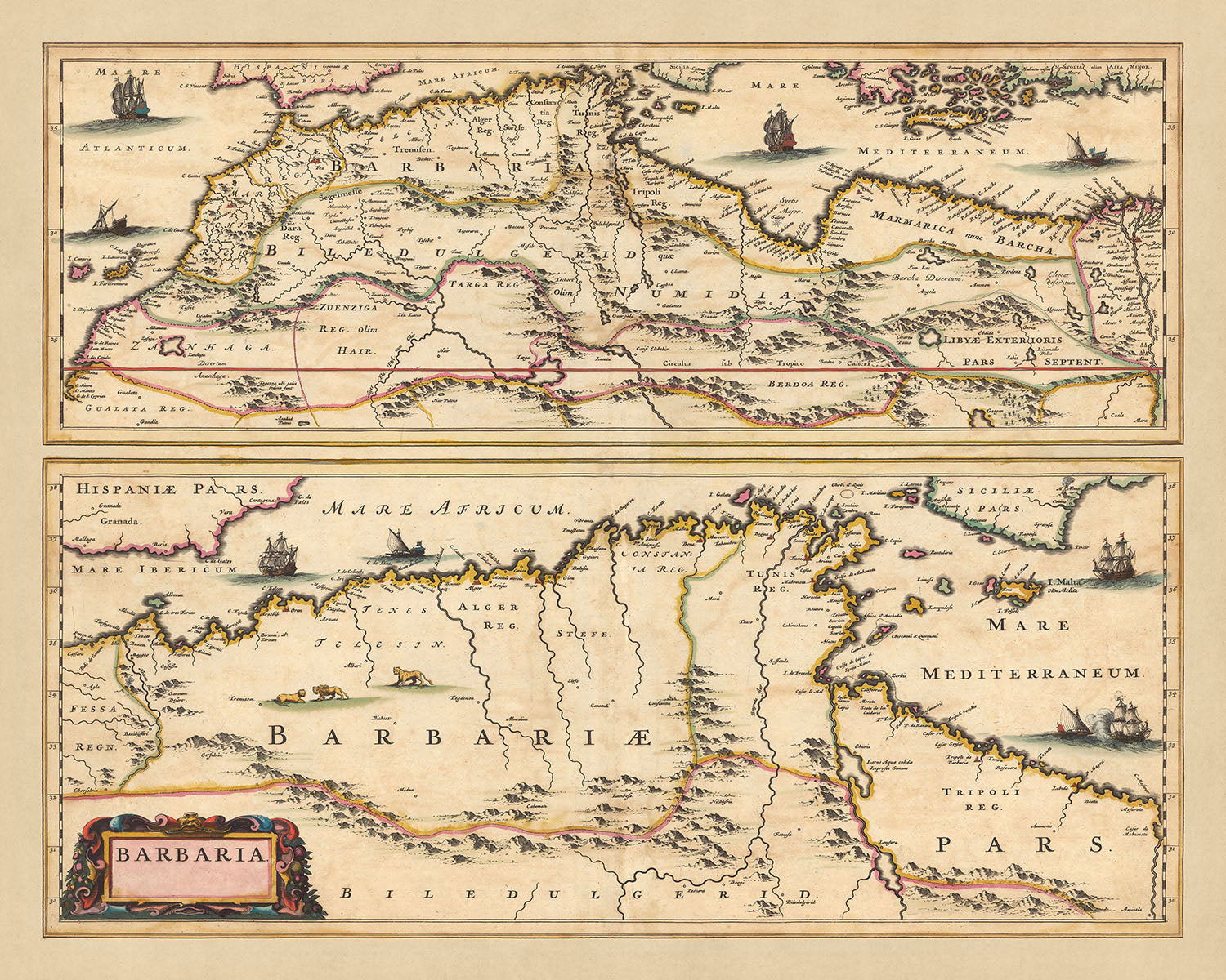
Immergiti nel mondo del passato con la mappa 'Barbaria', un affascinante reperto storico risalente al 1690. Questa mappa, meticolosamente realizzata da Nicolaes Visscher II, offre una vista dettagliata della Barbary, una regione che comprende l'area più ampia dell'odierna Nord Africa. 'Barbaria', che si traduce in 'Barbary' in inglese, fornisce un chiaro indicativo del focus geografico di questa mappa. Come prodotto dell'età dell'oro olandese della cartografia, rappresenta una testimonianza dell'abilità straordinaria e della precisione dei suoi creatori, offrendo una finestra nel passato che è tanto educativa quanto affascinante.
La mappa 'Barbaria' è più di una semplice rappresentazione geografica. È un documento storico che rivela le divisioni politiche del suo tempo, fornendo un vivido quadro del passato. Da Algeri a Tunisi, da Il Cairo alle Isole Canarie, ogni città e punto di riferimento racconta una storia del panorama politico e culturale della fine del XVII secolo. La mappa offre anche una rappresentazione dettagliata del deserto del Sahara, uno dei deserti più grandi e caldi del mondo.
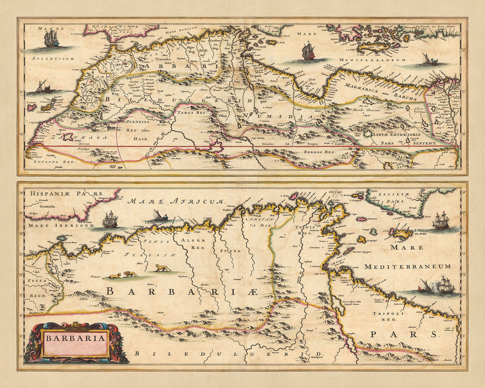
La mappa 'Barbaria' mette in mostra la bellezza della cartografia e l'arte dei suoi creatori. Ogni mappa incisa a mano e colorata sulla pagina serve come testimonianza dell'abilità del cartografo e della sua attenzione ai dettagli. Copre il Nord Africa e il Mediterraneo, con il pannello superiore che mostra quasi l'intera costa settentrionale dell'Africa, e il pannello inferiore che fornisce una rappresentazione dettagliata dell'area nelle vicinanze dell'odierna Algeri. La mappa mostra confini politici, città, paesi, corsi d'acqua, canali, punti di riferimento, fauna selvatica e montagne, tutti resi vivi attraverso il cartiglio decorativo del titolo e il rilievo pittorico.
La mappa 'Barbaria' è un pezzo di storia, un'opera d'arte e uno strumento per l'istruzione. Fornisce una prospettiva unica sul mondo così com'era conosciuto nel 1690, offrendo approfondimenti sulle realtà politiche, geografiche e culturali dell'epoca. Che tu sia un appassionato di storia, un amante della cartografia, o semplicemente qualcuno che apprezza la bellezza delle vecchie mappe, la mappa 'Barbaria' saprà sicuramente catturare il tuo interesse e accendere la tua immaginazione.
Alcune delle località significative mostrate su questa mappa:
Costiera di Barbary
- Algeri: Conosciuta come El Djazaïr in arabo, era la città più grande e capitale del Regno Ottomano di Algeri, un importante centro dei pirati di Barbary.
- Tunisi: Capitale del Beylik Ottomano di Tunisi, era un importante centro di commercio e cultura nel Mediterraneo.
- Tripoli: Capitale della dinastia ottomana Karamanli, era un importante porto e centro dei pirati di Barbary.
- Bengasi: Una città importante nella provincia ottomana di Tripolitania, era un hub di commercio e cultura.
- Derna: Una chiave città portuale nella provincia ottomana di Cirenaica, era nota per il suo vivace mercato.
Egitto
- Il Cairo: Conosciuto come Al-Qāhirah, era la capitale dell'Eyalet Ottomano d'Egitto e la città più grande d'Africa.
- Alessandria: Conosciuta come Al-Iskandariyya, era una grande città portuale e centro culturale nell'Eyalet Ottomano d'Egitto.
- Damietta: Conosciuta come Damiyat, era un porto chiave e centro commerciale nell'Eyalet Ottomano d'Egitto.
- Mansoura: Conosciuta come Al-Mansurah, era una città importante nell'Eyalet Ottomano d'Egitto, nota per la sua industria tessile.
- Rosetta: Conosciuta come Rashid, era una chiave città portuale nell'Eyalet Ottomano d'Egitto.
Isole Canarie
- Santa Cruz de Tenerife: Conosciuta come Santa Cruz, era la città più grande delle Isole Canarie, una colonia spagnola.
- Las Palmas: Conosciuta come Las Palmas de Gran Canaria, era una città importante delle Isole Canarie, una colonia spagnola.
- San Cristóbal de La Laguna: Conosciuta come La Laguna, era una città chiave delle Isole Canarie, una colonia spagnola.
- Arrecife: Una città portuale chiave delle Isole Canarie, una colonia spagnola.
- Puerto del Rosario: Conosciuta come Puerto Cabras, era una città importante delle Isole Canarie, una colonia spagnola.
Deserto del Sahara
- Timbuktu: Una città chiave nell'Impero Songhai, era un importante centro di cultura e studio islamico.
- Gao: Capitale dell'Impero Songhai, era un importante centro di commercio e cultura.
- Djenne: Una città chiave nell'Impero Songhai, era nota per la sua Grande Moschea, un sito patrimonio dell'umanità dell'UNESCO.
- Agadez: Una città chiave nel Sultanato di Agadez, era un importante centro del commercio trans-sahariano.
- Ouargla: Una città chiave nel Regno Ottomano di Algeri, era un importante centro del commercio trans-sahariano.
Fenomeni Naturali Notevoli
- Fiume Nilo: Il fiume più lungo del mondo, era un'arteria chiave per il commercio e il trasporto.
- Monti Atlante: Una grande catena montuosa nel Nord Africa, è conosciuta per la sua flora e fauna uniche.
- Deserto del Sahara: Il più grande deserto caldo del mondo, è noto per le sue vaste dune di sabbia e gli ecosistemi unici.
- Mar Mediterraneo: Un mare importante connesso all'Oceano Atlantico, era una rotta chiave per il commercio e l'esplorazione.
- Stretto di Gibilterra: Uno stretto stretto che collega l'Oceano Atlantico al Mar Mediterraneo, era una posizione strategica chiave per le potenze navali.
Eventi Storici Notevoli (1600-1690)
- L'Espulsione dei Moriscos (1609-1614): Un evento importante nella storia spagnola, coinvolse la conversione forzata e l'espulsione dei Moriscos (musulmani che erano stati convertiti forzatamente al cristianesimo) dalla Spagna.
- La Battaglia di Ksar El Kebir (1578): Una battaglia decisiva nella storia marocchina, portò alla morte del re Sebastiano di Portogallo e a una crisi di successione in Portogallo.
- La Guerra Cretese (1645–1669): Un conflitto importante tra l'Impero Ottomano e la Repubblica Veneziana, portò alla conquista di Creta da parte degli Ottomani.
Si prega di controllare attentamente le immagini per assicurarsi che una città o un luogo specifico sia mostrato su questa mappa. Puoi anche contattarci e chiederci di controllare la mappa per te.
Questa mappa appare fantastica in tutte le dimensioni: 12x16in (30.5x41cm), 16x20in (40.5x51cm), 18x24in (45.5x61cm), 24x30in (61x76cm), 32x40in (81.5x102cm), 40x50in (102x127cm), 48x60in (122x153cm) e 56x70in (142x178cm), ma sembra ancora meglio quando stampata in grande.
Posso creare bellissime stampe grandi di questa mappa fino a 90in (229cm). Si prega di contattarmi se stai cercando opzioni di incorniciatura più grandi, personalizzate o diverse.
Il modello nelle immagini dell'annuncio tiene in mano la versione 16x20in (40.5x51cm) di questa mappa.
La quinta immagine dell'annuncio mostra un esempio del mio servizio di personalizzazione della mappa.
Se stai cercando qualcosa di leggermente diverso, dai un'occhiata alla mia collezione delle migliori vecchie mappe d'Europa e delle città europee per vedere se qualcosa attira la tua attenzione.
Si prega di contattarmi per verificare se una certa posizione, punto di riferimento o caratteristica è mostrata su questa mappa.
Questo sarebbe un meraviglioso regalo per un compleanno, Natale, Festa del Papà, un addio al lavoro, un anniversario o un'inaugurazione della casa per qualcuno delle aree coperte da questa mappa.
Questa mappa è disponibile come stampa giclée su carta opaca archiviabile senza acidi, oppure puoi acquistarla incorniciata. La cornice è una semplice cornice nera che si adatta alla maggior parte degli stili. Ti preghiamo di contattarci se desideri un colore o un materiale di cornice diverso. Le mie cornici sono dotate di un vetro acrilico (perspex/acrylite) super chiaro di grado museale, che è significativamente meno riflettente del vetro, più sicuro e arriverà sempre in condizioni perfette.
This map is also available as a float framed canvas, sometimes known as a shadow gap framed canvas or canvas floater. The map is printed on artist's cotton canvas and then stretched over a handmade box frame. We then "float" the canvas inside a wooden frame, which is available in a range of colours (black, dark brown, oak, antique gold and white). This is a wonderful way to present a map without glazing in front. See some examples of float framed canvas maps and explore the differences between my different finishes.
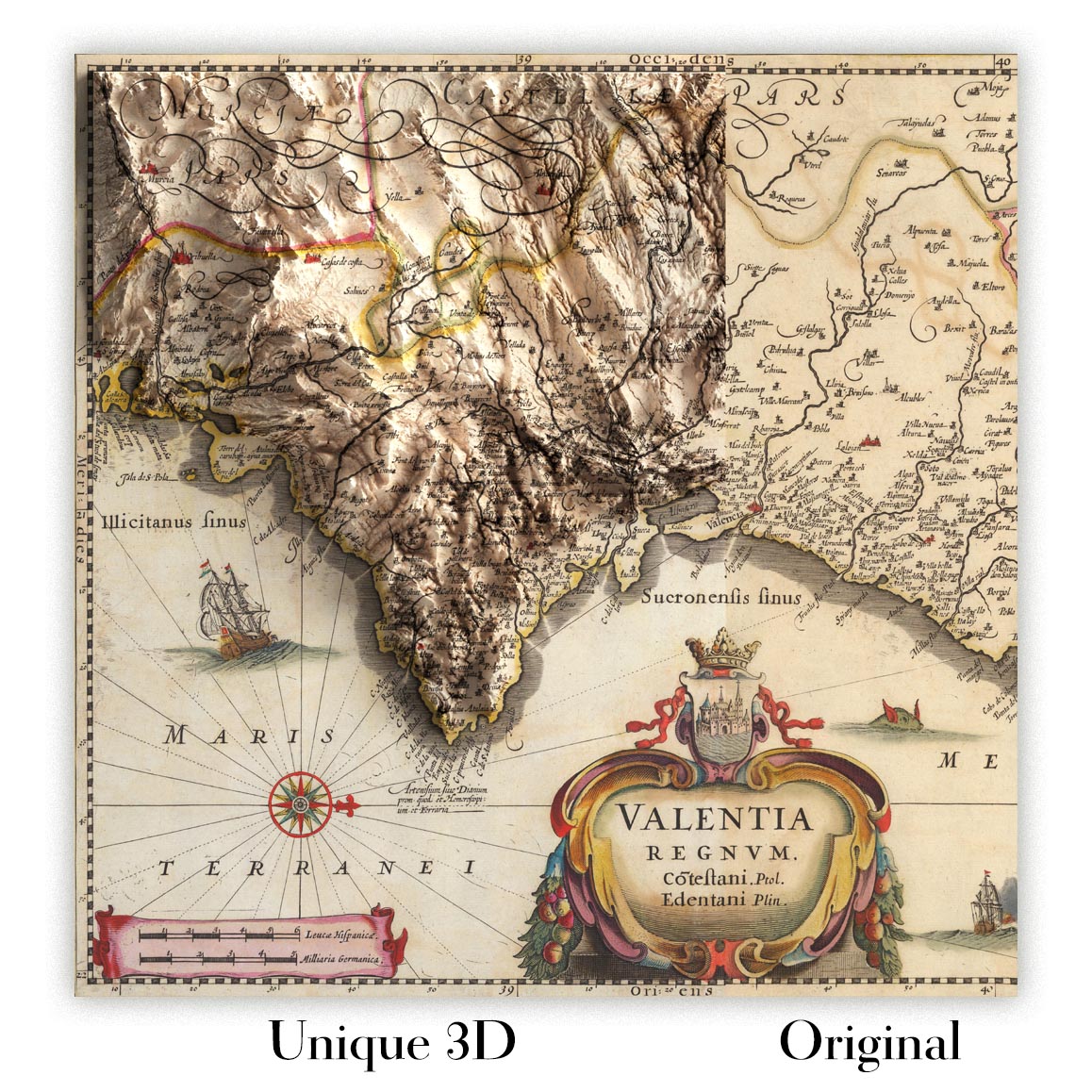
For something truly unique, this map is also available in "Unique 3D", our trademarked process that dramatically transforms the map so that it has a wonderful sense of depth. We combine the original map with detailed topography and elevation data, so that mountains and the terrain really "pop". For more info and examples of 3D maps, check my Unique 3D page.
For most orders, delivery time is about 3 working days. Personalised and customised products take longer, as I have to do the personalisation and send it to you for approval, which usually takes 1 or 2 days.
Please note that very large framed orders usually take longer to make and deliver.
If you need your order to arrive by a certain date, please contact me before you order so that we can find the best way of making sure you get your order in time.
I print and frame maps and artwork in 23 countries around the world. This means your order will be made locally, which cuts down on delivery time and ensures that it won't be damaged during delivery. You'll never pay customs or import duty, and we'll put less CO2 into the air.
All of my maps and art prints are well packaged and sent in a rugged tube if unframed, or surrounded by foam if framed.
I try to send out all orders within 1 or 2 days of receiving your order, though some products (like face masks, mugs and tote bags) can take longer to make.
If you select Express Delivery at checkout your order we will prioritise your order and send it out by 1-day courier (Fedex, DHL, UPS, Parcelforce).
Next Day delivery is also available in some countries (US, UK, Singapore, UAE) but please try to order early in the day so that we can get it sent out on time.
My standard frame is a gallery style black ash hardwood frame. It is simple and quite modern looking. My standard frame is around 20mm (0.8in) wide.
I use super-clear acrylic (perspex/acrylite) for the frame glass. It's lighter and safer than glass - and it looks better, as the reflectivity is lower.
Six standard frame colours are available for free (black, dark brown, dark grey, oak, white and antique gold). Custom framing and mounting/matting is available if you're looking for something else.
Most maps, art and illustrations are also available as a framed canvas. We use matte (not shiny) cotton canvas, stretch it over a sustainably sourced box wood frame, and then 'float' the piece within a wood frame. The end result is quite beautiful, and there's no glazing to get in the way.
All frames are provided "ready to hang", with either a string or brackets on the back. Very large frames will have heavy duty hanging plates and/or a mounting baton. If you have any questions, please get in touch.
See some examples of my framed maps and framed canvas maps.
Alternatively, I can also supply old maps and artwork on canvas, foam board, cotton rag and other materials.
If you want to frame your map or artwork yourself, please read my size guide first.
Alcune delle mie vecchie mappe sono ora disponibili come tele incorniciate. Per favore contattami se desideri ordinare una dimensione che non è disponibile nel mio negozio.
Le vecchie mappe su tela sono un'alternativa interessante alle mappe incorniciate in modo convenzionale. A seconda del tuo gusto personale e dell'arredamento della stanza, le mappe su tela possono "risaltare" un po' di più rispetto a una mappa incorniciata.
My maps are extremely high quality reproductions of original maps.
I source original, rare maps from libraries, auction houses and private collections around the world, restore them at my London workshop, and then use specialist giclée inks and printers to create beautiful maps that look even better than the original.
My maps are printed on acid-free archival matte (not glossy) paper that feels very high quality and almost like card. In technical terms the paper weight/thickness is 10mil/200gsm. It's perfect for framing.
I print with Epson ultrachrome giclée UV fade resistant pigment inks - some of the best inks you can find.
I can also make maps on canvas, cotton rag and other exotic materials.
Learn more about The Unique Maps Co.
Map personalisation
If you're looking for the perfect anniversary or housewarming gift, I can personalise your map to make it truly unique. For example, I can add a short message, or highlight an important location, or add your family's coat of arms.
The options are almost infinite. Please see my map personalisation page for some wonderful examples of what's possible.
To order a personalised map, select "personalise your map" before adding it to your basket.
Get in touch if you're looking for more complex customisations and personalisations.
Map ageing
I have been asked hundreds of times over the years by customers if they could buy a map that looks even older.
Well, now you can, by selecting Aged before you add a map to your basket.
All the product photos you see on this page show the map in its Original form. This is what the map looks like today.
If you select Aged, I will age your map by hand, using a special and unique process developed through years of studying old maps, talking to researchers to understand the chemistry of aging paper, and of course... lots of practice!
If you're unsure, stick to the Original colour of the map. If you want something a bit darker and older looking, go for Aged.
Se non sei soddisfatto del tuo ordine per qualsiasi motivo, contattami per un rimborso senza problemi. Si prega di consultare la nostra politica di reso e rimborso per ulteriori informazioni.
Sono molto sicuro che ti piacerà la tua mappa restaurata o la stampa d'arte. Lo faccio dal 1984. Sono un venditore Etsy a 5 stelle. Ho venduto decine di migliaia di mappe e stampe d'arte e ho oltre 5.000 recensioni reali a 5 stelle.
Utilizzo un processo unico per restaurare mappe e opere d'arte che richiede molto tempo e lavoro. Trovare le mappe e le illustrazioni originali può richiedere mesi. Utilizzo tecnologia all'avanguardia e incredibilmente costosa per scannerizzare e restaurarle. Di conseguenza, garantisco che le mie mappe e stampe d'arte siano superiori alle altre - ecco perché posso offrire un rimborso senza problemi.
Quasi tutte le mie mappe e stampe d'arte sembrano fantastiche a grandi dimensioni (200 cm, 6,5 piedi+) e posso anche incorniciarle e consegnarle a te, tramite un corriere speciale per oggetti di grandi dimensioni. Contattami per discutere delle tue esigenze specifiche.
Or try searching for something!


