


Mappa antica dell'Olanda di Visscher, 1690: Amsterdam, Rotterdam, L'Aia, Utrecht, Leiden
Compra 2, Ricevi 1 Gratuito
Se aggiungi 2 articoli al tuo carrello, puoi aggiungere un terzo prodotto gratuitamente.
Questo vale per tutte le mappe e opere d'arte, comprese le opere personalizzate e su misura. Puoi ordinare 3 dello stesso articolo, o 3 articoli diversi.
Questo equivale a uno sconto del 33%, che sarà il maggiore sconto disponibile nel mio negozio quest'anno.
Ti prego di approfittare dell'offerta e di coprire le tue pareti con bellissime mappe e opere d'arte!
Contattami se hai domande.

-
![]() Handmade locally in the EU
Handmade locally in the EU
-
FREE worldwide delivery in 2-3 days ⓘ
Free delivery in 2-3 days
Your map should be delivered in 2-3 working days with free delivery, worldwide.
Deliveries over the Christmas and New Year period may be slightly delayed, as couriers and postal services catch up with a huge backlog of packages.
We make maps by hand locally in 23 countries, including the EU
![]() . If you're buying a gift for someone in another country, we will make the map locally to them.
. If you're buying a gift for someone in another country, we will make the map locally to them.You will never pay import tax or customs duty.
Express delivery is available at checkout which can reduce the delivery time to 1-2 days.
Please note that personalised maps, and larger framed maps, can take longer to produce and deliver.
If you need your order to arrive by a certain date, contact me and we can discuss your options.
-
FREE gift preview
ⓘ
Digital gift preview
After you complete your order, you can send a beautiful digital preview to the gift recipient. Just provide their email address and we'll do the rest. (Their email address will not be stored or used for any other purpose.)
This is perfect if you're concerned that your order might not arrive in time.
You can also buy a real non-expiring gift card, and email it directly to the recipient, so they can buy their own map or artwork.
-
90 day money back guarantee
ⓘ
90 giorni per restituire e ricevere un rimborso
I prodotti possono essere restituiti entro 90 giorni per un rimborso completo, o cambio con un altro prodotto.
Per articoli personalizzati e su misura, potremmo offrirti un credito in negozio o una carta regalo non scadente, poiché non possiamo rivendere ordini personalizzati.
Se hai domande, contattaci. Per ulteriori informazioni, consulta la nostra politica di restituzione e cambio.

My maps are rare, museum-grade, restored old maps sourced from libraries, auction houses and private collections across the globe.
Framing & free personalisation available
1. Select your size
Click here to order a custom size.
2. Frame & personalise your map
Make your map unique with framing, hand-drawn customisation, vintage ageing, pop art text, unique 3D styling and more.


Gift message & custom finish

If you want to add a gift message, or a finish (jigsaw, aluminium board, etc.) that is not available here, please request it in the "order note" when you check out.
Every order is custom made, so if you need the size adjusted slightly, or printed on an unusual material, just let us know. We've done thousands of custom orders over the years, so there's (almost) nothing we can't manage.
You can also contact us before you order, if you prefer!

- Handmade locally. No import duty or tax
- FREE worldwide delivery
- Love it or your money back (90 days)
- Questions? WhatsApp me any time
Own a piece of history
5,000+ 5 star reviews


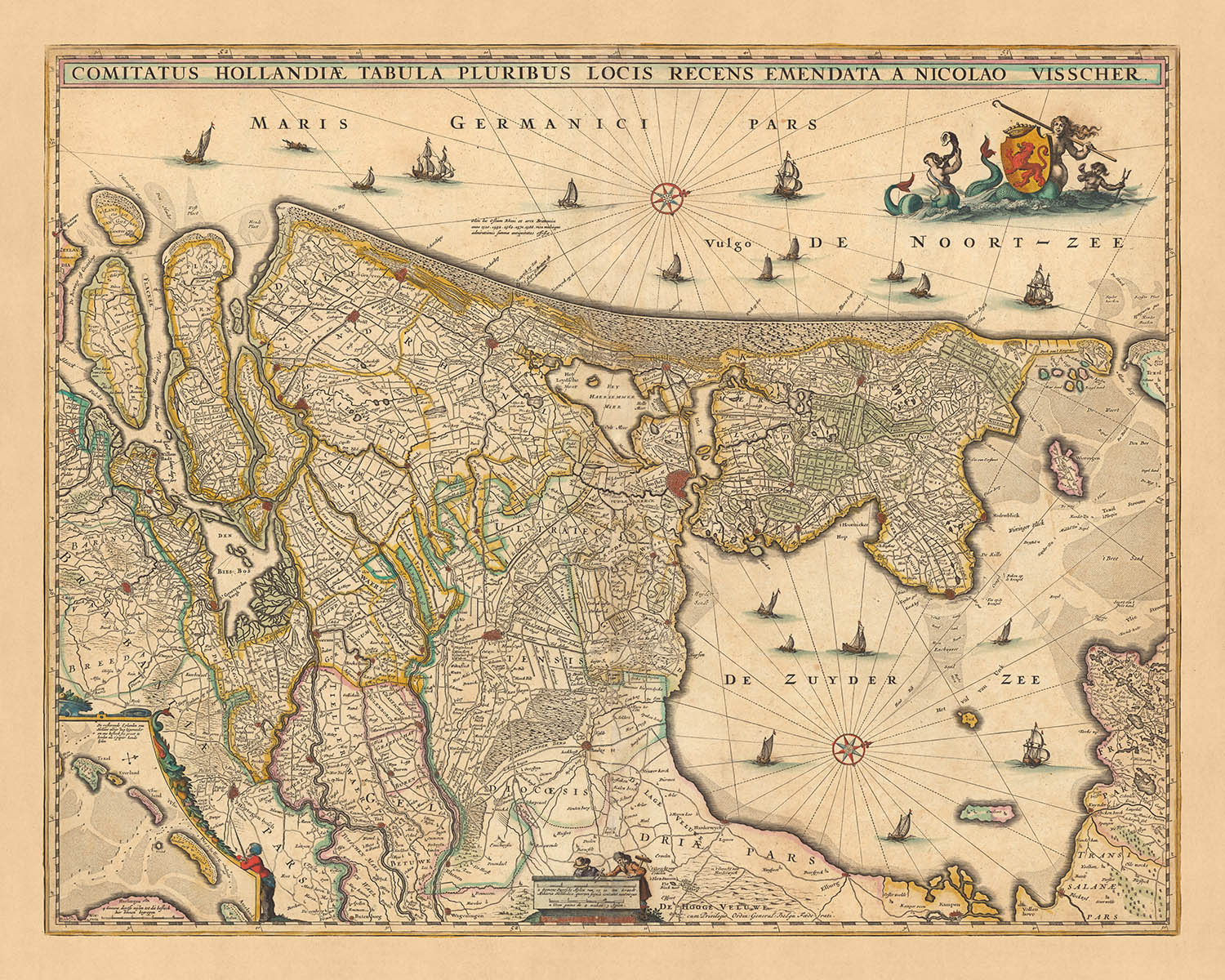
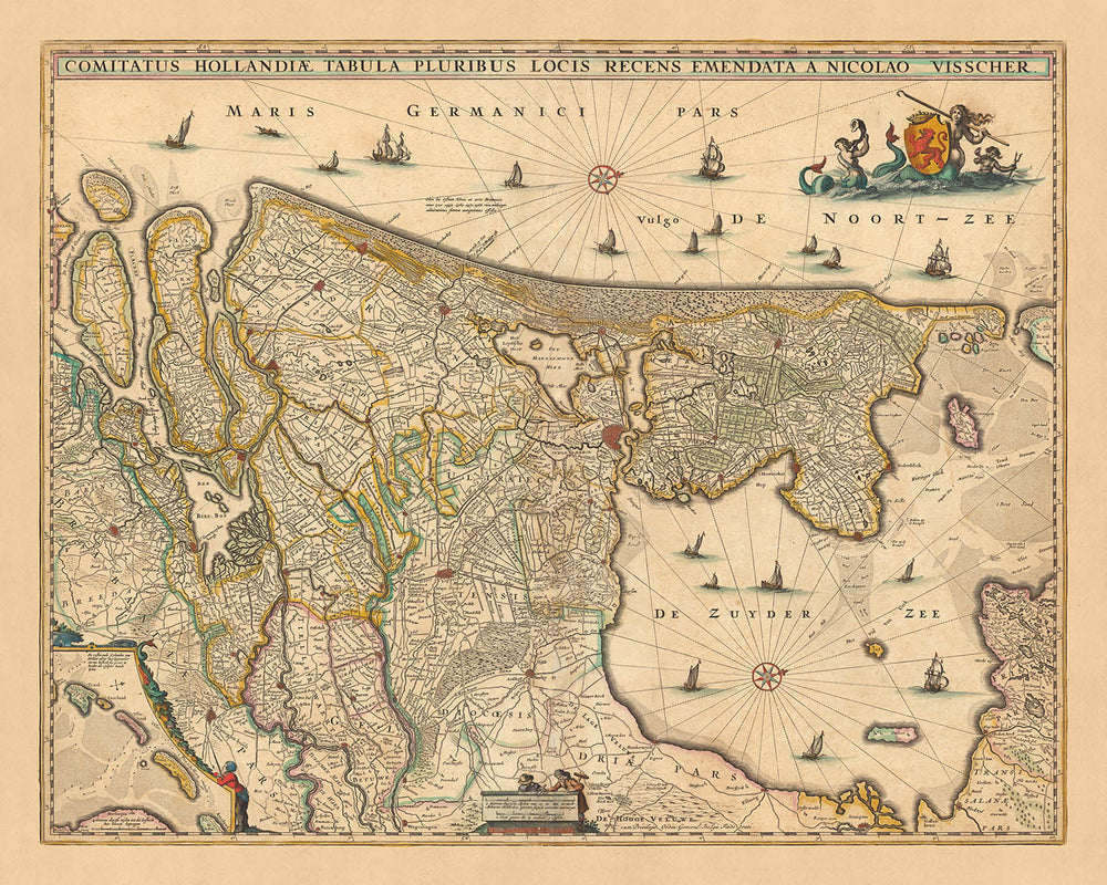
Immergiti nella ricca storia dell'età dell'oro olandese con questa squisita mappa, 'Comitatus Hollandiae tabula', realizzata dal rinomato cartografo Nicolaes Visscher II nel 1690. Tradotto in inglese, il titolo della mappa significa 'Mappa della Contea di Holland', offrendo una vista dettagliata delle varie regioni e divisioni politiche dell'Olanda, un'area significativa nei Paesi Bassi moderni.
Città notevoli presenti in modo prominente su questa mappa includono Amsterdam, Rotterdam, L'Aia, Utrecht e Leiden. Ogni città ha una ricca storia e un significato culturale. Amsterdam, la capitale dei Paesi Bassi, era già un vivace centro di commercio e arte al tempo in cui questa mappa è stata realizzata. Rotterdam, conosciuta per la sua storia marittima, è uno dei più grandi porti marittimi del mondo. L'Aia, la capitale amministrativa, è la sede della famiglia reale olandese e della Corte internazionale di giustizia. Utrecht, una delle città più antiche dei Paesi Bassi, vanta una ricca storia ecclesiastica. Leiden, il luogo di nascita di Rembrandt, è famosa per la sua architettura secolare e la più antica università dei Paesi Bassi.
Oltre a queste città, la mappa fornisce anche una vista dettagliata delle intricate vie d'acqua e delle caratteristiche topografiche della regione. La vasta rete di canali, fiumi e laghi illustra le impressionanti imprese di ingegneria olandese e il loro rapporto storico con la gestione dell'acqua. Queste caratteristiche sono una testimonianza della lunga battaglia dei Paesi Bassi contro il mare e del loro successo nel recupero di terre.
Nicolaes Visscher II, il creatore della mappa, apparteneva alla prestigiosa famiglia Visscher di cartografi, artisti e editori. Era il nipote di Claes Janszoon Visscher, uno dei migliori cartografi dell'età dell'oro olandese. Questa mappa, quindi, non è solo una rappresentazione geografica, ma anche un'opera d'arte, portando l'eredità di una famiglia che ha contribuito notevolmente all'età dell'oro della cartografia olandese. Con il suo significato storico e artistico, questa mappa offre un viaggio unico nel passato, rendendola un'aggiunta perfetta a qualsiasi collezione o un pensiero riflessivo per gli appassionati di storia e mappe.
Alcuni dei luoghi significativi mostrati su questa mappa:
Nella Contea di Holland:
- Amsterdam: Conosciuta come Amstelredamme nei primi tempi, era già un centro di commercio fiorente nel 1690, specialmente nota per la sua borsa valori.
- Rotterdam: Conosciuta per la sua storia marittima, Rotterdam era un porto marittimo significativo durante l'età dell'oro olandese.
- L'Aia (Den Haag): Storicamente conosciuta come 's-Gravenhage, era la capitale amministrativa e sede della famiglia reale olandese.
- Leiden: Il luogo di nascita del famoso pittore Rembrandt, era anche nota per la sua università storica, fondata nel 1575.
- Haarlem: Conosciuta per i suoi campi di tulipani e la scena artistica, era un importante centro per i pittori dell'età dell'oro olandese.
- Delft: Famosa per la sua ceramica blu e come il luogo di nascita del pittore Vermeer.
- Alkmaar: Conosciuta per il suo mercato del formaggio, era un hub commerciale per i prodotti lattiero-caseari.
- Gouda: Un'altra città nota per il suo formaggio, aveva anche significative industrie tessili e di birrificazione.
- Schiedam: Conosciuta per le sue distillerie di jenever (gin olandese) e mulini a vento.
- Vlaardingen: Una importante città di pesca nel XVII secolo, nota soprattutto per l'aringa.
- Hoorn: Un importante porto marittimo e la città fondatrice della Compagnia Olandese delle Indie Orientali.
- Enkhuizen: Un'altra città fondatrice della Compagnia Olandese delle Indie Orientali, nota per la pesca dell'aringa.
- Medemblik: La città più antica della Frisia Occidentale, era una vivace città commerciale.
- Brielle: Conosciuta anche come Den Briel, era una base militare e navale strategica.
- Schoonhoven: Nota per il suo argento, da cui il soprannome Zilverstad (Città d'Argento).
Nella Signoria di Utrecht:
- Utrecht: Una delle città più antiche dei Paesi Bassi, era un centro religioso con una cattedrale significativa.
- Amersfoort: Nota per la sua industria del tabacco e la produzione di birra.
- Zeist: Nota per i suoi castelli e le sue ville.
- Rhenen: Nota per la sua posizione strategica sul fiume Reno.
- Montfoort: Nota per le sue fortificazioni e il suo castello.
Fenomeni Naturali e Confini Notabili:
- Il fiume Reno: Un'importante via d'acqua per il commercio e il trasporto.
- Il fiume Schelda: Un'altra via d'acqua significativa, che porta al Mare del Nord.
- Il fiume IJssel: Nota per la sua bellezza scenica.
- Il Zuiderzee: Una baia poco profonda del Mare del Nord, importante per la pesca e il commercio.
- Il confine con il Sacro Romano Impero: Un importante confine politico e commerciale.
Eventi Storici Notabili (1600-1690):
- La Pace dei Dodici Anni (1609-1621): Una pausa significativa nella Guerra dei Trent'Anni contro la Spagna.
- Il Sinodo di Dort (1618-1619): Un'importante riunione religiosa che portò allo sviluppo della Chiesa Riformata Olandese.
- Anno Disastroso (1672): Quando Francia, Inghilterra, il Vescovato di Münster e l'Arcivescovato di Colonia attaccarono congiuntamente la Repubblica Olandese.
Si prega di controllare attentamente le immagini per assicurarsi che una specifica città o luogo sia mostrato su questa mappa. Puoi anche contattarci e chiedere di controllare la mappa per te.
Questa mappa appare ottima in tutte le dimensioni: 12x16in (30.5x41cm), 16x20in (40.5x51cm), 18x24in (45.5x61cm), 24x30in (61x76cm), 32x40in (81.5x102cm), 40x50in (102x127cm), 48x60in (122x153cm) e 56x70in (142x178cm), ma appare ancora meglio quando stampata grande.
Posso creare bellissime stampe grandi di questa mappa fino a 90in (229cm). Ti prego di contattarmi se stai cercando opzioni di stampa più grandi, personalizzate o diverse.
Il modello nelle immagini dell'annuncio tiene la versione 16x20in (40.5x51cm) di questa mappa.
La quinta immagine dell'annuncio mostra un esempio del mio servizio di personalizzazione della mappa.
Se stai cercando qualcosa di leggermente diverso, dai un'occhiata alla mia collezione delle migliori mappe antiche d'Europa e delle città europee per vedere se qualcosa attira la tua attenzione.
Si prega di contattarmi per verificare se una certa posizione, un punto di riferimento o una caratteristica è mostrata su questa mappa.
Questo sarebbe un meraviglioso regalo per un compleanno, Natale, Festa del Papà, un addio al lavoro, un anniversario o un regalo per la nuova casa per qualcuno delle aree coperte da questa mappa.
Questa mappa è disponibile come stampa giclée su carta opaca archivistica priva di acidi, oppure puoi acquistarla incorniciata. La cornice è una semplice cornice nera che si adatta alla maggior parte degli stili. Ti preghiamo di contattarci se desideri un colore o un materiale di cornice diverso. Le mie cornici sono vetriate con acrilico super chiaro di qualità museale (perspex/acrylite), che è significativamente meno riflettente del vetro, più sicuro e arriverà sempre in perfette condizioni.
This map is also available as a float framed canvas, sometimes known as a shadow gap framed canvas or canvas floater. The map is printed on artist's cotton canvas and then stretched over a handmade box frame. We then "float" the canvas inside a wooden frame, which is available in a range of colours (black, dark brown, oak, antique gold and white). This is a wonderful way to present a map without glazing in front. See some examples of float framed canvas maps and explore the differences between my different finishes.
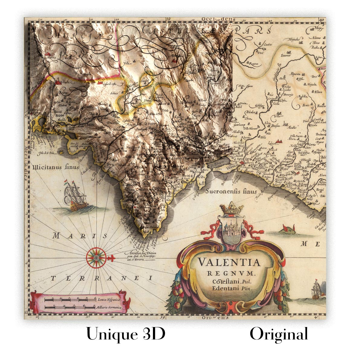
For something truly unique, this map is also available in "Unique 3D", our trademarked process that dramatically transforms the map so that it has a wonderful sense of depth. We combine the original map with detailed topography and elevation data, so that mountains and the terrain really "pop". For more info and examples of 3D maps, check my Unique 3D page.
For most orders, delivery time is about 3 working days. Personalised and customised products take longer, as I have to do the personalisation and send it to you for approval, which usually takes 1 or 2 days.
Please note that very large framed orders usually take longer to make and deliver.
If you need your order to arrive by a certain date, please contact me before you order so that we can find the best way of making sure you get your order in time.
I print and frame maps and artwork in 23 countries around the world. This means your order will be made locally, which cuts down on delivery time and ensures that it won't be damaged during delivery. You'll never pay customs or import duty, and we'll put less CO2 into the air.
All of my maps and art prints are well packaged and sent in a rugged tube if unframed, or surrounded by foam if framed.
I try to send out all orders within 1 or 2 days of receiving your order, though some products (like face masks, mugs and tote bags) can take longer to make.
If you select Express Delivery at checkout your order we will prioritise your order and send it out by 1-day courier (Fedex, DHL, UPS, Parcelforce).
Next Day delivery is also available in some countries (US, UK, Singapore, UAE) but please try to order early in the day so that we can get it sent out on time.
My standard frame is a gallery style black ash hardwood frame. It is simple and quite modern looking. My standard frame is around 20mm (0.8in) wide.
I use super-clear acrylic (perspex/acrylite) for the frame glass. It's lighter and safer than glass - and it looks better, as the reflectivity is lower.
Six standard frame colours are available for free (black, dark brown, dark grey, oak, white and antique gold). Custom framing and mounting/matting is available if you're looking for something else.
Most maps, art and illustrations are also available as a framed canvas. We use matte (not shiny) cotton canvas, stretch it over a sustainably sourced box wood frame, and then 'float' the piece within a wood frame. The end result is quite beautiful, and there's no glazing to get in the way.
All frames are provided "ready to hang", with either a string or brackets on the back. Very large frames will have heavy duty hanging plates and/or a mounting baton. If you have any questions, please get in touch.
See some examples of my framed maps and framed canvas maps.
Alternatively, I can also supply old maps and artwork on canvas, foam board, cotton rag and other materials.
If you want to frame your map or artwork yourself, please read my size guide first.
Alcune delle mie vecchie mappe sono ora disponibili come tele incorniciate. Per favore contattami se desideri ordinare una dimensione che non è disponibile nel mio negozio.
Le vecchie mappe su tela sono un'alternativa interessante alle mappe incorniciate in modo convenzionale. A seconda del tuo gusto personale e dell'arredamento della stanza, le mappe su tela possono "risaltare" un po' di più rispetto a una mappa incorniciata.
My maps are extremely high quality reproductions of original maps.
I source original, rare maps from libraries, auction houses and private collections around the world, restore them at my London workshop, and then use specialist giclée inks and printers to create beautiful maps that look even better than the original.
My maps are printed on acid-free archival matte (not glossy) paper that feels very high quality and almost like card. In technical terms the paper weight/thickness is 10mil/200gsm. It's perfect for framing.
I print with Epson ultrachrome giclée UV fade resistant pigment inks - some of the best inks you can find.
I can also make maps on canvas, cotton rag and other exotic materials.
Learn more about The Unique Maps Co.
Map personalisation
If you're looking for the perfect anniversary or housewarming gift, I can personalise your map to make it truly unique. For example, I can add a short message, or highlight an important location, or add your family's coat of arms.
The options are almost infinite. Please see my map personalisation page for some wonderful examples of what's possible.
To order a personalised map, select "personalise your map" before adding it to your basket.
Get in touch if you're looking for more complex customisations and personalisations.
Map ageing
I have been asked hundreds of times over the years by customers if they could buy a map that looks even older.
Well, now you can, by selecting Aged before you add a map to your basket.
All the product photos you see on this page show the map in its Original form. This is what the map looks like today.
If you select Aged, I will age your map by hand, using a special and unique process developed through years of studying old maps, talking to researchers to understand the chemistry of aging paper, and of course... lots of practice!
If you're unsure, stick to the Original colour of the map. If you want something a bit darker and older looking, go for Aged.
Se non sei soddisfatto del tuo ordine per qualsiasi motivo, contattami per un rimborso senza problemi. Si prega di consultare la nostra politica di reso e rimborso per ulteriori informazioni.
Sono molto sicuro che ti piacerà la tua mappa restaurata o la stampa d'arte. Lo faccio dal 1984. Sono un venditore Etsy a 5 stelle. Ho venduto decine di migliaia di mappe e stampe d'arte e ho oltre 5.000 recensioni reali a 5 stelle.
Utilizzo un processo unico per restaurare mappe e opere d'arte che richiede molto tempo e lavoro. Trovare le mappe e le illustrazioni originali può richiedere mesi. Utilizzo tecnologia all'avanguardia e incredibilmente costosa per scannerizzare e restaurarle. Di conseguenza, garantisco che le mie mappe e stampe d'arte siano superiori alle altre - ecco perché posso offrire un rimborso senza problemi.
Quasi tutte le mie mappe e stampe d'arte sembrano fantastiche a grandi dimensioni (200 cm, 6,5 piedi+) e posso anche incorniciarle e consegnarle a te, tramite un corriere speciale per oggetti di grandi dimensioni. Contattami per discutere delle tue esigenze specifiche.
Or try searching for something!


