


Mappa molto grande e antica di Chicago di Palmatary, 1857: Le Sabbie, Ferrovia, Richmond House, Fiume, Fabbrica di mietitrebbie McCormick

-
![]() Handmade locally in the EU
Handmade locally in the EU
-
FREE Christmas delivery in 3-4 days ⓘ
Free Christmas delivery in 3-4 days
Your map should be delivered in 3-4 working days with free delivery, worldwide.
We make maps by hand locally in 23 countries, including the EU
![]() . If you're buying a gift for someone in another country, we will make the map locally to them.
. If you're buying a gift for someone in another country, we will make the map locally to them.You will never pay import tax or customs duty.
Check the Christmas delivery guide for order deadlines. Delivery times are starting to slow down, and will continue to slow down towards Christmas.
Express delivery is available at checkout which can reduce the delivery time to 1-2 days.
Please note that personalised maps, and larger framed maps, can take longer to produce and deliver.
If you need your order to arrive by a certain date, contact me and we can discuss your options.
-
90 day money back guarantee
ⓘ
90 giorni per restituire e ricevere un rimborso
I prodotti possono essere restituiti entro 90 giorni per un rimborso completo, o cambio con un altro prodotto.
Per articoli personalizzati e su misura, potremmo offrirti un credito in negozio o una carta regalo non scadente, poiché non possiamo rivendere ordini personalizzati.
Se hai domande, contattaci. Per ulteriori informazioni, consulta la nostra politica di restituzione e cambio.

My maps are rare, museum-grade, restored old maps sourced from libraries, auction houses and private collections across the globe.
Framing & free personalisation available
1. Select your size
2. Frame & personalise your map
There is limited framing & personalisation capacity available. Order by 10am tomorrow for Christmas delivery.


Gift message & custom finish

If you want to add a gift message, or a finish (jigsaw, aluminium board, etc.) that is not available here, please request it in the "order note" when you check out.
Every order is custom made, so if you need the size adjusted slightly, or printed on an unusual material, just let us know. We've done thousands of custom orders over the years, so there's (almost) nothing we can't manage.
You can also contact us before you order, if you prefer!

- Handmade locally. No import duty or tax
- FREE Delivery by Christmas
- Love it or your money back (90 days)
- Questions? WhatsApp me any time
Own a piece of history
5,000+ 5 star reviews


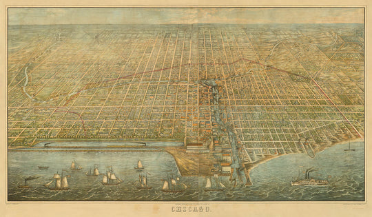
Entra nel cuore pulsante dell'America di metà Ottocento con "Chicago," la vista a volo d'uccello originale del 1857 di James Palmatary. Questa straordinaria mappa pittorica cattura Chicago in un momento cruciale, solo un anno dopo il completamento della Illinois Central Railroad—un catalizzatore per la crescita esplosiva della città. L'arte meticolosa di Palmatary offre un panorama ampio, invitando gli spettatori a esplorare le ambizioni architettoniche e il dinamismo urbano che hanno definito Chicago alla vigilia della sua trasformazione in una metropoli globale.
La Chicago di Palmatary è una città viva di commercio, innovazione e fermento culturale. La mappa illustra vividamente quartieri significativi, in particolare "The Sands," un'area nota vicino all'attuale Streeterville. Un tempo infame per la sua concentrazione di bordelli, case da gioco e saloon, The Sands sarebbe poi diventata un rifugio per i cittadini di Chicago durante il Grande Incendio del 1871. Questa inclusione evocativa offre uno sguardo raro nel tessuto sociale e nelle storie nascoste della città, rendendo la mappa non solo un registro geografico, ma una finestra sulle esperienze vissute dei suoi residenti del XIX secolo.
I punti di riferimento saltano dalla litografia con notevole chiarezza e risonanza storica. La Richmond House, l'Ospedale dei Marine degli Stati Uniti, la Fabbrica di Raccoglitori McCormick e la Birreria Lill & Diversy (la birreria più antica di Chicago) sono tutte etichettate con cura, ognuna rappresentando un capitolo nella storia della potenza industriale e dell'orgoglio civico della città. I Chicago Water Works e le vaste case di grano e merci sottolineano ulteriormente l'emergere della città come un hub vitale di commercio e innovazione, mentre il vivace lungofiume e i porti affollati parlano del suo ruolo come porta verso l'interno americano.
L'arte della mappa è pari alla sua importanza cartografica. La prospettiva a volo d'uccello di Palmatary, resa con meticoloso dettaglio, offre un senso immersivo del luogo—uno che mette in evidenza la griglia di strade della città, il tortuoso fiume Chicago e la vasta distesa del Lago Michigan. Le navi solcano le acque, e i nuovi binari ferroviari completati si snodano attraverso il paesaggio urbano, testimoniando il ruolo di Chicago come crocevia di commercio e migrazione. Ogni edificio, isolato e boulevard è disegnato con un occhio sia per l'accuratezza che per il dramma, invitando collezionisti e storici a tracciare la rapida ascesa della città.
James Palmatary stesso rimane una figura enigmatica, attivo come creatore di vedute tra il 1853 e il 1858 e responsabile di solo circa 20 panorami cittadini noti. Il suo lavoro, che abbraccia città del Midwest e dell'Est, è apprezzato per la sua scala, dettaglio e intuizione storica. Questa vista del 1857 di Chicago è una delle sue opere maestre—un artefatto estremamente raro che sopravvive in solo pochi esemplari in tutto il mondo. Per i cultori della storia urbana e della fine cartografia, "Chicago" di Palmatary non è semplicemente una mappa, ma un portale verso un mondo svanito, ricco di storie e significato.
Strade e vie su questa mappa
- Adams St.
- Canal St.
- Chicago Ave.
- Clark St.
- Clinton St.
- Dearborn St.
- Des Plaines St.
- Franklin St.
- Fulton St.
- Harrison St.
- Jackson St.
- Jefferson St.
- Kinzie St.
- Lake St.
- LaSalle St.
- Madison St.
- Market St.
- Michigan Ave.
- Monroe St.
- North Water St.
- Randolph St.
- Rush St.
- South Water St.
- State St.
- Van Buren St.
- Wabash Ave.
- Washington St.
- Water St.
- Wells St.
- West Randolph St.
Caratteristiche e luoghi notevoli
- Richmond House
- Ospedale dei Marine U.S.
- Grain and Freight Houses
- Fabbrica di mietitrebbie McCormick
- Brewery Lill & Diversy (la birreria più antica di Chicago)
- Chicago Water Works
- "The Sands" (vicino all'attuale Streeterville)
- Lake Michigan
- Fiume Chicago
- Ferrovia Centrale dell'Illinois
- Navi e barche raffigurate sul Lago Michigan e sul Fiume Chicago
Contesto storico e di design
- Titolo originale: Chicago, creato nel 1857 da James Palmatary
- Pubblicato da Charles Sonne; litografato da Christian Inger o Herline & Hensel a Philadelphia
- Seconda vista a volo d'uccello in grande formato di Chicago, dopo la vista di George Robertson del 1853
- Creato solo un anno dopo il completamento della Ferrovia Centrale dell'Illinois, segnando un periodo di rapida crescita urbana
- Prospettiva a volo d'uccello dettagliata, tipica delle mappe pittoriche della metà del XIX secolo
- Mostra la città prima del Grande Incendio di Chicago del 1871, offrendo uno sguardo raro nella Chicago pre-incendio
- Solo circa cinque esemplari noti sono sopravvissuti, con tre in collezioni istituzionali (Chicago Historical Society, Library of Congress, Newberry Library)
- James Palmatary è stato attivo come creatore di vedute dal 1853 al 1858, producendo circa 20 vedute di città in diversi stati
- Mettere in evidenza lo sviluppo urbano di Chicago, le infrastrutture di trasporto, la crescita industriale e la storia sociale
Si prega di controllare attentamente le immagini per assicurarsi che una specifica città o luogo sia mostrato su questa mappa. Puoi anche contattarci e chiedere di controllare la mappa per te.
Questa mappa appare fantastica in ogni formato, ma consiglio sempre di optare per una dimensione più grande se hai spazio. In questo modo puoi facilmente distinguere tutti i dettagli.
Questa mappa appare sorprendente in dimensioni fino a 100in (250cm). Se stai cercando una mappa più grande, ti prego di contattarci.
Si prega di notare: le etichette su questa mappa sono difficili da leggere se ordini una mappa di 36in (90cm) o più piccola. La mappa è comunque molto attraente, ma se desideri leggere facilmente la mappa, ti preghiamo di acquistare una dimensione più grande.
Questa mappa è più larga della maggior parte delle mappe, il che la renderebbe un pezzo d'arredo perfetto sopra un camino, un divano o una scrivania.
La quinta immagine dell'elenco mostra un esempio del mio servizio di personalizzazione della mappa.
Se stai cercando qualcosa di leggermente diverso, dai un'occhiata alla mia collezione delle migliori mappe antiche per vedere se qualcosa attira la tua attenzione.
Si prega di contattarmi per verificare se una certa posizione, monumento o caratteristica è mostrato su questa mappa.
Questo sarebbe un meraviglioso regalo per un compleanno, Natale, Festa del Papà, partenza dal lavoro, anniversario o inaugurazione della casa per qualcuno delle aree coperte da questa mappa.
Questa mappa è disponibile come stampa giclée su carta opaca archivistica priva di acidi, oppure puoi acquistarla incorniciata. La cornice è una semplice e bella cornice nera che si adatta alla maggior parte degli stili. Ti prego di contattarmi se desideri un colore o un materiale di cornice diverso. Le mie cornici sono dotate di un acrilico super chiaro di grado museale (perspex/acrylite), che è significativamente meno riflettente del vetro, più sicuro e arriverà sempre in condizioni perfette.
This map is also available as a float framed canvas, sometimes known as a shadow gap framed canvas or canvas floater. The map is printed on artist's cotton canvas and then stretched over a handmade box frame. We then "float" the canvas inside a wooden frame, which is available in a range of colours (black, dark brown, oak, antique gold and white). This is a wonderful way to present a map without glazing in front. See some examples of float framed canvas maps and explore the differences between my different finishes.
For something truly unique, this map is also available in "Unique 3D", our trademarked process that dramatically transforms the map so that it has a wonderful sense of depth. We combine the original map with detailed topography and elevation data, so that mountains and the terrain really "pop". For more info and examples of 3D maps, check my Unique 3D page.
For most orders, delivery time is about 3 working days. Personalised and customised products take longer, as I have to do the personalisation and send it to you for approval, which usually takes 1 or 2 days.
Please note that very large framed orders usually take longer to make and deliver.
If you need your order to arrive by a certain date, please contact me before you order so that we can find the best way of making sure you get your order in time.
I print and frame maps and artwork in 23 countries around the world. This means your order will be made locally, which cuts down on delivery time and ensures that it won't be damaged during delivery. You'll never pay customs or import duty, and we'll put less CO2 into the air.
All of my maps and art prints are well packaged and sent in a rugged tube if unframed, or surrounded by foam if framed.
I try to send out all orders within 1 or 2 days of receiving your order, though some products (like face masks, mugs and tote bags) can take longer to make.
If you select Express Delivery at checkout your order we will prioritise your order and send it out by 1-day courier (Fedex, DHL, UPS, Parcelforce).
Next Day delivery is also available in some countries (US, UK, Singapore, UAE) but please try to order early in the day so that we can get it sent out on time.
My standard frame is a gallery style black ash hardwood frame. It is simple and quite modern looking. My standard frame is around 20mm (0.8in) wide.
I use super-clear acrylic (perspex/acrylite) for the frame glass. It's lighter and safer than glass - and it looks better, as the reflectivity is lower.
Six standard frame colours are available for free (black, dark brown, dark grey, oak, white and antique gold). Custom framing and mounting/matting is available if you're looking for something else.
Most maps, art and illustrations are also available as a framed canvas. We use matte (not shiny) cotton canvas, stretch it over a sustainably sourced box wood frame, and then 'float' the piece within a wood frame. The end result is quite beautiful, and there's no glazing to get in the way.
All frames are provided "ready to hang", with either a string or brackets on the back. Very large frames will have heavy duty hanging plates and/or a mounting baton. If you have any questions, please get in touch.
See some examples of my framed maps and framed canvas maps.
Alternatively, I can also supply old maps and artwork on canvas, foam board, cotton rag and other materials.
If you want to frame your map or artwork yourself, please read my size guide first.
Alcune delle mie vecchie mappe sono ora disponibili come tele incorniciate. Per favore contattami se desideri ordinare una dimensione che non è disponibile nel mio negozio.
Le vecchie mappe su tela sono un'alternativa interessante alle mappe incorniciate in modo convenzionale. A seconda del tuo gusto personale e dell'arredamento della stanza, le mappe su tela possono "risaltare" un po' di più rispetto a una mappa incorniciata.
My maps are extremely high quality reproductions of original maps.
I source original, rare maps from libraries, auction houses and private collections around the world, restore them at my London workshop, and then use specialist giclée inks and printers to create beautiful maps that look even better than the original.
My maps are printed on acid-free archival matte (not glossy) paper that feels very high quality and almost like card. In technical terms the paper weight/thickness is 10mil/200gsm. It's perfect for framing.
I print with Epson ultrachrome giclée UV fade resistant pigment inks - some of the best inks you can find.
I can also make maps on canvas, cotton rag and other exotic materials.
Learn more about The Unique Maps Co.
Map personalisation
If you're looking for the perfect anniversary or housewarming gift, I can personalise your map to make it truly unique. For example, I can add a short message, or highlight an important location, or add your family's coat of arms.
The options are almost infinite. Please see my map personalisation page for some wonderful examples of what's possible.
To order a personalised map, select "personalise your map" before adding it to your basket.
Get in touch if you're looking for more complex customisations and personalisations.
Map ageing
I have been asked hundreds of times over the years by customers if they could buy a map that looks even older.
Well, now you can, by selecting Aged before you add a map to your basket.
All the product photos you see on this page show the map in its Original form. This is what the map looks like today.
If you select Aged, I will age your map by hand, using a special and unique process developed through years of studying old maps, talking to researchers to understand the chemistry of aging paper, and of course... lots of practice!
If you're unsure, stick to the Original colour of the map. If you want something a bit darker and older looking, go for Aged.
Se non sei soddisfatto del tuo ordine per qualsiasi motivo, contattami per un rimborso senza problemi. Si prega di consultare la nostra politica di reso e rimborso per ulteriori informazioni.
Sono molto sicuro che ti piacerà la tua mappa restaurata o la stampa d'arte. Lo faccio dal 1984. Sono un venditore Etsy a 5 stelle. Ho venduto decine di migliaia di mappe e stampe d'arte e ho oltre 5.000 recensioni reali a 5 stelle.
Utilizzo un processo unico per restaurare mappe e opere d'arte che richiede molto tempo e lavoro. Trovare le mappe e le illustrazioni originali può richiedere mesi. Utilizzo tecnologia all'avanguardia e incredibilmente costosa per scannerizzare e restaurarle. Di conseguenza, garantisco che le mie mappe e stampe d'arte siano superiori alle altre - ecco perché posso offrire un rimborso senza problemi.
Quasi tutte le mie mappe e stampe d'arte sembrano fantastiche a grandi dimensioni (200 cm, 6,5 piedi+) e posso anche incorniciarle e consegnarle a te, tramite un corriere speciale per oggetti di grandi dimensioni. Contattami per discutere delle tue esigenze specifiche.
Or try searching for something!


