


Mappa antica del Nuovo Galles del Sud di Stanford, 1904: Sydney, Newcastle, Wollongong, Ferrovie

-
![]() Handmade locally in the EU
Handmade locally in the EU
-
FREE worldwide delivery in 2-3 days ⓘ
Free delivery in 2-3 days
Your map should be delivered in 2-3 working days with free delivery, worldwide.
We make maps by hand locally in 23 countries, including the EU
![]() . If you're buying a gift for someone in another country, we will make the map locally to them.
. If you're buying a gift for someone in another country, we will make the map locally to them.You will never pay import tax or customs duty.
Express delivery is available at checkout which can reduce the delivery time to 1-2 days.
Please note that personalised maps, and larger framed maps, can take longer to produce and deliver.
If you need your order to arrive by a certain date, contact me and we can discuss your options.
-
90 day money back guarantee
ⓘ
90 giorni per restituire e ottenere un rimborso
I prodotti possono essere restituiti entro 90 giorni per un rimborso completo, o scambio con un altro prodotto.
Per articoli personalizzati o su misura, potremmo offrirti un credito in negozio o una carta regalo non scadente, poiché non possiamo rivendere ordini personalizzati.
Se hai domande, contattaci. Per ulteriori informazioni, consulta la nostra politica di restituzione e scambio.

My maps are rare, museum-grade, restored old maps sourced from libraries, auction houses and private collections across the globe.
Framing & free personalisation available
1. Select your size
2. Frame & personalise your map
Make your map unique with framing, hand-drawn customisation, vintage ageing, pop art text, unique 3D styling and moreGift message & custom finish

If you want to add a gift message, or a finish (jigsaw, aluminium board, etc.) that is not available here, please request it in the "order note" when you check out.
Every order is custom made, so if you need the size adjusted slightly, or printed on an unusual material, just let us know. We've done thousands of custom orders over the years, so there's (almost) nothing we can't manage.
You can also contact us before you order, if you prefer!

- Handmade locally. No import duty or tax
- FREE Delivery. Arrives in 2-3 days
- Love it or your money back
- Questions? WhatsApp me any time
Own a piece of history
5,000+ 5 star reviews


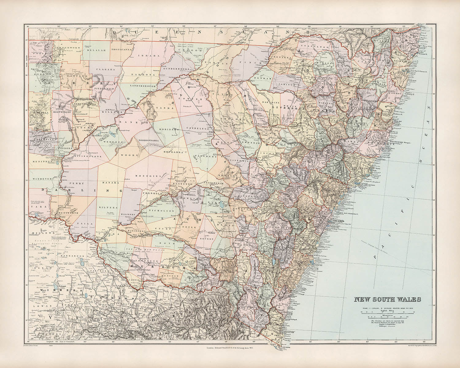
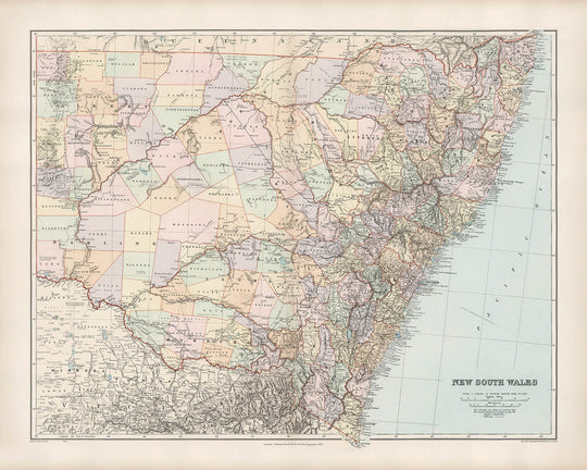
La mappa intitolata "Nuovo Galles del Sud" di Edward Stanford, realizzata nel 1904, è una testimonianza dell'arte della cartografia all'inizio del XX secolo. Stanford, una figura di spicco nel mondo della cartografia, acquisì le lastre dell'Atlante di Londra di John Arrowsmith, permettendogli di costruire su un'eredità di documentazione geografica dettagliata. Questa mappa fa parte di un atlante pubblicato per la prima volta nel 1887, succedendo al lavoro di Arrowsmith del 1858. Il design intricato e la litografia a colori vivaci la rendono un pezzo eccezionale, riflettendo sia i paesaggi politici che fisici con precisione e arte.
La mappa di Stanford del Nuovo Galles del Sud è una lezione magistrale nel design cartografico, utilizzando hachures e altezze puntuali per trasmettere il variegato rilievo della regione. Le contee sono rappresentate a colori, offrendo un ritratto vivido del paesaggio. Strade, ferrovie e linee telegrafiche sono meticolosamente segnate, mostrando l'infrastruttura in espansione dell'epoca. Questa mappa non solo funge da guida geografica, ma anche da documento storico, catturando l'essenza di una regione in transizione.
La mappa evidenzia le città e i paesi vivaci del Nuovo Galles del Sud, tra cui Sydney, Newcastle e Wollongong, tra gli altri. Ogni insediamento è accuratamente tracciato, fornendo un'idea della distribuzione della popolazione e dello sviluppo urbano dei primi anni 1900. Le caratteristiche costiere lungo il bordo orientale e la rappresentazione di fiumi e corpi idrici aggiungono al fascino della mappa, offrendo una vista completa della bellezza naturale della regione.
Oltre ai centri urbani, la mappa mostra il terreno aspro del Nuovo Galles del Sud, con catene montuose rappresentate in dettagli straordinari. L'uso di tecniche di rilievo dà vita al paesaggio, illustrando le sfide e le opportunità presentate dall'ambiente naturale. Questa attenzione ai dettagli sottolinea l'impegno di Stanford per l'accuratezza e la sua passione per catturare l'essenza della terra.
Storicamente, questa mappa è significativa poiché riflette i cambiamenti e gli sviluppi del suo tempo. Come parte di una serie di atlanti di prim'ordine, offre una finestra sul passato, fornendo un contesto prezioso per storici e appassionati. La fusione di arte e precisione nel lavoro di Stanford assicura che questa mappa rimanga un pezzo prezioso della storia cartografica, invitando all'esplorazione e all'ammirazione di tutti coloro che la incontrano.
Città e paesi su questa mappa
- Sydney
- Newcastle
- Wollongong
- Maitland
- Goulburn
- Bathurst
- Dubbo
- Armidale
- Tamworth
- Wagga Wagga
- Lismore
- Coffs Harbour
- Port Macquarie
- Orange
- Broken Hill
- Albury
- Nowra
- Queanbeyan
- Griffith
- Taree
Caratteristiche e luoghi notevoli
- Hachures e altezze puntuali che indicano il rilievo
- Ferrovie e linee telegrafiche
- Strade che collegano gli insediamenti
- Confini delle contee chiaramente segnati
- Caratteristiche costiere lungo il bordo orientale
- Fiumi e corpi idrici
- Catene montuose rappresentate con rilievo
Contesto storico e di design
- Creato da Edward Stanford nel 1904
- Parte di un atlante pubblicato per la prima volta nel 1887, succedendo all'Atlante di Londra di John Arrowsmith del 1858
- Litografia a colori con dettagli politici e fisici
- Riflette l'infrastruttura e il paesaggio del Nuovo Galles del Sud all'inizio del XX secolo
- Considerato l'atlante di prim'ordine del suo tempo, con aggiornamenti che riflettono i cambiamenti nel corso di diversi decenni
Si prega di controllare attentamente le immagini per assicurarsi che una specifica città o luogo sia mostrato su questa mappa. Puoi anche contattarci e chiedere di controllare la mappa per te.
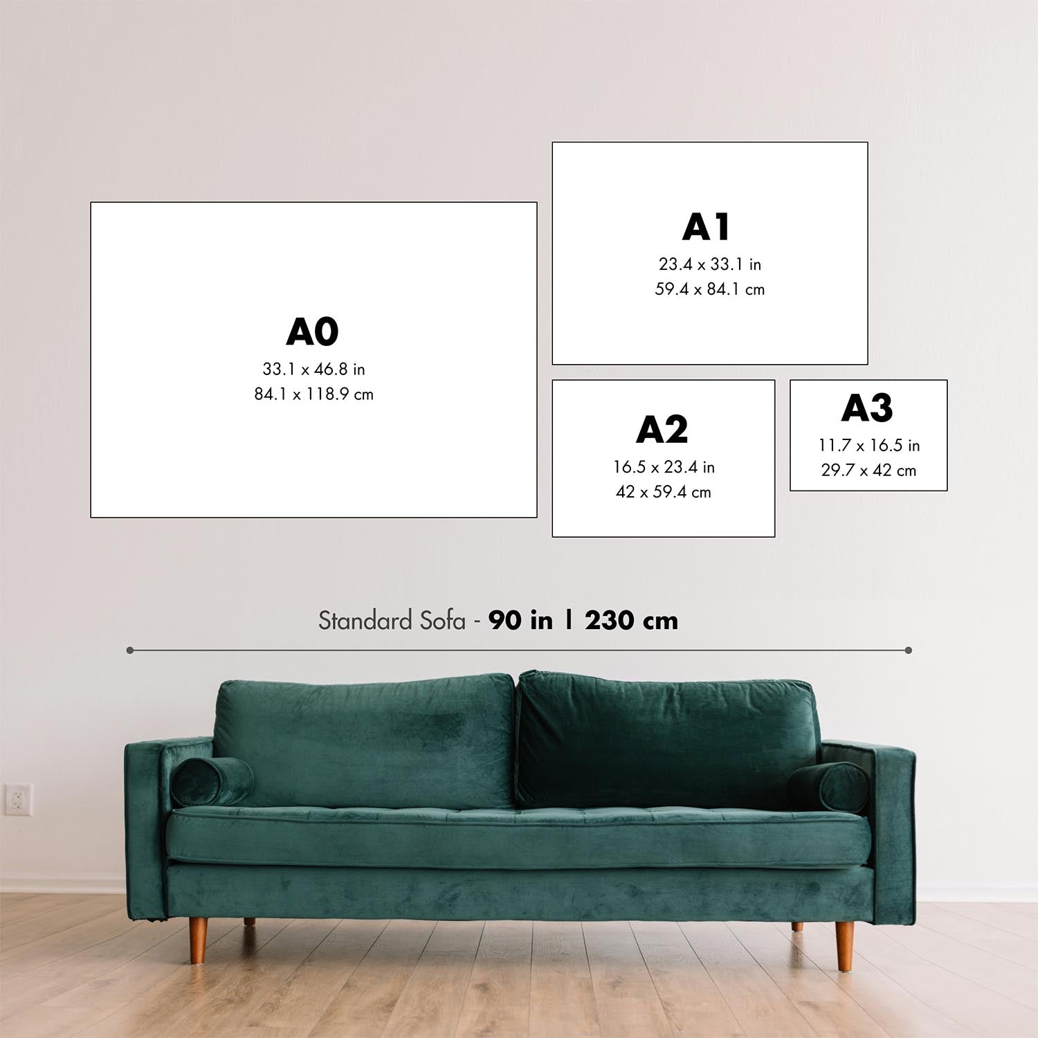
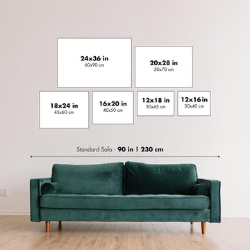
Questa mappa appare fantastica a qualsiasi dimensione, ma consiglio sempre di optare per una dimensione più grande se hai spazio. In questo modo puoi facilmente distinguere tutti i dettagli.
Questa mappa appare incredibile a dimensioni fino a 70 pollici (180 cm). Se stai cercando una mappa più grande, per favore contattaci.
Si prega di notare: le etichette su questa mappa sono difficili da leggere se ordini una mappa che è 16 pollici (40 cm) o più piccola. La mappa è comunque molto attraente, ma se desideri leggere facilmente la mappa, ti preghiamo di acquistare una dimensione più grande.
Il modello nelle immagini dell'annuncio tiene la versione 16x20 pollici (40x50 cm) di questa mappa.
La quinta immagine dell'annuncio mostra un esempio del mio servizio di personalizzazione della mappa.
Se stai cercando qualcosa di leggermente diverso, dai un'occhiata alla mia collezione dei migliori mappe antiche per vedere se qualcosa attira la tua attenzione.
Per favore contattami per controllare se una certa posizione, punto di riferimento o caratteristica è mostrata su questa mappa.
Questo sarebbe un meraviglioso regalo di compleanno, Natale, Festa del Papà, partenza dal lavoro, anniversario o per una nuova casa per qualcuno delle aree coperte da questa mappa.
Questa mappa è disponibile come stampa giclée su carta opaca archivistica senza acidi, oppure puoi acquistarla incorniciata. La cornice è una semplice cornice nera che si adatta alla maggior parte degli stili. Per favore contattaci se desideri un colore o un materiale della cornice diverso. Le mie cornici sono dotate di un acrilico (perspex/acrylite) di grado museale super chiaro, che è significativamente meno riflettente del vetro, più sicuro e arriverà sempre in perfette condizioni.
This map is also available as a float framed canvas, sometimes known as a shadow gap framed canvas or canvas floater. The map is printed on artist's cotton canvas and then stretched over a handmade box frame. We then "float" the canvas inside a wooden frame, which is available in a range of colours (black, dark brown, oak, antique gold and white). This is a wonderful way to present a map without glazing in front. See some examples of float framed canvas maps and explore the differences between my different finishes.
For something truly unique, this map is also available in "Unique 3D", our trademarked process that dramatically transforms the map so that it has a wonderful sense of depth. We combine the original map with detailed topography and elevation data, so that mountains and the terrain really "pop". For more info and examples of 3D maps, check my Unique 3D page.
For most orders, delivery time is about 3 working days. Personalised and customised products take longer, as I have to do the personalisation and send it to you for approval, which usually takes 1 or 2 days.
Please note that very large framed orders usually take longer to make and deliver.
If you need your order to arrive by a certain date, please contact me before you order so that we can find the best way of making sure you get your order in time.
I print and frame maps and artwork in 23 countries around the world. This means your order will be made locally, which cuts down on delivery time and ensures that it won't be damaged during delivery. You'll never pay customs or import duty, and we'll put less CO2 into the air.
All of my maps and art prints are well packaged and sent in a rugged tube if unframed, or surrounded by foam if framed.
I try to send out all orders within 1 or 2 days of receiving your order, though some products (like face masks, mugs and tote bags) can take longer to make.
If you select Express Delivery at checkout your order we will prioritise your order and send it out by 1-day courier (Fedex, DHL, UPS, Parcelforce).
Next Day delivery is also available in some countries (US, UK, Singapore, UAE) but please try to order early in the day so that we can get it sent out on time.
My standard frame is a gallery style black ash hardwood frame. It is simple and quite modern looking. My standard frame is around 20mm (0.8in) wide.
I use super-clear acrylic (perspex/acrylite) for the frame glass. It's lighter and safer than glass - and it looks better, as the reflectivity is lower.
Six standard frame colours are available for free (black, dark brown, dark grey, oak, white and antique gold). Custom framing and mounting/matting is available if you're looking for something else.
Most maps, art and illustrations are also available as a framed canvas. We use matte (not shiny) cotton canvas, stretch it over a sustainably sourced box wood frame, and then 'float' the piece within a wood frame. The end result is quite beautiful, and there's no glazing to get in the way.
All frames are provided "ready to hang", with either a string or brackets on the back. Very large frames will have heavy duty hanging plates and/or a mounting baton. If you have any questions, please get in touch.
See some examples of my framed maps and framed canvas maps.
Alternatively, I can also supply old maps and artwork on canvas, foam board, cotton rag and other materials.
If you want to frame your map or artwork yourself, please read my size guide first.
Alcune delle mie vecchie mappe sono ora disponibili come tele incorniciate. Per favore contattami se desideri ordinare una dimensione che non è disponibile nel mio negozio.
Le vecchie mappe su tela sono un'alternativa interessante alle mappe incorniciate in modo convenzionale. A seconda del tuo gusto personale e dell'arredamento della stanza, le mappe su tela possono "risaltare" un po' di più rispetto a una mappa incorniciata.
My maps are extremely high quality reproductions of original maps.
I source original, rare maps from libraries, auction houses and private collections around the world, restore them at my London workshop, and then use specialist giclée inks and printers to create beautiful maps that look even better than the original.
My maps are printed on acid-free archival matte (not glossy) paper that feels very high quality and almost like card. In technical terms the paper weight/thickness is 10mil/200gsm. It's perfect for framing.
I print with Epson ultrachrome giclée UV fade resistant pigment inks - some of the best inks you can find.
I can also make maps on canvas, cotton rag and other exotic materials.
Learn more about The Unique Maps Co.
Map personalisation
If you're looking for the perfect anniversary or housewarming gift, I can personalise your map to make it truly unique. For example, I can add a short message, or highlight an important location, or add your family's coat of arms.
The options are almost infinite. Please see my map personalisation page for some wonderful examples of what's possible.
To order a personalised map, select "personalise your map" before adding it to your basket.
Get in touch if you're looking for more complex customisations and personalisations.
Map ageing
I have been asked hundreds of times over the years by customers if they could buy a map that looks even older.
Well, now you can, by selecting Aged before you add a map to your basket.
All the product photos you see on this page show the map in its Original form. This is what the map looks like today.
If you select Aged, I will age your map by hand, using a special and unique process developed through years of studying old maps, talking to researchers to understand the chemistry of aging paper, and of course... lots of practice!
If you're unsure, stick to the Original colour of the map. If you want something a bit darker and older looking, go for Aged.
Se non sei soddisfatto del tuo ordine per qualsiasi motivo, contattami per un rimborso senza problemi. Si prega di consultare la nostra politica di reso e rimborso per ulteriori informazioni.
Sono molto sicuro che ti piacerà la tua mappa restaurata o la stampa d'arte. Lo faccio dal 1984. Sono un venditore Etsy a 5 stelle. Ho venduto decine di migliaia di mappe e stampe d'arte e ho oltre 5.000 recensioni reali a 5 stelle.
Utilizzo un processo unico per restaurare mappe e opere d'arte che richiede molto tempo e lavoro. Trovare le mappe e le illustrazioni originali può richiedere mesi. Utilizzo tecnologia all'avanguardia e incredibilmente costosa per scannerizzare e restaurarle. Di conseguenza, garantisco che le mie mappe e stampe d'arte siano superiori alle altre - ecco perché posso offrire un rimborso senza problemi.
Quasi tutte le mie mappe e stampe d'arte sembrano fantastiche a grandi dimensioni (200 cm, 6,5 piedi+) e posso anche incorniciarle e consegnarle a te, tramite un corriere speciale per oggetti di grandi dimensioni. Contattami per discutere delle tue esigenze specifiche.
Or try searching for something!


