

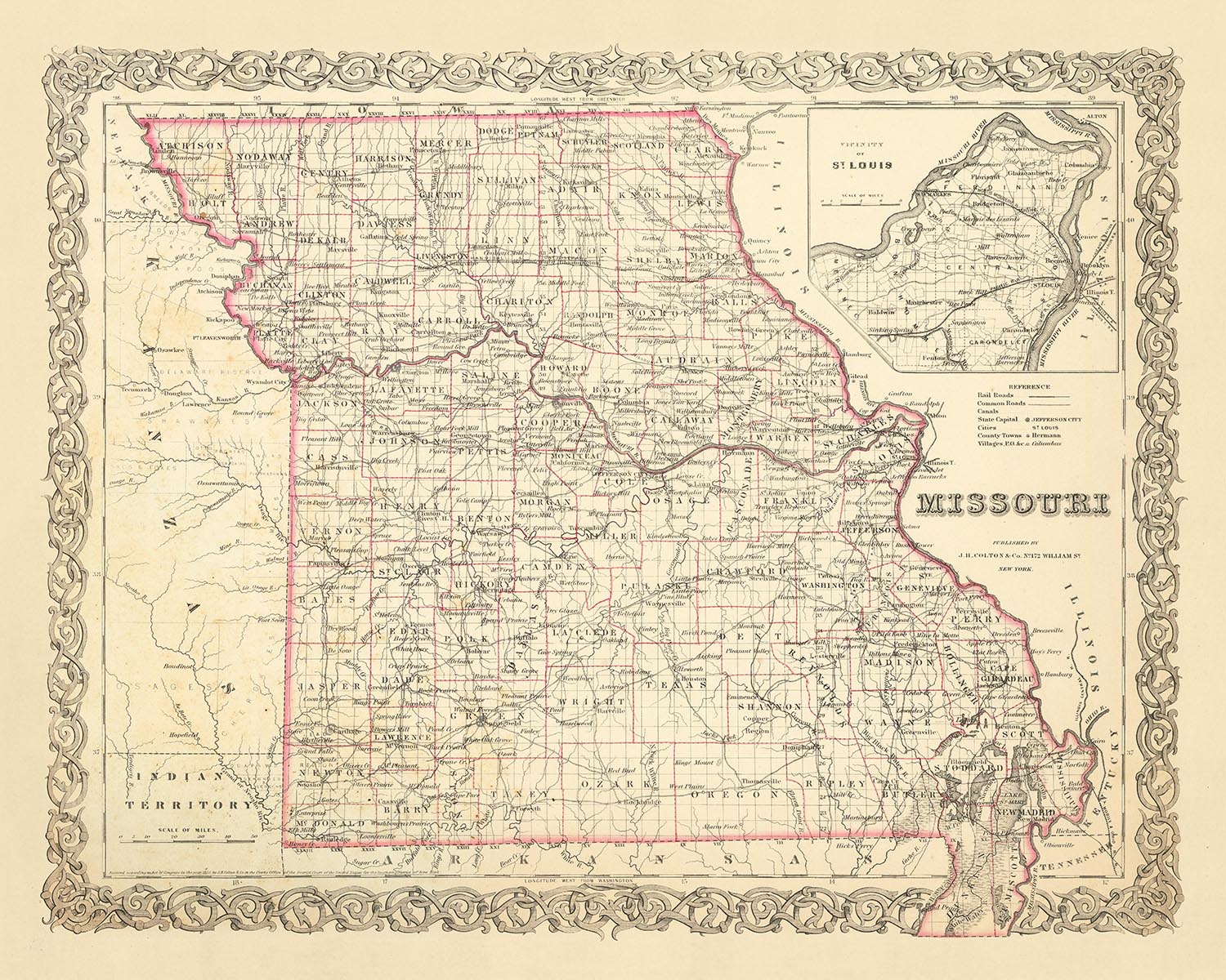
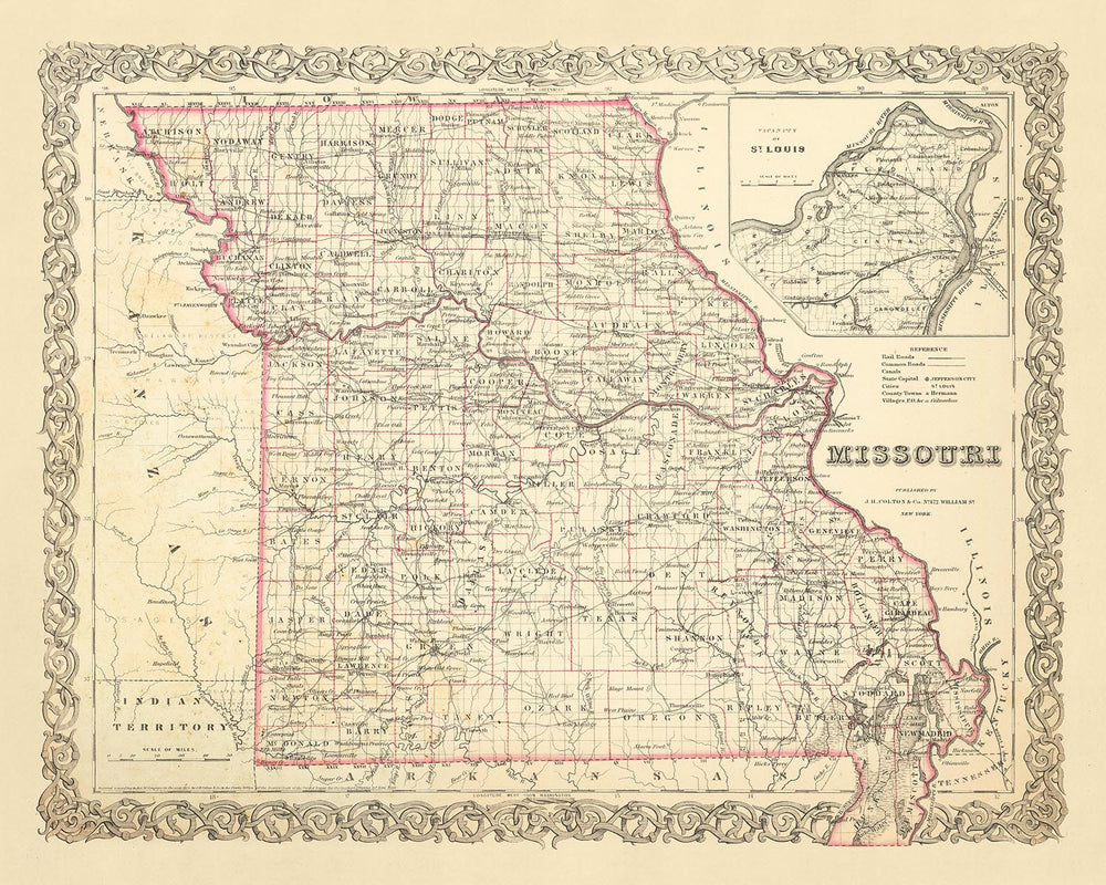


Mappa antica del Missouri di J. H. Colton, 1860: St. Louis, Kansas City, Springfield, Independence, Jefferson City
Compra 2, Ricevi 1 Gratuito
Se aggiungi 2 articoli al tuo carrello, puoi aggiungere un terzo prodotto gratuitamente.
Questo vale per tutte le mappe e opere d'arte, comprese le opere personalizzate e su misura. Puoi ordinare 3 dello stesso articolo, o 3 articoli diversi.
Questo equivale a uno sconto del 33%, che sarà il maggiore sconto disponibile nel mio negozio quest'anno.
Ti prego di approfittare dell'offerta e di coprire le tue pareti con bellissime mappe e opere d'arte!
Contattami se hai domande.
-
![]() Handmade locally in the EU
Handmade locally in the EU

-
FREE worldwide delivery in 2-3 days ⓘ
Free delivery in 2-3 days
Your map should be delivered in 2-3 working days with free delivery, worldwide.
We make maps by hand locally in 23 countries, including the EU
![]() . If you're buying a gift for someone in another country, we will make the map locally to them.
. If you're buying a gift for someone in another country, we will make the map locally to them.You will never pay import tax or customs duty.
Express delivery is available at checkout which can reduce the delivery time to 1-2 days.
Please note that personalised maps, and larger framed maps, can take longer to produce and deliver.
If you need your order to arrive by a certain date, contact me and we can discuss your options.
-
Complimentary gifting & design advice
ⓘ
Complimentary gifting & design advice
Available almost 24/7 on WhatsApp and email — we usually reply within minutes. We can help you:
- Choose a perfectly personalised gift
- Send a digital gift preview to the recipient
- Pick the ideal size for your wall
- Select the right finish and frame
Quick, friendly advice so you can order with confidence.
For last minute gifts, consider buying a digital gift card. We have over 5,000 maps and art prints to choose from.
-
90-day returns & 5-year guarantee
ⓘ
90 giorni per restituire e ricevere un rimborso
I prodotti possono essere restituiti entro 90 giorni per un rimborso completo, o cambio con un altro prodotto.
Per articoli personalizzati e su misura, potremmo offrirti un credito in negozio o una carta regalo non scadente, poiché non possiamo rivendere ordini personalizzati.
Se hai domande, contattaci. Per ulteriori informazioni, consulta la nostra politica di restituzione e cambio.

This is a museum-grade archival print from the original 1860 map — restored in our workshop and made to order on 220gsm archival matte paper or 400gsm artist's cotton canvas with pigment inks.
Professional framing & free personalisation available.
1. Choose a size
2. Frame & personalise your map
Make your map unique with framing, hand-drawn customisation, vintage ageing, pop art text, unique 3D styling and more.


Gift message & custom finish

If you want to add a gift message, or a finish (jigsaw, aluminium board, etc.) that is not available here, please request it in the "order note" when you check out.
Every order is custom made, so if you need the size adjusted slightly, or printed on an unusual material, just let us know. We've done thousands of custom orders over the years, so there's (almost) nothing we can't manage.
You can also contact us before you order, if you prefer!

- Handmade locally. No import duty or tax
- FREE worldwide delivery
- 90-day returns & 5-year product guarantee
- Questions? WhatsApp me any time
Own a piece of history
7,000+ 5 star reviews


Immergiti nel passato affascinante degli Stati Uniti con questa mappa antica e affascinante del Missouri, realizzata con cura dal rinomato cartografo J. H. Colton nel 1860. Questo pezzo offre uno sguardo unico su un periodo formativo della storia americana, un'epoca in cui la nazione era ancora nella sua infanzia e il paesaggio del Missouri era notevolmente diverso da quello che conosciamo oggi. È una testimonianza straordinaria del inarrestabile passare del tempo, un promemoria di quanto siamo arrivati lontano e di quanto è cambiato negli ultimi 150 anni.
Questa mappa è un tesoro di dettagli storici, che mostra il Missouri di un tempo con i cinque insediamenti più notevoli dell'epoca: St. Louis, Kansas City, Springfield, Independence e Jefferson City. Ognuno di questi luoghi occupa un posto significativo nella storia dello stato, e questa mappa funge da testimonianza del loro lascito duraturo. È un invito a viaggiare indietro nel tempo, per esplorare le radici di questi insediamenti e immaginare come potesse essere la vita nel cuore dell'America durante la metà del XIX secolo.
Ciò che distingue questa mappa è la sua origine nelle mani di J. H. Colton, ampiamente considerato il miglior cartografo americano della sua epoca. L'attenzione meticolosa di Colton ai dettagli e il suo impegno per l'accuratezza sono evidenti in ogni centimetro di questa mappa. È una testimonianza della sua abilità e artigianato, un pezzo di storia che non solo ritrae il passato ma racconta anche una storia sull'arte della cartografia stessa.
Esplorando questa mappa, scoprirai una ricchezza di dettagli affascinanti. Nota come i confini e i nomi dei luoghi possano essere cambiati nel corso degli anni, riflettendo l'evoluzione del panorama politico e culturale dell'epoca. Questa mappa è una finestra sul passato, offrendo una prospettiva unica sulla storia degli Stati Uniti e dello stato del Missouri. È un pezzo straordinario di storia, perfetto per qualsiasi collezionista o appassionato di storia.
In conclusione, questa mappa antica del Missouri di J. H. Colton è più di un semplice artefatto storico. È un viaggio nel passato, una celebrazione dell'arte della cartografia e un tributo all'eredità duratura degli insediamenti che hanno plasmato lo stato del Missouri. È un pezzo di storia che puoi esplorare, riflettere e apprezzare, una testimonianza del viaggio straordinario che ci ha portato dove siamo oggi.
Insediamenti del Missouri
- St. Louis (1764): Conosciuta come la "Porta verso Ovest," St. Louis era un importante porto sul fiume Mississippi e il punto di partenza per l'Expedition Lewis e Clark.
- Kansas City (1838): Originariamente chiamata Town of Kansas, divenne un nodo cruciale per l'espansione verso ovest grazie alla sua posizione strategica sul fiume Missouri.
- Springfield (1830): Conosciuta come la "Città Regina degli Ozarks," Springfield fu un sito chiave durante la Guerra Civile.
- Independence (1827): Il punto di partenza per il Sentiero dell'Oregon e la città natale del presidente Harry S. Truman.
- Jefferson City (1821): Prende il nome da Thomas Jefferson, divenne la capitale dello stato nel 1826.
- Columbia (1821): Sede dell'Università del Missouri, la prima università pubblica a ovest del fiume Mississippi.
- Hannibal (1819): Città natale di Mark Twain e ambientazione dei suoi romanzi "Le avventure di Tom Sawyer" e "Le avventure di Huckleberry Finn."
- Boonville (1810): Una posizione chiave sul Sentiero di Santa Fe.
- Cape Girardeau (1793) : Conosciuta come "La Città delle Rose," era una roccaforte strategica dell'Unione durante la Guerra Civile.
- Liberty (1822): Luogo del primo furto in banca diurno negli Stati Uniti.
- St. Charles (1769): Conosciuta come Les Petites Côtes, è stata la prima capitale statale del Missouri.
- Weston (1837): Un tempo il secondo porto più grande del fiume Missouri e un importante punto di rifornimento per la corsa all'oro in California.
- Sedalia (1857): Nota per ospitare la Fiera Statale del Missouri dal 1901.
- Neosho (1839): Conosciuta come la "Porta degli Ozark" e il luogo della Convenzione Statale del Missouri pro-Sud durante la Guerra Civile.
- St. Joseph (1843): Il punto di partenza del Pony Express e il luogo di morte di Jesse James.
- Fayette (1823): Sede della Central Methodist University, uno dei college più antichi a ovest del Mississippi.
- Marshall (1839): Prende il nome dal Giudice Capo della Corte Suprema John Marshall.
- Carthage (1842): Luogo della Battaglia di Carthage, un primo scontro nella Guerra Civile.
- Jackson (1814): Prende il nome dal Presidente Andrew Jackson, è stato un importante centro per il Distretto di Piombo del Sud-Est del Missouri.
- Lexington (1822): Nota per la sua architettura storica e la Battaglia di Lexington durante la Guerra Civile.
Tribù Native American
- Nazione Osage: La tribù dominante nel Missouri all'inizio del XIX secolo, nota per la sua cultura guerriera.
- Tribù Missouria: La tribù che ha dato il nome al Missouri, in gran parte dislocata al momento di questa mappa.
- Tribù Otoe: Originariamente parte della tribù Winnebago nella regione dei Grandi Laghi, migrarono verso ovest nel Missouri e in Nebraska.
Caratteristiche Naturali
- Fiume Mississippi: Il secondo fiume più lungo del Nord America, una importante via di trasporto per secoli.
- Fiume Missouri: Il fiume più lungo del Nord America, esplorato da Lewis e Clark.
- Monti Ozark: Noti per la loro bellezza naturale, con numerose aree ricreative e parchi.
- Foresta Nazionale di Mark Twain: Istituita molto tempo dopo questa mappa, ma l'area era nota per le sue estese foreste di latifoglie.
Eventi Storici
- Compromesso del Missouri (1820): Ha ammesso il Missouri come stato schiavista e il Maine come stato libero, mantenendo l'equilibrio di potere nel Senato.
- Caso Dred Scott (1857): Un caso storico della Corte Suprema originato a St. Louis, che ha stabilito che gli afroamericani non potevano essere cittadini statunitensi.
- Legge Kansas-Nebraska (1854): Ha portato a conflitti violenti lungo il confine Missouri-Kansas sulla questione della schiavitù, noto come "Kansas insanguinato."
Si prega di controllare attentamente le immagini per assicurarsi che una specifica città o luogo sia mostrato su questa mappa. È anche possibile contattarci e chiedere di controllare la mappa per te.
Questa mappa appare ottima in tutte le dimensioni: 12x16in (30.5x41cm), 16x20in (40.5x51cm), 18x24in (45.5x61cm), 24x30in (61x76cm), 32x40in (81.5x102cm), 40x50in (102x127cm), 48x60in (122x153cm) e 56x70in (142x178cm), ma appare ancora meglio quando stampata in grande.
Posso creare bellissime stampe di grande formato di questa mappa fino a 70in (178cm). Si prega di contattarci se si cercano opzioni di incorniciatura più grandi, personalizzate o diverse.
Il modello nelle immagini dell'elenco tiene in mano la versione di questa mappa 16x20in (40.5x51cm).
L'immagine di elenco numero cinque mostra un esempio del mio servizio di personalizzazione della mappa.
Se stai cercando qualcosa di leggermente diverso, dai un'occhiata alla mia principale collezione di mappe degli Stati Uniti e del Nord America.
Per favore contattami per verificare se una certa posizione, un monumento o una caratteristica è mostrata su questa mappa.
Questo sarebbe un meraviglioso regalo per un compleanno, Natale, Festa del Papà, partenza dal lavoro, anniversario o inaugurazione della casa per qualcuno delle aree coperte da questa mappa.
Questa mappa è disponibile come stampa giclée su carta opaca archiviata senza acidi, oppure puoi acquistarla incorniciata. La cornice è una semplice cornice nera che si adatta alla maggior parte degli stili. Per favore contattami se desideri un colore o un materiale di cornice diverso. Le mie cornici sono dotate di un vetro acrilico (perspex/acrylite) super chiaro di grado museale, che è significativamente meno riflettente del vetro, più sicuro e arriverà sempre in perfette condizioni.
This map is also available as a float framed canvas, sometimes known as a shadow gap framed canvas or canvas floater. The map is printed on artist's cotton canvas and then stretched over a handmade box frame. We then "float" the canvas inside a wooden frame, which is available in a range of colours (black, dark brown, oak, antique gold and white). This is a wonderful way to present a map without glazing in front. See some examples of float framed canvas maps and explore the differences between my different finishes.
For something truly unique, this map is also available in "Unique 3D", our trademarked process that dramatically transforms the map so that it has a wonderful sense of depth. We combine the original map with detailed topography and elevation data, so that mountains and the terrain really "pop". For more info and examples of 3D maps, check my Unique 3D page.
For most orders, delivery time is about 3 working days. Personalised and customised products take longer, as I have to do the personalisation and send it to you for approval, which usually takes 1 or 2 days.
Please note that very large framed orders usually take longer to make and deliver.
If you need your order to arrive by a certain date, please contact me before you order so that we can find the best way of making sure you get your order in time.
I print and frame maps and artwork in 23 countries around the world. This means your order will be made locally, which cuts down on delivery time and ensures that it won't be damaged during delivery. You'll never pay customs or import duty, and we'll put less CO2 into the air.
All of my maps and art prints are well packaged and sent in a rugged tube if unframed, or surrounded by foam if framed.
I try to send out all orders within 1 or 2 days of receiving your order, though some products (like face masks, mugs and tote bags) can take longer to make.
If you select Express Delivery at checkout your order we will prioritise your order and send it out by 1-day courier (Fedex, DHL, UPS, Parcelforce).
Next Day delivery is also available in some countries (US, UK, Singapore, UAE) but please try to order early in the day so that we can get it sent out on time.
My standard frame is a gallery style black ash hardwood frame. It is simple and quite modern looking. My standard frame is around 20mm (0.8in) wide.
I use super-clear acrylic (perspex/acrylite) for the frame glass. It's lighter and safer than glass - and it looks better, as the reflectivity is lower.
Six standard frame colours are available for free (black, dark brown, dark grey, oak, white and antique gold). Custom framing and mounting/matting is available if you're looking for something else.
Most maps, art and illustrations are also available as a framed canvas. We use matte (not shiny) cotton canvas, stretch it over a sustainably sourced box wood frame, and then 'float' the piece within a wood frame. The end result is quite beautiful, and there's no glazing to get in the way.
All frames are provided "ready to hang", with either a string or brackets on the back. Very large frames will have heavy duty hanging plates and/or a mounting baton. If you have any questions, please get in touch.
See some examples of my framed maps and framed canvas maps.
Alternatively, I can also supply old maps and artwork on canvas, foam board, cotton rag and other materials.
If you want to frame your map or artwork yourself, please read my size guide first.
Alcune delle mie vecchie mappe sono ora disponibili come tele incorniciate. Per favore contattami se desideri ordinare una dimensione che non è disponibile nel mio negozio.
Le vecchie mappe su tela sono un'alternativa interessante alle mappe incorniciate in modo convenzionale. A seconda del tuo gusto personale e dell'arredamento della stanza, le mappe su tela possono "risaltare" un po' di più rispetto a una mappa incorniciata.
My maps are extremely high quality reproductions of original maps.
I source original, rare maps from libraries, auction houses and private collections around the world, restore them at my London workshop, and then use specialist giclée inks and printers to create beautiful maps that look even better than the original.
My maps are printed on acid-free archival matte (not glossy) paper that feels very high quality and almost like card. In technical terms the paper weight/thickness is 10mil/200gsm. It's perfect for framing.
I print with Epson ultrachrome giclée UV fade resistant pigment inks - some of the best inks you can find.
I can also make maps on canvas, cotton rag and other exotic materials.
Learn more about The Unique Maps Co.
Map personalisation
If you're looking for the perfect anniversary or housewarming gift, I can personalise your map to make it truly unique. For example, I can add a short message, or highlight an important location, or add your family's coat of arms.
The options are almost infinite. Please see my map personalisation page for some wonderful examples of what's possible.
To order a personalised map, select "personalise your map" before adding it to your basket.
Get in touch if you're looking for more complex customisations and personalisations.
Map ageing
I have been asked hundreds of times over the years by customers if they could buy a map that looks even older.
Well, now you can, by selecting Aged before you add a map to your basket.
All the product photos you see on this page show the map in its Original form. This is what the map looks like today.
If you select Aged, I will age your map by hand, using a special and unique process developed through years of studying old maps, talking to researchers to understand the chemistry of aging paper, and of course... lots of practice!
If you're unsure, stick to the Original colour of the map. If you want something a bit darker and older looking, go for Aged.
Se non sei soddisfatto del tuo ordine per qualsiasi motivo, contattami per un rimborso senza problemi. Si prega di consultare la nostra politica di reso e rimborso per ulteriori informazioni.
Sono molto sicuro che ti piacerà la tua mappa restaurata o la stampa d'arte. Lo faccio dal 1984. Sono un venditore Etsy a 5 stelle. Ho venduto decine di migliaia di mappe e stampe d'arte e ho oltre 5.000 recensioni reali a 5 stelle.
Utilizzo un processo unico per restaurare mappe e opere d'arte che richiede molto tempo e lavoro. Trovare le mappe e le illustrazioni originali può richiedere mesi. Utilizzo tecnologia all'avanguardia e incredibilmente costosa per scannerizzare e restaurarle. Di conseguenza, garantisco che le mie mappe e stampe d'arte siano superiori alle altre - ecco perché posso offrire un rimborso senza problemi.
Quasi tutte le mie mappe e stampe d'arte sembrano fantastiche a grandi dimensioni (200 cm, 6,5 piedi+) e posso anche incorniciarle e consegnarle a te, tramite un corriere speciale per oggetti di grandi dimensioni. Contattami per discutere delle tue esigenze specifiche.
Or try searching for something!


