

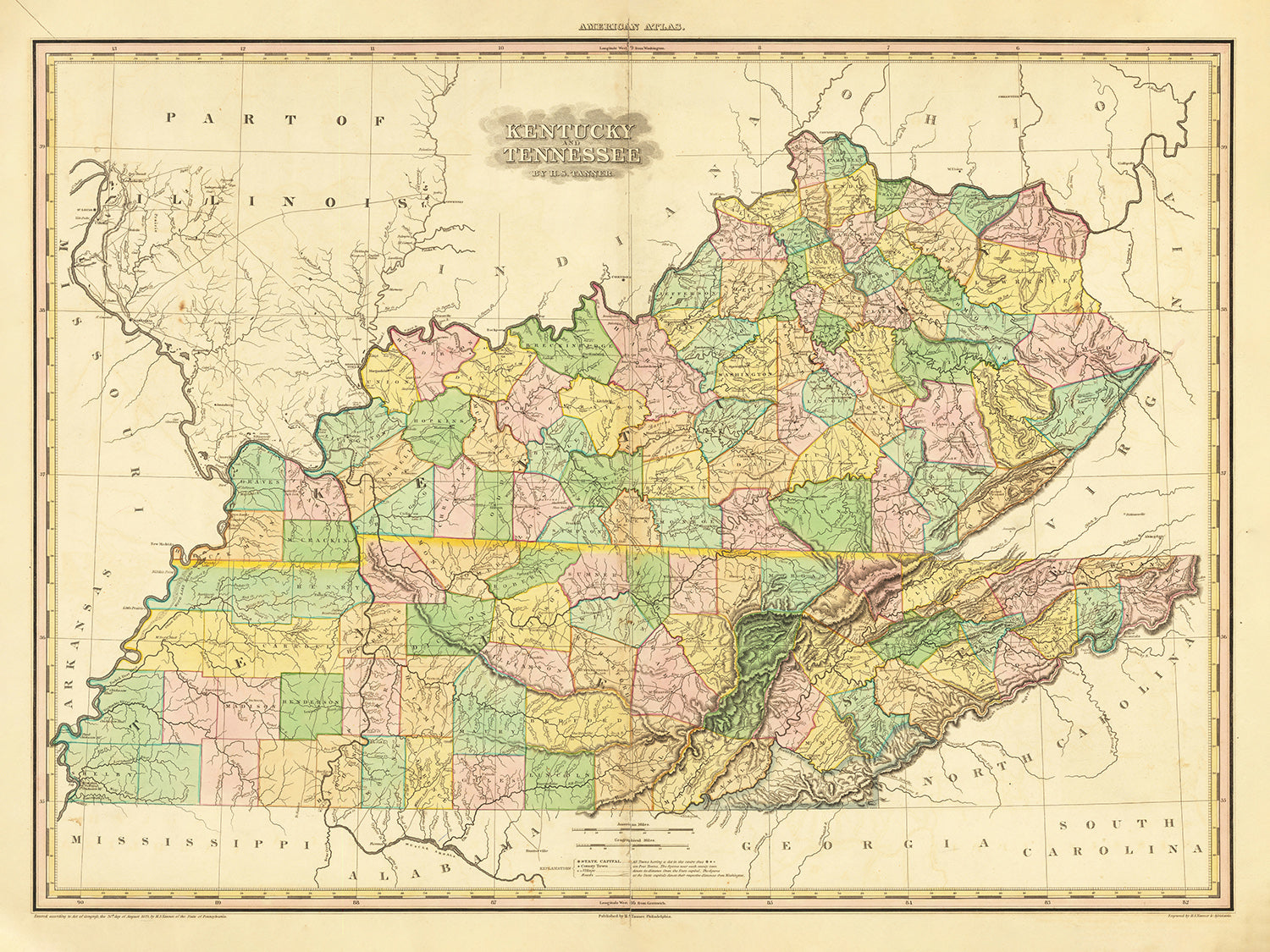


Antica mappa del Kentucky e del Tennessee di H.S. Tanner, 1820, con Nashville, Louisville, Lexington, Knoxville e Chattanooga
Compra 2, Ricevi 1 Gratuito
Se aggiungi 2 articoli al tuo carrello, puoi aggiungere un terzo prodotto gratuitamente.
Questo vale per tutte le mappe e opere d'arte, comprese le opere personalizzate e su misura. Puoi ordinare 3 dello stesso articolo, o 3 articoli diversi.
Questo equivale a uno sconto del 33%, che sarà il maggiore sconto disponibile nel mio negozio quest'anno.
Ti prego di approfittare dell'offerta e di coprire le tue pareti con bellissime mappe e opere d'arte!
Contattami se hai domande.

-
![]() Handmade locally in the EU
Handmade locally in the EU
-
FREE worldwide delivery in 2-3 days ⓘ
Free delivery in 2-3 days
Your map should be delivered in 2-3 working days with free delivery, worldwide.
Deliveries over the Christmas and New Year period may be slightly delayed, as couriers and postal services catch up with a huge backlog of packages.
We make maps by hand locally in 23 countries, including the EU
![]() . If you're buying a gift for someone in another country, we will make the map locally to them.
. If you're buying a gift for someone in another country, we will make the map locally to them.You will never pay import tax or customs duty.
Express delivery is available at checkout which can reduce the delivery time to 1-2 days.
Please note that personalised maps, and larger framed maps, can take longer to produce and deliver.
If you need your order to arrive by a certain date, contact me and we can discuss your options.
-
FREE gift preview
ⓘ
Digital gift preview
After you complete your order, you can send a beautiful digital preview to the gift recipient. Just provide their email address and we'll do the rest. (Their email address will not be stored or used for any other purpose.)
This is perfect if you're concerned that your order might not arrive in time.
You can also buy a real non-expiring gift card, and email it directly to the recipient, so they can buy their own map or artwork.
-
90 day money back guarantee
ⓘ
90 giorni per restituire e ricevere un rimborso
I prodotti possono essere restituiti entro 90 giorni per un rimborso completo, o cambio con un altro prodotto.
Per articoli personalizzati e su misura, potremmo offrirti un credito in negozio o una carta regalo non scadente, poiché non possiamo rivendere ordini personalizzati.
Se hai domande, contattaci. Per ulteriori informazioni, consulta la nostra politica di restituzione e cambio.

My maps are rare, museum-grade, restored old maps sourced from libraries, auction houses and private collections across the globe.
Framing & free personalisation available
1. Select your size
Click here to order a custom size.
2. Frame & personalise your map
Make your map unique with framing, hand-drawn customisation, vintage ageing, pop art text, unique 3D styling and more.


Gift message & custom finish

If you want to add a gift message, or a finish (jigsaw, aluminium board, etc.) that is not available here, please request it in the "order note" when you check out.
Every order is custom made, so if you need the size adjusted slightly, or printed on an unusual material, just let us know. We've done thousands of custom orders over the years, so there's (almost) nothing we can't manage.
You can also contact us before you order, if you prefer!

- Handmade locally. No import duty or tax
- FREE worldwide delivery
- Love it or your money back (90 days)
- Questions? WhatsApp me any time
Own a piece of history
5,000+ 5 star reviews


Immergiti nel fascino del passato con questa squisita mappa del 1820 del Kentucky e del Tennessee di H. S. Tanner. Un pezzo di storia inestimabile, questa mappa offre una finestra su un'epoca formativa nello sviluppo di queste regioni significative. Realizzata con un occhio squisito per i dettagli e una profonda comprensione della geografia, questo pezzo antico è più di una mappa: è un vivace arazzo tessuto con i fili della storia americana precoce.
Come un prezioso reperto del passato, questa mappa evidenzia una serie di insediamenti che hanno contribuito alla ricchezza della storia del Kentucky e del Tennessee. Ogni luogo segnato su questa mappa racconta una storia a sé stante, con alcuni che sono centri di commercio, sedi di potere o hub di assimilazione culturale.
Gli insediamenti chiave nel Kentucky includono:
- Louisville (1778): Fondata da George Rogers Clark, è una delle città più antiche a ovest delle Montagne Appalache.
- Lexington (1775): Fondata nel 1775, Lexington è stata nominata in onore delle Battaglie di Lexington e Concord nel Massachusetts.
- Frankfort (1786): Nota per essere la capitale dello stato e per il suo centro storico.
- Paducah (1827): Riconosciuta per la sua posizione strategica alla confluenza dei fiumi Tennessee e Ohio.
- Owensboro (1817): Nota per la sua vivace scena musicale bluegrass e la ricca cultura del barbecue.
- Bowling Green (1798): Nota per la sua importanza storica durante la Guerra Civile.
- Covington (1815): Famosa per i suoi storici quartieri ben conservati.
- Hopkinsville (1796): Nota per il suo festival annuale 'Little Green Men' che celebra un presunto incontro alieno nel 1955.
- Richmond (1798): Nota per la Battaglia di Richmond durante la Guerra Civile.
- Madisonville (1807): Nota per la sua ricca storia mineraria del carbone.
- Elizabethtown (1797): Nota per essere un gateway verso il Bourbon Trail.
- Cumberland (1826): Nominata dopo il fiume Cumberland, è nota per la sua storica industria mineraria del carbone.
- Glasgow (1799): Nota per i suoi annuali Scottish Highland Games.
- Pikeville (1822): Nota per il feudale storico tra le famiglie Hatfield e McCoy.
- Berea (1855): Nota per il Berea College, il primo college coeducativo e razzialmente integrato nel Sud.
Gli insediamenti chiave nel Tennessee includono:
- Nashville (1779): Conosciuta come la "Music City", è stata fondata da James Robertson e John Donelson e ha servito come un importante luogo per l'industria musicale, specialmente la musica country.
- Knoxville (1791): Questa città è nota come la prima capitale del Tennessee.
- Chattanooga (1816): Chattanooga è stata una città importante per le sue ferrovie che hanno giocato un ruolo significativo nella Guerra Civile.
- Clarksville (1785): Nominata in onore dell'eroe della Guerra d'Indipendenza generale George Rogers Clark.
- Jackson (1821): Nominata dopo il presidente Andrew Jackson, questa città era un centro per l'industria ferroviaria nel XIX secolo.
- Murfreesboro (1811): È stata la capitale del Tennessee dal 1818 al 1826.
- Bristol (1852): Riconosciuta come il luogo di nascita della musica country.
- Gallatin (1802): Nota per i suoi numerosi siti preistorici e piantagioni storiche.
- Lebanon (1801): Famosa per la sua Fiera della Contea di Wilson, una delle più grandi del Tennessee.
- Smyrna (1819): Nota per la sua ricca storia della Guerra Civile.
- Greeneville (1783): Nota come la casa del presidente Andrew Johnson.
- Sevierville (1795): Nota per essere la città natale di Dolly Parton.
- Shelbyville (1810): Conosciuta come la "Capitale del Cavallo da Passeggio del Mondo."
Le caratteristiche naturali notevoli includono:
- Cumberland Gap: Un passo attraverso le Montagne Cumberland utilizzato dai Nativi Americani e dai primi coloni, e ora parte del Cumberland Gap National Historical Park.
- Mammoth Cave: Il sistema di grotte più lungo conosciuto al mondo, situato nel Kentucky centrale, e una popolare attrazione turistica.
- Great Smoky Mountains: La catena montuosa che costeggia il confine tra Tennessee e Carolina del Nord, sede del Great Smoky Mountains National Park, il parco nazionale più visitato degli Stati Uniti.
- Fiume Kentucky: La principale via d'acqua nel Kentucky centrale, nota per le sue belle palizzate.
Nel periodo dal 1815 al 1820, la regione ha vissuto sviluppi significativi come:
- Il charter della Transylvania University a Lexington, Kentucky nel 1818.
- L'ammissione dell'Illinois nell'Unione nel 1818, ridefinendo il confine settentrionale del Kentucky.
- La creazione della Western and Atlantic Railroad a Chattanooga, Tennessee nel 1836, che sarebbe diventato un punto logistico critico nella Guerra Civile Americana.
Immergiti in un'epoca passata con questa mappa antica di Kentucky e Tennessee, dettagliata e realizzata da H. S. Tanner. Con le sue intricate rappresentazioni di insediamenti e caratteristiche topografiche, questa mappa ti invita a un viaggio attraverso la storia, catturando un momento cruciale nei primi giorni di questi due stati vibranti. Esplora il passato, ammira l'arte e apprezza le storie incise in questo raro e prezioso pezzo del patrimonio americano.
Ti preghiamo di controllare le immagini per assicurarti che una specifica città o luogo sia mostrato su questa mappa. Puoi anche contattarci e chiedere di controllare la mappa per te.
Questa mappa appare fantastica in tutte le dimensioni: 12x16in (30.5x41cm), 18x24in (45.5x61cm), 16x20in (40.5x51cm), 24x36in (61x91.5cm), 30x40in (76x101.5cm), 37x50in (94x127cm), 45x60in (114x152.5cm) e 52x70in (132x178cm), ma appare ancora meglio se stampata in grande.
Posso creare stampe grandi e belle di questa mappa fino a 100in (254cm). Ti preghiamo di contattarci se stai cercando opzioni di incorniciatura più grandi, personalizzate o diverse.
Il modello nelle immagini dell'inserzione tiene la versione di questa mappa 18x24in (45.5x61cm).
La quinta immagine dell'inserzione mostra un esempio del mio servizio di personalizzazione della mappa.
Se stai cercando qualcosa di leggermente diverso, dai un'occhiata alla mia principale collezione di mappe degli USA e del Nord America.
Ti preghiamo di contattarmi per verificare se una certa posizione, punto di riferimento o caratteristica è mostrata su questa mappa.
Questo sarebbe un meraviglioso regalo di compleanno, Natale, Festa del Papà, per un congedo dal lavoro, anniversario o per una festa di inaugurazione per qualcuno delle aree coperte da questa mappa.
Questa mappa è disponibile come stampa giclée su carta opaca archiviabile priva di acidi, oppure puoi acquistarla incorniciata. La cornice è una semplice cornice nera che si adatta alla maggior parte degli stili. Ti preghiamo di contattarci se desideri un colore o un materiale di cornice diverso. Le mie cornici sono dotate di un acrilico (perspex/acrylite) super chiaro di grado museale, che è significativamente meno riflettente del vetro, più sicuro e arriverà sempre in condizioni perfette.
This map is also available as a float framed canvas, sometimes known as a shadow gap framed canvas or canvas floater. The map is printed on artist's cotton canvas and then stretched over a handmade box frame. We then "float" the canvas inside a wooden frame, which is available in a range of colours (black, dark brown, oak, antique gold and white). This is a wonderful way to present a map without glazing in front. See some examples of float framed canvas maps and explore the differences between my different finishes.
For something truly unique, this map is also available in "Unique 3D", our trademarked process that dramatically transforms the map so that it has a wonderful sense of depth. We combine the original map with detailed topography and elevation data, so that mountains and the terrain really "pop". For more info and examples of 3D maps, check my Unique 3D page.
For most orders, delivery time is about 3 working days. Personalised and customised products take longer, as I have to do the personalisation and send it to you for approval, which usually takes 1 or 2 days.
Please note that very large framed orders usually take longer to make and deliver.
If you need your order to arrive by a certain date, please contact me before you order so that we can find the best way of making sure you get your order in time.
I print and frame maps and artwork in 23 countries around the world. This means your order will be made locally, which cuts down on delivery time and ensures that it won't be damaged during delivery. You'll never pay customs or import duty, and we'll put less CO2 into the air.
All of my maps and art prints are well packaged and sent in a rugged tube if unframed, or surrounded by foam if framed.
I try to send out all orders within 1 or 2 days of receiving your order, though some products (like face masks, mugs and tote bags) can take longer to make.
If you select Express Delivery at checkout your order we will prioritise your order and send it out by 1-day courier (Fedex, DHL, UPS, Parcelforce).
Next Day delivery is also available in some countries (US, UK, Singapore, UAE) but please try to order early in the day so that we can get it sent out on time.
My standard frame is a gallery style black ash hardwood frame. It is simple and quite modern looking. My standard frame is around 20mm (0.8in) wide.
I use super-clear acrylic (perspex/acrylite) for the frame glass. It's lighter and safer than glass - and it looks better, as the reflectivity is lower.
Six standard frame colours are available for free (black, dark brown, dark grey, oak, white and antique gold). Custom framing and mounting/matting is available if you're looking for something else.
Most maps, art and illustrations are also available as a framed canvas. We use matte (not shiny) cotton canvas, stretch it over a sustainably sourced box wood frame, and then 'float' the piece within a wood frame. The end result is quite beautiful, and there's no glazing to get in the way.
All frames are provided "ready to hang", with either a string or brackets on the back. Very large frames will have heavy duty hanging plates and/or a mounting baton. If you have any questions, please get in touch.
See some examples of my framed maps and framed canvas maps.
Alternatively, I can also supply old maps and artwork on canvas, foam board, cotton rag and other materials.
If you want to frame your map or artwork yourself, please read my size guide first.
Alcune delle mie vecchie mappe sono ora disponibili come tele incorniciate. Per favore contattami se desideri ordinare una dimensione che non è disponibile nel mio negozio.
Le vecchie mappe su tela sono un'alternativa interessante alle mappe incorniciate in modo convenzionale. A seconda del tuo gusto personale e dell'arredamento della stanza, le mappe su tela possono "risaltare" un po' di più rispetto a una mappa incorniciata.
My maps are extremely high quality reproductions of original maps.
I source original, rare maps from libraries, auction houses and private collections around the world, restore them at my London workshop, and then use specialist giclée inks and printers to create beautiful maps that look even better than the original.
My maps are printed on acid-free archival matte (not glossy) paper that feels very high quality and almost like card. In technical terms the paper weight/thickness is 10mil/200gsm. It's perfect for framing.
I print with Epson ultrachrome giclée UV fade resistant pigment inks - some of the best inks you can find.
I can also make maps on canvas, cotton rag and other exotic materials.
Learn more about The Unique Maps Co.
Map personalisation
If you're looking for the perfect anniversary or housewarming gift, I can personalise your map to make it truly unique. For example, I can add a short message, or highlight an important location, or add your family's coat of arms.
The options are almost infinite. Please see my map personalisation page for some wonderful examples of what's possible.
To order a personalised map, select "personalise your map" before adding it to your basket.
Get in touch if you're looking for more complex customisations and personalisations.
Map ageing
I have been asked hundreds of times over the years by customers if they could buy a map that looks even older.
Well, now you can, by selecting Aged before you add a map to your basket.
All the product photos you see on this page show the map in its Original form. This is what the map looks like today.
If you select Aged, I will age your map by hand, using a special and unique process developed through years of studying old maps, talking to researchers to understand the chemistry of aging paper, and of course... lots of practice!
If you're unsure, stick to the Original colour of the map. If you want something a bit darker and older looking, go for Aged.
Se non sei soddisfatto del tuo ordine per qualsiasi motivo, contattami per un rimborso senza problemi. Si prega di consultare la nostra politica di reso e rimborso per ulteriori informazioni.
Sono molto sicuro che ti piacerà la tua mappa restaurata o la stampa d'arte. Lo faccio dal 1984. Sono un venditore Etsy a 5 stelle. Ho venduto decine di migliaia di mappe e stampe d'arte e ho oltre 5.000 recensioni reali a 5 stelle.
Utilizzo un processo unico per restaurare mappe e opere d'arte che richiede molto tempo e lavoro. Trovare le mappe e le illustrazioni originali può richiedere mesi. Utilizzo tecnologia all'avanguardia e incredibilmente costosa per scannerizzare e restaurarle. Di conseguenza, garantisco che le mie mappe e stampe d'arte siano superiori alle altre - ecco perché posso offrire un rimborso senza problemi.
Quasi tutte le mie mappe e stampe d'arte sembrano fantastiche a grandi dimensioni (200 cm, 6,5 piedi+) e posso anche incorniciarle e consegnarle a te, tramite un corriere speciale per oggetti di grandi dimensioni. Contattami per discutere delle tue esigenze specifiche.
Or try searching for something!


