


Rara mappa antica delle Filippine di Bellin, 1752: Riduzione Rococò della mappa di Murillo Velarde
Compra 2, Ricevi 1 Gratuito
Se aggiungi 2 articoli al tuo carrello, puoi aggiungere un terzo prodotto gratuitamente.
Questo vale per tutte le mappe e opere d'arte, comprese le opere personalizzate e su misura. Puoi ordinare 3 dello stesso articolo, o 3 articoli diversi.
Questo equivale a uno sconto del 33%, che sarà il maggiore sconto disponibile nel mio negozio quest'anno.
Ti prego di approfittare dell'offerta e di coprire le tue pareti con bellissime mappe e opere d'arte!
Contattami se hai domande.
-
![]() Handmade locally in the EU
Handmade locally in the EU

-
FREE worldwide delivery in 2-3 days ⓘ
Free delivery in 2-3 days
Your map should be delivered in 2-3 working days with free delivery, worldwide.
We make maps by hand locally in 23 countries, including the EU
![]() . If you're buying a gift for someone in another country, we will make the map locally to them.
. If you're buying a gift for someone in another country, we will make the map locally to them.You will never pay import tax or customs duty.
Express delivery is available at checkout which can reduce the delivery time to 1-2 days.
Please note that personalised maps, and larger framed maps, can take longer to produce and deliver.
If you need your order to arrive by a certain date, contact me and we can discuss your options.
-
Complimentary gifting & design advice
ⓘ
Complimentary gifting & design advice
Available almost 24/7 on WhatsApp and email — we usually reply within minutes. We can help you:
- Choose a perfectly personalised gift
- Send a digital gift preview to the recipient
- Pick the ideal size for your wall
- Select the right finish and frame
Quick, friendly advice so you can order with confidence.
For last minute gifts, consider buying a digital gift card. We have over 5,000 maps and art prints to choose from.
-
90-day returns & 5-year guarantee
ⓘ
90 giorni per restituire e ricevere un rimborso
I prodotti possono essere restituiti entro 90 giorni per un rimborso completo, o cambio con un altro prodotto.
Per articoli personalizzati e su misura, potremmo offrirti un credito in negozio o una carta regalo non scadente, poiché non possiamo rivendere ordini personalizzati.
Se hai domande, contattaci. Per ulteriori informazioni, consulta la nostra politica di restituzione e cambio.

This is a museum-grade archival print from the original 1752 map — restored in our workshop and made to order on 220gsm archival matte paper or 400gsm artist's cotton canvas with pigment inks.
Professional framing & free personalisation available
1. Choose a size
2. Frame & personalise your map
Make your map unique with framing, hand-drawn customisation, vintage ageing, pop art text, unique 3D styling and more.


Gift message & custom finish

If you want to add a gift message, or a finish (jigsaw, aluminium board, etc.) that is not available here, please request it in the "order note" when you check out.
Every order is custom made, so if you need the size adjusted slightly, or printed on an unusual material, just let us know. We've done thousands of custom orders over the years, so there's (almost) nothing we can't manage.
You can also contact us before you order, if you prefer!

- Handmade locally. No import duty or tax
- FREE worldwide delivery
- 90-day returns & 5-year product guarantee
- Questions? WhatsApp me any time
Own a piece of history
7,000+ 5 star reviews


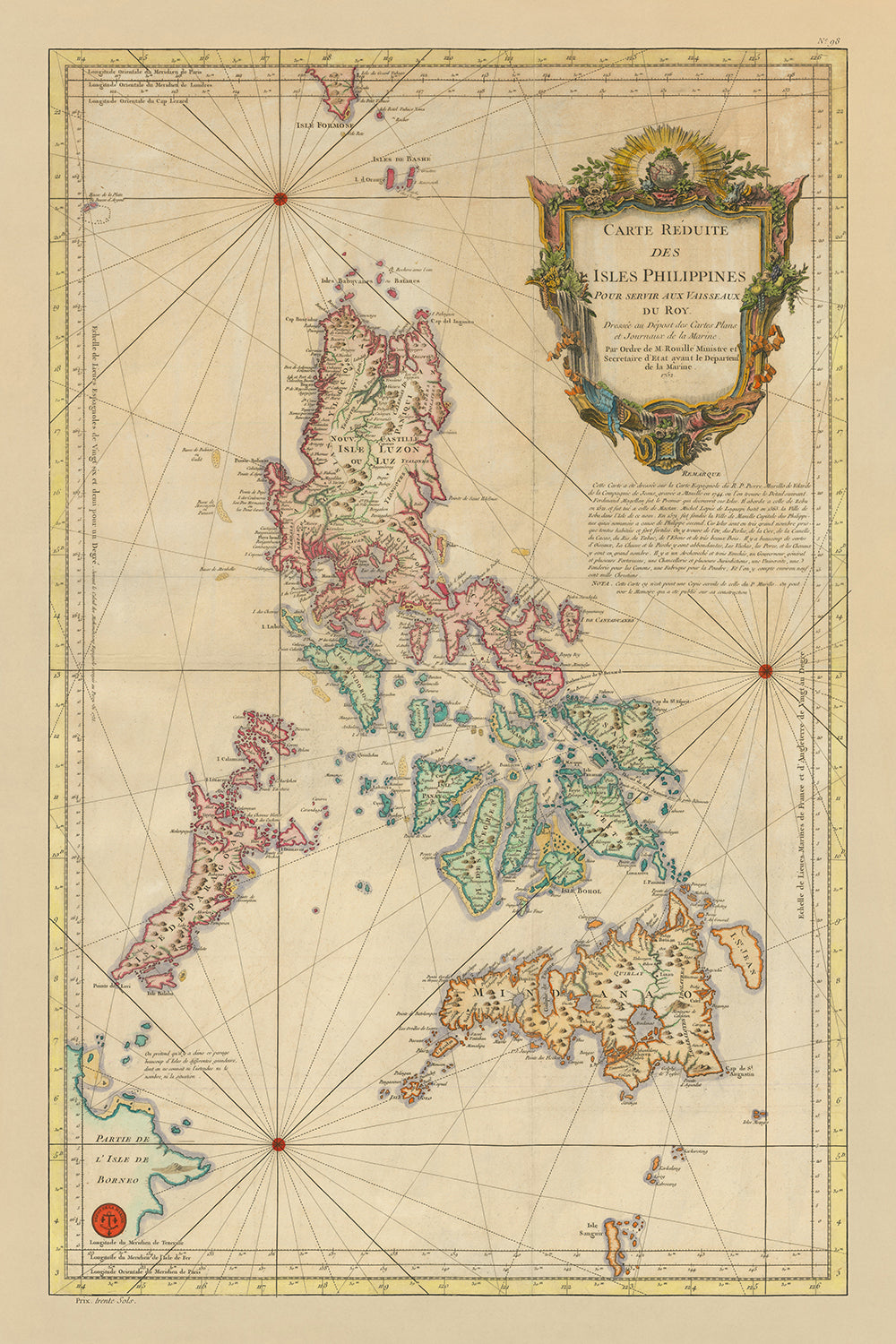
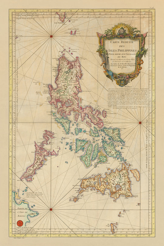
La "Carte Reduite des Isles Philippines Pour Servir Aux Vaisseaux du Roy Dressée au Dépost des Cartes Plans et Journaux de la Marine" è un'opera magistrale di Jacques-Nicolas Bellin, il rinomato idrografo della Marina Francese Reale. Realizzata nel 1752, questa mappa è una delle prime carte nautiche in grande formato dell'arcipelago filippino, che dettaglia meticolosamente le isole con un livello di precisione senza pari. L'opera di Bellin non è semplicemente un traguardo cartografico, ma un artefatto storico che cattura la geografia intricata e gli insediamenti delle Filippine in un periodo di significativa tensione politica ed esplorazione.
La mappa di Bellin è una testimonianza dell'approccio dettagliato e accademico della cartografia francese del XVIII secolo. La mappa si basa sul lavoro pionieristico di Padre Pedro Murillo Velarde, la cui mappa delle Filippine del 1744 è stata la prima rappresentazione ampiamente accurata delle isole. Bellin, pur attingendo pesantemente dal lavoro di Velarde, ha introdotto i propri miglioramenti, inclusa l'isola mitica di "St. Jean," riflettendo il mix di osservazione empirica e miti ereditati dell'epoca. La composizione elegante della mappa, adornata con un cartiglio del titolo rococò-neoclassico, è un piacere visivo che parla delle sensibilità artistiche del tempo.
La mappa è un ricco arazzo di geografia politica e fisica, etichettando tutti i principali insediamenti, fiumi e laghi. Cattura l'intero arcipelago filippino, dalla vivace città di Manila alle serene coste di Cebu e il posto strategico di Zamboanga. I mari che circondano le isole sono attraversati da linee di rotta, che indicano le rotte di navigazione essenziali per la Marina Francese. Questa rete di linee non solo aiuta nella navigazione marittima, ma aggiunge anche un elemento dinamico al design della mappa, simboleggiando l'interconnessione delle isole e del mondo più ampio.
La creazione di Bellin è più di uno strumento di navigazione; è un documento storico che fornisce un'idea del panorama geopolitico della metà del XVIII secolo. La mappa è stata prodotta durante un periodo di crescente tensione tra Francia e Gran Bretagna, che ha portato alla Guerra dei Sette Anni. In qualità di alleato della Spagna, il sovrano delle Filippine, la Francia aveva un interesse particolare a mantenere carte nautiche aggiornate e accurate. La mappa di Bellin faceva parte di questo sforzo strategico, assicurando che la Marina Francese fosse ben preparata per eventuali conflitti nella regione.
I dettagli intricati della mappa si estendono oltre le coste ai paesaggi interni, raffigurando catene montuose, fiumi e laghi con notevole precisione. Offre uno sguardo sulla bellezza naturale e la diversità delle isole filippine, dal terreno accidentato di Luzon alla lussureggiante vegetazione di Mindanao. Questo mix di geografia naturale e umana rende la mappa di Bellin una risorsa preziosa per storici, geografi e collezionisti, preservando un'istantanea delle Filippine così come veniva vista attraverso gli occhi di uno dei grandi cartografi della storia.
Città e paesi su questa mappa
- Manila
- Cebu
- Iloilo
- Zamboanga
- Vigan
- Laoag
- Legazpi
- Naga
- Tacloban
- Bacolod
- Davao
- Butuan
- Surigao
- Cagayan de Oro
- Cotabato
- Jolo
- Puerto Princesa
- Dumaguete
- Roxas
Caratteristiche e monumenti notevoli
- Illustrazioni:
- Grande cartiglio con design rococò-neoclassico.
- Corpi idrici:
- Numerosi mari e strette che circondano l'arcipelago filippino.
- Confini:
- Contorni delle isole filippine e delle regioni vicine.
- Montagne:
- Vari gruppi montuosi e picchi indicati all'interno delle isole.
- Altre caratteristiche notevoli:
- Linee di rotta che indicano le rotte di navigazione.
Contesto storico e di design
- Nome della mappa: Carte Reduite des Isles Philippines Pour Servir Aux Vaisseaux du Roy Dressée au Dépost des Cartes Plans et Journaux de la Marine
- Data di creazione: 1752
- Cartografo/Editore: Jacques-Nicolas Bellin
- Contesto sul cartografo: Jacques-Nicolas Bellin (1703-1772) era l'idrografo ufficiale della Marina Francese.
- Carta nautica in grande formato: Una delle prime mappe in grande formato ottenibili delle Filippine.
- Significato storico: Una delle opere fondamentali della mappatura delle Filippine, altamente dettagliata e basata sulle migliori fonti.
- Fonti: Basata sul lavoro di Padre Pedro Murillo Velarde, in particolare sulla sua mappa delle Filippine del 1744.
- Design e Stile: Presenta un grande cartiglio di titolo in uno stile rococò-neoclassico di transizione.
- Contesto politico: Prodotta durante un periodo di tensione politica, poco prima della Guerra dei Sette Anni (1756-63).
- Miglioramenti alla mappa: Include diverse aggiunte di Bellin, sebbene abbia reintrodotto l'isola mitica di "St. Jean".
- Temi mostrati sulla mappa:
- Mappa Politica e Fisica: Etichetta tutti i principali insediamenti, fiumi e laghi.
- Linee di rotta: I mari sono attraversati da numerose linee di rotta, che indicano le rotte di navigazione.
- Regioni mostrate sulla mappa:
- Arcipelago Filippino: Include l'intero arcipelago filippino.
- Regioni vicine: Parti del Borneo e di altre isole vicine.
- Significato storico:
- Esigenze Navali Francesi: Creata per fornire carte nautiche aggiornate per la Marina Francese.
- Evoluzione Cartografica: Riflette il processo di riconciliazione di prove e errori tra informazioni moderne e più antiche nella cartografia scientifica francese del XVIII secolo.
Si prega di controllare attentamente le immagini per assicurarsi che una specifica città o luogo sia mostrato su questa mappa. Puoi anche contattarci e chiedere di controllare la mappa per te.
Questa mappa appare ottima in ogni dimensione, ma consiglio sempre di optare per una dimensione più grande se hai spazio. In questo modo puoi facilmente distinguere tutti i dettagli.
Questa mappa appare incredibile in dimensioni fino a 100in (250cm). Se stai cercando una mappa più grande, per favore contattaci.
Si prega di notare: le etichette su questa mappa sono difficili da leggere se si ordina una mappa di 20 pollici (50 cm) o più piccola. La mappa è comunque molto attraente, ma se desideri leggere facilmente la mappa, ti preghiamo di acquistare una dimensione più grande.
Il modello nelle immagini dell'elenco tiene in mano la versione di questa mappa di 24x36 pollici (60x90 cm).
La quinta immagine dell'elenco mostra un esempio del mio servizio di personalizzazione della mappa.
Se stai cercando qualcosa di leggermente diverso, dai un'occhiata alla mia collezione dei migliori mappe antiche per vedere se qualcosa attira la tua attenzione.
Per favore contattami per verificare se una certa posizione, punto di riferimento o caratteristica è mostrata su questa mappa.
Questo sarebbe un meraviglioso regalo per un compleanno, Natale, Festa del Papà, un addio al lavoro, un anniversario o una festa di inaugurazione per qualcuno delle aree coperte da questa mappa.
Questa mappa è disponibile come stampa giclée su carta opaca archivistica priva di acidi, oppure puoi acquistarla incorniciata. La cornice è una semplice cornice nera che si adatta alla maggior parte degli stili. Per favore, contattami se desideri un colore o un materiale diverso per la cornice. Le mie cornici sono dotate di vetro acrilico super chiaro di grado museale (perspex/acrylite), che è significativamente meno riflettente del vetro, più sicuro e arriverà sempre in perfette condizioni.
This map is also available as a float framed canvas, sometimes known as a shadow gap framed canvas or canvas floater. The map is printed on artist's cotton canvas and then stretched over a handmade box frame. We then "float" the canvas inside a wooden frame, which is available in a range of colours (black, dark brown, oak, antique gold and white). This is a wonderful way to present a map without glazing in front. See some examples of float framed canvas maps and explore the differences between my different finishes.
For something truly unique, this map is also available in "Unique 3D", our trademarked process that dramatically transforms the map so that it has a wonderful sense of depth. We combine the original map with detailed topography and elevation data, so that mountains and the terrain really "pop". For more info and examples of 3D maps, check my Unique 3D page.
For most orders, delivery time is about 3 working days. Personalised and customised products take longer, as I have to do the personalisation and send it to you for approval, which usually takes 1 or 2 days.
Please note that very large framed orders usually take longer to make and deliver.
If you need your order to arrive by a certain date, please contact me before you order so that we can find the best way of making sure you get your order in time.
I print and frame maps and artwork in 23 countries around the world. This means your order will be made locally, which cuts down on delivery time and ensures that it won't be damaged during delivery. You'll never pay customs or import duty, and we'll put less CO2 into the air.
All of my maps and art prints are well packaged and sent in a rugged tube if unframed, or surrounded by foam if framed.
I try to send out all orders within 1 or 2 days of receiving your order, though some products (like face masks, mugs and tote bags) can take longer to make.
If you select Express Delivery at checkout your order we will prioritise your order and send it out by 1-day courier (Fedex, DHL, UPS, Parcelforce).
Next Day delivery is also available in some countries (US, UK, Singapore, UAE) but please try to order early in the day so that we can get it sent out on time.
My standard frame is a gallery style black ash hardwood frame. It is simple and quite modern looking. My standard frame is around 20mm (0.8in) wide.
I use super-clear acrylic (perspex/acrylite) for the frame glass. It's lighter and safer than glass - and it looks better, as the reflectivity is lower.
Six standard frame colours are available for free (black, dark brown, dark grey, oak, white and antique gold). Custom framing and mounting/matting is available if you're looking for something else.
Most maps, art and illustrations are also available as a framed canvas. We use matte (not shiny) cotton canvas, stretch it over a sustainably sourced box wood frame, and then 'float' the piece within a wood frame. The end result is quite beautiful, and there's no glazing to get in the way.
All frames are provided "ready to hang", with either a string or brackets on the back. Very large frames will have heavy duty hanging plates and/or a mounting baton. If you have any questions, please get in touch.
See some examples of my framed maps and framed canvas maps.
Alternatively, I can also supply old maps and artwork on canvas, foam board, cotton rag and other materials.
If you want to frame your map or artwork yourself, please read my size guide first.
Alcune delle mie vecchie mappe sono ora disponibili come tele incorniciate. Per favore contattami se desideri ordinare una dimensione che non è disponibile nel mio negozio.
Le vecchie mappe su tela sono un'alternativa interessante alle mappe incorniciate in modo convenzionale. A seconda del tuo gusto personale e dell'arredamento della stanza, le mappe su tela possono "risaltare" un po' di più rispetto a una mappa incorniciata.
My maps are extremely high quality reproductions of original maps.
I source original, rare maps from libraries, auction houses and private collections around the world, restore them at my London workshop, and then use specialist giclée inks and printers to create beautiful maps that look even better than the original.
My maps are printed on acid-free archival matte (not glossy) paper that feels very high quality and almost like card. In technical terms the paper weight/thickness is 10mil/200gsm. It's perfect for framing.
I print with Epson ultrachrome giclée UV fade resistant pigment inks - some of the best inks you can find.
I can also make maps on canvas, cotton rag and other exotic materials.
Learn more about The Unique Maps Co.
Map personalisation
If you're looking for the perfect anniversary or housewarming gift, I can personalise your map to make it truly unique. For example, I can add a short message, or highlight an important location, or add your family's coat of arms.
The options are almost infinite. Please see my map personalisation page for some wonderful examples of what's possible.
To order a personalised map, select "personalise your map" before adding it to your basket.
Get in touch if you're looking for more complex customisations and personalisations.
Map ageing
I have been asked hundreds of times over the years by customers if they could buy a map that looks even older.
Well, now you can, by selecting Aged before you add a map to your basket.
All the product photos you see on this page show the map in its Original form. This is what the map looks like today.
If you select Aged, I will age your map by hand, using a special and unique process developed through years of studying old maps, talking to researchers to understand the chemistry of aging paper, and of course... lots of practice!
If you're unsure, stick to the Original colour of the map. If you want something a bit darker and older looking, go for Aged.
Se non sei soddisfatto del tuo ordine per qualsiasi motivo, contattami per un rimborso senza problemi. Si prega di consultare la nostra politica di reso e rimborso per ulteriori informazioni.
Sono molto sicuro che ti piacerà la tua mappa restaurata o la stampa d'arte. Lo faccio dal 1984. Sono un venditore Etsy a 5 stelle. Ho venduto decine di migliaia di mappe e stampe d'arte e ho oltre 5.000 recensioni reali a 5 stelle.
Utilizzo un processo unico per restaurare mappe e opere d'arte che richiede molto tempo e lavoro. Trovare le mappe e le illustrazioni originali può richiedere mesi. Utilizzo tecnologia all'avanguardia e incredibilmente costosa per scannerizzare e restaurarle. Di conseguenza, garantisco che le mie mappe e stampe d'arte siano superiori alle altre - ecco perché posso offrire un rimborso senza problemi.
Quasi tutte le mie mappe e stampe d'arte sembrano fantastiche a grandi dimensioni (200 cm, 6,5 piedi+) e posso anche incorniciarle e consegnarle a te, tramite un corriere speciale per oggetti di grandi dimensioni. Contattami per discutere delle tue esigenze specifiche.
Or try searching for something!


