


Vecchia mappa della Frisia orientale di Visscher, 1690: Wilhelmshaven, Emden, Aurich, Leer, Riserva Naturale di Leyhörn
Compra 2, Ricevi 1 Gratuito
Se aggiungi 2 articoli al tuo carrello, puoi aggiungere un terzo prodotto gratuitamente.
Questo vale per tutte le mappe e opere d'arte, comprese le opere personalizzate e su misura. Puoi ordinare 3 dello stesso articolo, o 3 articoli diversi.
Questo equivale a uno sconto del 33%, che sarà il maggiore sconto disponibile nel mio negozio quest'anno.
Ti prego di approfittare dell'offerta e di coprire le tue pareti con bellissime mappe e opere d'arte!
Contattami se hai domande.
-
![]() Handmade locally in the EU
Handmade locally in the EU

-
FREE worldwide delivery in 2-3 days ⓘ
Free delivery in 2-3 days
Your map should be delivered in 2-3 working days with free delivery, worldwide.
We make maps by hand locally in 23 countries, including the EU
![]() . If you're buying a gift for someone in another country, we will make the map locally to them.
. If you're buying a gift for someone in another country, we will make the map locally to them.You will never pay import tax or customs duty.
Express delivery is available at checkout which can reduce the delivery time to 1-2 days.
Please note that personalised maps, and larger framed maps, can take longer to produce and deliver.
If you need your order to arrive by a certain date, contact me and we can discuss your options.
-
Complimentary gifting & design advice
ⓘ
Complimentary gifting & design advice
Available almost 24/7 on WhatsApp and email — we usually reply within minutes. We can help you:
- Choose a perfectly personalised gift
- Send a digital gift preview to the recipient
- Pick the ideal size for your wall
- Select the right finish and frame
Quick, friendly advice so you can order with confidence.
For last minute gifts, consider buying a digital gift card. We have over 5,000 maps and art prints to choose from.
-
90-day returns & 5-year guarantee
ⓘ
90 giorni per restituire e ricevere un rimborso
I prodotti possono essere restituiti entro 90 giorni per un rimborso completo, o cambio con un altro prodotto.
Per articoli personalizzati e su misura, potremmo offrirti un credito in negozio o una carta regalo non scadente, poiché non possiamo rivendere ordini personalizzati.
Se hai domande, contattaci. Per ulteriori informazioni, consulta la nostra politica di restituzione e cambio.

This is a museum-grade archival print from the original 1690 map — restored in our workshop and made to order on 220gsm archival matte paper or 400gsm artist's cotton canvas with pigment inks.
Professional framing & free personalisation available
1. Choose a size
2. Frame & personalise your map
Make your map unique with framing, hand-drawn customisation, vintage ageing, pop art text, unique 3D styling and more.


Gift message & custom finish

If you want to add a gift message, or a finish (jigsaw, aluminium board, etc.) that is not available here, please request it in the "order note" when you check out.
Every order is custom made, so if you need the size adjusted slightly, or printed on an unusual material, just let us know. We've done thousands of custom orders over the years, so there's (almost) nothing we can't manage.
You can also contact us before you order, if you prefer!

- Handmade locally. No import duty or tax
- FREE worldwide delivery
- 90-day returns & 5-year product guarantee
- Questions? WhatsApp me any time
Own a piece of history
7,000+ 5 star reviews


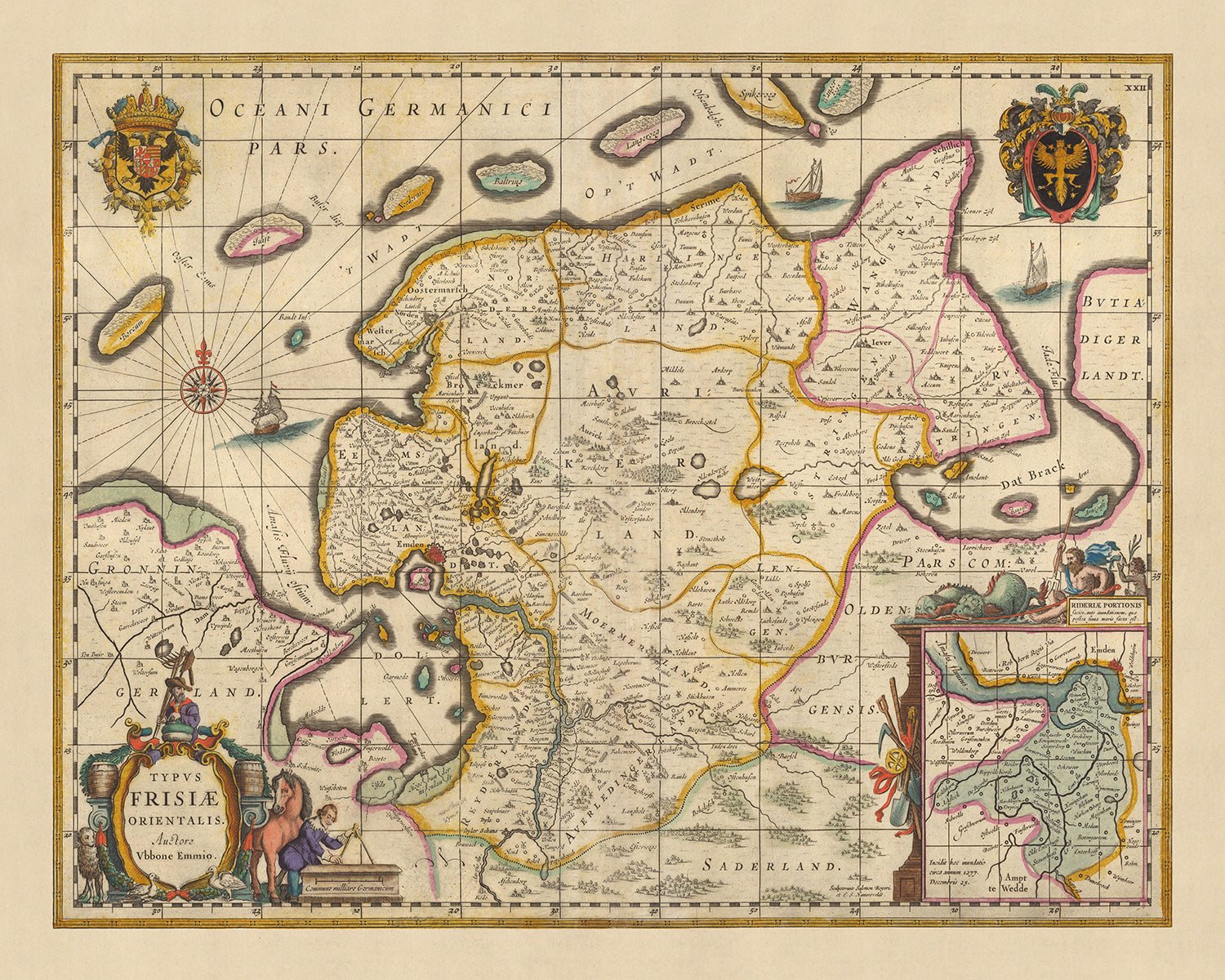
Immergiti nella ricca trama della storia con questa mappa meticolosamente dettagliata, 'Typus Frisiae Orientalis. Auctore Ubbone Emmio', di Nicolaes Visscher II, un rinomato cartografo dell'età dell'oro olandese. Creata nel 1690, questa mappa offre un affascinante spaccato dell'Est Frisia, una regione ora parte della Germania moderna.
Il nome completo della mappa si traduce in 'Tipo di Est Frisia. Autore Ubbo Emmius', indicando le specifiche regioni e divisioni politiche raffigurate su questa mappa. La mappa mostra la grandezza dell'Est Frisia, con le sue città vivaci e le riserve naturali intatte, offrendo una prospettiva unica sul passato della regione.
La mappa presenta diverse località notevoli tra cui Wilhelmshaven, una città conosciuta per il suo porto in acque profonde e la base navale; Emden, una città di grande significato storico a causa del suo ruolo nella Riforma protestante; Aurich, un tempo residenza del principe dell'Est Frisia; e Leer, una città affascinante che era un centro commerciale chiave nel XVII secolo. La mappa evidenzia anche la Riserva Naturale di Leyhörn, un testimone della ricca biodiversità della regione.
Il dettaglio meticoloso e l'accuratezza storica di questa mappa la rendono un must per gli appassionati di storia, i collezionisti di mappe e gli amanti della cartografia. Non solo fornisce un layout geografico, ma offre anche uno sguardo ai paesaggi politici, culturali e naturali dell'Est Frisia alla fine del XVII secolo. Questa mappa funge da finestra sul passato, permettendoti di esplorare la grandezza dell'Est Frisia dal comfort della tua casa.
Alcune delle località significative mostrate su questa mappa:
Est Frisia
- Wilhelmshaven: Una città conosciuta per il suo porto in acque profonde e la base navale.
- Emden: Una città di grande significato storico a causa del suo ruolo nella Riforma protestante.
- Aurich: Un tempo residenza del principe dell'Est Frisia.
- Leer: Una città affascinante che era un centro commerciale chiave nel XVII secolo.
- Norden: Conosciuta per le sue belle chiese e la Chiesa di Ludgeri che ospita un famoso organo Arp Schnitger.
- Jever: La città da cui proviene la famosa birra Jever Pilsener.
- Wittmund: Conosciuta per il suo centro storico ben conservato.
- Esens: Casa di Bensersiel, una popolare località balneare.
- Moormerland: Prende il nome dalla regione di Moormerland nell'Est Frisia.
- Wiesmoor: Conosciuta per la sua bella sala dei fiori.
- Uplengen: Casa di Remels, il suo distretto più grande con bellissimi mulini a vento.
- Hesel: Conosciuta per la Chiesa di San Martino nel centro della città.
- Rhauderfehn: Conosciuta per la sua cultura Fehn e i canali.
- Weener: Casa del ponte levatoio più grande del mondo.
- Borkum: La più grande e occidentale delle Isole Frisone Orientali.
- Norderney: Conosciuta per le sue spiagge sabbiose e la seconda più grande delle Isole Frisone Orientali.
- Juist: Conosciuta come la 'Terra delle Torri', una delle sette Isole Frisone Orientali abitate.
- Baltrum: La più piccola delle Isole Frisone Orientali.
- Langeoog: Conosciuta per il suo villaggio senza auto e una delle sette Isole Frisone Orientali abitate.
- Spiekeroog: Conosciuta per le sue belle dune e una delle sette Isole Frisone Orientali abitate.
- Wangerooge: L'isola più orientale delle Isole Frisone Orientali.
- Krummhörn: Conosciuta per i suoi pittoreschi villaggi e il Faro di Campen, il più alto della Germania.
- Südbrookmerland: Conosciuta per il Großes Meer, il lago interno più grande della Frisia Orientale.
- Ihlow: Conosciuta per le rovine del Monastero di Ihlow.
- Hinte: Conosciuta per il Castello di Loppersum, una storica villa signorile.
- Großefehn: Conosciuta per la sua cultura Fehn e i suoi bellissimi canali.
- Brookmerland: Conosciuta per la Chiesa di San Stefano nel villaggio di Engerhafe.
- Emden: Conosciuta per la Biblioteca Johannes a Lasco, una delle biblioteche più importanti della Riforma Calvinista.
- Aurich: Conosciuta per il Castello di Aurich, una ex residenza del principe frisone orientale.
- Leer: Conosciuta per il Leeraner Miniaturland, un'attrazione ferroviaria in miniatura.
Fenomeni Naturali Notabili
- Riserva Naturale Leyhörn: Un testimone della ricca biodiversità della regione.
- Mar di Wadden: Un Sito Patrimonio dell'Umanità UNESCO noto per la sua unica biodiversità ecologica.
- Baia di Dollart: Una baia nel Mar di Wadden tra i Paesi Bassi settentrionali e la Germania.
- Fiume Ems: Un importante fiume nel nord-ovest della Germania.
- Borkum Riff: Un importante pericolo per la navigazione al largo della costa della Frisia Orientale.
Eventi Storici Notabili (1600-1690)
- Guerra dei Trent'Anni (1618-1648): Una serie di guerre in Europa Centrale, che ha influito sulla Frisia Orientale e sulla sua struttura politica.
- Seconda Guerra Anglo-Olandese (1665-1667): Un conflitto tra l'Inghilterra e la Repubblica Olandese, con battaglie navali vicino alla costa frisone orientale.
- Invasione francese della Repubblica Olandese (1672): Una guerra in cui la Frisia Orientale ha servito come posizione strategica.
Si prega di controllare attentamente le immagini per assicurarsi che una specifica città o luogo sia mostrato su questa mappa. Puoi anche contattarci e chiedere di controllare la mappa per te.
Questa mappa appare fantastica in tutte le dimensioni: 12x16in (30.5x41cm), 16x20in (40.5x51cm), 18x24in (45.5x61cm), 24x30in (61x76cm), 32x40in (81.5x102cm), 40x50in (102x127cm), 48x60in (122x153cm) e 56x70in (142x178cm), ma appare ancora meglio quando stampata in grande.
Posso creare stampe belle e grandi di questa mappa fino a 90in (229cm). Ti prego di contattarmi se stai cercando opzioni di incorniciatura più grandi, personalizzate o diverse.
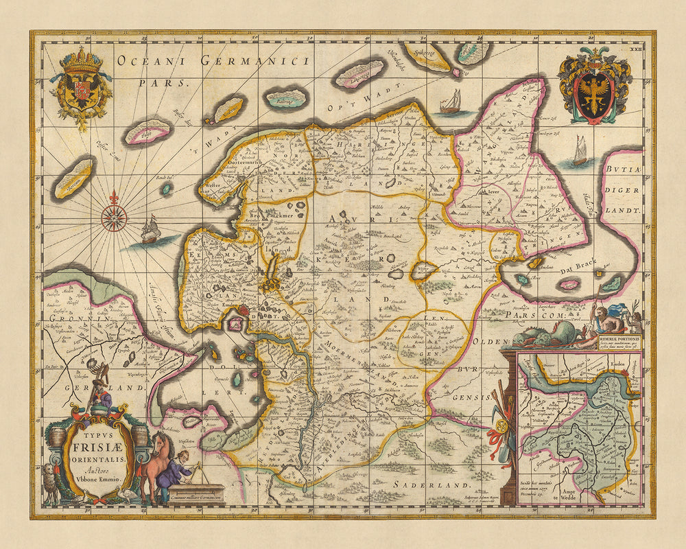
Il modello nelle immagini dell'elenco tiene la versione 16x20in (40.5x51cm) di questa mappa.
La quinta immagine dell'elenco mostra un esempio del mio servizio di personalizzazione della mappa.
Se stai cercando qualcosa di leggermente diverso, dai un'occhiata alla mia collezione delle migliori vecchie mappe d'Europa e delle città europee per vedere se qualcosa attira la tua attenzione.
Per favore contattami per verificare se una certa posizione, punto di riferimento o caratteristica è mostrata su questa mappa.
Questo sarebbe un meraviglioso regalo di compleanno, Natale, Festa del Papà, per un lavoro che finisce, anniversario o per una festa di inaugurazione per qualcuno delle aree coperte da questa mappa.
Questa mappa è disponibile come stampa giclée su carta opaca archiviata senza acidi, oppure puoi acquistarla incorniciata. La cornice è una bella e semplice cornice nera che si adatta alla maggior parte degli stili estetici. Ti preghiamo di contattarci se desideri un colore o un materiale diverso per la cornice. Le mie cornici sono dotate di vetro acrilico super chiaro di qualità museale (perspex/acrylite), che è significativamente meno riflettente del vetro, più sicuro e arriverà sempre in perfette condizioni.
This map is also available as a float framed canvas, sometimes known as a shadow gap framed canvas or canvas floater. The map is printed on artist's cotton canvas and then stretched over a handmade box frame. We then "float" the canvas inside a wooden frame, which is available in a range of colours (black, dark brown, oak, antique gold and white). This is a wonderful way to present a map without glazing in front. See some examples of float framed canvas maps and explore the differences between my different finishes.
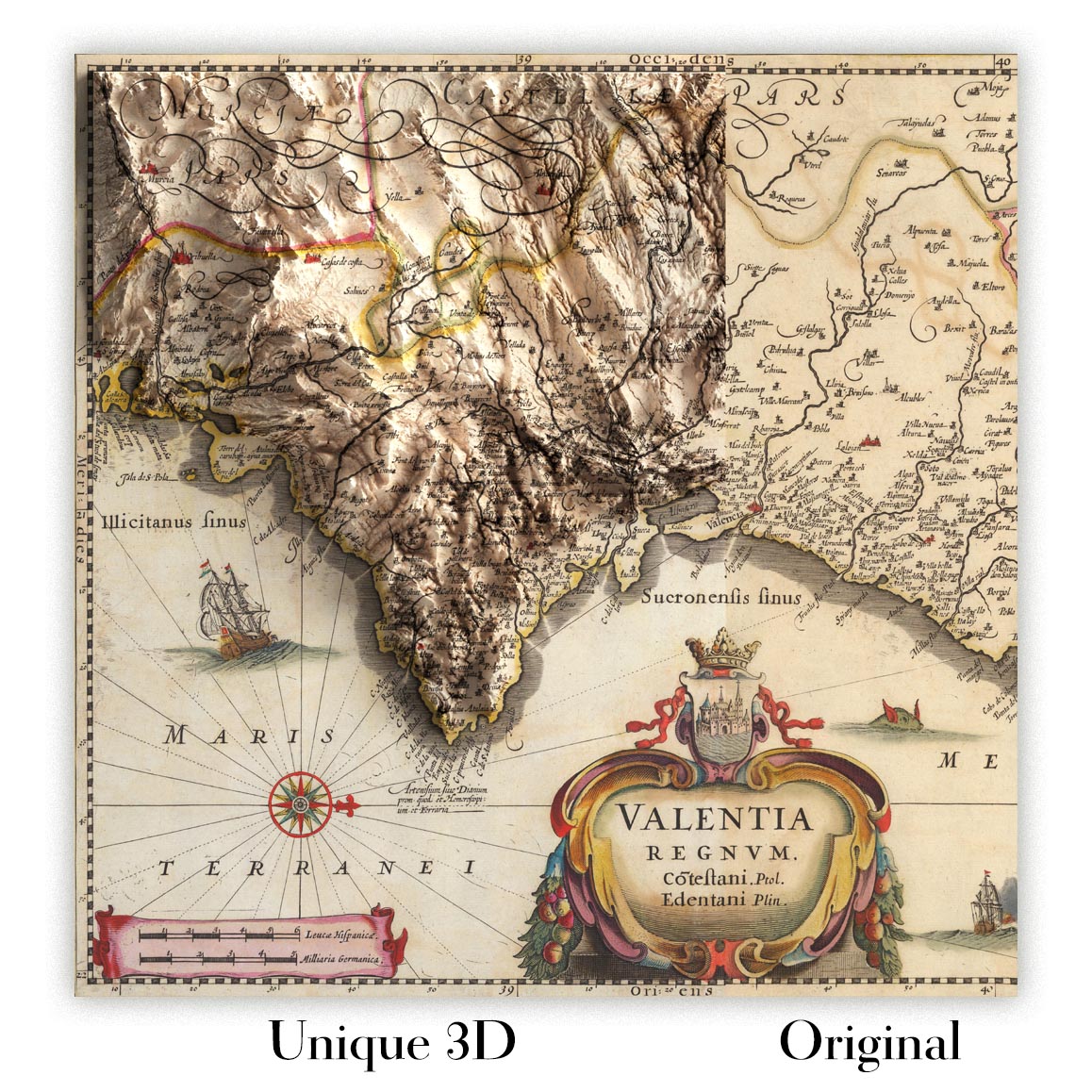
For something truly unique, this map is also available in "Unique 3D", our trademarked process that dramatically transforms the map so that it has a wonderful sense of depth. We combine the original map with detailed topography and elevation data, so that mountains and the terrain really "pop". For more info and examples of 3D maps, check my Unique 3D page.
For most orders, delivery time is about 3 working days. Personalised and customised products take longer, as I have to do the personalisation and send it to you for approval, which usually takes 1 or 2 days.
Please note that very large framed orders usually take longer to make and deliver.
If you need your order to arrive by a certain date, please contact me before you order so that we can find the best way of making sure you get your order in time.
I print and frame maps and artwork in 23 countries around the world. This means your order will be made locally, which cuts down on delivery time and ensures that it won't be damaged during delivery. You'll never pay customs or import duty, and we'll put less CO2 into the air.
All of my maps and art prints are well packaged and sent in a rugged tube if unframed, or surrounded by foam if framed.
I try to send out all orders within 1 or 2 days of receiving your order, though some products (like face masks, mugs and tote bags) can take longer to make.
If you select Express Delivery at checkout your order we will prioritise your order and send it out by 1-day courier (Fedex, DHL, UPS, Parcelforce).
Next Day delivery is also available in some countries (US, UK, Singapore, UAE) but please try to order early in the day so that we can get it sent out on time.
My standard frame is a gallery style black ash hardwood frame. It is simple and quite modern looking. My standard frame is around 20mm (0.8in) wide.
I use super-clear acrylic (perspex/acrylite) for the frame glass. It's lighter and safer than glass - and it looks better, as the reflectivity is lower.
Six standard frame colours are available for free (black, dark brown, dark grey, oak, white and antique gold). Custom framing and mounting/matting is available if you're looking for something else.
Most maps, art and illustrations are also available as a framed canvas. We use matte (not shiny) cotton canvas, stretch it over a sustainably sourced box wood frame, and then 'float' the piece within a wood frame. The end result is quite beautiful, and there's no glazing to get in the way.
All frames are provided "ready to hang", with either a string or brackets on the back. Very large frames will have heavy duty hanging plates and/or a mounting baton. If you have any questions, please get in touch.
See some examples of my framed maps and framed canvas maps.
Alternatively, I can also supply old maps and artwork on canvas, foam board, cotton rag and other materials.
If you want to frame your map or artwork yourself, please read my size guide first.
Alcune delle mie vecchie mappe sono ora disponibili come tele incorniciate. Per favore contattami se desideri ordinare una dimensione che non è disponibile nel mio negozio.
Le vecchie mappe su tela sono un'alternativa interessante alle mappe incorniciate in modo convenzionale. A seconda del tuo gusto personale e dell'arredamento della stanza, le mappe su tela possono "risaltare" un po' di più rispetto a una mappa incorniciata.
My maps are extremely high quality reproductions of original maps.
I source original, rare maps from libraries, auction houses and private collections around the world, restore them at my London workshop, and then use specialist giclée inks and printers to create beautiful maps that look even better than the original.
My maps are printed on acid-free archival matte (not glossy) paper that feels very high quality and almost like card. In technical terms the paper weight/thickness is 10mil/200gsm. It's perfect for framing.
I print with Epson ultrachrome giclée UV fade resistant pigment inks - some of the best inks you can find.
I can also make maps on canvas, cotton rag and other exotic materials.
Learn more about The Unique Maps Co.
Map personalisation
If you're looking for the perfect anniversary or housewarming gift, I can personalise your map to make it truly unique. For example, I can add a short message, or highlight an important location, or add your family's coat of arms.
The options are almost infinite. Please see my map personalisation page for some wonderful examples of what's possible.
To order a personalised map, select "personalise your map" before adding it to your basket.
Get in touch if you're looking for more complex customisations and personalisations.
Map ageing
I have been asked hundreds of times over the years by customers if they could buy a map that looks even older.
Well, now you can, by selecting Aged before you add a map to your basket.
All the product photos you see on this page show the map in its Original form. This is what the map looks like today.
If you select Aged, I will age your map by hand, using a special and unique process developed through years of studying old maps, talking to researchers to understand the chemistry of aging paper, and of course... lots of practice!
If you're unsure, stick to the Original colour of the map. If you want something a bit darker and older looking, go for Aged.
Se non sei soddisfatto del tuo ordine per qualsiasi motivo, contattami per un rimborso senza problemi. Si prega di consultare la nostra politica di reso e rimborso per ulteriori informazioni.
Sono molto sicuro che ti piacerà la tua mappa restaurata o la stampa d'arte. Lo faccio dal 1984. Sono un venditore Etsy a 5 stelle. Ho venduto decine di migliaia di mappe e stampe d'arte e ho oltre 5.000 recensioni reali a 5 stelle.
Utilizzo un processo unico per restaurare mappe e opere d'arte che richiede molto tempo e lavoro. Trovare le mappe e le illustrazioni originali può richiedere mesi. Utilizzo tecnologia all'avanguardia e incredibilmente costosa per scannerizzare e restaurarle. Di conseguenza, garantisco che le mie mappe e stampe d'arte siano superiori alle altre - ecco perché posso offrire un rimborso senza problemi.
Quasi tutte le mie mappe e stampe d'arte sembrano fantastiche a grandi dimensioni (200 cm, 6,5 piedi+) e posso anche incorniciarle e consegnarle a te, tramite un corriere speciale per oggetti di grandi dimensioni. Contattami per discutere delle tue esigenze specifiche.
Or try searching for something!


