


Rara prima mappa della Repubblica Ucraina, 1919: Conferenza di Pace di Parigi, UPR, Crimea, Kuban
Compra 2, Ricevi 1 Gratuito
Se aggiungi 2 articoli al tuo carrello, puoi aggiungere un terzo prodotto gratuitamente.
Questo vale per tutte le mappe e opere d'arte, comprese le opere personalizzate e su misura. Puoi ordinare 3 dello stesso articolo, o 3 articoli diversi.
Questo equivale a uno sconto del 33%, che sarà il maggiore sconto disponibile nel mio negozio quest'anno.
Ti prego di approfittare dell'offerta e di coprire le tue pareti con bellissime mappe e opere d'arte!
Contattami se hai domande.
-
![]() Handmade locally in the EU
Handmade locally in the EU

-
FREE worldwide delivery in 2-3 days ⓘ
Free delivery in 2-3 days
Your map should be delivered in 2-3 working days with free delivery, worldwide.
We make maps by hand locally in 23 countries, including the EU
![]() . If you're buying a gift for someone in another country, we will make the map locally to them.
. If you're buying a gift for someone in another country, we will make the map locally to them.You will never pay import tax or customs duty.
Express delivery is available at checkout which can reduce the delivery time to 1-2 days.
Please note that personalised maps, and larger framed maps, can take longer to produce and deliver.
If you need your order to arrive by a certain date, contact me and we can discuss your options.
-
Complimentary gifting & design advice
ⓘ
Complimentary gifting & design advice
Available almost 24/7 on WhatsApp and email — we usually reply within minutes. We can help you:
- Choose a perfectly personalised gift
- Send a digital gift preview to the recipient
- Pick the ideal size for your wall
- Select the right finish and frame
Quick, friendly advice so you can order with confidence.
For last minute gifts, consider buying a digital gift card. We have over 5,000 maps and art prints to choose from.
-
90-day returns & 5-year guarantee
ⓘ
90 giorni per restituire e ricevere un rimborso
I prodotti possono essere restituiti entro 90 giorni per un rimborso completo, o cambio con un altro prodotto.
Per articoli personalizzati e su misura, potremmo offrirti un credito in negozio o una carta regalo non scadente, poiché non possiamo rivendere ordini personalizzati.
Se hai domande, contattaci. Per ulteriori informazioni, consulta la nostra politica di restituzione e cambio.

This is a museum-grade archival print from the original 1919 map — restored in our workshop and made to order on 220gsm archival matte paper or 400gsm artist's cotton canvas with pigment inks.
Professional framing & free personalisation available
1. Select your size
Click here to order a custom size.
2. Frame & personalise your map
Make your map unique with framing, hand-drawn customisation, vintage ageing, pop art text, unique 3D styling and more.


Gift message & custom finish

If you want to add a gift message, or a finish (jigsaw, aluminium board, etc.) that is not available here, please request it in the "order note" when you check out.
Every order is custom made, so if you need the size adjusted slightly, or printed on an unusual material, just let us know. We've done thousands of custom orders over the years, so there's (almost) nothing we can't manage.
You can also contact us before you order, if you prefer!

- Handmade locally. No import duty or tax
- FREE worldwide delivery
- 90-day returns & 5-year product guarantee
- Questions? WhatsApp me any time
Own a piece of history
7,000+ 5 star reviews


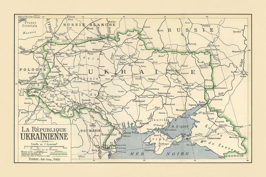
Entra nel mondo della geopolitica del primo XX secolo con la "Mappa dell'Ucraina presentata dalla delegazione ucraina alla Conferenza di Pace di Parigi, 1919." Realizzata durante un momento cruciale della storia europea, questa mappa è stata creata dalla Repubblica Popolare Ucraina, uno stato nascenti che cercava riconoscimento e stabilità nel tumulto successivo alla Prima Guerra Mondiale. Mentre i rappresentanti dell'Ucraina presentavano le loro rivendicazioni territoriali alla Conferenza di Pace di Parigi, questa mappa serviva non solo come strumento di diplomazia ma anche come dichiarazione di identità nazionale. Delinea meticolosamente i confini che la delegazione ucraina immaginava, catturando le aspirazioni di un popolo che desiderava l'autodeterminazione.
La mappa è un tesoro di intuizioni geografiche e politiche, dettagliando una serie di caratteristiche naturali e artificiali in Ucraina e nelle regioni vicine. Fiumi notevoli come il Dnipro, il Danubio e il Don sono elegantemente segnati, accanto a catene montuose significative come i Carpazi. La delineazione della Penisola di Crimea e delle coste del Mar Nero e del Mare di Azov aggiunge alla copertura completa della mappa. Questa dettagliata mappa politica non solo evidenzia il paesaggio dell'Ucraina ma anche i confini con i paesi adiacenti, tra cui Polonia, Russia e Romania, riflettendo il complesso arazzo dei confini nazionali nell'Europa orientale del dopoguerra.
Oltre alle sue caratteristiche geografiche, la mappa è un vivace ritratto dei centri urbani che sono centrali per il tessuto culturale ed economico dell'Ucraina. Città come Kyiv, Odesa e Lviv sono evidenziate, fornendo un'istantanea del paesaggio urbano durante un periodo trasformativo nella storia della regione. L'inclusione di ciascuna città sottolinea la sua importanza, da importanti centri industriali a luoghi di patrimonio culturale, offrendo uno sguardo sul carattere diversificato dell'Ucraina.
Storicamente, la mappa rappresenta un significativo reperto della Conferenza di Pace di Parigi, un evento che ha rimodellato i confini nazionali e forgiato nuove relazioni internazionali nel periodo successivo alla Grande Guerra. La Repubblica Popolare Ucraina, sebbene di breve durata, utilizzò questa mappa come simbolo delle proprie rivendicazioni nazionali, sostenendo un posto tra la comunità delle nazioni. Offre a storici e appassionati una prospettiva unica sugli sforzi diplomatici di una nazione-stato in erba e sui più ampi cambiamenti geopolitici del primo XX secolo.
Per i collezionisti e gli appassionati di mappe storiche, questo pezzo non è solo una mappa ma una narrazione intessuta nel tessuto della storia europea. Serve come testimonianza della lotta duratura per la sovranità e della danza intricata della diplomazia che definisce il nostro mondo. Possedere questa mappa è come possedere un frammento di storia, una finestra nell'anima di una nazione e nel periodo turbolento che ha plasmato il suo destino.
Città e paesi su questa mappa
- Kyiv (3,7 milioni)
- Kharkiv (1,4 milioni)
- Odesa (1 milione)
- Donetsk (900 mila)
- Dnipro (900 mila)
- Zaporizhzhia (750 mila)
- Lviv (720 mila)
- Kryvyi Rih (650 mila)
- Mykolaiv (490 mila)
- Mariupol (450 mila)
- Luhansk (420 mila)
- Vinnytsia (370 mila)
- Poltava (320 mila)
- Chernihiv (290 mila)
- Kherson (290 mila)
- Cherkasy (280 mila)
- Rivne (250 mila)
- Zhytomyr (250 mila)
- Kamianets-Podilskyi (100 mila)
- Uzhhorod (100 mila)
- Mukachevo (85 mila)
- Ivano-Frankivsk (85 mila)
- Ternopil (85 mila)
- Drohobych (75 mila)
- Kolomyia (65 mila)
- Chernivtsi (65 mila)
- Bila Tserkva (65 mila)
- Berdychiv (65 mila)
- Pavlohrad (65 mila)
- Alchevsk (60 mila)
- Kramatorsk (60 mila)
- Lysychansk (60 mila)
- Sievierodonetsk (60 mila)
- Rubizhne (60 mila)
- Pervomaisk (60 mila)
- Horlivka (55 mila)
- Kadiivka (55 mila)
- Yenakiieve (55 mila)
- Makiivka (55 mila)
- Shakhtarsk (55 mila)
- Torez (55 mila)
- Snizhne (55 mila)
- Antratsyt (55 mila)
- Rovenky (50 mila)
- Krasnyi Luch (50 mila)
- Stakhanov (50 mila)
- Alushta (50 mila)
- Feodosiya (50 mila)
- Kerch (50 mila)
- Yevpatoriia (50 mila)
- Bakhchysarai (50 mila)
- Dzhankoi (50 mila)
- Sudak (50 mila)
- Novomoskovsk (50 mila)
- Zmiiv (50 mila)
- Lozova (50 mila)
- Izium (50 mila)
- Kupiansk (50 mila)
- Balakliia (50 mila)
- Krasnohrad (50 mila)
- Zolochiv (50 mila)
- Brody (50 mila)
- Dolyna (50 mila)
- Kalush (50 mila)
- Sambir (50 mila)
- Drohobych (50 mila)
- Stryi (50 mila)
- Mukachevo (50 mila)
- Berehove (50 mila)
- Vynohradiv (50 mila)
- Tiachiv (50 mila)
- Rakhiv (50 mila)
- Kovel (50 mila)
- Novovolynsk (50 mila)
- Volodymyr (50 mila)
- Lokachi (50 mila)
- Kamin-Kashyrskyi (50 mila)
- Sarny (50 mila)
- Dubno (50 mila)
- Kremenets (50 mila)
- Zbarazh (50 mila)
- Ternopil (50 mila)
- Chortkiv (50 mila)
- Buchach (50 mila)
- Monastyryska (50 mila)
- Borshchiv (50 mila)
- Zalishchyky (50 mila)
- Horodenka (50 mila)
- Kolomyia (50 mila)
- Snyatyn (50 mila)
- Nadvirna (50 mila)
- Yaremche (50 mila)
- Dolyna (50 mila)
- Bolekhiv (50 mila)
- Tysmenytsia (50 mila)
- Rohatyn (50 mila)
- Berezhany (50 mila)
- Pidhaitsi (50 mila)
Caratteristiche e monumenti notevoli
- Confini della Repubblica Popolare Ucraina
- Fiume Dnipro
- Mare Nero
- Mare d'Azov
- Monti Carpazi
- Penisola di Crimea
- Fiume Danubio
- Fiume Desna
- Fiume Don
- Fiume Dniester
- Paludi di Pripet
- Fiume San
- Fiume Bug Meridionale
- Fiume Vistola
- Fiume Volga
Contesto storico e di design
- Titolo: Mappa dell'Ucraina presentata dalla delegazione ucraina alla Conferenza di Pace di Parigi, 1919
- Creata dalla Repubblica Popolare Ucraina durante la Conferenza di Pace di Parigi nel 1919-20.
- Mostra i confini dell'Ucraina come dichiarato dalla delegazione della Repubblica Popolare Ucraina.
- Mappa politica dettagliata che evidenzia le principali città, paesi e caratteristiche geografiche.
- Riflette il contesto storico dell'Europa orientale post Prima Guerra Mondiale e le aspirazioni della Repubblica Popolare Ucraina.
- Risorsa preziosa per comprendere la storia dell'Ucraina e della regione.
Si prega di controllare attentamente le immagini per assicurarsi che una specifica città o luogo sia mostrato su questa mappa. Puoi anche contattarci e chiedere di controllare la mappa per te.
Questa mappa appare fantastica in ogni dimensione, ma consiglio sempre di optare per una dimensione più grande se hai spazio. In questo modo puoi facilmente distinguere tutti i dettagli.
Questa mappa sembra incredibile in dimensioni fino a 40 pollici (100 cm). Se stai cercando una mappa più grande, per favore contattaci.
Il modello nelle immagini dell'annuncio tiene la versione 24x36 pollici (60x90 cm) di questa mappa.
La quinta immagine dell'annuncio mostra un esempio del mio servizio di personalizzazione della mappa.
Se stai cercando qualcosa di leggermente diverso, dai un'occhiata alla mia collezione delle migliori mappe antiche per vedere se qualcosa attira la tua attenzione.
Per favore contattami per verificare se una certa località, punto di riferimento o caratteristica è mostrata su questa mappa.
Questo sarebbe un meraviglioso regalo di compleanno, Natale, Festa del Papà, partenza dal lavoro, anniversario o di inaugurazione per qualcuno delle aree coperte da questa mappa.
Questa mappa è disponibile come stampa giclée su carta opaca archiviata senza acidi, oppure puoi acquistarla incorniciata. La cornice è una semplice cornice nera che si adatta alla maggior parte degli stili. Per favore contattaci se desideri un colore o un materiale diverso per la cornice. Le mie cornici sono rivestite con acrilico (perspex/acrylite) di grado museale super chiaro, che è significativamente meno riflettente del vetro, più sicuro e arriverà sempre in perfette condizioni.
This map is also available as a float framed canvas, sometimes known as a shadow gap framed canvas or canvas floater. The map is printed on artist's cotton canvas and then stretched over a handmade box frame. We then "float" the canvas inside a wooden frame, which is available in a range of colours (black, dark brown, oak, antique gold and white). This is a wonderful way to present a map without glazing in front. See some examples of float framed canvas maps and explore the differences between my different finishes.
For something truly unique, this map is also available in "Unique 3D", our trademarked process that dramatically transforms the map so that it has a wonderful sense of depth. We combine the original map with detailed topography and elevation data, so that mountains and the terrain really "pop". For more info and examples of 3D maps, check my Unique 3D page.
For most orders, delivery time is about 3 working days. Personalised and customised products take longer, as I have to do the personalisation and send it to you for approval, which usually takes 1 or 2 days.
Please note that very large framed orders usually take longer to make and deliver.
If you need your order to arrive by a certain date, please contact me before you order so that we can find the best way of making sure you get your order in time.
I print and frame maps and artwork in 23 countries around the world. This means your order will be made locally, which cuts down on delivery time and ensures that it won't be damaged during delivery. You'll never pay customs or import duty, and we'll put less CO2 into the air.
All of my maps and art prints are well packaged and sent in a rugged tube if unframed, or surrounded by foam if framed.
I try to send out all orders within 1 or 2 days of receiving your order, though some products (like face masks, mugs and tote bags) can take longer to make.
If you select Express Delivery at checkout your order we will prioritise your order and send it out by 1-day courier (Fedex, DHL, UPS, Parcelforce).
Next Day delivery is also available in some countries (US, UK, Singapore, UAE) but please try to order early in the day so that we can get it sent out on time.
My standard frame is a gallery style black ash hardwood frame. It is simple and quite modern looking. My standard frame is around 20mm (0.8in) wide.
I use super-clear acrylic (perspex/acrylite) for the frame glass. It's lighter and safer than glass - and it looks better, as the reflectivity is lower.
Six standard frame colours are available for free (black, dark brown, dark grey, oak, white and antique gold). Custom framing and mounting/matting is available if you're looking for something else.
Most maps, art and illustrations are also available as a framed canvas. We use matte (not shiny) cotton canvas, stretch it over a sustainably sourced box wood frame, and then 'float' the piece within a wood frame. The end result is quite beautiful, and there's no glazing to get in the way.
All frames are provided "ready to hang", with either a string or brackets on the back. Very large frames will have heavy duty hanging plates and/or a mounting baton. If you have any questions, please get in touch.
See some examples of my framed maps and framed canvas maps.
Alternatively, I can also supply old maps and artwork on canvas, foam board, cotton rag and other materials.
If you want to frame your map or artwork yourself, please read my size guide first.
Alcune delle mie vecchie mappe sono ora disponibili come tele incorniciate. Per favore contattami se desideri ordinare una dimensione che non è disponibile nel mio negozio.
Le vecchie mappe su tela sono un'alternativa interessante alle mappe incorniciate in modo convenzionale. A seconda del tuo gusto personale e dell'arredamento della stanza, le mappe su tela possono "risaltare" un po' di più rispetto a una mappa incorniciata.
My maps are extremely high quality reproductions of original maps.
I source original, rare maps from libraries, auction houses and private collections around the world, restore them at my London workshop, and then use specialist giclée inks and printers to create beautiful maps that look even better than the original.
My maps are printed on acid-free archival matte (not glossy) paper that feels very high quality and almost like card. In technical terms the paper weight/thickness is 10mil/200gsm. It's perfect for framing.
I print with Epson ultrachrome giclée UV fade resistant pigment inks - some of the best inks you can find.
I can also make maps on canvas, cotton rag and other exotic materials.
Learn more about The Unique Maps Co.
Map personalisation
If you're looking for the perfect anniversary or housewarming gift, I can personalise your map to make it truly unique. For example, I can add a short message, or highlight an important location, or add your family's coat of arms.
The options are almost infinite. Please see my map personalisation page for some wonderful examples of what's possible.
To order a personalised map, select "personalise your map" before adding it to your basket.
Get in touch if you're looking for more complex customisations and personalisations.
Map ageing
I have been asked hundreds of times over the years by customers if they could buy a map that looks even older.
Well, now you can, by selecting Aged before you add a map to your basket.
All the product photos you see on this page show the map in its Original form. This is what the map looks like today.
If you select Aged, I will age your map by hand, using a special and unique process developed through years of studying old maps, talking to researchers to understand the chemistry of aging paper, and of course... lots of practice!
If you're unsure, stick to the Original colour of the map. If you want something a bit darker and older looking, go for Aged.
Se non sei soddisfatto del tuo ordine per qualsiasi motivo, contattami per un rimborso senza problemi. Si prega di consultare la nostra politica di reso e rimborso per ulteriori informazioni.
Sono molto sicuro che ti piacerà la tua mappa restaurata o la stampa d'arte. Lo faccio dal 1984. Sono un venditore Etsy a 5 stelle. Ho venduto decine di migliaia di mappe e stampe d'arte e ho oltre 5.000 recensioni reali a 5 stelle.
Utilizzo un processo unico per restaurare mappe e opere d'arte che richiede molto tempo e lavoro. Trovare le mappe e le illustrazioni originali può richiedere mesi. Utilizzo tecnologia all'avanguardia e incredibilmente costosa per scannerizzare e restaurarle. Di conseguenza, garantisco che le mie mappe e stampe d'arte siano superiori alle altre - ecco perché posso offrire un rimborso senza problemi.
Quasi tutte le mie mappe e stampe d'arte sembrano fantastiche a grandi dimensioni (200 cm, 6,5 piedi+) e posso anche incorniciarle e consegnarle a te, tramite un corriere speciale per oggetti di grandi dimensioni. Contattami per discutere delle tue esigenze specifiche.
Or try searching for something!


