


Ancienne carte du football universitaire américain par Sundberg, 1942: Équipes majeures, conférences, époque de la Seconde Guerre mondiale
L’offre du collectionneur
Choisissez deux œuvres éligibles et bénéficiez de 20 % de réduction sur les deux. Choisissez-en trois et celle au prix le plus bas est offerte, pour une économie maximale de 33 %.
Associez librement des cartes standard éligibles et des tirages d’art. Aucun code n’est requis ; l’offre est appliquée automatiquement lors du paiement.
Les configurations standard réalisées sur commande sont incluses. Les formats sur mesure, les créations personnalisées et les œuvres commissionnées sont exclus.
Besoin d’une livraison à différentes adresses ? Contactez-nous avant de commander.L’offre du collectionneur
Choisissez deux œuvres éligibles et bénéficiez de 20 % de réduction sur les deux. Choisissez-en trois et celle au prix le plus bas est offerte, pour une économie maximale de 33 %.
Associez librement des cartes standard éligibles et des tirages d’art. Aucun code n’est requis ; l’offre est appliquée automatiquement lors du paiement.
Les configurations standard réalisées sur commande sont incluses. Les formats sur mesure, les créations personnalisées et les œuvres commissionnées sont exclus.
Besoin d’une livraison à différentes adresses ? Contactez-nous avant de commander. Conçu à Londres Fabriqué dans l’UE
Conçu à Londres • Fabriqué dans l’UE
Conçu à Londres Fabriqué dans l’UE
Conçu à Londres • Fabriqué dans l’UE

Restaurée à partir de la carte originale de 1942 et imprimée en qualité musée. Lire l’histoire de cette carte
Choose your size
Choose your finish


(Plus d’infos)
Message cadeau & finition personnalisée

Si vous souhaitez ajouter un message cadeau, ou une finition (puzzle, panneau en aluminium, etc.) qui n'est pas disponible ici, veuillez le demander dans la "note de commande" lors de votre passage à la caisse.
Chaque commande est fabriquée sur mesure, donc si vous avez besoin d'ajuster légèrement la taille, ou d'imprimer sur un matériau inhabituel, faites-le nous savoir. Nous avons réalisé des milliers de commandes personnalisées au fil des ans, donc il n'y a (presque) rien que nous ne puissions gérer.
Vous pouvez également nous contacter avant de passer votre commande, si vous le souhaitez !

- Fabriqué localement. Livraison sûre
- Sans droits ni frais cachés
- Besoin d’aide ? Appelez-nous ou message WhatsApp
Own a piece of history
8,000+ five-star reviews


Pénétrez dans le monde dynamique du sport américain du milieu du siècle avec "U.S.A. Gridiron", une carte picturale exubérante créée par Edwin...
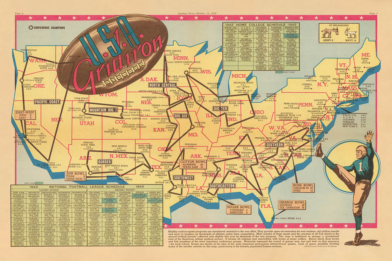
Continuer la lecturePénétrez dans le monde dynamique du sport américain du milieu du siècle avec "U.S.A. Gridiron", une carte picturale exubérante créée par Edwin L. Sundberg en 1942. Commandée par le Sunday News de New York, cette carte offre un tableau vibrant de la nation à un moment charnière de l'histoire. Avec son design en pleine couleur au centre, "U.S.A. Gridiron" capture l'esprit du football universitaire pendant la Seconde Guerre mondiale, présentant une « vue de gradins du tableau du football universitaire américain. » Le réseau complexe de lignes noires de la carte relie les principales équipes de football universitaire du pays, tandis que des cases numérotées documentent méticuleusement leurs records, invitant les spectateurs à retracer les rivalités et les triomphes qui ont défini la saison 1942.
Edwin L. Sundberg, un artiste cartographe distingué pour le Sunday News, était renommé pour sa capacité à distiller des sujets complexes en récits visuellement captivants. Son travail sur "U.S.A. Gridiron" illustre ce don, mêlant la précision de la cartographie à l'exubérance de la culture sportive américaine. Le flair artistique de Sundberg brille à travers les illustrations ludiques de la carte—des joueurs de football en action, des poteaux de but et des casques—transformant la carte en une célébration de l'athlétisme et de la camaraderie. Ce n'est pas seulement un document géographique ; c'est une chronique vivante de la résilience et de l'unité américaines durant une période de bouleversements mondiaux.
Géographiquement, la carte englobe l'ensemble des États-Unis, délimitant élégamment les frontières des États et présentant les plus célèbres monuments naturels du pays. Le puissant fleuve Mississippi serpente à travers le cœur du pays, tandis que les Grands Lacs scintillent au nord. Des chaînes de montagnes stylisées, des Rocheuses aux Appalaches, s'élèvent à travers le paysage, et les océans Atlantique et Pacifique encadrent l'étendue de la nation. Des insets pour l'Alaska et Hawaï, alors territoires, soulignent l'ampleur du paysage sportif américain, tandis qu'une rose des vents décorative et une bordure thématique ajoutent une touche de charme d'époque.
La tapisserie urbaine de la carte est aussi impressionnante que ses caractéristiques naturelles. Elle met en avant des villes majeures telles que New York, Los Angeles, Chicago et Houston—des métropoles qui restent des puissances aujourd'hui—aux côtés de villes universitaires légendaires comme Ann Arbor, Norman et West Point. Chaque établissement n'est pas simplement un point sur la carte mais un témoignage de l'héritage durable de l'athlétisme collégial dans la formation de l'identité américaine. L'annotation soignée de la carte des conférences de football et des records de jeux offre une fenêtre fascinante sur les rivalités sportives de l'époque, tandis que ses tableaux pour la National Football League 1942 et les horaires des collèges à domicile fournissent un rare aperçu du tissu organisationnel du football en temps de guerre.
Historiquement, "U.S.A. Gridiron" se dresse comme un artefact unique de la culture américaine, mêlant l'excitation du sport à l'art de la cartographie. Publiée durant l'incertitude de la Seconde Guerre mondiale, elle reflète le désir de continuité, de divertissement et de fierté de la nation. La création de Sundberg est à la fois une célébration de l'âge d'or du football et un rappel poignant du pouvoir du sport à unir des communautés à travers de vastes distances. Pour les collectionneurs et les amateurs d'Americana, cette carte est un instantané évocateur d'une nation en mouvement—tant sur le terrain que dans le paysage.
Villes et villages sur cette carte
- New York City, NY
- Los Angeles, CA
- Chicago, IL
- Houston, TX
- Philadelphie, PA
- Dallas, TX
- San Francisco, CA
- Boston, MA
- Washington, D.C.
- Atlanta, GA
- Miami, FL
- Détroit, MI
- Seattle, WA
- Denver, CO
- Minneapolis, MN
- St. Louis, MO
- Pittsburgh, PA
- Cleveland, OH
- Cincinnati, OH
- Kansas City, MO
- Baltimore, MD
- Nouvelle-Orléans, LA
- Buffalo, NY
- Oklahoma City, OK
- Louisville, KY
- Portland, OR
- Columbus, OH
- Indianapolis, IN
- Milwaukee, WI
- Charlotte, NC
- Nashville, TN
- Salt Lake City, UT
- Raleigh, NC
- Richmond, VA
- Des Moines, IA
- Omaha, NE
- Birmingham, AL
- Providence, RI
- Tulsa, OK
- Lincoln, NE
- Madison, WI
- Lansing, MI
- Baton Rouge, LA
- Columbia, SC
- Fayetteville, AR
- Ames, IA
- Eugene, OR
- Stillwater, OK
- Laramie, WY
- Manhattan, KS
- Norman, OK
- West Point, NY (Académie militaire des États-Unis)
- Annapolis, MD (Académie navale des États-Unis)
Caractéristiques et monuments notables
- Illustrations de joueurs de football en poses d'action dispersées sur la carte
- Lignes noires reliant les écoles au sein de la même conférence de football
- Cases numérotées indiquant les bilans de victoires-défaites des équipes
- Bordure décorative présentant des motifs de football et des casques
- Tableaux détaillant le calendrier de la Ligue nationale de football de 1942 et le calendrier des collèges à domicile
- Représentations picturales de ballons de football, de poteaux de but et d'autres accessoires sportifs
- Bordures d'état stylisées pour tous les États-Unis
- Rivières majeures (par exemple, le fleuve Mississippi) et les Grands Lacs illustrés pour un contexte géographique
Contexte historique et de conception
- Créé par Edwin L. Sundberg, un artiste cartographe distingué pour le Sunday News, New York
- Publié le 11 octobre 1942, pendant la Seconde Guerre mondiale
- Offre un tableau vibrant du football universitaire américain et des institutions d'enseignement supérieur au début des années 1940
- Carte picturale en pleine couleur, pliée au centre, alliant précision cartographique et illustration ludique
- Reflète l'intersection du sport, de la géographie et du journalisme dans l'Amérique du milieu du 20e siècle
- Un artefact rare qui capture le moral national et l'unité favorisés par le football universitaire en temps de guerre
- Présente un aperçu complet du paysage du football universitaire, y compris les rivalités de conférence et les bilans de saison
Veuillez vérifier les images pour vous assurer qu'une ville ou un lieu spécifique est représenté sur cette carte. Vous pouvez également nous contacter et nous demander de vérifier la carte pour vous.
Cette carte a fière allure à toutes les tailles, mais je recommande toujours d'opter pour une taille plus grande si vous avez de l'espace. De cette façon, vous pouvez facilement distinguer tous les détails.
Cette carte est magnifique dans des tailles allant jusqu'à 90in (230cm). Si vous cherchez une carte plus grande, veuillez nous contacter.
Le modèle dans les images de la liste tient la version 24x36in (60x90cm) de cette carte.
La cinquième image de la liste montre un exemple de mon service de personnalisation de cartes.
Si vous recherchez quelque chose de légèrement différent, consultez ma collection des meilleures anciennes cartes pour voir si quelque chose d'autre attire votre attention.
Veuillez me contacter pour vérifier si un certain emplacement, monument ou caractéristique est représenté sur cette carte.
Cela ferait un merveilleux cadeau d'anniversaire, de Noël, pour la fête des pères, pour un départ au travail, un anniversaire de mariage ou une pendaison de crémaillère pour quelqu'un des régions couvertes par cette carte.
Cette carte est disponible en tant qu'impression giclée sur papier mat d'archives sans acide, ou vous pouvez l'acheter encadrée. Le cadre est un joli cadre noir simple qui convient à la plupart des esthétiques. Veuillez me contacter si vous souhaitez une couleur ou un matériau de cadre différent. Mes cadres sont vitrées avec un acrylique de musée super clair (perspex/acrylite), qui est significativement moins réfléchissant que le verre, plus sûr, et arrivera toujours en parfait état.
This map is also available as a float framed canvas, sometimes known as a shadow gap framed canvas or canvas floater. The map is printed on artist's cotton canvas and then stretched over a handmade box frame. We then "float" the canvas inside a wooden frame, which is available in a range of colours (black, dark brown, oak, antique gold and white). This is a wonderful way to present a map without glazing in front. See some examples of float framed canvas maps and explore the differences between my different finishes.
For something truly unique, this map is also available in "Unique 3D", our trademarked process that dramatically transforms the map so that it has a wonderful sense of depth. We combine the original map with detailed topography and elevation data, so that mountains and the terrain really "pop". For more info and examples of 3D maps, check my Unique 3D page.
Pénétrez dans le monde dynamique du sport américain du milieu du siècle avec "U.S.A. Gridiron", une carte picturale exubérante créée par Edwin L. Sundberg en 1942. Commandée par le Sunday News de New York, cette carte offre un tableau vibrant de la nation à un moment charnière de l'histoire. Avec son design en pleine couleur au centre, "U.S.A. Gridiron" capture l'esprit du football universitaire pendant la Seconde Guerre mondiale, présentant une « vue de gradins du tableau du football universitaire américain. » Le réseau complexe de lignes noires de la carte relie les principales équipes de football universitaire du pays, tandis que des cases numérotées documentent méticuleusement leurs records, invitant les spectateurs à retracer les rivalités et les triomphes qui ont défini la saison 1942.
Edwin L. Sundberg, un artiste cartographe distingué pour le Sunday News, était renommé pour sa capacité à distiller des sujets complexes en récits visuellement captivants. Son travail sur "U.S.A. Gridiron" illustre ce don, mêlant la précision de la cartographie à l'exubérance de la culture sportive américaine. Le flair artistique de Sundberg brille à travers les illustrations ludiques de la carte—des joueurs de football en action, des poteaux de but et des casques—transformant la carte en une célébration de l'athlétisme et de la camaraderie. Ce n'est pas seulement un document géographique ; c'est une chronique vivante de la résilience et de l'unité américaines durant une période de bouleversements mondiaux.
Géographiquement, la carte englobe l'ensemble des États-Unis, délimitant élégamment les frontières des États et présentant les plus célèbres monuments naturels du pays. Le puissant fleuve Mississippi serpente à travers le cœur du pays, tandis que les Grands Lacs scintillent au nord. Des chaînes de montagnes stylisées, des Rocheuses aux Appalaches, s'élèvent à travers le paysage, et les océans Atlantique et Pacifique encadrent l'étendue de la nation. Des insets pour l'Alaska et Hawaï, alors territoires, soulignent l'ampleur du paysage sportif américain, tandis qu'une rose des vents décorative et une bordure thématique ajoutent une touche de charme d'époque.
La tapisserie urbaine de la carte est aussi impressionnante que ses caractéristiques naturelles. Elle met en avant des villes majeures telles que New York, Los Angeles, Chicago et Houston—des métropoles qui restent des puissances aujourd'hui—aux côtés de villes universitaires légendaires comme Ann Arbor, Norman et West Point. Chaque établissement n'est pas simplement un point sur la carte mais un témoignage de l'héritage durable de l'athlétisme collégial dans la formation de l'identité américaine. L'annotation soignée de la carte des conférences de football et des records de jeux offre une fenêtre fascinante sur les rivalités sportives de l'époque, tandis que ses tableaux pour la National Football League 1942 et les horaires des collèges à domicile fournissent un rare aperçu du tissu organisationnel du football en temps de guerre.
Historiquement, "U.S.A. Gridiron" se dresse comme un artefact unique de la culture américaine, mêlant l'excitation du sport à l'art de la cartographie. Publiée durant l'incertitude de la Seconde Guerre mondiale, elle reflète le désir de continuité, de divertissement et de fierté de la nation. La création de Sundberg est à la fois une célébration de l'âge d'or du football et un rappel poignant du pouvoir du sport à unir des communautés à travers de vastes distances. Pour les collectionneurs et les amateurs d'Americana, cette carte est un instantané évocateur d'une nation en mouvement—tant sur le terrain que dans le paysage.
Villes et villages sur cette carte
- New York City, NY
- Los Angeles, CA
- Chicago, IL
- Houston, TX
- Philadelphie, PA
- Dallas, TX
- San Francisco, CA
- Boston, MA
- Washington, D.C.
- Atlanta, GA
- Miami, FL
- Détroit, MI
- Seattle, WA
- Denver, CO
- Minneapolis, MN
- St. Louis, MO
- Pittsburgh, PA
- Cleveland, OH
- Cincinnati, OH
- Kansas City, MO
- Baltimore, MD
- Nouvelle-Orléans, LA
- Buffalo, NY
- Oklahoma City, OK
- Louisville, KY
- Portland, OR
- Columbus, OH
- Indianapolis, IN
- Milwaukee, WI
- Charlotte, NC
- Nashville, TN
- Salt Lake City, UT
- Raleigh, NC
- Richmond, VA
- Des Moines, IA
- Omaha, NE
- Birmingham, AL
- Providence, RI
- Tulsa, OK
- Lincoln, NE
- Madison, WI
- Lansing, MI
- Baton Rouge, LA
- Columbia, SC
- Fayetteville, AR
- Ames, IA
- Eugene, OR
- Stillwater, OK
- Laramie, WY
- Manhattan, KS
- Norman, OK
- West Point, NY (Académie militaire des États-Unis)
- Annapolis, MD (Académie navale des États-Unis)
Caractéristiques et monuments notables
- Illustrations de joueurs de football en poses d'action dispersées sur la carte
- Lignes noires reliant les écoles au sein de la même conférence de football
- Cases numérotées indiquant les bilans de victoires-défaites des équipes
- Bordure décorative présentant des motifs de football et des casques
- Tableaux détaillant le calendrier de la Ligue nationale de football de 1942 et le calendrier des collèges à domicile
- Représentations picturales de ballons de football, de poteaux de but et d'autres accessoires sportifs
- Bordures d'état stylisées pour tous les États-Unis
- Rivières majeures (par exemple, le fleuve Mississippi) et les Grands Lacs illustrés pour un contexte géographique
Contexte historique et de conception
- Créé par Edwin L. Sundberg, un artiste cartographe distingué pour le Sunday News, New York
- Publié le 11 octobre 1942, pendant la Seconde Guerre mondiale
- Offre un tableau vibrant du football universitaire américain et des institutions d'enseignement supérieur au début des années 1940
- Carte picturale en pleine couleur, pliée au centre, alliant précision cartographique et illustration ludique
- Reflète l'intersection du sport, de la géographie et du journalisme dans l'Amérique du milieu du 20e siècle
- Un artefact rare qui capture le moral national et l'unité favorisés par le football universitaire en temps de guerre
- Présente un aperçu complet du paysage du football universitaire, y compris les rivalités de conférence et les bilans de saison
Veuillez vérifier les images pour vous assurer qu'une ville ou un lieu spécifique est représenté sur cette carte. Vous pouvez également nous contacter et nous demander de vérifier la carte pour vous.
Cette carte a fière allure à toutes les tailles, mais je recommande toujours d'opter pour une taille plus grande si vous avez de l'espace. De cette façon, vous pouvez facilement distinguer tous les détails.
Cette carte est magnifique dans des tailles allant jusqu'à 90in (230cm). Si vous cherchez une carte plus grande, veuillez nous contacter.
Le modèle dans les images de la liste tient la version 24x36in (60x90cm) de cette carte.
La cinquième image de la liste montre un exemple de mon service de personnalisation de cartes.
Si vous recherchez quelque chose de légèrement différent, consultez ma collection des meilleures anciennes cartes pour voir si quelque chose d'autre attire votre attention.
Veuillez me contacter pour vérifier si un certain emplacement, monument ou caractéristique est représenté sur cette carte.
Cela ferait un merveilleux cadeau d'anniversaire, de Noël, pour la fête des pères, pour un départ au travail, un anniversaire de mariage ou une pendaison de crémaillère pour quelqu'un des régions couvertes par cette carte.
Cette carte est disponible en tant qu'impression giclée sur papier mat d'archives sans acide, ou vous pouvez l'acheter encadrée. Le cadre est un joli cadre noir simple qui convient à la plupart des esthétiques. Veuillez me contacter si vous souhaitez une couleur ou un matériau de cadre différent. Mes cadres sont vitrées avec un acrylique de musée super clair (perspex/acrylite), qui est significativement moins réfléchissant que le verre, plus sûr, et arrivera toujours en parfait état.
This map is also available as a float framed canvas, sometimes known as a shadow gap framed canvas or canvas floater. The map is printed on artist's cotton canvas and then stretched over a handmade box frame. We then "float" the canvas inside a wooden frame, which is available in a range of colours (black, dark brown, oak, antique gold and white). This is a wonderful way to present a map without glazing in front. See some examples of float framed canvas maps and explore the differences between my different finishes.
For something truly unique, this map is also available in "Unique 3D", our trademarked process that dramatically transforms the map so that it has a wonderful sense of depth. We combine the original map with detailed topography and elevation data, so that mountains and the terrain really "pop". For more info and examples of 3D maps, check my Unique 3D page.
Many of our maps and art prints are chosen as thoughtful gifts for homes, offices, studies and meaningful places.
Choose a framed option for the easiest ready-to-hang gift, or choose an unframed print if the recipient may prefer to select their own frame.
We make orders locally in 23 countries around the world, so gifts can often be produced close to the recipient. This helps them arrive faster, travel more safely, and avoid customs or import duty surprises.
- We can deliver directly to the recipient
- Framed pieces arrive ready to hang
- Unframed prints are carefully packed in a strong protective tube
- Almost every order is made locally, for faster, safer gifting
- 90-day returns give the recipient time to decide
If you are not sure what to choose, please contact us. We can help you pick the right map, size, finish or delivery option.
Pour la plupart des commandes, le délai de livraison est d'environ 3 jours ouvrables. Les produits personnalisés et sur mesure prennent plus de temps, car je dois faire la personnalisation et vous l'envoyer pour approbation, ce qui prend généralement 1 ou 2 jours.
Veuillez noter que les grandes commandes encadrées prennent généralement plus de temps à réaliser et à livrer.
Si vous avez besoin que votre commande arrive à une date précise, veuillez me contacter avant de passer votre commande afin que nous puissions trouver le meilleur moyen de nous assurer que vous receviez votre commande à temps.
J'imprime et encadre des cartes et des œuvres d'art dans 23 pays à travers le monde. Cela signifie que votre commande sera réalisée localement, ce qui réduit le temps de livraison et garantit qu'elle ne sera pas endommagée pendant le transport. Vous ne paierez jamais de droits de douane ou d'importation, et nous mettrons moins de CO2 dans l'air.
Toutes mes cartes et impressions artistiques sont bien emballées et envoyées dans un tube robuste si non encadrées, ou entourées de mousse si encadrées.
J'essaie d'envoyer toutes les commandes dans les 1 ou 2 jours suivant la réception de votre commande, bien que certains produits (comme les masques, les mugs et les sacs fourre-tout) puissent prendre plus de temps à réaliser.
Si vous choisissez Livraison Express lors du paiement, nous donnerons la priorité à votre commande et l'enverrons par un service de messagerie de 1 jour (Fedex, DHL, UPS, Parcelforce).
La livraison le lendemain est également disponible dans certains pays (États-Unis, Royaume-Uni, Singapour, Émirats Arabes Unis), mais veuillez essayer de commander tôt dans la journée afin que nous puissions l'envoyer à temps.
Lisez mon guide complet sur la livraison et la production locale
Mon cadre standard est un cadre en bois dur noir de style galerie. Il est simple et a un aspect assez moderne. Mon cadre standard mesure environ 20 mm (0,8 po) de large.
J'utilise de l'acrylique super clair (perspex/acrylite) pour le verre du cadre. C'est plus léger et plus sûr que le verre - et cela a meilleur aspect, car la réflexivité est plus faible.
Six couleurs de cadre standard sont disponibles gratuitement (noir, marron foncé, gris foncé, chêne, blanc et or antique). Des encadrements et montages/matelassages personnalisés sont disponibles si vous recherchez autre chose.
La plupart des cartes, œuvres d'art et illustrations sont également disponibles sous forme de toile encadrée. Nous utilisons une toile en coton mate (non brillante), que nous tendons sur un cadre en bois de boîte provenant de sources durables, puis nous 'flottions' la pièce à l'intérieur d'un cadre en bois. Le résultat final est assez beau, et il n'y a pas de vitrage qui gêne.
Tous les cadres sont fournis "prêts à accrocher", avec soit une corde, soit des supports à l'arrière. Les très grands cadres auront des plaques de suspension lourdes et/ou une latte de montage. Si vous avez des questions, veuillez nous contacter.
Voir quelques exemples de mes cartes encadrées et de cartes en toile encadrées.
Alternativement, je peux également fournir de vieilles cartes et œuvres d'art sur toile, sur panneau en mousse, en coton et d'autres matériaux.
Si vous souhaitez encadrer votre carte ou œuvre d'art vous-même, veuillez lire d'abord mon guide des tailles.
Mes cartes sont des reproductions de cartes originales de très haute qualité.
Je recherche des cartes originales et rares auprès de bibliothèques, de maisons de ventes aux enchères et de collections privées du monde entier, je les restaure dans mon atelier de Londres, puis j'utilise des encres et des imprimantes giclées spécialisées pour créer de magnifiques cartes encore plus belles que l'originale.
Mes cartes sont imprimées sur du papier d’archives mat (non brillant) sans acide qui semble de très haute qualité et ressemble presque à une carte. En termes techniques, le grammage/épaisseur du papier est de 10 mil/200 g/m². C'est parfait pour l'encadrement.
J’imprime avec des encres pigmentaires Epson ultrachrome giclée UV résistantes à la décoloration – certaines des meilleures encres que vous puissiez trouver.
je peux aussi faire cartes sur toile, chiffon en coton et autres matériaux exotiques.
En savoir plus sur Unique Maps Co..
Personnalisation de la carte
Si vous recherchez le cadeau parfait pour un anniversaire ou une pendaison de crémaillère, je peux personnaliser votre carte pour la rendre vraiment unique. Par exemple, je peux ajouter un court message, mettre en évidence un lieu important ou ajouter les armoiries de votre famille.
Les options sont presque infinies. S'il vous plaît voir mon page de personnalisation de la carte pour quelques merveilleux exemples de ce qui est possible.
Pour commander une carte personnalisée, sélectionnez « personnaliser votre carte » avant de l'ajouter à votre panier.
Entrer en contact si vous recherchez des personnalisations et des personnalisations plus complexes.
Vieillissement de la carte
Au fil des ans, des clients m'ont demandé des centaines de fois s'ils pouvaient acheter une carte qui semble uniforme. plus vieux.
Eh bien, vous pouvez désormais le faire en sélectionnant Aged avant d'ajouter une carte à votre panier.
Toutes les photos de produits que vous voyez sur cette page montrent la carte dans sa forme originale. Voilà à quoi ressemble la carte aujourd'hui.
Si vous sélectionnez Vieilli, je vieillirai votre carte à la main, en utilisant un processus spécial et unique développé au cours d'années d'étude de cartes anciennes, de discussions avec des chercheurs pour comprendre la chimie du vieillissement du papier, et bien sûr... beaucoup de pratique !
Si vous n'êtes pas sûr, respectez la couleur originale de la carte. Si vous voulez quelque chose d'un peu plus sombre et plus vieux à la recherche, optez pour Aged.
Si vous n'êtes pas satisfait de votre commande pour une raison quelconque, contactez-moi pour un remboursement sans conditions. Veuillez consulter notre politique de retours et de remboursements pour plus d'informations.
Je suis très confiant que vous aimerez votre carte restaurée ou votre impression artistique. Je fais cela depuis 1984. Je suis un vendeur Etsy 5 étoiles. J'ai vendu des dizaines de milliers de cartes et d'impressions artistiques et j'ai plus de 5 000 vrais avis 5 étoiles.
J'utilise un processus unique pour restaurer des cartes et des œuvres d'art qui est extrêmement chronophage et exigeant en main-d'œuvre. Trouver les cartes et illustrations originales peut prendre des mois. J'utilise une technologie de pointe et incroyablement coûteuse pour les numériser et les restaurer. En conséquence, je garantis que mes cartes et impressions artistiques sont d'une qualité supérieure - c'est pourquoi je peux offrir un remboursement sans conditions.
Presque toutes mes cartes et impressions artistiques ont l'air incroyables en grandes tailles (200 cm, 6,5 pieds+) et je peux également les encadrer et vous les livrer, via un transporteur spécial surdimensionné. Contactez-moi pour discuter de vos besoins spécifiques.
Or try searching for something!


