


Ancienne carte nautique du détroit de Magellan par Dudley, 1646: Terre de Feu, détroit de Le Maire, Terra Australis
L’offre du collectionneur
Choisissez deux œuvres éligibles et bénéficiez de 20 % de réduction sur les deux. Choisissez-en trois et celle au prix le plus bas est offerte, pour une économie maximale de 33 %.
Associez librement des cartes standard éligibles et des tirages d’art. Aucun code n’est requis ; l’offre est appliquée automatiquement lors du paiement.
Les configurations standard réalisées sur commande sont incluses. Les formats sur mesure, les créations personnalisées et les œuvres commissionnées sont exclus.
Besoin d’une livraison à différentes adresses ? Contactez-nous avant de commander.L’offre du collectionneur
Choisissez deux œuvres éligibles et bénéficiez de 20 % de réduction sur les deux. Choisissez-en trois et celle au prix le plus bas est offerte, pour une économie maximale de 33 %.
Associez librement des cartes standard éligibles et des tirages d’art. Aucun code n’est requis ; l’offre est appliquée automatiquement lors du paiement.
Les configurations standard réalisées sur commande sont incluses. Les formats sur mesure, les créations personnalisées et les œuvres commissionnées sont exclus.
Besoin d’une livraison à différentes adresses ? Contactez-nous avant de commander. Conçu à Londres Fabriqué dans l’UE
Conçu à Londres • Fabriqué dans l’UE
Conçu à Londres Fabriqué dans l’UE
Conçu à Londres • Fabriqué dans l’UE

Restaurée à partir de la carte originale de 1646 et imprimée en qualité musée. Lire l’histoire de cette carte
Choose your size
Choose your finish


(Plus d’infos)
Message cadeau & finition personnalisée

Si vous souhaitez ajouter un message cadeau, ou une finition (puzzle, panneau en aluminium, etc.) qui n'est pas disponible ici, veuillez le demander dans la "note de commande" lors de votre passage à la caisse.
Chaque commande est fabriquée sur mesure, donc si vous avez besoin d'ajuster légèrement la taille, ou d'imprimer sur un matériau inhabituel, faites-le nous savoir. Nous avons réalisé des milliers de commandes personnalisées au fil des ans, donc il n'y a (presque) rien que nous ne puissions gérer.
Vous pouvez également nous contacter avant de passer votre commande, si vous le souhaitez !

- Fabriqué localement. Livraison sûre
- Sans droits ni frais cachés
- Besoin d’aide ? Appelez-nous ou message WhatsApp
Own a piece of history
8,000+ five-star reviews


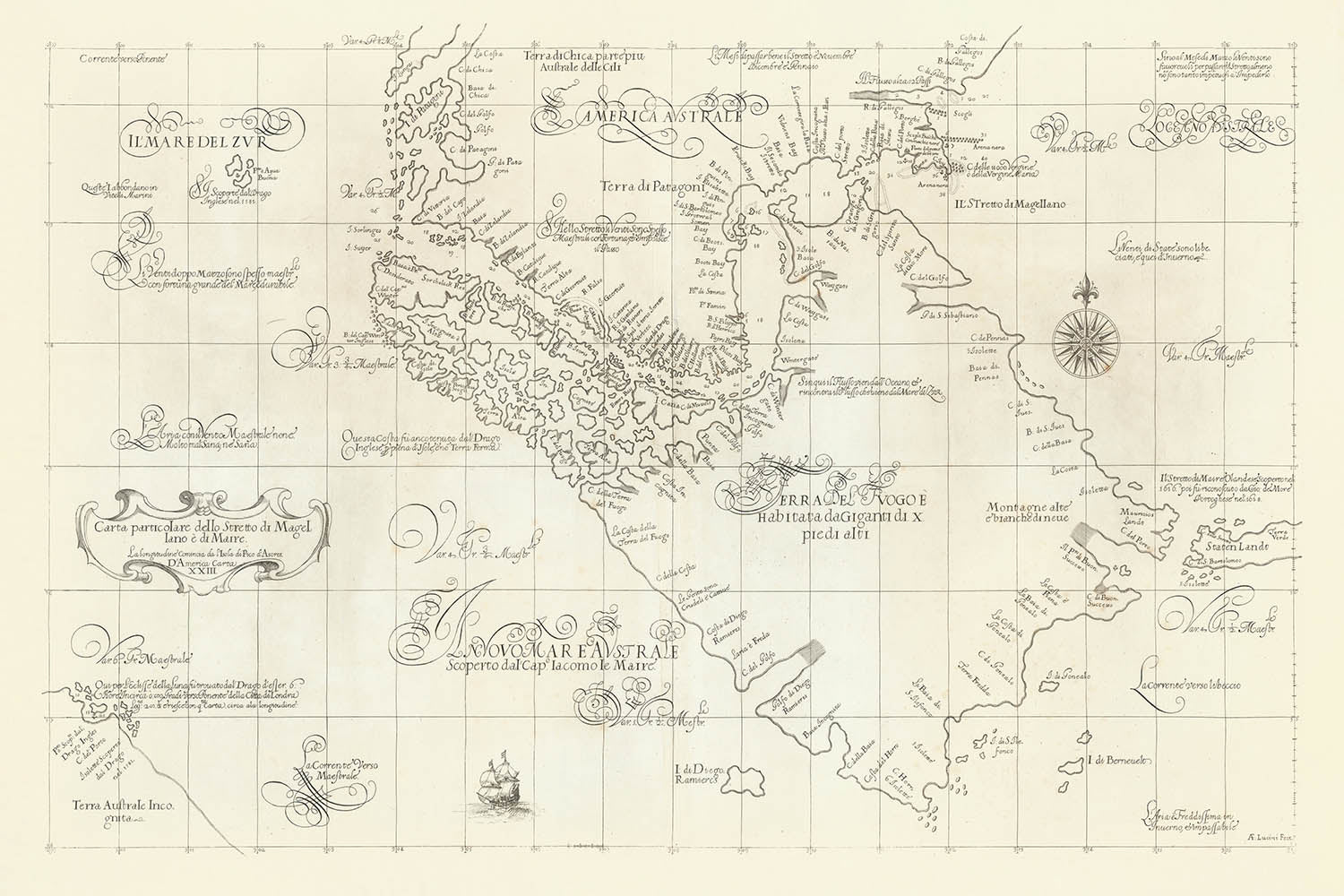
Entrez dans l'ère des découvertes avec le magnifique chart nautique de Robert Dudley de 1646, la "Carta Particolare dello Stretto di Magellano...
Continuer la lectureEntrez dans l'ère des découvertes avec le magnifique chart nautique de Robert Dudley de 1646, la "Carta Particolare dello Stretto di Magellano e di Maire." Cette carte remarquable capture les voies navigables dramatiques à l'extrémité sud de l'Amérique du Sud, y compris le légendaire détroit de Magellan et le nouvellement découvert détroit de Le Maire. Le chart de Dudley est un témoignage de la quête incessante de connaissance maritime de l'époque, offrant un aperçu des ambitions stratégiques et de l'esprit aventureux qui ont défini l'exploration du XVIIe siècle. Le principal objectif de la carte est la navigation, traçant des passages périlleux qui étaient vitaux pour le commerce mondial et la compétition impériale.
Ce qui distingue ce chart est son mélange magistral d'art et d'utilité. Le style élégant de Dudley est évident dans les contours côtiers précis, les roses des vents décoratives et le placement soigneux des sondages—des chiffres indiquant les profondeurs d'eau en brasses—le long des détroits et des côtes. Les bancs de sable, les canaux et les mouillages sont méticuleusement délimités, fournissant des conseils essentiels aux marins. Ces infographies, rares pour leur époque, reflètent l'engagement de Dudley envers l'exactitude et les besoins pratiques des marins, élevant la carte d'une simple illustration à un outil de navigation sophistiqué.
Le chart de Dudley est également une riche tapisserie des connaissances géographiques et des spéculations de l'époque. La Terre de Feu domine la carte en tant que vaste île, entourée d'une constellation de petits îlots, beaucoup étiquetés comme inconnus—un clin d'œil aux mystères qui enveloppaient encore la région. Les noms de lieux entourent les masses terrestres, provenant des voyages pionniers des explorateurs néerlandais Le Maire et Schouten, ainsi que des expéditions espagnoles envoyées en réponse aux découvertes néerlandaises. Ces annotations offrent un aperçu fascinant du transfert de connaissances entre les puissances européennes rivales et de la compréhension évolutive des frontières les plus méridionales du monde.
Ajoutant à l'intrigue, la carte préserve les mythes et légendes qui ont coloré les premières explorations. Une note faisant référence aux supposés géants de Patagonie, une histoire née du premier tour du monde de Magellan, suggère le mélange de fait et de folklore qui a accompagné ces voyages périlleux. En bas à gauche, Dudley inclut le continent austral insaisissable, ou Terra Australis, basé sur les récits de Sir Francis Drake—que Dudley connaissait personnellement. Cette masse terrestre spéculative souligne le sens de l'émerveillement de l'époque et la croyance persistante en des mondes non découverts au-delà des mers connues.
La signification historique de cette carte est profonde. En tant qu'un des premiers et des plus détaillés chartes maritimes de la région, elle reflète l'intense intérêt européen pour le contrôle de l'accès au Pacifique et l'esprit compétitif des empires maritimes. Les connexions de Dudley avec des explorateurs légendaires et ses techniques cartographiques innovantes font de ce chart non seulement une belle œuvre d'art mais aussi un document vital de la curiosité et de l'ambition humaines. Pour les collectionneurs et les connaisseurs, cela offre une rare opportunité de posséder un morceau de l'histoire aventureuse, énigmatique et toujours évolutive de l'exploration mondiale.
Endroits notables sur cette carte
- Le détroit de Magellan (Stretto di Magellano), le principal canal de navigation entre les océans Atlantique et Pacifique.
- Le détroit de Le Maire (Stretto di Maire), un passage secondaire à l'est de la Terre de Feu.
- La Terre de Feu (Terra del Fuoco), la grande île au sud du continent sud-américain.
- Isla de los Estados (Staten Island), située à l'est de la Terre de Feu.
- Cape Horn (Cabo Hornos), le cap le plus au sud de l'archipel, bien qu'il ne soit pas toujours clairement étiqueté sur les anciennes cartes.
- Divers petits îlots et rochers le long de la côte sud de la Terre de Feu, beaucoup marqués comme inconnus.
- Ports et mouillages notables le long des détroits, étiquetés pour une utilisation navigational.
- L'extrémité sud du continent sud-américain, au nord des détroits.
- Masse terrestre spéculative du Continent Sud (Terra Australis), comme mentionné par Drake.
- Caractéristiques côtières telles que baies, criques et promontoires, étiquetées avec des noms provenant des voyages contemporains.
Caractéristiques et monuments notables
- Contours côtiers détaillés et informations de navigation pour le détroit de Magellan et le détroit de Le Maire.
- Sonar (profondeurs d'eau en brasses) marqués tout au long des détroits et des zones côtières.
- Rose des vents pour la navigation, indiquant les directions et possiblement la déclinaison magnétique.
- Barres de sable et canaux d'eau délimités, aidant les marins à passer en toute sécurité.
- Noms de lieux entourant la Terre de Feu, dérivés des expéditions néerlandaises et espagnoles.
- Notes ou légendes faisant référence au mythe des géants, une croyance commune parmi les premiers explorateurs européens.
- Directions de navigation et annotations sur les meilleurs moments pour naviguer dans les détroits.
- Éléments décoratifs caractéristiques du style cartographique élégant de Dudley.
Contexte historique et de design
- Créé en 1646 par Robert Dudley, un explorateur anglais, cartographe et ingénieur naval connu pour son atlas maritime influent, Arcano del Mare.
- Une des premières et des plus détaillées cartes maritimes de la région, reflétant des connaissances et des spéculations à jour.
- Incorpore des données provenant des expéditions néerlandaises et espagnoles (Le Maire, Schouten, frères Nodales) et des explorateurs anglais (Drake, Cavendish).
- Se concentre sur la navigation, traçant des passages périlleux qui étaient vitaux pour le commerce mondial et la compétition impériale.
- Mélange d'art et d'utilité, avec des contours côtiers précis, des aides à la navigation et des roses des vents décoratives.
- Reflète l'intérêt intense des Européens pour le contrôle d'accès au Pacifique et l'esprit compétitif des empires maritimes.
- Préserve les mythes et légendes des premières explorations, tels que les supposés géants de Patagonie et le Continent Sud insaisissable.
- Fournit un aperçu rare et précieux de l'histoire aventureuse, énigmatique et en constante évolution de l'exploration mondiale.
Veuillez vérifier les images pour vous assurer qu'une ville ou un lieu spécifique est montré sur cette carte. Vous pouvez également nous contacter et nous demander de vérifier la carte pour vous.
Cette carte est magnifique à toutes les tailles, mais je recommande toujours d'opter pour une taille plus grande si vous avez de l'espace. De cette façon, vous pouvez facilement distinguer tous les détails.
Cette carte est incroyable à des tailles allant jusqu'à 100 pouces (250 cm). Si vous recherchez une carte plus grande, veuillez nous contacter.
Le modèle dans les images de la liste tient la version 24x36 pouces (60x90 cm) de cette carte.
La cinquième image de la liste montre un exemple de mon service de personnalisation de carte.
Si vous recherchez quelque chose de légèrement différent, consultez ma collection des meilleures anciennes cartes pour voir si quelque chose d'autre attire votre attention.
Veuillez me contacter pour vérifier si un certain emplacement, monument ou caractéristique est montré sur cette carte.
Cela ferait un merveilleux cadeau d'anniversaire, de Noël, pour la fête des pères, pour un départ au travail, un anniversaire de mariage ou une pendaison de crémaillère pour quelqu'un des zones couvertes par cette carte.
Cette carte est disponible en tant qu'impression giclée sur papier mat d'archives sans acide, ou vous pouvez l'acheter encadrée. Le cadre est un joli cadre noir simple qui convient à la plupart des esthétiques. Veuillez me contacter si vous souhaitez une couleur ou un matériau de cadre différent. Mes cadres sont vitrifiés avec un acrylique de musée super clair (perspex/acrylite), qui est significativement moins réfléchissant que le verre, plus sûr, et arrivera toujours en parfait état.
This map is also available as a float framed canvas, sometimes known as a shadow gap framed canvas or canvas floater. The map is printed on artist's cotton canvas and then stretched over a handmade box frame. We then "float" the canvas inside a wooden frame, which is available in a range of colours (black, dark brown, oak, antique gold and white). This is a wonderful way to present a map without glazing in front. See some examples of float framed canvas maps and explore the differences between my different finishes.
For something truly unique, this map is also available in "Unique 3D", our trademarked process that dramatically transforms the map so that it has a wonderful sense of depth. We combine the original map with detailed topography and elevation data, so that mountains and the terrain really "pop". For more info and examples of 3D maps, check my Unique 3D page.
Entrez dans l'ère des découvertes avec le magnifique chart nautique de Robert Dudley de 1646, la "Carta Particolare dello Stretto di Magellano e di Maire." Cette carte remarquable capture les voies navigables dramatiques à l'extrémité sud de l'Amérique du Sud, y compris le légendaire détroit de Magellan et le nouvellement découvert détroit de Le Maire. Le chart de Dudley est un témoignage de la quête incessante de connaissance maritime de l'époque, offrant un aperçu des ambitions stratégiques et de l'esprit aventureux qui ont défini l'exploration du XVIIe siècle. Le principal objectif de la carte est la navigation, traçant des passages périlleux qui étaient vitaux pour le commerce mondial et la compétition impériale.
Ce qui distingue ce chart est son mélange magistral d'art et d'utilité. Le style élégant de Dudley est évident dans les contours côtiers précis, les roses des vents décoratives et le placement soigneux des sondages—des chiffres indiquant les profondeurs d'eau en brasses—le long des détroits et des côtes. Les bancs de sable, les canaux et les mouillages sont méticuleusement délimités, fournissant des conseils essentiels aux marins. Ces infographies, rares pour leur époque, reflètent l'engagement de Dudley envers l'exactitude et les besoins pratiques des marins, élevant la carte d'une simple illustration à un outil de navigation sophistiqué.
Le chart de Dudley est également une riche tapisserie des connaissances géographiques et des spéculations de l'époque. La Terre de Feu domine la carte en tant que vaste île, entourée d'une constellation de petits îlots, beaucoup étiquetés comme inconnus—un clin d'œil aux mystères qui enveloppaient encore la région. Les noms de lieux entourent les masses terrestres, provenant des voyages pionniers des explorateurs néerlandais Le Maire et Schouten, ainsi que des expéditions espagnoles envoyées en réponse aux découvertes néerlandaises. Ces annotations offrent un aperçu fascinant du transfert de connaissances entre les puissances européennes rivales et de la compréhension évolutive des frontières les plus méridionales du monde.
Ajoutant à l'intrigue, la carte préserve les mythes et légendes qui ont coloré les premières explorations. Une note faisant référence aux supposés géants de Patagonie, une histoire née du premier tour du monde de Magellan, suggère le mélange de fait et de folklore qui a accompagné ces voyages périlleux. En bas à gauche, Dudley inclut le continent austral insaisissable, ou Terra Australis, basé sur les récits de Sir Francis Drake—que Dudley connaissait personnellement. Cette masse terrestre spéculative souligne le sens de l'émerveillement de l'époque et la croyance persistante en des mondes non découverts au-delà des mers connues.
La signification historique de cette carte est profonde. En tant qu'un des premiers et des plus détaillés chartes maritimes de la région, elle reflète l'intense intérêt européen pour le contrôle de l'accès au Pacifique et l'esprit compétitif des empires maritimes. Les connexions de Dudley avec des explorateurs légendaires et ses techniques cartographiques innovantes font de ce chart non seulement une belle œuvre d'art mais aussi un document vital de la curiosité et de l'ambition humaines. Pour les collectionneurs et les connaisseurs, cela offre une rare opportunité de posséder un morceau de l'histoire aventureuse, énigmatique et toujours évolutive de l'exploration mondiale.
Endroits notables sur cette carte
- Le détroit de Magellan (Stretto di Magellano), le principal canal de navigation entre les océans Atlantique et Pacifique.
- Le détroit de Le Maire (Stretto di Maire), un passage secondaire à l'est de la Terre de Feu.
- La Terre de Feu (Terra del Fuoco), la grande île au sud du continent sud-américain.
- Isla de los Estados (Staten Island), située à l'est de la Terre de Feu.
- Cape Horn (Cabo Hornos), le cap le plus au sud de l'archipel, bien qu'il ne soit pas toujours clairement étiqueté sur les anciennes cartes.
- Divers petits îlots et rochers le long de la côte sud de la Terre de Feu, beaucoup marqués comme inconnus.
- Ports et mouillages notables le long des détroits, étiquetés pour une utilisation navigational.
- L'extrémité sud du continent sud-américain, au nord des détroits.
- Masse terrestre spéculative du Continent Sud (Terra Australis), comme mentionné par Drake.
- Caractéristiques côtières telles que baies, criques et promontoires, étiquetées avec des noms provenant des voyages contemporains.
Caractéristiques et monuments notables
- Contours côtiers détaillés et informations de navigation pour le détroit de Magellan et le détroit de Le Maire.
- Sonar (profondeurs d'eau en brasses) marqués tout au long des détroits et des zones côtières.
- Rose des vents pour la navigation, indiquant les directions et possiblement la déclinaison magnétique.
- Barres de sable et canaux d'eau délimités, aidant les marins à passer en toute sécurité.
- Noms de lieux entourant la Terre de Feu, dérivés des expéditions néerlandaises et espagnoles.
- Notes ou légendes faisant référence au mythe des géants, une croyance commune parmi les premiers explorateurs européens.
- Directions de navigation et annotations sur les meilleurs moments pour naviguer dans les détroits.
- Éléments décoratifs caractéristiques du style cartographique élégant de Dudley.
Contexte historique et de design
- Créé en 1646 par Robert Dudley, un explorateur anglais, cartographe et ingénieur naval connu pour son atlas maritime influent, Arcano del Mare.
- Une des premières et des plus détaillées cartes maritimes de la région, reflétant des connaissances et des spéculations à jour.
- Incorpore des données provenant des expéditions néerlandaises et espagnoles (Le Maire, Schouten, frères Nodales) et des explorateurs anglais (Drake, Cavendish).
- Se concentre sur la navigation, traçant des passages périlleux qui étaient vitaux pour le commerce mondial et la compétition impériale.
- Mélange d'art et d'utilité, avec des contours côtiers précis, des aides à la navigation et des roses des vents décoratives.
- Reflète l'intérêt intense des Européens pour le contrôle d'accès au Pacifique et l'esprit compétitif des empires maritimes.
- Préserve les mythes et légendes des premières explorations, tels que les supposés géants de Patagonie et le Continent Sud insaisissable.
- Fournit un aperçu rare et précieux de l'histoire aventureuse, énigmatique et en constante évolution de l'exploration mondiale.
Veuillez vérifier les images pour vous assurer qu'une ville ou un lieu spécifique est montré sur cette carte. Vous pouvez également nous contacter et nous demander de vérifier la carte pour vous.
Cette carte est magnifique à toutes les tailles, mais je recommande toujours d'opter pour une taille plus grande si vous avez de l'espace. De cette façon, vous pouvez facilement distinguer tous les détails.
Cette carte est incroyable à des tailles allant jusqu'à 100 pouces (250 cm). Si vous recherchez une carte plus grande, veuillez nous contacter.
Le modèle dans les images de la liste tient la version 24x36 pouces (60x90 cm) de cette carte.
La cinquième image de la liste montre un exemple de mon service de personnalisation de carte.
Si vous recherchez quelque chose de légèrement différent, consultez ma collection des meilleures anciennes cartes pour voir si quelque chose d'autre attire votre attention.
Veuillez me contacter pour vérifier si un certain emplacement, monument ou caractéristique est montré sur cette carte.
Cela ferait un merveilleux cadeau d'anniversaire, de Noël, pour la fête des pères, pour un départ au travail, un anniversaire de mariage ou une pendaison de crémaillère pour quelqu'un des zones couvertes par cette carte.
Cette carte est disponible en tant qu'impression giclée sur papier mat d'archives sans acide, ou vous pouvez l'acheter encadrée. Le cadre est un joli cadre noir simple qui convient à la plupart des esthétiques. Veuillez me contacter si vous souhaitez une couleur ou un matériau de cadre différent. Mes cadres sont vitrifiés avec un acrylique de musée super clair (perspex/acrylite), qui est significativement moins réfléchissant que le verre, plus sûr, et arrivera toujours en parfait état.
This map is also available as a float framed canvas, sometimes known as a shadow gap framed canvas or canvas floater. The map is printed on artist's cotton canvas and then stretched over a handmade box frame. We then "float" the canvas inside a wooden frame, which is available in a range of colours (black, dark brown, oak, antique gold and white). This is a wonderful way to present a map without glazing in front. See some examples of float framed canvas maps and explore the differences between my different finishes.
For something truly unique, this map is also available in "Unique 3D", our trademarked process that dramatically transforms the map so that it has a wonderful sense of depth. We combine the original map with detailed topography and elevation data, so that mountains and the terrain really "pop". For more info and examples of 3D maps, check my Unique 3D page.
Many of our maps and art prints are chosen as thoughtful gifts for homes, offices, studies and meaningful places.
Choose a framed option for the easiest ready-to-hang gift, or choose an unframed print if the recipient may prefer to select their own frame.
We make orders locally in 23 countries around the world, so gifts can often be produced close to the recipient. This helps them arrive faster, travel more safely, and avoid customs or import duty surprises.
- We can deliver directly to the recipient
- Framed pieces arrive ready to hang
- Unframed prints are carefully packed in a strong protective tube
- Almost every order is made locally, for faster, safer gifting
- 90-day returns give the recipient time to decide
If you are not sure what to choose, please contact us. We can help you pick the right map, size, finish or delivery option.
Pour la plupart des commandes, le délai de livraison est d'environ 3 jours ouvrables. Les produits personnalisés et sur mesure prennent plus de temps, car je dois faire la personnalisation et vous l'envoyer pour approbation, ce qui prend généralement 1 ou 2 jours.
Veuillez noter que les grandes commandes encadrées prennent généralement plus de temps à réaliser et à livrer.
Si vous avez besoin que votre commande arrive à une date précise, veuillez me contacter avant de passer votre commande afin que nous puissions trouver le meilleur moyen de nous assurer que vous receviez votre commande à temps.
J'imprime et encadre des cartes et des œuvres d'art dans 23 pays à travers le monde. Cela signifie que votre commande sera réalisée localement, ce qui réduit le temps de livraison et garantit qu'elle ne sera pas endommagée pendant le transport. Vous ne paierez jamais de droits de douane ou d'importation, et nous mettrons moins de CO2 dans l'air.
Toutes mes cartes et impressions artistiques sont bien emballées et envoyées dans un tube robuste si non encadrées, ou entourées de mousse si encadrées.
J'essaie d'envoyer toutes les commandes dans les 1 ou 2 jours suivant la réception de votre commande, bien que certains produits (comme les masques, les mugs et les sacs fourre-tout) puissent prendre plus de temps à réaliser.
Si vous choisissez Livraison Express lors du paiement, nous donnerons la priorité à votre commande et l'enverrons par un service de messagerie de 1 jour (Fedex, DHL, UPS, Parcelforce).
La livraison le lendemain est également disponible dans certains pays (États-Unis, Royaume-Uni, Singapour, Émirats Arabes Unis), mais veuillez essayer de commander tôt dans la journée afin que nous puissions l'envoyer à temps.
Lisez mon guide complet sur la livraison et la production locale
Mon cadre standard est un cadre en bois dur noir de style galerie. Il est simple et a un aspect assez moderne. Mon cadre standard mesure environ 20 mm (0,8 po) de large.
J'utilise de l'acrylique super clair (perspex/acrylite) pour le verre du cadre. C'est plus léger et plus sûr que le verre - et cela a meilleur aspect, car la réflexivité est plus faible.
Six couleurs de cadre standard sont disponibles gratuitement (noir, marron foncé, gris foncé, chêne, blanc et or antique). Des encadrements et montages/matelassages personnalisés sont disponibles si vous recherchez autre chose.
La plupart des cartes, œuvres d'art et illustrations sont également disponibles sous forme de toile encadrée. Nous utilisons une toile en coton mate (non brillante), que nous tendons sur un cadre en bois de boîte provenant de sources durables, puis nous 'flottions' la pièce à l'intérieur d'un cadre en bois. Le résultat final est assez beau, et il n'y a pas de vitrage qui gêne.
Tous les cadres sont fournis "prêts à accrocher", avec soit une corde, soit des supports à l'arrière. Les très grands cadres auront des plaques de suspension lourdes et/ou une latte de montage. Si vous avez des questions, veuillez nous contacter.
Voir quelques exemples de mes cartes encadrées et de cartes en toile encadrées.
Alternativement, je peux également fournir de vieilles cartes et œuvres d'art sur toile, sur panneau en mousse, en coton et d'autres matériaux.
Si vous souhaitez encadrer votre carte ou œuvre d'art vous-même, veuillez lire d'abord mon guide des tailles.
Mes cartes sont des reproductions de cartes originales de très haute qualité.
Je recherche des cartes originales et rares auprès de bibliothèques, de maisons de ventes aux enchères et de collections privées du monde entier, je les restaure dans mon atelier de Londres, puis j'utilise des encres et des imprimantes giclées spécialisées pour créer de magnifiques cartes encore plus belles que l'originale.
Mes cartes sont imprimées sur du papier d’archives mat (non brillant) sans acide qui semble de très haute qualité et ressemble presque à une carte. En termes techniques, le grammage/épaisseur du papier est de 10 mil/200 g/m². C'est parfait pour l'encadrement.
J’imprime avec des encres pigmentaires Epson ultrachrome giclée UV résistantes à la décoloration – certaines des meilleures encres que vous puissiez trouver.
je peux aussi faire cartes sur toile, chiffon en coton et autres matériaux exotiques.
En savoir plus sur Unique Maps Co..
Personnalisation de la carte
Si vous recherchez le cadeau parfait pour un anniversaire ou une pendaison de crémaillère, je peux personnaliser votre carte pour la rendre vraiment unique. Par exemple, je peux ajouter un court message, mettre en évidence un lieu important ou ajouter les armoiries de votre famille.
Les options sont presque infinies. S'il vous plaît voir mon page de personnalisation de la carte pour quelques merveilleux exemples de ce qui est possible.
Pour commander une carte personnalisée, sélectionnez « personnaliser votre carte » avant de l'ajouter à votre panier.
Entrer en contact si vous recherchez des personnalisations et des personnalisations plus complexes.
Vieillissement de la carte
Au fil des ans, des clients m'ont demandé des centaines de fois s'ils pouvaient acheter une carte qui semble uniforme. plus vieux.
Eh bien, vous pouvez désormais le faire en sélectionnant Aged avant d'ajouter une carte à votre panier.
Toutes les photos de produits que vous voyez sur cette page montrent la carte dans sa forme originale. Voilà à quoi ressemble la carte aujourd'hui.
Si vous sélectionnez Vieilli, je vieillirai votre carte à la main, en utilisant un processus spécial et unique développé au cours d'années d'étude de cartes anciennes, de discussions avec des chercheurs pour comprendre la chimie du vieillissement du papier, et bien sûr... beaucoup de pratique !
Si vous n'êtes pas sûr, respectez la couleur originale de la carte. Si vous voulez quelque chose d'un peu plus sombre et plus vieux à la recherche, optez pour Aged.
Si vous n'êtes pas satisfait de votre commande pour une raison quelconque, contactez-moi pour un remboursement sans conditions. Veuillez consulter notre politique de retours et de remboursements pour plus d'informations.
Je suis très confiant que vous aimerez votre carte restaurée ou votre impression artistique. Je fais cela depuis 1984. Je suis un vendeur Etsy 5 étoiles. J'ai vendu des dizaines de milliers de cartes et d'impressions artistiques et j'ai plus de 5 000 vrais avis 5 étoiles.
J'utilise un processus unique pour restaurer des cartes et des œuvres d'art qui est extrêmement chronophage et exigeant en main-d'œuvre. Trouver les cartes et illustrations originales peut prendre des mois. J'utilise une technologie de pointe et incroyablement coûteuse pour les numériser et les restaurer. En conséquence, je garantis que mes cartes et impressions artistiques sont d'une qualité supérieure - c'est pourquoi je peux offrir un remboursement sans conditions.
Presque toutes mes cartes et impressions artistiques ont l'air incroyables en grandes tailles (200 cm, 6,5 pieds+) et je peux également les encadrer et vous les livrer, via un transporteur spécial surdimensionné. Contactez-moi pour discuter de vos besoins spécifiques.
Or try searching for something!


