

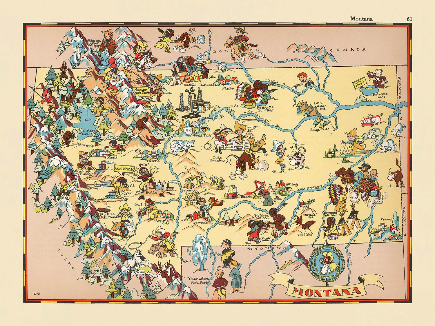


Carte picturale du Montana par Ruth Taylor White, 1935: Billings, Missoula, parcs nationaux de Yellowstone et Glacier, montagnes Rocheuses, rivière Missouri
Achetez 2, obtenez 1 gratuit
Si vous ajoutez 2 articles à votre panier, vous pouvez ajouter un troisième produit gratuitement.
Cela fonctionne pour toutes les cartes et œuvres d'art, y compris les pièces personnalisées et sur mesure. Vous pouvez commander 3 de la même chose, ou 3 choses différentes.
Cela équivaut à une remise de 33 %, qui sera la plus grande remise disponible dans ma boutique cette année.
Veuillez profiter de l'offre et couvrir vos murs de belles cartes et œuvres d'art !
Contactez-moi si vous avez des questions.

-
![]() Handmade locally in the EU
Handmade locally in the EU
-
FREE worldwide delivery in 2-3 days ⓘ
Free delivery in 2-3 days
Your map should be delivered in 2-3 working days with free delivery, worldwide.
Deliveries over the Christmas and New Year period may be slightly delayed, as couriers and postal services catch up with a huge backlog of packages.
We make maps by hand locally in 23 countries, including the EU
![]() . If you're buying a gift for someone in another country, we will make the map locally to them.
. If you're buying a gift for someone in another country, we will make the map locally to them.You will never pay import tax or customs duty.
Express delivery is available at checkout which can reduce the delivery time to 1-2 days.
Please note that personalised maps, and larger framed maps, can take longer to produce and deliver.
If you need your order to arrive by a certain date, contact me and we can discuss your options.
-
FREE gift preview
ⓘ
Digital gift preview
After you complete your order, you can send a beautiful digital preview to the gift recipient. Just provide their email address and we'll do the rest. (Their email address will not be stored or used for any other purpose.)
This is perfect if you're concerned that your order might not arrive in time.
You can also buy a real non-expiring gift card, and email it directly to the recipient, so they can buy their own map or artwork.
-
90 day money back guarantee
ⓘ
90 jours pour retourner et obtenir un remboursement
Les produits peuvent être retournés dans les 90 jours pour un remboursement complet, ou un échange contre un autre produit.
Pour les articles personnalisés et faits sur mesure, nous pouvons vous offrir un crédit en magasin ou une carte-cadeau non expirante, car nous ne pouvons pas revendre les commandes personnalisées.
Si vous avez des questions, contactez-nous. Pour plus d'informations, consultez notre politique de retours et d'échanges.

My maps are rare, museum-grade, restored old maps sourced from libraries, auction houses and private collections across the globe.
Framing & free personalisation available
1. Select your size
Click here to order a custom size.
2. Frame & personalise your map
Make your map unique with framing, hand-drawn customisation, vintage ageing, pop art text, unique 3D styling and more.


Message cadeau & finition personnalisée

Si vous souhaitez ajouter un message cadeau, ou une finition (puzzle, panneau en aluminium, etc.) qui n'est pas disponible ici, veuillez le demander dans la "note de commande" lors de votre passage à la caisse.
Chaque commande est fabriquée sur mesure, donc si vous avez besoin d'ajuster légèrement la taille, ou d'imprimer sur un matériau inhabituel, faites-le nous savoir. Nous avons réalisé des milliers de commandes personnalisées au fil des ans, donc il n'y a (presque) rien que nous ne puissions gérer.
Vous pouvez également nous contacter avant de passer votre commande, si vous le souhaitez !

- Handmade locally. No import duty or tax
- FREE worldwide delivery
- Love it or your money back (90 days)
- Questions? WhatsApp me any time
Own a piece of history
5,000+ 5 star reviews


Entrez dans le monde vibrant de l'Amérique des années 1930 avec « Montana », une carte picturale originale créée par la renommée Ruth Taylor White en 1935. Cette œuvre captivante est une célébration visuelle des vastes paysages du Montana et de son riche patrimoine culturel, rendue dans un style aussi fantaisiste qu'informatif. Le titre original de la carte, simplement « Montana », reflète son accent sur l'identité unique de l'État, invitant les spectateurs à explorer ses comtés, ses merveilles naturelles et son passé chargé d'histoire à travers une tapisserie de couleurs et d'illustrations.
Ruth Taylor White, célébrée pour sa série de cartes picturales des États, apporte un charme et un esprit distinctifs à ses créations cartographiques. Son travail se distingue par ses illustrations ludiques, semblables à des dessins animés, qui capturent à la fois l'esprit et les stéréotypes de l'époque. Dans « Montana », la main de White est évidente dans chaque détail, des cowboys animés conduisant du bétail à travers les plaines à la fière représentation de figures et de motifs amérindiens qui honorent le patrimoine indigène de l'État. Ses cartes étaient conçues non seulement pour informer mais aussi pour ravir, en faisant des objets de collection prisés pour ceux qui apprécient à la fois l'art et l'histoire.
Le design de la carte est un festin pour les yeux, utilisant des couleurs vives et des lignes audacieuses pour délimiter les comtés du Montana et mettre en valeur ses caractéristiques les plus emblématiques. Les majestueuses montagnes Rocheuses sont rendues avec un flair dramatique, leurs sommets s'élevant au-dessus de scènes de camps miniers animés et de forêts sereines. Au nord et au sud, le parc national des Glaciers et le parc national de Yellowstone sont illustrés avec une particulière révérence, soulignant leur importance en tant que trésors nationaux et merveilles naturelles. Le fleuve Missouri serpente gracieusement à travers la carte, un lien vital entre prairies et villes.
Au-delà de son exactitude géographique, « Montana » sert de fenêtre sur la vie économique et sociale de l'État au début du XXe siècle. Les illustrations regorgent de références à l'élevage, à l'exploitation minière, à l'agriculture et à l'exploitation forestière - des industries qui ont façonné le développement et l'identité du Montana. La faune, comme les ours, les bisons et les cerfs, erre librement à travers le paysage, tandis que des scènes de champs de blé et de fermes évoquent l'abondance agricole de la région. Les Grandes Plaines sont dépeintes avec des images de prairies étendues, contrastant magnifiquement avec les régions montagneuses boisées et les vallées fluviales.
Les villes et les villages, de Billings et Missoula à Great Falls et Bozeman, sont soigneusement marqués, chacun servant de porte d'entrée vers la nature environnante et la culture. Les vignettes animées de la carte et l'étiquetage méticuleux donnent vie à ces communautés, les situant dans un tableau plus large de monuments historiques, de beauté naturelle et d'esprit de frontière. « Montana » de Ruth Taylor White est plus qu'une carte - c'est une œuvre d'art et un document historique, offrant un aperçu rare et enchanteur du caractère de l'État du Trésor vu à travers les yeux de l'un des cartographes les plus imaginatifs d'Amérique.
Villes et villages sur cette carte
- Billings
- Missoula
- Great Falls
- Bozeman
- Butte
- Helena
- Kalispell
- Havre
- Miles City
- Livingston
- Glendive
- Sidney
- Lewistown
- Dillon
- Anaconda
- Deer Lodge
- Hamilton
- Cut Bank
- Shelby
- Wolf Point
Caractéristiques et monuments notables
- Le parc national de Yellowstone est représenté dans la partie sud de l'état.
- Le parc national des Glaciers est illustré dans la région nord-ouest.
- Les montagnes Rocheuses sont visuellement représentées avec des illustrations de montagnes proéminentes.
- Des figures et motifs amérindiens sont montrés, faisant référence au patrimoine culturel de la région.
- Des illustrations de cowboys et de bétail, mettant en avant la tradition de l'élevage du Montana.
- Des scènes d'activité minière, faisant référence à l'histoire minière du Montana.
- La faune, comme les ours, les bisons et les cerfs, est illustrée sur la carte.
- Des scènes agricoles, y compris des champs de blé et des animaux de ferme, sont dépeintes.
- Le fleuve Missouri est montré serpentant à travers l'état.
- Les Grandes Plaines sont représentées avec des images de prairie.
- Des zones forestières sont illustrées, indiquant les ressources forestières du Montana.
Contexte historique et de design
- Nom de la carte : Montana.
- Créateur de la carte originale : Ruth Taylor White.
- Date de création : 1935.
- Type de carte : Carte thématique et picturale de comté ou d'état.
- Style artistique : Hautement décoratif, utilisant des couleurs vives et des illustrations de style cartoon pour représenter les caractéristiques géographiques, culturelles et économiques.
- Focus thématique : Met en avant le caractère unique, l'histoire et la culture du Montana dans les années 1930, en utilisant des images stéréotypées et humoristiques.
- Couverture : Représente l'ensemble de l'état du Montana, avec des limites de comté clairement marquées.
- Importance historique : Fournit un récit visuel de l'identité du Montana au début du 20ème siècle, reflétant à la fois l'image de soi de l'état et les perceptions nationales.
- Valeur pour les collectionneurs : Considérée comme un exemple charmant et collectible de la cartographie picturale américaine du début du 20ème siècle.
- La carte reflète les tendances artistiques et les attitudes sociales des années 1930, y compris des stéréotypes spécifiques à l'époque.
Veuillez vérifier les images pour vous assurer qu'une ville ou un lieu spécifique est montré sur cette carte. Vous pouvez également nous contacter et nous demander de vérifier la carte pour vous.
Cette carte a fière allure à toutes les tailles, mais je recommande toujours d'opter pour une taille plus grande si vous avez de l'espace. De cette façon, vous pouvez facilement distinguer tous les détails.
Cette carte est magnifique à des tailles allant jusqu'à 50 pouces (125 cm). Si vous recherchez une carte plus grande, veuillez nous contacter.
Le modèle dans les images de la liste tient la version de cette carte de 18x24 pouces (45x60 cm).
La cinquième image de la liste montre un exemple de mon service de personnalisation de carte.
Si vous recherchez quelque chose de légèrement différent, consultez ma collection des meilleures anciennes cartes pour voir si quelque chose d'autre attire votre attention.
Veuillez me contacter pour vérifier si un certain emplacement, un point de repère ou une caractéristique est montré sur cette carte.
Cela ferait un merveilleux cadeau d'anniversaire, de Noël, pour la fête des pères, un départ de travail, un anniversaire ou une pendaison de crémaillère pour quelqu'un des régions couvertes par cette carte.
Cette carte est disponible en tant qu'impression giclée sur papier mat d'archive sans acide, ou vous pouvez l'acheter encadrée. Le cadre est un joli cadre noir simple qui convient à la plupart des esthétiques. Veuillez nous contacter si vous souhaitez une couleur ou un matériau de cadre différent. Mes cadres sont vitrées avec un acrylique de musée super clair (perspex/acrylite), qui est significativement moins réfléchissant que le verre, plus sûr, et arrivera toujours en parfait état.
This map is also available as a float framed canvas, sometimes known as a shadow gap framed canvas or canvas floater. The map is printed on artist's cotton canvas and then stretched over a handmade box frame. We then "float" the canvas inside a wooden frame, which is available in a range of colours (black, dark brown, oak, antique gold and white). This is a wonderful way to present a map without glazing in front. See some examples of float framed canvas maps and explore the differences between my different finishes.
For something truly unique, this map is also available in "Unique 3D", our trademarked process that dramatically transforms the map so that it has a wonderful sense of depth. We combine the original map with detailed topography and elevation data, so that mountains and the terrain really "pop". For more info and examples of 3D maps, check my Unique 3D page.
Pour la plupart des commandes, le délai de livraison est d'environ 3 jours ouvrables. Les produits personnalisés et sur mesure prennent plus de temps, car je dois faire la personnalisation et vous l'envoyer pour approbation, ce qui prend généralement 1 ou 2 jours.
Veuillez noter que les grandes commandes encadrées prennent généralement plus de temps à réaliser et à livrer.
Si vous avez besoin que votre commande arrive à une date précise, veuillez me contacter avant de passer votre commande afin que nous puissions trouver le meilleur moyen de nous assurer que vous receviez votre commande à temps.
J'imprime et encadre des cartes et des œuvres d'art dans 23 pays à travers le monde. Cela signifie que votre commande sera réalisée localement, ce qui réduit le temps de livraison et garantit qu'elle ne sera pas endommagée pendant le transport. Vous ne paierez jamais de droits de douane ou d'importation, et nous mettrons moins de CO2 dans l'air.
Toutes mes cartes et impressions artistiques sont bien emballées et envoyées dans un tube robuste si non encadrées, ou entourées de mousse si encadrées.
J'essaie d'envoyer toutes les commandes dans les 1 ou 2 jours suivant la réception de votre commande, bien que certains produits (comme les masques, les mugs et les sacs fourre-tout) puissent prendre plus de temps à réaliser.
Si vous choisissez Livraison Express lors du paiement, nous donnerons la priorité à votre commande et l'enverrons par un service de messagerie de 1 jour (Fedex, DHL, UPS, Parcelforce).
La livraison le lendemain est également disponible dans certains pays (États-Unis, Royaume-Uni, Singapour, Émirats Arabes Unis), mais veuillez essayer de commander tôt dans la journée afin que nous puissions l'envoyer à temps.
Lisez mon guide complet sur la livraison et la production locale
Mon cadre standard est un cadre en bois dur noir de style galerie. Il est simple et a un aspect assez moderne. Mon cadre standard mesure environ 20 mm (0,8 po) de large.
J'utilise de l'acrylique super clair (perspex/acrylite) pour le verre du cadre. C'est plus léger et plus sûr que le verre - et cela a meilleur aspect, car la réflexivité est plus faible.
Six couleurs de cadre standard sont disponibles gratuitement (noir, marron foncé, gris foncé, chêne, blanc et or antique). Des encadrements et montages/matelassages personnalisés sont disponibles si vous recherchez autre chose.
La plupart des cartes, œuvres d'art et illustrations sont également disponibles sous forme de toile encadrée. Nous utilisons une toile en coton mate (non brillante), que nous tendons sur un cadre en bois de boîte provenant de sources durables, puis nous 'flottions' la pièce à l'intérieur d'un cadre en bois. Le résultat final est assez beau, et il n'y a pas de vitrage qui gêne.
Tous les cadres sont fournis "prêts à accrocher", avec soit une corde, soit des supports à l'arrière. Les très grands cadres auront des plaques de suspension lourdes et/ou une latte de montage. Si vous avez des questions, veuillez nous contacter.
Voir quelques exemples de mes cartes encadrées et de cartes en toile encadrées.
Alternativement, je peux également fournir de vieilles cartes et œuvres d'art sur toile, sur panneau en mousse, en coton et d'autres matériaux.
Si vous souhaitez encadrer votre carte ou œuvre d'art vous-même, veuillez lire d'abord mon guide des tailles.
Certaines de mes anciennes cartes sont maintenant disponibles en tant que toiles encadrées. Veuillez me contacter si vous souhaitez commander une taille qui n'est pas disponible dans ma boutique.
Les anciennes cartes en toile sont une alternative intéressante aux cartes encadrées de manière conventionnelle. Selon vos goûts personnels et la décoration de votre pièce, les cartes en toile peuvent "se démarquer" un peu plus qu'une carte encadrée.
Mes cartes sont des reproductions de cartes originales de très haute qualité.
Je recherche des cartes originales et rares auprès de bibliothèques, de maisons de ventes aux enchères et de collections privées du monde entier, je les restaure dans mon atelier de Londres, puis j'utilise des encres et des imprimantes giclées spécialisées pour créer de magnifiques cartes encore plus belles que l'originale.
Mes cartes sont imprimées sur du papier d’archives mat (non brillant) sans acide qui semble de très haute qualité et ressemble presque à une carte. En termes techniques, le grammage/épaisseur du papier est de 10 mil/200 g/m². C'est parfait pour l'encadrement.
J’imprime avec des encres pigmentaires Epson ultrachrome giclée UV résistantes à la décoloration – certaines des meilleures encres que vous puissiez trouver.
je peux aussi faire cartes sur toile, chiffon en coton et autres matériaux exotiques.
En savoir plus sur Unique Maps Co..
Personnalisation de la carte
Si vous recherchez le cadeau parfait pour un anniversaire ou une pendaison de crémaillère, je peux personnaliser votre carte pour la rendre vraiment unique. Par exemple, je peux ajouter un court message, mettre en évidence un lieu important ou ajouter les armoiries de votre famille.
Les options sont presque infinies. S'il vous plaît voir mon page de personnalisation de la carte pour quelques merveilleux exemples de ce qui est possible.
Pour commander une carte personnalisée, sélectionnez « personnaliser votre carte » avant de l'ajouter à votre panier.
Entrer en contact si vous recherchez des personnalisations et des personnalisations plus complexes.
Vieillissement de la carte
Au fil des ans, des clients m'ont demandé des centaines de fois s'ils pouvaient acheter une carte qui semble uniforme. plus vieux.
Eh bien, vous pouvez désormais le faire en sélectionnant Aged avant d'ajouter une carte à votre panier.
Toutes les photos de produits que vous voyez sur cette page montrent la carte dans sa forme originale. Voilà à quoi ressemble la carte aujourd'hui.
Si vous sélectionnez Vieilli, je vieillirai votre carte à la main, en utilisant un processus spécial et unique développé au cours d'années d'étude de cartes anciennes, de discussions avec des chercheurs pour comprendre la chimie du vieillissement du papier, et bien sûr... beaucoup de pratique !
Si vous n'êtes pas sûr, respectez la couleur originale de la carte. Si vous voulez quelque chose d'un peu plus sombre et plus vieux à la recherche, optez pour Aged.
Si vous n'êtes pas satisfait de votre commande pour une raison quelconque, contactez-moi pour un remboursement sans conditions. Veuillez consulter notre politique de retours et de remboursements pour plus d'informations.
Je suis très confiant que vous aimerez votre carte restaurée ou votre impression artistique. Je fais cela depuis 1984. Je suis un vendeur Etsy 5 étoiles. J'ai vendu des dizaines de milliers de cartes et d'impressions artistiques et j'ai plus de 5 000 vrais avis 5 étoiles.
J'utilise un processus unique pour restaurer des cartes et des œuvres d'art qui est extrêmement chronophage et exigeant en main-d'œuvre. Trouver les cartes et illustrations originales peut prendre des mois. J'utilise une technologie de pointe et incroyablement coûteuse pour les numériser et les restaurer. En conséquence, je garantis que mes cartes et impressions artistiques sont d'une qualité supérieure - c'est pourquoi je peux offrir un remboursement sans conditions.
Presque toutes mes cartes et impressions artistiques ont l'air incroyables en grandes tailles (200 cm, 6,5 pieds+) et je peux également les encadrer et vous les livrer, via un transporteur spécial surdimensionné. Contactez-moi pour discuter de vos besoins spécifiques.
Or try searching for something!


