


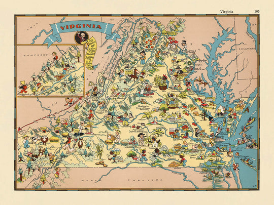


Carte picturale de la Virginie par Ruth Taylor White, 1935: Richmond, Norfolk, baie de Chesapeake, montagnes Blue Ridge, Jamestown
20% de réduction sur 2 — 33% de réduction sur 3
Ajoutez n'importe quel deux articles éligibles à votre panier pour recevoir 20% de réduction. Ajoutez un troisième et il sera offert (équivalent à 33% de réduction lors de l'achat de trois).
Aucun code nécessaire — l'offre s'applique automatiquement au moment du paiement.
Valide sur toutes les cartes standard et les impressions d'art. Vous pouvez mélanger et assortir n'importe quel design.
Si vous souhaitez expédier des articles à plusieurs adresses, veuillez nous contacter avant de passer votre commande.
Les commandes personnalisées et sur mesure sont exclues.
Contactez-nous si vous avez des questions
-
![]() Handmade locally in the EU
Handmade locally in the EU

-
FREE worldwide delivery in 2-3 days ⓘ
Free delivery in 2-3 days
Your map should be delivered in 2-3 working days with free delivery, worldwide.
We make maps by hand locally in 23 countries, including the EU
![]() . If you're buying a gift for someone in another country, we will make the map locally to them.
. If you're buying a gift for someone in another country, we will make the map locally to them.You will never pay import tax or customs duty.
Express delivery is available at checkout which can reduce the delivery time to 1-2 days.
Please note that personalised maps, and larger framed maps, can take longer to produce and deliver.
If you need your order to arrive by a certain date, contact me and we can discuss your options.
-
Complimentary gifting & design advice
ⓘ
Complimentary gifting & design advice
Available almost 24/7 on WhatsApp and email — we usually reply within minutes. We can help you:
- Choose a perfectly personalised gift
- Send a digital gift preview to the recipient
- Pick the ideal size for your wall
- Select the right finish and frame
Quick, friendly advice so you can order with confidence.
For last minute gifts, consider buying a digital gift card. We have over 5,000 maps and art prints to choose from.
-
90-day returns & 5-year guarantee
ⓘ
90 jours pour retourner et obtenir un remboursement
Les produits peuvent être retournés dans les 90 jours pour un remboursement complet, ou un échange contre un autre produit.
Pour les articles personnalisés et faits sur mesure, nous pouvons vous offrir un crédit en magasin ou une carte-cadeau non expirante, car nous ne pouvons pas revendre les commandes personnalisées.
Si vous avez des questions, contactez-nous. Pour plus d'informations, consultez notre politique de retours et d'échanges.

This is a museum-grade archival print from the original 1935 map — restored in our workshop and made to order on 220gsm archival matte paper or 400gsm artist's cotton canvas with pigment inks.
Professional framing & free personalisation available.
1. Choose a size
2. Frame & personalise your map
Make your map unique with framing, hand-drawn customisation, vintage ageing, pop art text, unique 3D styling and more.


Message cadeau & finition personnalisée

Si vous souhaitez ajouter un message cadeau, ou une finition (puzzle, panneau en aluminium, etc.) qui n'est pas disponible ici, veuillez le demander dans la "note de commande" lors de votre passage à la caisse.
Chaque commande est fabriquée sur mesure, donc si vous avez besoin d'ajuster légèrement la taille, ou d'imprimer sur un matériau inhabituel, faites-le nous savoir. Nous avons réalisé des milliers de commandes personnalisées au fil des ans, donc il n'y a (presque) rien que nous ne puissions gérer.
Vous pouvez également nous contacter avant de passer votre commande, si vous le souhaitez !

- Handmade locally. No import duty or tax
- FREE worldwide delivery
- 90-day returns & 5-year product guarantee
- Questions? WhatsApp me any time
Own a piece of history
7,000+ 5 star reviews


Entrez dans le monde captivant de l'Amérique des années 1930 avec "Virginie," le titre original de cette carte picturale enchantée créée par la célèbre Ruth Taylor White en 1935. Cette carte est une célébration vivante de l'identité unique de la Virginie, mise en lumière par le mélange signature de fantaisie et d'art de White. Chaque coin de l'état est orné d'illustrations colorées qui évoquent l'essence des paysages, des traditions et du passé légendaire de la Virginie.
Ruth Taylor White, célébrée pour son approche imaginative de la cartographie, a infusé ce travail d'un esprit à la fois ludique et profondément informatif. Sa collaboration avec l'éditeur Frank J. Taylor a donné lieu à une série d'atlas picturaux qui ont transformé la façon dont les Américains percevaient leur pays. Dans "Virginie," l'art de White est indéniable—elle combine habilement des vignettes de style cartoon avec des limites de comté précises, transformant la carte en un tableau vivant à la fois éducatif et décoratif. Ses illustrations ne se contentent pas d'embellir la carte; elles racontent le pouls culturel et historique de l'état.
Le design de cette carte est un témoignage de la fascination de l'époque pour l'identité régionale et la couleur locale. Les champs de tabac, les figures coloniales et les scènes de plantation évoquent l'héritage agricole et colonial de la Virginie, tandis que les représentations de chevaux et d'activités maritimes mettent en lumière les traditions équestres et côtières de l'état. Les montagnes Blue Ridge se dressent dans des teintes douces, et la baie de Chesapeake est rendue avec un éclat, ancrant la carte dans sa géographie distinctive. Chaque élément visuel est choisi avec soin pour représenter les industries, les paysages et les histoires qui ont défini la Virginie au début du XXe siècle.
Ce qui distingue cette carte, c'est sa capacité à tisser ensemble les jalons historiques de l'état avec sa vie quotidienne. Les illustrations de soldats de la guerre de Sécession et de scènes de bataille rappellent le rôle central de la Virginie dans l'histoire américaine, tandis que les références à Jamestown et au patrimoine amérindien ancrent la carte dans les premiers chapitres de l'état. L'inclusion de motifs agricoles—vergers de pommiers, fermes de cacahuètes et champs expansifs—offre un aperçu de la vitalité économique de la région. Des éléments décoratifs tels qu'une rose des vents et des bordures ornées complètent la composition, en faisant un festin visuel tant pour l'observateur occasionnel que pour l'historien averti.
Au-delà de son attrait artistique, la carte est un remarquable témoignage des paysages urbains et ruraux de la Virginie tels qu'ils étaient perçus dans les années 1930. Les grandes villes et les villages, y compris Richmond, Norfolk et Charlottesville, sont élégamment étiquetés, ancrant le spectateur dans un territoire familier tout en invitant à explorer des lieux moins connus. L'absence d'infrastructures modernes et l'accent mis sur les monuments culturels et naturels reflètent une époque où les cartes étaient conçues pour inspirer la curiosité et la conversation. Ce n'est pas qu'une carte—c'est une tapisserie vibrante de l'héritage de la Virginie, destinée à être chérie par les collectionneurs, les passionnés d'histoire et les amoureux de la cartographie fine.
Villes et villages sur cette carte
- Richmond
- Virginia Beach
- Norfolk
- Chesapeake
- Arlington
- Newport News
- Alexandria
- Hampton
- Roanoke
- Portsmouth
- Suffolk
- Lynchburg
- Harrisonburg
- Charlottesville
- Danville
- Manassas
- Petersburg
- Winchester
- Salem
- Staunton
Caractéristiques et monuments notables
- Illustrations de la culture du tabac, reflétant la dépendance économique historique de la Virginie au tabac
- Représentations de figures de l'époque coloniale et de scènes de plantations, faisant référence au patrimoine colonial de la Virginie
- Représentations artistiques de chevaux et d'élevage de chevaux, un clin d'œil aux traditions équestres de la Virginie
- Images de navires et références à l'histoire côtière et maritime de l'État
- Illustrations de soldats de la guerre civile et de scènes de bataille, soulignant le rôle de la Virginie dans la guerre civile américaine
- Dessins d'activités agricoles telles que des vergers de pommes et la culture des arachides
- Références visuelles aux montagnes Blue Ridge et à la région des Appalaches
- Représentation artistique de la baie de Chesapeake et de son importance pour l'État
- Éléments picturaux faisant référence à Jamestown, le premier établissement anglais permanent en Amérique
- Illustrations de manoirs historiques et de maisons de plantation
- Allusions visuelles à l'héritage amérindien de l'État
- Représentation de la devise et/ou du sceau de l'État dans la bordure ou la légende de la carte
- Animaux et faune de style cartoon, tels que des cerfs et des oiseaux, natifs de la Virginie
- Rose des vents décorative et éléments de bordure ornés
Contexte historique et de design
- Titre original : Virginie
- Créé par Ruth Taylor White en 1935, une illustratrice renommée connue pour ses cartes picturales fantaisistes
- Publié par Frank J. Taylor, souvent crédité en tant qu'éditeur ou éditeur de la série d'atlas picturaux
- Illustrations fantaisistes, colorées, de style cartoon mêlant géographie et narration visuelle
- Se concentre sur des scènes stéréotypées et caractéristiques de la Virginie des années 1930, y compris des activités culturelles, historiques et économiques
- Réflète la culture, le mode de vie et les caractéristiques notables de la Virginie dans les années 1930, offrant un aperçu des perceptions et des valeurs de l'époque
- Fait partie d'une série d'atlas picturaux plus large couvrant divers États américains, destinée à éduquer et à divertir
- Les illustrations servent à la fois de décoration et de commentaire, faisant de la carte une pièce de conversation et un artefact historique
- Apprécié par les collectionneurs de cartes vintage, les historiens et ceux intéressés par l'Amérique et l'illustration de l'époque
Veuillez vérifier les images pour vous assurer qu'une ville ou un lieu spécifique est montré sur cette carte. Vous pouvez également nous contacter et nous demander de vérifier la carte pour vous.
Cette carte est magnifique à toutes les tailles, mais je recommande toujours d'opter pour une taille plus grande si vous avez de l'espace. De cette façon, vous pouvez facilement distinguer tous les détails.
Cette carte a l'air incroyable dans des tailles allant jusqu'à 50 pouces (125 cm). Si vous recherchez une carte plus grande, veuillez nous contacter.
Le modèle sur les images de la liste tient la version 18x24 pouces (45x60 cm) de cette carte.
L'image de la cinquième liste montre un exemple de mon service de personnalisation de carte.
Si vous recherchez quelque chose d'un peu différent, consultez ma collection des meilleures anciennes cartes pour voir si quelque chose d'autre attire votre attention.
Veuillez me contacter pour vérifier si un certain emplacement, monument ou caractéristique est montré sur cette carte.
Cela ferait un merveilleux cadeau d'anniversaire, de Noël, pour la fête des pères, pour un départ au travail, un anniversaire ou une pendaison de crémaillère pour quelqu'un des régions couvertes par cette carte.
Cette carte est disponible en tant qu'impression giclée sur papier mat archivé sans acide, ou vous pouvez l'acheter encadrée. Le cadre est un joli cadre noir simple qui convient à la plupart des esthétiques. Veuillez me contacter si vous souhaitez une couleur ou un matériau de cadre différent. Mes cadres sont vitrées avec de l'acrylique de qualité musée super clair (perspex/acrylite), qui est significativement moins réfléchissant que le verre, plus sûr, et arrivera toujours en parfait état.
This map is also available as a float framed canvas, sometimes known as a shadow gap framed canvas or canvas floater. The map is printed on artist's cotton canvas and then stretched over a handmade box frame. We then "float" the canvas inside a wooden frame, which is available in a range of colours (black, dark brown, oak, antique gold and white). This is a wonderful way to present a map without glazing in front. See some examples of float framed canvas maps and explore the differences between my different finishes.
For something truly unique, this map is also available in "Unique 3D", our trademarked process that dramatically transforms the map so that it has a wonderful sense of depth. We combine the original map with detailed topography and elevation data, so that mountains and the terrain really "pop". For more info and examples of 3D maps, check my Unique 3D page.
Pour la plupart des commandes, le délai de livraison est d'environ 3 jours ouvrables. Les produits personnalisés et sur mesure prennent plus de temps, car je dois faire la personnalisation et vous l'envoyer pour approbation, ce qui prend généralement 1 ou 2 jours.
Veuillez noter que les grandes commandes encadrées prennent généralement plus de temps à réaliser et à livrer.
Si vous avez besoin que votre commande arrive à une date précise, veuillez me contacter avant de passer votre commande afin que nous puissions trouver le meilleur moyen de nous assurer que vous receviez votre commande à temps.
J'imprime et encadre des cartes et des œuvres d'art dans 23 pays à travers le monde. Cela signifie que votre commande sera réalisée localement, ce qui réduit le temps de livraison et garantit qu'elle ne sera pas endommagée pendant le transport. Vous ne paierez jamais de droits de douane ou d'importation, et nous mettrons moins de CO2 dans l'air.
Toutes mes cartes et impressions artistiques sont bien emballées et envoyées dans un tube robuste si non encadrées, ou entourées de mousse si encadrées.
J'essaie d'envoyer toutes les commandes dans les 1 ou 2 jours suivant la réception de votre commande, bien que certains produits (comme les masques, les mugs et les sacs fourre-tout) puissent prendre plus de temps à réaliser.
Si vous choisissez Livraison Express lors du paiement, nous donnerons la priorité à votre commande et l'enverrons par un service de messagerie de 1 jour (Fedex, DHL, UPS, Parcelforce).
La livraison le lendemain est également disponible dans certains pays (États-Unis, Royaume-Uni, Singapour, Émirats Arabes Unis), mais veuillez essayer de commander tôt dans la journée afin que nous puissions l'envoyer à temps.
Lisez mon guide complet sur la livraison et la production locale
Mon cadre standard est un cadre en bois dur noir de style galerie. Il est simple et a un aspect assez moderne. Mon cadre standard mesure environ 20 mm (0,8 po) de large.
J'utilise de l'acrylique super clair (perspex/acrylite) pour le verre du cadre. C'est plus léger et plus sûr que le verre - et cela a meilleur aspect, car la réflexivité est plus faible.
Six couleurs de cadre standard sont disponibles gratuitement (noir, marron foncé, gris foncé, chêne, blanc et or antique). Des encadrements et montages/matelassages personnalisés sont disponibles si vous recherchez autre chose.
La plupart des cartes, œuvres d'art et illustrations sont également disponibles sous forme de toile encadrée. Nous utilisons une toile en coton mate (non brillante), que nous tendons sur un cadre en bois de boîte provenant de sources durables, puis nous 'flottions' la pièce à l'intérieur d'un cadre en bois. Le résultat final est assez beau, et il n'y a pas de vitrage qui gêne.
Tous les cadres sont fournis "prêts à accrocher", avec soit une corde, soit des supports à l'arrière. Les très grands cadres auront des plaques de suspension lourdes et/ou une latte de montage. Si vous avez des questions, veuillez nous contacter.
Voir quelques exemples de mes cartes encadrées et de cartes en toile encadrées.
Alternativement, je peux également fournir de vieilles cartes et œuvres d'art sur toile, sur panneau en mousse, en coton et d'autres matériaux.
Si vous souhaitez encadrer votre carte ou œuvre d'art vous-même, veuillez lire d'abord mon guide des tailles.
Certaines de mes anciennes cartes sont maintenant disponibles en tant que toiles encadrées. Veuillez me contacter si vous souhaitez commander une taille qui n'est pas disponible dans ma boutique.
Les anciennes cartes en toile sont une alternative intéressante aux cartes encadrées de manière conventionnelle. Selon vos goûts personnels et la décoration de votre pièce, les cartes en toile peuvent "se démarquer" un peu plus qu'une carte encadrée.
Mes cartes sont des reproductions de cartes originales de très haute qualité.
Je recherche des cartes originales et rares auprès de bibliothèques, de maisons de ventes aux enchères et de collections privées du monde entier, je les restaure dans mon atelier de Londres, puis j'utilise des encres et des imprimantes giclées spécialisées pour créer de magnifiques cartes encore plus belles que l'originale.
Mes cartes sont imprimées sur du papier d’archives mat (non brillant) sans acide qui semble de très haute qualité et ressemble presque à une carte. En termes techniques, le grammage/épaisseur du papier est de 10 mil/200 g/m². C'est parfait pour l'encadrement.
J’imprime avec des encres pigmentaires Epson ultrachrome giclée UV résistantes à la décoloration – certaines des meilleures encres que vous puissiez trouver.
je peux aussi faire cartes sur toile, chiffon en coton et autres matériaux exotiques.
En savoir plus sur Unique Maps Co..
Personnalisation de la carte
Si vous recherchez le cadeau parfait pour un anniversaire ou une pendaison de crémaillère, je peux personnaliser votre carte pour la rendre vraiment unique. Par exemple, je peux ajouter un court message, mettre en évidence un lieu important ou ajouter les armoiries de votre famille.
Les options sont presque infinies. S'il vous plaît voir mon page de personnalisation de la carte pour quelques merveilleux exemples de ce qui est possible.
Pour commander une carte personnalisée, sélectionnez « personnaliser votre carte » avant de l'ajouter à votre panier.
Entrer en contact si vous recherchez des personnalisations et des personnalisations plus complexes.
Vieillissement de la carte
Au fil des ans, des clients m'ont demandé des centaines de fois s'ils pouvaient acheter une carte qui semble uniforme. plus vieux.
Eh bien, vous pouvez désormais le faire en sélectionnant Aged avant d'ajouter une carte à votre panier.
Toutes les photos de produits que vous voyez sur cette page montrent la carte dans sa forme originale. Voilà à quoi ressemble la carte aujourd'hui.
Si vous sélectionnez Vieilli, je vieillirai votre carte à la main, en utilisant un processus spécial et unique développé au cours d'années d'étude de cartes anciennes, de discussions avec des chercheurs pour comprendre la chimie du vieillissement du papier, et bien sûr... beaucoup de pratique !
Si vous n'êtes pas sûr, respectez la couleur originale de la carte. Si vous voulez quelque chose d'un peu plus sombre et plus vieux à la recherche, optez pour Aged.
Si vous n'êtes pas satisfait de votre commande pour une raison quelconque, contactez-moi pour un remboursement sans conditions. Veuillez consulter notre politique de retours et de remboursements pour plus d'informations.
Je suis très confiant que vous aimerez votre carte restaurée ou votre impression artistique. Je fais cela depuis 1984. Je suis un vendeur Etsy 5 étoiles. J'ai vendu des dizaines de milliers de cartes et d'impressions artistiques et j'ai plus de 5 000 vrais avis 5 étoiles.
J'utilise un processus unique pour restaurer des cartes et des œuvres d'art qui est extrêmement chronophage et exigeant en main-d'œuvre. Trouver les cartes et illustrations originales peut prendre des mois. J'utilise une technologie de pointe et incroyablement coûteuse pour les numériser et les restaurer. En conséquence, je garantis que mes cartes et impressions artistiques sont d'une qualité supérieure - c'est pourquoi je peux offrir un remboursement sans conditions.
Presque toutes mes cartes et impressions artistiques ont l'air incroyables en grandes tailles (200 cm, 6,5 pieds+) et je peux également les encadrer et vous les livrer, via un transporteur spécial surdimensionné. Contactez-moi pour discuter de vos besoins spécifiques.
Or try searching for something!


