


Rare Old Central USA Topographic Map by Bartholomew, 1922: Gulf routes, Mississippi R., Houston, Dallas, New Orleans
La oferta del coleccionista
Elija dos obras elegibles y obtenga un 20 % de descuento en ambas. Elija tres y la de menor precio será gratuita, con un ahorro máximo del 33 %.
Combine y mezcle mapas estándar elegibles y reproducciones de bellas artes. No se requiere código; la oferta se aplica automáticamente al finalizar la compra.
Se incluyen las configuraciones estándar hechas por encargo. Quedan excluidos los tamaños a medida, los diseños personalizados y los trabajos por encargo.
¿Necesita entrega en diferentes direcciones? Contáctenos antes de realizar el pedido.La oferta del coleccionista
Elija dos obras elegibles y obtenga un 20 % de descuento en ambas. Elija tres y la de menor precio será gratuita, con un ahorro máximo del 33 %.
Combine y mezcle mapas estándar elegibles y reproducciones de bellas artes. No se requiere código; la oferta se aplica automáticamente al finalizar la compra.
Se incluyen las configuraciones estándar hechas por encargo. Quedan excluidos los tamaños a medida, los diseños personalizados y los trabajos por encargo.
¿Necesita entrega en diferentes direcciones? Contáctenos antes de realizar el pedido. Diseñado en Londres Hecho en la UE
Diseñado en Londres • Hecho en la UE
Diseñado en Londres Hecho en la UE
Diseñado en Londres • Hecho en la UE

Restaurado a partir del mapa original de 1922 e impreso en calidad museo. Leer la historia detrás de este mapa
Choose your size
Choose your finish


(Más información)
Mensaje de regalo y acabado personalizado

Si deseas agregar un mensaje de regalo, o un acabado (rompecabezas, tablero de aluminio, etc.) que no esté disponible aquí, por favor solicítalo en la "nota del pedido" cuando realices la compra.
Cada pedido es hecho a medida, así que si necesitas que el tamaño se ajuste ligeramente, o que se imprima en un material inusual, háznoslo saber. Hemos realizado miles de pedidos personalizados a lo largo de los años, así que hay (casi) nada que no podamos gestionar.
También puedes contactarnos antes de hacer tu pedido, ¡si lo prefieres!

- Hecho localmente. Entrega segura
- Sin aranceles ni cargos ocultos
- ¿Necesitas ayuda? Llámanos o mensaje por WhatsApp
Own a piece of history
8,000+ five-star reviews


United States - central section is John George Bartholomew’s 1922 vision of the American heartland, issued by the Edinburgh Geographical Institute as...
Seguir leyendoUnited States - central section is John George Bartholomew’s 1922 vision of the American heartland, issued by the Edinburgh Geographical Institute as the second iteration of the landmark 1920 edition. It marks a decisive stylistic and technical shift from the earlier, Andree-influenced 1895 tradition, embracing Bartholomew’s own cartographic language of color, clarity, and analytical precision. Hypsometric tints model the land’s rise from the Gulf littoral to interior uplands, while bathymetric shadings contour the coastal shallows where trade awakened the region to the world. Shipping routes with measured distances lace the Gulf of Mexico, underscoring the map’s practical orientation toward navigation and commerce. The design is quintessentially early twentieth century—restrained, rigorous, and quietly authoritative.
Bartholomew’s color gradients render the central United States as a living topography. The low, humid arc of the Gulf Coastal Plain deepens through greens into warmer ochres and browns over the Texas Hill Country, the Ouachita and Ozark highlands, and the Cumberland uplifts. Spot heights prick the relief with numerical certainty, while river systems—Mississippi, Arkansas, Red, Trinity, Brazos, and the Colorado of Texas—trace the arteries that fed cotton, timber, and oil economies. Along the coast, bathymetric tints hint at shelves and deeps, a subtle guide to approach and passage. The Mississippi Delta’s fans and bayous are set against a backdrop of measured elevation, revealing at a glance why floodplains, bluffs, and terraces shaped settlement, agriculture, and transport.
The political portrait is equally exacting, with state boundaries for Texas, Louisiana, Mississippi, Arkansas, and Tennessee delineated in clean, confident strokes that never smother the physical story beneath. A constellation of cities anchors the composition: Houston rising out of the coastal bayous; Dallas and Fort Worth astride the Trinity watershed; San Antonio and Austin stepping across the Hill Country; Memphis gripping the Mississippi’s east bank; New Orleans poised at the river’s mouth; Baton Rouge, Little Rock, and Nashville each commanding their riverine corridors. Their placement converts the page into an atlas of influence—where river bends dictate harbors, uplands host capitals, and trade routes braid interior markets with Gulf ports and onward to the Caribbean and Atlantic worlds.
John George Bartholomew, often hailed as the “Prince of Cartography,” codified a modern cartographic aesthetic that fused scientific method with painterly restraint. Under his Edinburgh Geographical Institute, hypsometric tints became an instrument of explanation rather than ornament, harmonized with precise typography, judicious linework, and carefully tabulated spot heights. This 1922 issue encapsulates that philosophy, departing from the venerable, more textural Germanic conventions associated with Andree to a cleaner, British cosmopolitan clarity. Its disciplined presentation signals the lineage that would mature into future editions of The Times Atlas, where global geography, commercial intelligence, and visual legibility coalesced into a single authoritative reference for scholars, statesmen, travelers, and traders.
The map speaks to a transformative moment in American and global commerce. In the early 1920s, oilfields expanded across Texas and Louisiana, the Mississippi remained the republic’s commercial spine, and the Panama Canal reoriented sea distances—facts legible here in the measured shipping routes radiating from Gulf ports. Distances plotted between key waypoints convert the coast from mere shoreline into a navigational matrix, while bathymetric tints intimate safe water and offshore approach. By wedding those maritime cues to an inland lattice of elevations, rivers, and borders, Bartholomew captured a region on the cusp of modernity—its landscapes, cities, and trade corridors all mapped with a precision that turns information into insight, and geography into narrative.
Cities and towns on this map
- Houston, Texas
- Dallas, Texas
- San Antonio, Texas
- Austin, Texas
- Fort Worth, Texas
- Memphis, Tennessee
- New Orleans, Louisiana
- Baton Rouge, Louisiana
- Little Rock, Arkansas
- Nashville, Tennessee
Notable Features & Landmarks
- Hypsometric Tints: Displaying elevation changes across the region.
- Bathymetric Tints: Indicating water depths along the coastal areas.
- Shipping Routes: Illustrated paths with marked distances.
- Spot Heights: Numerical values showing specific elevations at notable points.
- Borders: Clearly delineated boundaries for states.
Historical and design context
- Mapmaker/Publisher: Created by John George Bartholomew in 1922, published by the Edinburgh Geographical Institute.
- Historical Significance: Second issue of the 1920 edition—first to fully employ Bartholomew’s techniques—departing from Andree’s work in the 1895 edition.
- Topics and Themes: Detailed political and physical illustrations combining relief, bathymetry, and shipping routes.
- Design and Style: Hypsometric tints to represent elevation; vintage early 20th-century cartographic style emphasizing navigation and trade routes.
- Practical Application: Focus on shipping routes and distances for early 20th-century navigation.
- Publication Legacy: Precursor to future editions of The Times Atlas, continuing a lineage of cartographic excellence.
Please double check the images to make sure that a specific town or place is shown on this map. You can also get in touch and ask us to check the map for you.
This map looks great at every size, but I always recommend going for a larger size if you have space. That way you can easily make out all of the details.
This map looks amazing at sizes all the way up to 70in (180cm). If you are looking for a larger map, please get in touch.
Please note: the labels on this map are hard to read if you order a map that is 16in (40cm) or smaller. The map is still very attractive, but if you would like to read the map easily, please buy a larger size.
The model in the listing images is holding the 16x20in (40x50cm) version of this map.
The fifth listing image shows an example of my map personalisation service.
If you’re looking for something slightly different, check out my collection of the best old maps to see if something else catches your eye.
Please contact me to check if a certain location, landmark or feature is shown on this map.
This would make a wonderful birthday, Christmas, Father's Day, work leaving, anniversary or housewarming gift for someone from the areas covered by this map.
This map is available as a giclée print on acid free archival matte paper, or you can buy it framed. The frame is a nice, simple black frame that suits most aesthetics. Please get in touch if you'd like a different frame colour or material. My frames are glazed with super-clear museum-grade acrylic (perspex/acrylite), which is significantly less reflective than glass, safer, and will always arrive in perfect condition.
This map is also available as a float framed canvas, sometimes known as a shadow gap framed canvas or canvas floater. The map is printed on artist's cotton canvas and then stretched over a handmade box frame. We then "float" the canvas inside a wooden frame, which is available in a range of colours (black, dark brown, oak, antique gold and white). This is a wonderful way to present a map without glazing in front. See some examples of float framed canvas maps and explore the differences between my different finishes.
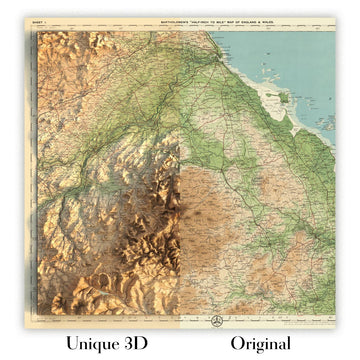
For something truly unique, this map is also available in "Unique 3D", our trademarked process that dramatically transforms the map so that it has a wonderful sense of depth. We combine the original map with detailed topography and elevation data, so that mountains and the terrain really "pop". For more info and examples of 3D maps, check my Unique 3D page.
United States - central section is John George Bartholomew’s 1922 vision of the American heartland, issued by the Edinburgh Geographical Institute as the second iteration of the landmark 1920 edition. It marks a decisive stylistic and technical shift from the earlier, Andree-influenced 1895 tradition, embracing Bartholomew’s own cartographic language of color, clarity, and analytical precision. Hypsometric tints model the land’s rise from the Gulf littoral to interior uplands, while bathymetric shadings contour the coastal shallows where trade awakened the region to the world. Shipping routes with measured distances lace the Gulf of Mexico, underscoring the map’s practical orientation toward navigation and commerce. The design is quintessentially early twentieth century—restrained, rigorous, and quietly authoritative.
Bartholomew’s color gradients render the central United States as a living topography. The low, humid arc of the Gulf Coastal Plain deepens through greens into warmer ochres and browns over the Texas Hill Country, the Ouachita and Ozark highlands, and the Cumberland uplifts. Spot heights prick the relief with numerical certainty, while river systems—Mississippi, Arkansas, Red, Trinity, Brazos, and the Colorado of Texas—trace the arteries that fed cotton, timber, and oil economies. Along the coast, bathymetric tints hint at shelves and deeps, a subtle guide to approach and passage. The Mississippi Delta’s fans and bayous are set against a backdrop of measured elevation, revealing at a glance why floodplains, bluffs, and terraces shaped settlement, agriculture, and transport.
The political portrait is equally exacting, with state boundaries for Texas, Louisiana, Mississippi, Arkansas, and Tennessee delineated in clean, confident strokes that never smother the physical story beneath. A constellation of cities anchors the composition: Houston rising out of the coastal bayous; Dallas and Fort Worth astride the Trinity watershed; San Antonio and Austin stepping across the Hill Country; Memphis gripping the Mississippi’s east bank; New Orleans poised at the river’s mouth; Baton Rouge, Little Rock, and Nashville each commanding their riverine corridors. Their placement converts the page into an atlas of influence—where river bends dictate harbors, uplands host capitals, and trade routes braid interior markets with Gulf ports and onward to the Caribbean and Atlantic worlds.
John George Bartholomew, often hailed as the “Prince of Cartography,” codified a modern cartographic aesthetic that fused scientific method with painterly restraint. Under his Edinburgh Geographical Institute, hypsometric tints became an instrument of explanation rather than ornament, harmonized with precise typography, judicious linework, and carefully tabulated spot heights. This 1922 issue encapsulates that philosophy, departing from the venerable, more textural Germanic conventions associated with Andree to a cleaner, British cosmopolitan clarity. Its disciplined presentation signals the lineage that would mature into future editions of The Times Atlas, where global geography, commercial intelligence, and visual legibility coalesced into a single authoritative reference for scholars, statesmen, travelers, and traders.
The map speaks to a transformative moment in American and global commerce. In the early 1920s, oilfields expanded across Texas and Louisiana, the Mississippi remained the republic’s commercial spine, and the Panama Canal reoriented sea distances—facts legible here in the measured shipping routes radiating from Gulf ports. Distances plotted between key waypoints convert the coast from mere shoreline into a navigational matrix, while bathymetric tints intimate safe water and offshore approach. By wedding those maritime cues to an inland lattice of elevations, rivers, and borders, Bartholomew captured a region on the cusp of modernity—its landscapes, cities, and trade corridors all mapped with a precision that turns information into insight, and geography into narrative.
Cities and towns on this map
- Houston, Texas
- Dallas, Texas
- San Antonio, Texas
- Austin, Texas
- Fort Worth, Texas
- Memphis, Tennessee
- New Orleans, Louisiana
- Baton Rouge, Louisiana
- Little Rock, Arkansas
- Nashville, Tennessee
Notable Features & Landmarks
- Hypsometric Tints: Displaying elevation changes across the region.
- Bathymetric Tints: Indicating water depths along the coastal areas.
- Shipping Routes: Illustrated paths with marked distances.
- Spot Heights: Numerical values showing specific elevations at notable points.
- Borders: Clearly delineated boundaries for states.
Historical and design context
- Mapmaker/Publisher: Created by John George Bartholomew in 1922, published by the Edinburgh Geographical Institute.
- Historical Significance: Second issue of the 1920 edition—first to fully employ Bartholomew’s techniques—departing from Andree’s work in the 1895 edition.
- Topics and Themes: Detailed political and physical illustrations combining relief, bathymetry, and shipping routes.
- Design and Style: Hypsometric tints to represent elevation; vintage early 20th-century cartographic style emphasizing navigation and trade routes.
- Practical Application: Focus on shipping routes and distances for early 20th-century navigation.
- Publication Legacy: Precursor to future editions of The Times Atlas, continuing a lineage of cartographic excellence.
Please double check the images to make sure that a specific town or place is shown on this map. You can also get in touch and ask us to check the map for you.
This map looks great at every size, but I always recommend going for a larger size if you have space. That way you can easily make out all of the details.
This map looks amazing at sizes all the way up to 70in (180cm). If you are looking for a larger map, please get in touch.
Please note: the labels on this map are hard to read if you order a map that is 16in (40cm) or smaller. The map is still very attractive, but if you would like to read the map easily, please buy a larger size.
The model in the listing images is holding the 16x20in (40x50cm) version of this map.
The fifth listing image shows an example of my map personalisation service.
If you’re looking for something slightly different, check out my collection of the best old maps to see if something else catches your eye.
Please contact me to check if a certain location, landmark or feature is shown on this map.
This would make a wonderful birthday, Christmas, Father's Day, work leaving, anniversary or housewarming gift for someone from the areas covered by this map.
This map is available as a giclée print on acid free archival matte paper, or you can buy it framed. The frame is a nice, simple black frame that suits most aesthetics. Please get in touch if you'd like a different frame colour or material. My frames are glazed with super-clear museum-grade acrylic (perspex/acrylite), which is significantly less reflective than glass, safer, and will always arrive in perfect condition.
This map is also available as a float framed canvas, sometimes known as a shadow gap framed canvas or canvas floater. The map is printed on artist's cotton canvas and then stretched over a handmade box frame. We then "float" the canvas inside a wooden frame, which is available in a range of colours (black, dark brown, oak, antique gold and white). This is a wonderful way to present a map without glazing in front. See some examples of float framed canvas maps and explore the differences between my different finishes.
For something truly unique, this map is also available in "Unique 3D", our trademarked process that dramatically transforms the map so that it has a wonderful sense of depth. We combine the original map with detailed topography and elevation data, so that mountains and the terrain really "pop". For more info and examples of 3D maps, check my Unique 3D page.
Many of our maps and art prints are chosen as thoughtful gifts for homes, offices, studies and meaningful places.
Choose a framed option for the easiest ready-to-hang gift, or choose an unframed print if the recipient may prefer to select their own frame.
We make orders locally in 23 countries around the world, so gifts can often be produced close to the recipient. This helps them arrive faster, travel more safely, and avoid customs or import duty surprises.
- We can deliver directly to the recipient
- Framed pieces arrive ready to hang
- Unframed prints are carefully packed in a strong protective tube
- Almost every order is made locally, for faster, safer gifting
- 90-day returns give the recipient time to decide
If you are not sure what to choose, please contact us. We can help you pick the right map, size, finish or delivery option.
Para la mayoría de los pedidos, el tiempo de entrega es de aproximadamente 3 días laborables. Los productos personalizados y a medida tardan más, ya que tengo que hacer la personalización y enviártelo para su aprobación, lo cual suele tardar 1 o 2 días.
Tenga en cuenta que los pedidos enmarcados muy grandes suelen tardar más en fabricarse y entregarse.
Si necesitas que tu pedido llegue para una fecha determinada, por favor contáctame antes de hacer el pedido para que podamos encontrar la mejor manera de asegurarnos de que recibas tu pedido a tiempo.
Imprimo y enmarco mapas y obras de arte en 23 países alrededor del mundo. Esto significa que tu pedido se fabricará localmente, lo que reduce el tiempo de entrega y asegura que no se dañe durante el envío. Nunca pagarás aranceles de aduana o impuestos de importación, y pondremos menos CO2 en el aire.
Todos mis mapas y impresiones artísticas están bien empaquetados y enviados en un tubo resistente si no están enmarcados, o rodeados de espuma si están enmarcados.
Intento enviar todos los pedidos dentro de 1 o 2 días después de recibir tu pedido, aunque algunos productos (como mascarillas, tazas y bolsas de tela) pueden tardar más en fabricarse.
Si seleccionas Entrega Exprés al finalizar la compra, priorizaremos tu pedido y lo enviaremos por mensajería de 1 día (Fedex, DHL, UPS, Parcelforce).
La entrega al día siguiente también está disponible en algunos países (EE. UU., Reino Unido, Singapur, EAU), pero por favor intenta hacer tu pedido temprano en el día para que podamos enviarlo a tiempo.
Mi marco estándar es un marco de madera de fresno negro estilo galería. Es simple y tiene un aspecto bastante moderno. Mi marco estándar tiene alrededor de 20 mm (0.8 in) de ancho.
Utilizo acrílico super claro (perspex/acrylite) para el vidrio del marco. Es más ligero y seguro que el vidrio, y se ve mejor, ya que la reflectividad es menor.
Seis colores de marco estándar están disponibles de forma gratuita (negro, marrón oscuro, gris oscuro, roble, blanco y oro antiguo).El enmarcado y montaje/matizado personalizado está disponible si buscas algo diferente.
La mayoría de los mapas, arte e ilustraciones también están disponibles como un lienzo enmarcado. Utilizamos lienzo de algodón mate (no brillante), lo estiramos sobre un marco de madera de caja de origen sostenible, y luego 'flotamos' la pieza dentro de un marco de madera. El resultado final es bastante hermoso, y no hay cristal que se interponga.
Todos los marcos se proporcionan "listos para colgar", con una cuerda o soportes en la parte posterior. Los marcos muy grandes tendrán placas de colgar de alta resistencia y/o un listón de montaje. Si tienes alguna pregunta, por favor ponte en contacto.
Mira algunos ejemplos de mis mapas enmarcados y mapas en lienzo enmarcados.
Alternativamente, también puedo proporcionar mapas antiguos y obras de arte en lienzo, tablero de espuma, papel de algodón y otros materiales.
Si deseas enmarcar tu mapa o obra de arte tú mismo, por favor lee mi guía de tamaños primero.
Mis mapas son reproducciones de mapas originales de altísima calidad.
Obtengo mapas originales y raros de bibliotecas, casas de subastas y colecciones privadas de todo el mundo, los restauro en mi taller de Londres y luego uso tintas e impresoras giclée especializadas para crear hermosos mapas que lucen incluso mejor que el original.
Mis mapas están impresos en papel de archivo mate (no brillante) sin ácido que se siente de muy alta calidad y casi como una tarjeta. En términos técnicos, el peso/grosor del papel es de 10 mil/200 g/m². Es perfecto para enmarcar.
Imprimo con tintas pigmentadas Epson ultrachrome giclée UV resistentes a la decoloración, algunas de las mejores tintas que puedes encontrar.
yo también puedo hacer mapas sobre lienzo, trapo de algodón y otros materiales exóticos.
Obtenga más información sobre The Unique Maps Co..
Personalización de mapas
Si está buscando el regalo perfecto de aniversario o inauguración de la casa, puedo personalizar su mapa para hacerlo verdaderamente único. Por ejemplo, puedo agregar un mensaje corto, resaltar una ubicación importante o agregar el escudo de armas de su familia.
Las opciones son casi infinitas. Por favor mira mi página de personalización de mapas para ver algunos maravillosos ejemplos de lo que es posible.
Para pedir un mapa personalizado, seleccione "personalizar su mapa" antes de agregarlo a su carrito.
Ponerse en contacto si buscas personalizaciones y personalizaciones más complejas.
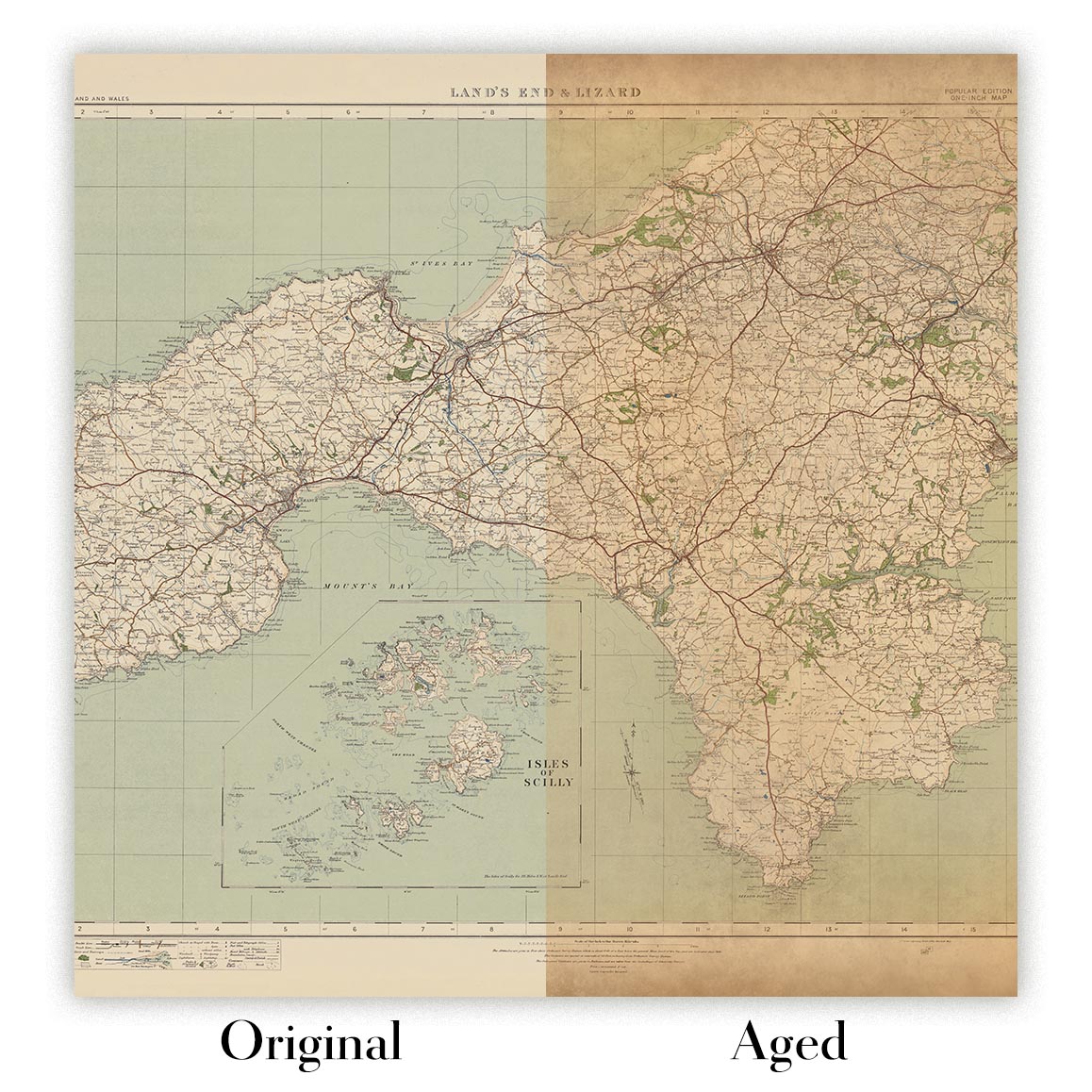
Envejecimiento del mapa
A lo largo de los años, los clientes me han preguntado cientos de veces si podían comprar un mapa que se viera uniforme. más viejo.
Bueno, ahora puedes hacerlo seleccionando Envejecido antes de agregar un mapa a tu carrito.
Todas las fotografías de productos que ve en esta página muestran el mapa en su forma original. Así es como se ve el mapa hoy.
Si selecciona Envejecido, envejeceré su mapa a mano, usando un proceso especial y único desarrollado a través de años de estudiar mapas antiguos, hablar con investigadores para comprender la química del envejecimiento del papel y, por supuesto... ¡mucha práctica!
Si no estás seguro, quédate con el color original del mapa. Si quieres algo un poco más oscuro y más viejo buscando, opte por Envejecido.
Si no estás satisfecho con tu pedido por cualquier motivo, contáctame para un reembolso sin complicaciones. Por favor, consulta nuestra política de devoluciones y reembolsos para más información.
Estoy muy seguro de que te gustará tu mapa o impresión artística restaurada. He estado haciendo esto desde 1984. Soy un vendedor de 5 estrellas en Etsy. He vendido decenas de miles de mapas e impresiones artísticas y tengo más de 5,000 opiniones reales de 5 estrellas.
Utilizo un proceso único para restaurar mapas y obras de arte que consume mucho tiempo y mano de obra. Buscar los mapas e ilustraciones originales puede llevar meses. Utilizo tecnología de última generación y extremadamente cara para escanear y restaurarlos. Como resultado, garantizo que mis mapas e impresiones artísticas son superiores a los demás - por eso puedo ofrecer un reembolso sin complicaciones.
Casi todos mis mapas e impresiones artísticas se ven increíbles en tamaños grandes (200cm, 6.5ft+) y también puedo enmarcarlos y entregártelos a través de un servicio de mensajería especial para tamaños grandes. Contáctame para discutir tus necesidades específicas.
Or try searching for something!


