


Mapa antiguo del oeste de Canadá de Bartholomew, 1922: Vancouver, Calgary, Winnipeg, Yukón-Mackenzie, Montañas Rocosas
La oferta del coleccionista
Elija dos obras elegibles y obtenga un 20 % de descuento en ambas. Elija tres y la de menor precio será gratuita, con un ahorro máximo del 33 %.
Combine y mezcle mapas estándar elegibles y reproducciones de bellas artes. No se requiere código; la oferta se aplica automáticamente al finalizar la compra.
Se incluyen las configuraciones estándar hechas por encargo. Quedan excluidos los tamaños a medida, los diseños personalizados y los trabajos por encargo.
¿Necesita entrega en diferentes direcciones? Contáctenos antes de realizar el pedido.La oferta del coleccionista
Elija dos obras elegibles y obtenga un 20 % de descuento en ambas. Elija tres y la de menor precio será gratuita, con un ahorro máximo del 33 %.
Combine y mezcle mapas estándar elegibles y reproducciones de bellas artes. No se requiere código; la oferta se aplica automáticamente al finalizar la compra.
Se incluyen las configuraciones estándar hechas por encargo. Quedan excluidos los tamaños a medida, los diseños personalizados y los trabajos por encargo.
¿Necesita entrega en diferentes direcciones? Contáctenos antes de realizar el pedido. Diseñado en Londres Hecho en la UE
Diseñado en Londres • Hecho en la UE
Diseñado en Londres Hecho en la UE
Diseñado en Londres • Hecho en la UE

Restaurado a partir del mapa original de 1922 e impreso en calidad museo. Leer la historia detrás de este mapa
Choose your size
Choose your finish


(Más información)
Mensaje de regalo y acabado personalizado

Si deseas agregar un mensaje de regalo, o un acabado (rompecabezas, tablero de aluminio, etc.) que no esté disponible aquí, por favor solicítalo en la "nota del pedido" cuando realices la compra.
Cada pedido es hecho a medida, así que si necesitas que el tamaño se ajuste ligeramente, o que se imprima en un material inusual, háznoslo saber. Hemos realizado miles de pedidos personalizados a lo largo de los años, así que hay (casi) nada que no podamos gestionar.
También puedes contactarnos antes de hacer tu pedido, ¡si lo prefieres!

- Hecho localmente. Entrega segura
- Sin aranceles ni cargos ocultos
- ¿Necesitas ayuda? Llámanos o mensaje por WhatsApp
Own a piece of history
8,000+ five-star reviews


Sumérjase en los paisajes cargados de historia del Canadá de principios del siglo XX con “Western Canada”, el mapa original de 1922...
Seguir leyendoSumérjase en los paisajes cargados de historia del Canadá de principios del siglo XX con “Western Canada”, el mapa original de 1922 magistralmente elaborado por John George Bartholomew. Llevando con orgullo su título histórico, este mapa recoge una época crucial en la que las vastas extensiones de Columbia Británica, Alberta, Saskatchewan, Manitoba y el singular distrito federal del río Yukon-Mackenzie iban adquiriendo una definición administrativa y geográfica más precisa. Como segundo tiraje de la edición de 1920, marca una transición significativa en la excelencia cartográfica, al ser el primer mapa del Times Atlas en utilizar el meticuloso enfoque de Bartholomew, una mejora respecto a los mapas de Andree de finales del siglo XIX. Este cambio no solo elevó la precisión del atlas, sino que también señaló una nueva era en la representación visual de los dominios occidentales de Canadá.
La maestría cartográfica de Bartholomew se despliega plenamente mediante el sofisticado uso de tintes hipsométricos y cotas puntuales, que representan con elegancia el dramático relieve de las Montañas Rocosas, las Montañas Costeras y la Meseta Laurentiana. La interacción entre color y contorno da vida a las praderas onduladas, las tierras escarpadas del Escudo y los picos cubiertos de nieve que definen la geografía de la región. Los tintes batimétricos enriquecen aún más la representación, sombreando con precisión científica las profundidades de la bahía de Hudson, el Gran Lago del Esclavo y el lago Winnipeg. Cada detalle, desde los sinuosos ríos Mackenzie y Fraser hasta la intrincada red de rutas marítimas, es testimonio de la dedicación de Bartholomew tanto a la belleza como a la exactitud.
El contexto histórico de este mapa es igualmente cautivador. Creado en una época en que las fronteras occidentales de Canadá evolucionaban con rapidez, recoge la efímera existencia del distrito federal del río Yukon-Mackenzie, una rara organización administrativa que habla de la dinámica gobernanza de los territorios septentrionales. La frontera internacional con Estados Unidos está trazada con nitidez, reflejando tanto las realidades políticas como el legado de la negociación continental. Cabe destacar que la inclusión de notas de corrección de la edición original de 1920 demuestra un compromiso inquebrantable con la información actualizada, garantizando que cada detalle siga siendo una referencia fiable tanto para historiadores como para coleccionistas.
Un recorrido por este mapa revela un paisaje rebosante tanto de maravillas naturales como de asentamientos en expansión. Las ciudades y poblaciones —Vancouver, Calgary, Winnipeg, Regina, Dawson y más— están elegantemente inscritas, con su prominencia actual anticipada por la mano cuidadosa de Bartholomew. Ríos como el Peace, el Athabasca y el Columbia serpentean por el terreno, mientras que los campos auríferos de Cariboo y las cordilleras Selkirk aluden a la rica historia de exploración y descubrimiento de recursos de la región. El Círculo Polar Ártico y las vastas praderas de las Provincias de las Praderas se representan con claridad, subrayando la diversidad y la escala de los entornos del oeste de Canadá.
John George Bartholomew, a menudo aclamado como “el Príncipe de los Cartógrafos”, fue célebre por su innovadora cartografía temática y su incansable búsqueda de la verdad geográfica. Su legado queda indeleblemente plasmado en este mapa, que se erige a la vez como una obra de arte y un documento de relevancia histórica. Para el coleccionista exigente o el historiador apasionado, “Western Canada” es más que un mapa: es una ventana a una época transformadora, una celebración del progreso científico y un tributo al perdurable encanto del oeste canadiense.
Ciudades y poblaciones en este mapa
- Columbia Británica
- Vancouver
- Victoria
- New Westminster
- Prince Rupert
- Kamloops
- Nanaimo
- Alberta
- Calgary
- Edmonton
- Lethbridge
- Medicine Hat
- Red Deer
- Saskatchewan
- Saskatoon
- Regina
- Moose Jaw
- Prince Albert
- Manitoba
- Winnipeg
- Brandon
- Portage la Prairie
- Yukon
- Dawson
- Whitehorse
- Distrito de Mackenzie
- Fort Smith
- Fort Resolution
- Fort Simpson
Características y hitos notables
- Las Montañas Rocosas, representadas de forma destacada con tintes hipsométricos
- El río Mackenzie, mostrado como una vía fluvial principal
- El distrito federal del río Yukon-Mackenzie, una singular región administrativa histórica
- El Escudo Canadiense, indicado mediante un sombreado topográfico distintivo
- La bahía de Hudson, con tintes batimétricos que ilustran la profundidad de las aguas
- El lago Great Slave y el lago Great Bear, importantes lagos del norte
- El río Fraser, un río clave en la Columbia Británica
- El río Columbia, señalado como una vía fluvial significativa
- El lago Winnipeg, un gran lago interior en Manitoba
- La frontera internacional entre Canadá y Estados Unidos, claramente delimitada
- Principales rutas marítimas a través del océano Pacífico, con distancias indicadas
- La frontera de Alaska, que refleja el límite histórico con Estados Unidos
- El río Peace, un río importante del norte de Alberta y la Columbia Británica
- El río Athabasca, otro importante sistema fluvial
- La región de los yacimientos auríferos de Cariboo, históricamente significativa por la fiebre del oro
- Las cordilleras de Selkirk y Purcell, rotuladas en el sureste de la Columbia Británica
- El Círculo Polar Ártico, marcado en la parte norte del mapa
- Las áreas de pradera de las Provincias de las Praderas, mostradas con un sombreado físico distintivo
- La meseta Laurentiana, rotulada en la parte oriental del mapa
- Las Montañas Costeras, que se extienden a lo largo del borde pacífico de la Columbia Británica
Contexto histórico y de diseño
- Título original del mapa: Western Canada (1922), elaborado por John George Bartholomew
- Segunda edición de la edición de 1920; primer mapa del Times Atlas que utiliza la cartografía de Bartholomew, sustituyendo los mapas anteriores de Andree de 1895
- Parte de "The Times Atlas & Gazetteer of the World", una obra de referencia emblemática de la cartografía de principios del siglo XX
- El relieve se representa con tintes hipsométricos y cotas puntuales; la profundidad de las aguas se muestra con tintes batimétricos
- Incluye importantes rutas marítimas con distancias, reflejando la navegación y el comercio de principios del siglo XX
- Presenta la singular disposición administrativa histórica del distrito federal del río Yukon-Mackenzie
- Incluye una página de correcciones de la edición original de 1920, subrayando la exactitud y la información actualizada
- Captura un período de transición en la geografía canadiense, los límites administrativos y la tecnología cartográfica
- Ejemplifica la sofisticación y precisión del diseño cartográfico de principios del siglo XX
- Creado por John George Bartholomew, un reconocido cartógrafo escocés conocido por sus innovaciones en cartografía temática y física
Por favor, revise cuidadosamente las imágenes para asegurarse de que un pueblo o lugar específico aparezca en este mapa. También puede ponerse en contacto con nosotros y pedirnos que revisemos el mapa por usted.
Este mapa luce estupendo en cualquier tamaño, pero siempre recomiendo optar por un tamaño mayor si dispone de espacio. De ese modo podrá apreciar fácilmente todos los detalles.
Este mapa se ve increíble en tamaños de hasta 70in (180cm). Si busca un mapa más grande, por favor póngase en contacto.
La persona en las imágenes del anuncio sostiene la versión de 16x20in (40x50cm) de este mapa.
La quinta imagen del anuncio muestra un ejemplo de mi servicio de personalización de mapas.
Si busca algo ligeramente diferente, consulte mi colección de los mejores mapas antiguos para ver si algo más le llama la atención.
Por favor, contácteme para comprobar si una determinada ubicación, hito o elemento aparece en este mapa.
Esto sería un maravilloso regalo de cumpleaños, Navidad, Día del Padre, despedida del trabajo, aniversario o inauguración de la casa para alguien de las zonas cubiertas por este mapa.
Este mapa está disponible como impresión giclée sobre papel mate de archivo libre de ácido, o puede adquirirse enmarcado. El marco es un bonito y sencillo marco negro que se adapta a la mayoría de los estilos. Por favor, póngase en contacto si desea un color o material de marco diferente. Mis marcos están acristalados con acrílico de calidad museística supertransparente (perspex/acrylite), que es significativamente menos reflectante que el vidrio, más seguro y siempre llegará en perfectas condiciones.
This map is also available as a float framed canvas, sometimes known as a shadow gap framed canvas or canvas floater. The map is printed on artist's cotton canvas and then stretched over a handmade box frame. We then "float" the canvas inside a wooden frame, which is available in a range of colours (black, dark brown, oak, antique gold and white). This is a wonderful way to present a map without glazing in front. See some examples of float framed canvas maps and explore the differences between my different finishes.
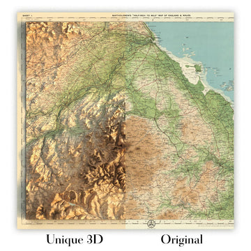
For something truly unique, this map is also available in "Unique 3D", our trademarked process that dramatically transforms the map so that it has a wonderful sense of depth. We combine the original map with detailed topography and elevation data, so that mountains and the terrain really "pop". For more info and examples of 3D maps, check my Unique 3D page.
Sumérjase en los paisajes cargados de historia del Canadá de principios del siglo XX con “Western Canada”, el mapa original de 1922 magistralmente elaborado por John George Bartholomew. Llevando con orgullo su título histórico, este mapa recoge una época crucial en la que las vastas extensiones de Columbia Británica, Alberta, Saskatchewan, Manitoba y el singular distrito federal del río Yukon-Mackenzie iban adquiriendo una definición administrativa y geográfica más precisa. Como segundo tiraje de la edición de 1920, marca una transición significativa en la excelencia cartográfica, al ser el primer mapa del Times Atlas en utilizar el meticuloso enfoque de Bartholomew, una mejora respecto a los mapas de Andree de finales del siglo XIX. Este cambio no solo elevó la precisión del atlas, sino que también señaló una nueva era en la representación visual de los dominios occidentales de Canadá.
La maestría cartográfica de Bartholomew se despliega plenamente mediante el sofisticado uso de tintes hipsométricos y cotas puntuales, que representan con elegancia el dramático relieve de las Montañas Rocosas, las Montañas Costeras y la Meseta Laurentiana. La interacción entre color y contorno da vida a las praderas onduladas, las tierras escarpadas del Escudo y los picos cubiertos de nieve que definen la geografía de la región. Los tintes batimétricos enriquecen aún más la representación, sombreando con precisión científica las profundidades de la bahía de Hudson, el Gran Lago del Esclavo y el lago Winnipeg. Cada detalle, desde los sinuosos ríos Mackenzie y Fraser hasta la intrincada red de rutas marítimas, es testimonio de la dedicación de Bartholomew tanto a la belleza como a la exactitud.
El contexto histórico de este mapa es igualmente cautivador. Creado en una época en que las fronteras occidentales de Canadá evolucionaban con rapidez, recoge la efímera existencia del distrito federal del río Yukon-Mackenzie, una rara organización administrativa que habla de la dinámica gobernanza de los territorios septentrionales. La frontera internacional con Estados Unidos está trazada con nitidez, reflejando tanto las realidades políticas como el legado de la negociación continental. Cabe destacar que la inclusión de notas de corrección de la edición original de 1920 demuestra un compromiso inquebrantable con la información actualizada, garantizando que cada detalle siga siendo una referencia fiable tanto para historiadores como para coleccionistas.
Un recorrido por este mapa revela un paisaje rebosante tanto de maravillas naturales como de asentamientos en expansión. Las ciudades y poblaciones —Vancouver, Calgary, Winnipeg, Regina, Dawson y más— están elegantemente inscritas, con su prominencia actual anticipada por la mano cuidadosa de Bartholomew. Ríos como el Peace, el Athabasca y el Columbia serpentean por el terreno, mientras que los campos auríferos de Cariboo y las cordilleras Selkirk aluden a la rica historia de exploración y descubrimiento de recursos de la región. El Círculo Polar Ártico y las vastas praderas de las Provincias de las Praderas se representan con claridad, subrayando la diversidad y la escala de los entornos del oeste de Canadá.
John George Bartholomew, a menudo aclamado como “el Príncipe de los Cartógrafos”, fue célebre por su innovadora cartografía temática y su incansable búsqueda de la verdad geográfica. Su legado queda indeleblemente plasmado en este mapa, que se erige a la vez como una obra de arte y un documento de relevancia histórica. Para el coleccionista exigente o el historiador apasionado, “Western Canada” es más que un mapa: es una ventana a una época transformadora, una celebración del progreso científico y un tributo al perdurable encanto del oeste canadiense.
Ciudades y poblaciones en este mapa
- Columbia Británica
- Vancouver
- Victoria
- New Westminster
- Prince Rupert
- Kamloops
- Nanaimo
- Alberta
- Calgary
- Edmonton
- Lethbridge
- Medicine Hat
- Red Deer
- Saskatchewan
- Saskatoon
- Regina
- Moose Jaw
- Prince Albert
- Manitoba
- Winnipeg
- Brandon
- Portage la Prairie
- Yukon
- Dawson
- Whitehorse
- Distrito de Mackenzie
- Fort Smith
- Fort Resolution
- Fort Simpson
Características y hitos notables
- Las Montañas Rocosas, representadas de forma destacada con tintes hipsométricos
- El río Mackenzie, mostrado como una vía fluvial principal
- El distrito federal del río Yukon-Mackenzie, una singular región administrativa histórica
- El Escudo Canadiense, indicado mediante un sombreado topográfico distintivo
- La bahía de Hudson, con tintes batimétricos que ilustran la profundidad de las aguas
- El lago Great Slave y el lago Great Bear, importantes lagos del norte
- El río Fraser, un río clave en la Columbia Británica
- El río Columbia, señalado como una vía fluvial significativa
- El lago Winnipeg, un gran lago interior en Manitoba
- La frontera internacional entre Canadá y Estados Unidos, claramente delimitada
- Principales rutas marítimas a través del océano Pacífico, con distancias indicadas
- La frontera de Alaska, que refleja el límite histórico con Estados Unidos
- El río Peace, un río importante del norte de Alberta y la Columbia Británica
- El río Athabasca, otro importante sistema fluvial
- La región de los yacimientos auríferos de Cariboo, históricamente significativa por la fiebre del oro
- Las cordilleras de Selkirk y Purcell, rotuladas en el sureste de la Columbia Británica
- El Círculo Polar Ártico, marcado en la parte norte del mapa
- Las áreas de pradera de las Provincias de las Praderas, mostradas con un sombreado físico distintivo
- La meseta Laurentiana, rotulada en la parte oriental del mapa
- Las Montañas Costeras, que se extienden a lo largo del borde pacífico de la Columbia Británica
Contexto histórico y de diseño
- Título original del mapa: Western Canada (1922), elaborado por John George Bartholomew
- Segunda edición de la edición de 1920; primer mapa del Times Atlas que utiliza la cartografía de Bartholomew, sustituyendo los mapas anteriores de Andree de 1895
- Parte de "The Times Atlas & Gazetteer of the World", una obra de referencia emblemática de la cartografía de principios del siglo XX
- El relieve se representa con tintes hipsométricos y cotas puntuales; la profundidad de las aguas se muestra con tintes batimétricos
- Incluye importantes rutas marítimas con distancias, reflejando la navegación y el comercio de principios del siglo XX
- Presenta la singular disposición administrativa histórica del distrito federal del río Yukon-Mackenzie
- Incluye una página de correcciones de la edición original de 1920, subrayando la exactitud y la información actualizada
- Captura un período de transición en la geografía canadiense, los límites administrativos y la tecnología cartográfica
- Ejemplifica la sofisticación y precisión del diseño cartográfico de principios del siglo XX
- Creado por John George Bartholomew, un reconocido cartógrafo escocés conocido por sus innovaciones en cartografía temática y física
Por favor, revise cuidadosamente las imágenes para asegurarse de que un pueblo o lugar específico aparezca en este mapa. También puede ponerse en contacto con nosotros y pedirnos que revisemos el mapa por usted.
Este mapa luce estupendo en cualquier tamaño, pero siempre recomiendo optar por un tamaño mayor si dispone de espacio. De ese modo podrá apreciar fácilmente todos los detalles.
Este mapa se ve increíble en tamaños de hasta 70in (180cm). Si busca un mapa más grande, por favor póngase en contacto.
La persona en las imágenes del anuncio sostiene la versión de 16x20in (40x50cm) de este mapa.
La quinta imagen del anuncio muestra un ejemplo de mi servicio de personalización de mapas.
Si busca algo ligeramente diferente, consulte mi colección de los mejores mapas antiguos para ver si algo más le llama la atención.
Por favor, contácteme para comprobar si una determinada ubicación, hito o elemento aparece en este mapa.
Esto sería un maravilloso regalo de cumpleaños, Navidad, Día del Padre, despedida del trabajo, aniversario o inauguración de la casa para alguien de las zonas cubiertas por este mapa.
Este mapa está disponible como impresión giclée sobre papel mate de archivo libre de ácido, o puede adquirirse enmarcado. El marco es un bonito y sencillo marco negro que se adapta a la mayoría de los estilos. Por favor, póngase en contacto si desea un color o material de marco diferente. Mis marcos están acristalados con acrílico de calidad museística supertransparente (perspex/acrylite), que es significativamente menos reflectante que el vidrio, más seguro y siempre llegará en perfectas condiciones.
This map is also available as a float framed canvas, sometimes known as a shadow gap framed canvas or canvas floater. The map is printed on artist's cotton canvas and then stretched over a handmade box frame. We then "float" the canvas inside a wooden frame, which is available in a range of colours (black, dark brown, oak, antique gold and white). This is a wonderful way to present a map without glazing in front. See some examples of float framed canvas maps and explore the differences between my different finishes.
For something truly unique, this map is also available in "Unique 3D", our trademarked process that dramatically transforms the map so that it has a wonderful sense of depth. We combine the original map with detailed topography and elevation data, so that mountains and the terrain really "pop". For more info and examples of 3D maps, check my Unique 3D page.
Many of our maps and art prints are chosen as thoughtful gifts for homes, offices, studies and meaningful places.
Choose a framed option for the easiest ready-to-hang gift, or choose an unframed print if the recipient may prefer to select their own frame.
We make orders locally in 23 countries around the world, so gifts can often be produced close to the recipient. This helps them arrive faster, travel more safely, and avoid customs or import duty surprises.
- We can deliver directly to the recipient
- Framed pieces arrive ready to hang
- Unframed prints are carefully packed in a strong protective tube
- Almost every order is made locally, for faster, safer gifting
- 90-day returns give the recipient time to decide
If you are not sure what to choose, please contact us. We can help you pick the right map, size, finish or delivery option.
Para la mayoría de los pedidos, el tiempo de entrega es de aproximadamente 3 días laborables. Los productos personalizados y a medida tardan más, ya que tengo que hacer la personalización y enviártelo para su aprobación, lo cual suele tardar 1 o 2 días.
Tenga en cuenta que los pedidos enmarcados muy grandes suelen tardar más en fabricarse y entregarse.
Si necesitas que tu pedido llegue para una fecha determinada, por favor contáctame antes de hacer el pedido para que podamos encontrar la mejor manera de asegurarnos de que recibas tu pedido a tiempo.
Imprimo y enmarco mapas y obras de arte en 23 países alrededor del mundo. Esto significa que tu pedido se fabricará localmente, lo que reduce el tiempo de entrega y asegura que no se dañe durante el envío. Nunca pagarás aranceles de aduana o impuestos de importación, y pondremos menos CO2 en el aire.
Todos mis mapas y impresiones artísticas están bien empaquetados y enviados en un tubo resistente si no están enmarcados, o rodeados de espuma si están enmarcados.
Intento enviar todos los pedidos dentro de 1 o 2 días después de recibir tu pedido, aunque algunos productos (como mascarillas, tazas y bolsas de tela) pueden tardar más en fabricarse.
Si seleccionas Entrega Exprés al finalizar la compra, priorizaremos tu pedido y lo enviaremos por mensajería de 1 día (Fedex, DHL, UPS, Parcelforce).
La entrega al día siguiente también está disponible en algunos países (EE. UU., Reino Unido, Singapur, EAU), pero por favor intenta hacer tu pedido temprano en el día para que podamos enviarlo a tiempo.
Mi marco estándar es un marco de madera de fresno negro estilo galería. Es simple y tiene un aspecto bastante moderno. Mi marco estándar tiene alrededor de 20 mm (0.8 in) de ancho.
Utilizo acrílico super claro (perspex/acrylite) para el vidrio del marco. Es más ligero y seguro que el vidrio, y se ve mejor, ya que la reflectividad es menor.
Seis colores de marco estándar están disponibles de forma gratuita (negro, marrón oscuro, gris oscuro, roble, blanco y oro antiguo).El enmarcado y montaje/matizado personalizado está disponible si buscas algo diferente.
La mayoría de los mapas, arte e ilustraciones también están disponibles como un lienzo enmarcado. Utilizamos lienzo de algodón mate (no brillante), lo estiramos sobre un marco de madera de caja de origen sostenible, y luego 'flotamos' la pieza dentro de un marco de madera. El resultado final es bastante hermoso, y no hay cristal que se interponga.
Todos los marcos se proporcionan "listos para colgar", con una cuerda o soportes en la parte posterior. Los marcos muy grandes tendrán placas de colgar de alta resistencia y/o un listón de montaje. Si tienes alguna pregunta, por favor ponte en contacto.
Mira algunos ejemplos de mis mapas enmarcados y mapas en lienzo enmarcados.
Alternativamente, también puedo proporcionar mapas antiguos y obras de arte en lienzo, tablero de espuma, papel de algodón y otros materiales.
Si deseas enmarcar tu mapa o obra de arte tú mismo, por favor lee mi guía de tamaños primero.
Mis mapas son reproducciones de mapas originales de altísima calidad.
Obtengo mapas originales y raros de bibliotecas, casas de subastas y colecciones privadas de todo el mundo, los restauro en mi taller de Londres y luego uso tintas e impresoras giclée especializadas para crear hermosos mapas que lucen incluso mejor que el original.
Mis mapas están impresos en papel de archivo mate (no brillante) sin ácido que se siente de muy alta calidad y casi como una tarjeta. En términos técnicos, el peso/grosor del papel es de 10 mil/200 g/m². Es perfecto para enmarcar.
Imprimo con tintas pigmentadas Epson ultrachrome giclée UV resistentes a la decoloración, algunas de las mejores tintas que puedes encontrar.
yo también puedo hacer mapas sobre lienzo, trapo de algodón y otros materiales exóticos.
Obtenga más información sobre The Unique Maps Co..
Personalización de mapas
Si está buscando el regalo perfecto de aniversario o inauguración de la casa, puedo personalizar su mapa para hacerlo verdaderamente único. Por ejemplo, puedo agregar un mensaje corto, resaltar una ubicación importante o agregar el escudo de armas de su familia.
Las opciones son casi infinitas. Por favor mira mi página de personalización de mapas para ver algunos maravillosos ejemplos de lo que es posible.
Para pedir un mapa personalizado, seleccione "personalizar su mapa" antes de agregarlo a su carrito.
Ponerse en contacto si buscas personalizaciones y personalizaciones más complejas.
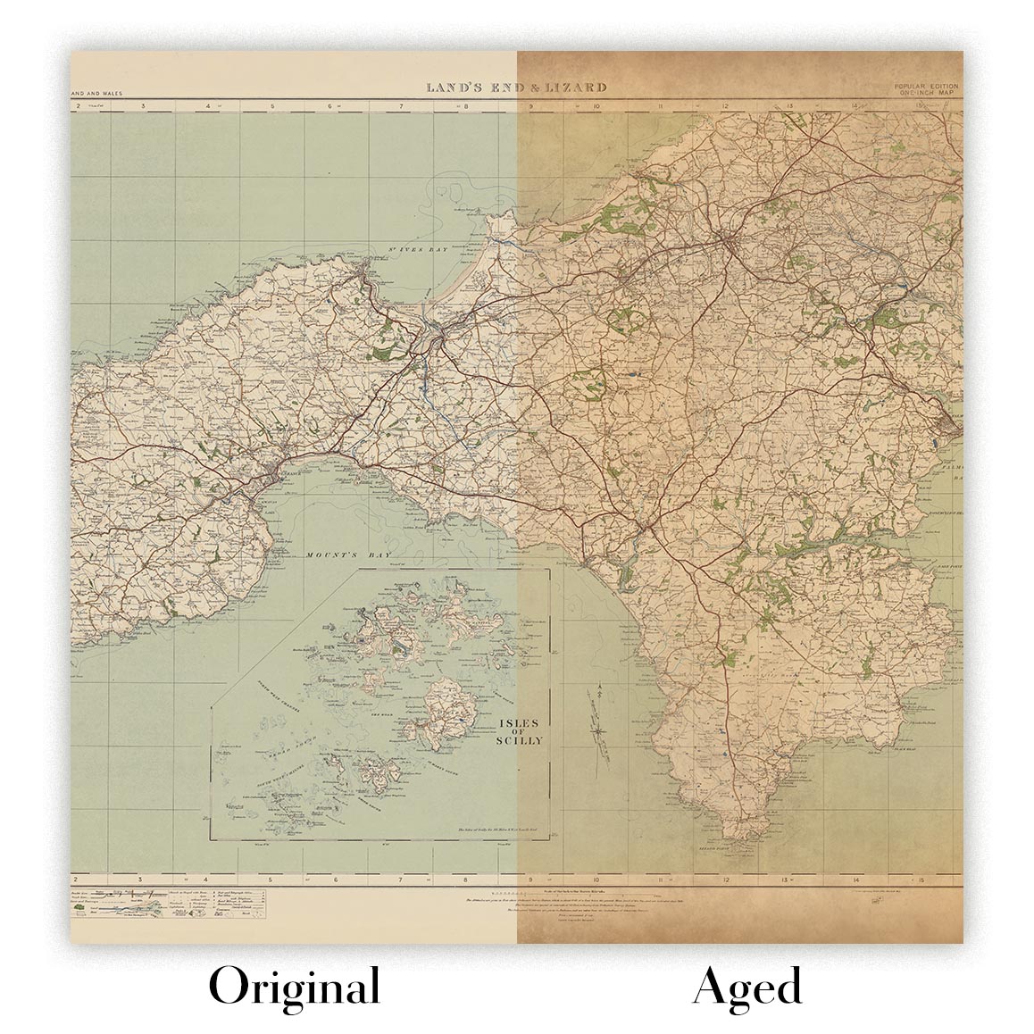
Envejecimiento del mapa
A lo largo de los años, los clientes me han preguntado cientos de veces si podían comprar un mapa que se viera uniforme. más viejo.
Bueno, ahora puedes hacerlo seleccionando Envejecido antes de agregar un mapa a tu carrito.
Todas las fotografías de productos que ve en esta página muestran el mapa en su forma original. Así es como se ve el mapa hoy.
Si selecciona Envejecido, envejeceré su mapa a mano, usando un proceso especial y único desarrollado a través de años de estudiar mapas antiguos, hablar con investigadores para comprender la química del envejecimiento del papel y, por supuesto... ¡mucha práctica!
Si no estás seguro, quédate con el color original del mapa. Si quieres algo un poco más oscuro y más viejo buscando, opte por Envejecido.
Si no estás satisfecho con tu pedido por cualquier motivo, contáctame para un reembolso sin complicaciones. Por favor, consulta nuestra política de devoluciones y reembolsos para más información.
Estoy muy seguro de que te gustará tu mapa o impresión artística restaurada. He estado haciendo esto desde 1984. Soy un vendedor de 5 estrellas en Etsy. He vendido decenas de miles de mapas e impresiones artísticas y tengo más de 5,000 opiniones reales de 5 estrellas.
Utilizo un proceso único para restaurar mapas y obras de arte que consume mucho tiempo y mano de obra. Buscar los mapas e ilustraciones originales puede llevar meses. Utilizo tecnología de última generación y extremadamente cara para escanear y restaurarlos. Como resultado, garantizo que mis mapas e impresiones artísticas son superiores a los demás - por eso puedo ofrecer un reembolso sin complicaciones.
Casi todos mis mapas e impresiones artísticas se ven increíbles en tamaños grandes (200cm, 6.5ft+) y también puedo enmarcarlos y entregártelos a través de un servicio de mensajería especial para tamaños grandes. Contáctame para discutir tus necesidades específicas.
Or try searching for something!


