


Antiguo mapa del Océano Índico de Du Val, 1665: Indias Orientales, viajes holandeses, Australia temprana
La oferta del coleccionista
Elija dos obras elegibles y obtenga un 20 % de descuento en ambas. Elija tres y la de menor precio será gratuita, con un ahorro máximo del 33 %.
Combine y mezcle mapas estándar elegibles y reproducciones de bellas artes. No se requiere código; la oferta se aplica automáticamente al finalizar la compra.
Se incluyen las configuraciones estándar hechas por encargo. Quedan excluidos los tamaños a medida, los diseños personalizados y los trabajos por encargo.
¿Necesita entrega en diferentes direcciones? Contáctenos antes de realizar el pedido.La oferta del coleccionista
Elija dos obras elegibles y obtenga un 20 % de descuento en ambas. Elija tres y la de menor precio será gratuita, con un ahorro máximo del 33 %.
Combine y mezcle mapas estándar elegibles y reproducciones de bellas artes. No se requiere código; la oferta se aplica automáticamente al finalizar la compra.
Se incluyen las configuraciones estándar hechas por encargo. Quedan excluidos los tamaños a medida, los diseños personalizados y los trabajos por encargo.
¿Necesita entrega en diferentes direcciones? Contáctenos antes de realizar el pedido. Diseñado en Londres Hecho en la UE
Diseñado en Londres • Hecho en la UE
Diseñado en Londres Hecho en la UE
Diseñado en Londres • Hecho en la UE

Restaurado a partir del mapa original de 1665 e impreso en calidad museo. Leer la historia detrás de este mapa
Choose your size
Choose your finish


(Más información)
Mensaje de regalo y acabado personalizado

Si deseas agregar un mensaje de regalo, o un acabado (rompecabezas, tablero de aluminio, etc.) que no esté disponible aquí, por favor solicítalo en la "nota del pedido" cuando realices la compra.
Cada pedido es hecho a medida, así que si necesitas que el tamaño se ajuste ligeramente, o que se imprima en un material inusual, háznoslo saber. Hemos realizado miles de pedidos personalizados a lo largo de los años, así que hay (casi) nada que no podamos gestionar.
También puedes contactarnos antes de hacer tu pedido, ¡si lo prefieres!

- Hecho localmente. Entrega segura
- Sin aranceles ni cargos ocultos
- ¿Necesitas ayuda? Llámanos o mensaje por WhatsApp
Own a piece of history
8,000+ five-star reviews


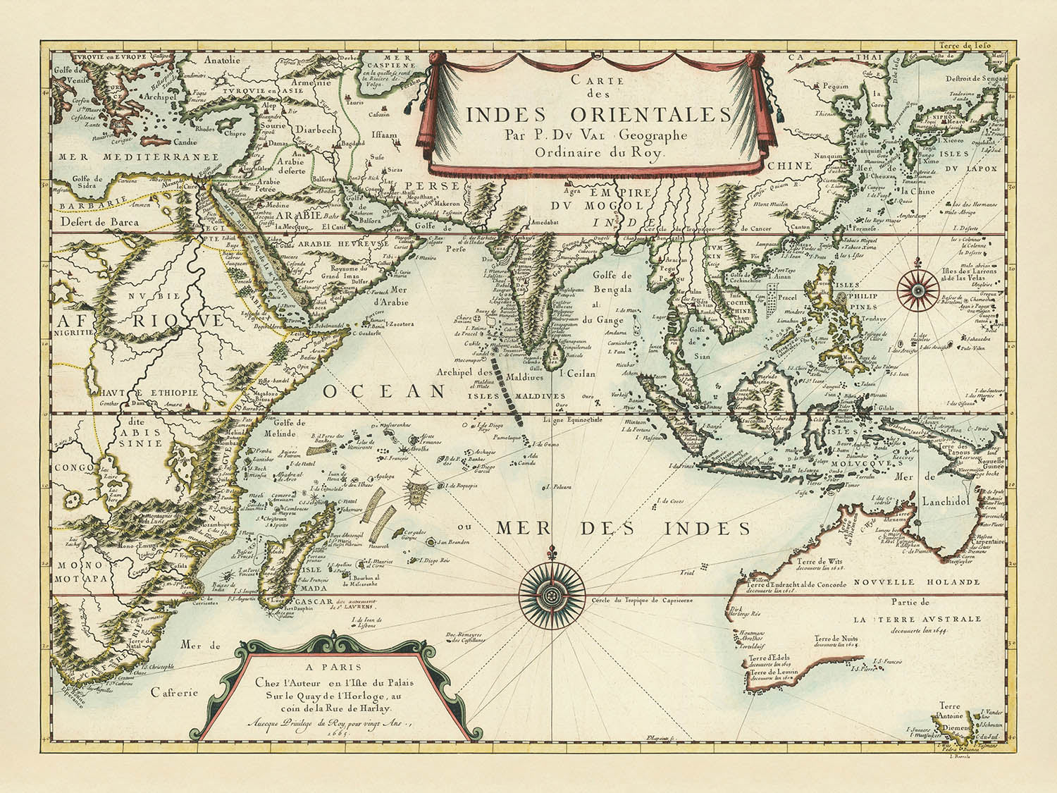
Adéntrese en el fascinante mundo de la exploración del siglo XVII con la obra maestra de Pierre Du Val, Carte des Indes...
Seguir leyendoAdéntrese en el fascinante mundo de la exploración del siglo XVII con la obra maestra de Pierre Du Val, Carte des Indes Orientales . . . 1665. Este extraordinario mapa, realizado por uno de los cartógrafos más estimados de Francia, encapsula el verdadero espíritu de la Era de los Descubrimientos. La investigación minuciosa de Du Val y su acceso a las fuentes holandesas y francesas más recientes se evidencian en cada detalle, ofreciendo una amplia visión del océano Índico y de las tierras que lo rodean en una época en que la curiosidad y la ambición europeas estaban redibujando los límites del mundo conocido.
La escala del mapa es sobrecogedora, extendiéndose desde las costas orientales de África a través del océano Índico hasta las misteriosas tierras de Australia, Japón y el Sudeste Asiático marítimo. Es un registro visual tanto de la geografía política como de la física, que destaca las rutas y los descubrimientos de los exploradores holandeses a lo largo de las costas de Australia y Nueva Guinea. Abundantes anotaciones señalan los primeros encuentros europeos con estas tierras, inmortalizando los viajes del Duyfken, Endracht, Arnhem y otros navíos legendarios. Cada topónimo es testimonio de la búsqueda incesante de conocimiento propia de la época y de la feroz competencia entre las potencias europeas por cartografiar lo desconocido.
La maestría artística de Du Val es inconfundible en los sobrios pero sofisticados adornos del mapa. Elegantes rosas de los vientos guían la mirada del espectador por los mares, mientras que los cartuchos ornamentales —en especial el título drapeado en la parte superior central— aportan una sensación de refinamiento y grandeza. La hidrografía está representada con exquisito cuidado, desde la regularidad “acolchada” de las Maldivas hasta los sinuosos cursos del Ganges y del Nilo. En la parte superior derecha, una Gran Muralla China delicadamente dibujada alude a la apreciación del cartógrafo por las maravillas de Oriente, mientras que las Montagnes de la Lune anclan la imaginación europea del misterioso interior de África.
La importancia histórica del mapa es profunda. Captura un momento decisivo en que la comprensión europea del mundo en general se expandía rápidamente, aunque todavía marcada por lagunas y mitologías. Australia, rotulada como “Novvelle Holande partie de la Terre Australe,” aparece con un contorno sorprendentemente completo para su época, aunque su interior permanece en blanco. Los descubrimientos holandeses quedan registrados con minuciosidad, desde el Houtmans Abrolhos hasta Terre d’Antoine Diemens (Tasmania), junto con referencias al naufragio inglés más temprano, el Trial. Estos detalles no solo iluminan las rutas de intrépidos marinos, sino que también revelan el secreto competitivo y la información ocasionalmente errónea que dieron forma a la cartografía temprana.
Para el coleccionista exigente, la Carte des Indes Orientales de Du Val es más que un mapa: es un vínculo tangible con la edad de oro de la exploración y con el arte en evolución de la cartografía. Su combinación de precisión científica, elegancia artística y anotaciones históricas lo convierten en un artefacto muy apreciado para cualquiera cautivado por las historias de descubrimiento que dieron forma a nuestro mundo moderno. Ya sea exhibido como pieza central o estudiado por su riqueza de detalles, este mapa se erige como testimonio del perdurable encanto de lo desconocido y de la brillantez de quienes se atrevieron a cartografiarlo.
Países y regiones en este mapa
- África (en particular, África Oriental y Meridional)
- Madagascar
- Península Arábiga
- Persia (Irán)
- Imperio mogol (India)
- Ceylán (Sri Lanka)
- China
- Japón
- Corea
- Sudeste Asiático marítimo (incluida la península malaya, Sumatra, Java, Borneo, Filipinas y el archipiélago indonesio)
- Australia (etiquetada como "Novvelle Holande partie de la Terre Australe")
- Nueva Guinea
- Tasmania ("Terre d’Antoine Diemens")
Características destacadas y lugares de interés
- Cartucho decorativo del título en el centro superior, presentado sobre un elegante paño drapeado
- Rosas de los vientos colocadas en varios puntos del océano, que aportan orientación
- Trapezoide ornamental en la esquina inferior izquierda con la dirección y la fecha del cartógrafo
- Representación detallada de la Gran Muralla China en la esquina superior derecha
- Notas históricas claramente rotuladas sobre los viajes y encuentros neerlandeses con Australia, como "Terre d'Arnems," "Terre de Wits," "Houtmans Abrolhos," "Terre d'Edels," "Terre de Leuuin," "Terre d'Antoine Diemens," y "Trial"
- Ríos representados de forma destacada, incluido el Nilo en África (que nace de dos lagos cerca de las Montagnes de la Lune) y el Ganges en Asia del Sur
- Numerosas islas, archipiélagos y bancos de arena, incluidas las Maldivas, representadas con patrones detallados y regulares
- Anotaciones históricas que hacen referencia a navegantes y navíos neerlandeses, incluidos Dirk Hartog, Abel Tasman, Pieter Nuyts y otros
- Rotulación del Imperio mogol en Asia del Sur
- Rotulación de las rutas de exploración y los descubrimientos de la VOC (Compañía Neerlandesa de las Indias Orientales) a lo largo de la costa australiana
Contexto histórico y de diseño
- Creado por Pierre Du Val, un destacado cartógrafo francés conocido por sus mapas detallados y elegantemente decorados
- Publicado por primera vez en 1665, con una segunda edición en 1677
- Refleja el conocimiento geográfico europeo y la exploración de finales del siglo XVII, en particular la exploración marítima neerlandesa y los encuentros con Australia
- Incorpora información de cartas y mapas de la Compañía Neerlandesa de las Indias Orientales (VOC) y de Melchisédech Thévenot, especialmente para Asia Oriental
- Elegantemente decorado con adornos sobrios pero sofisticados, incluidas rosas de los vientos, cartuchos ornamentales y un paño decorativo para el título
- Los temas incluyen la exploración marítima, el primer contacto europeo con Australia, el conocimiento geográfico de Asia y África, la hidrografía y el arte cartográfico
- Captura un momento decisivo en el que la comprensión europea del mundo en general se estaba expandiendo rápidamente, aunque aún marcada por lagunas y mitologías
Por favor, comprueba bien las imágenes para asegurarte de que una ciudad o lugar específico aparece en este mapa. También puedes ponerte en contacto con nosotros y pedirnos que revisemos el mapa por ti.
Este mapa se ve estupendo en todos los tamaños, pero siempre recomiendo elegir un tamaño mayor si tienes espacio. Así podrás distinguir fácilmente todos los detalles.
Este mapa luce increíble en tamaños de hasta 90in (230cm). Si buscas un mapa más grande, por favor ponte en contacto.
El modelo en las imágenes del anuncio sostiene la versión de 18x24in (45x60cm) de este mapa.
La quinta imagen del anuncio muestra un ejemplo de mi servicio de personalización de mapas.
Si buscas algo ligeramente diferente, echa un vistazo a mi colección de los mejores mapas antiguos para ver si algo más llama tu atención.
Por favor contáctame para comprobar si una cierta ubicación, hito o característica aparece en este mapa.
Sería un regalo maravilloso de cumpleaños, Navidad, Día del Padre, despedida del trabajo, aniversario o inauguración de casa para alguien de las zonas cubiertas por este mapa.
Este mapa está disponible como impresión giclée en papel mate de archivo libre de ácido, o puede adquirirse enmarcado. El marco es un marco negro, sencillo y elegante, que se adapta a la mayoría de las estéticas. Póngase en contacto si desea un color o material de marco diferente. Mis marcos están acristalados con acrílico de calidad museística de máxima transparencia (perspex/acrylite), que refleja mucho menos que el vidrio, es más seguro y siempre llegará en perfectas condiciones.
This map is also available as a float framed canvas, sometimes known as a shadow gap framed canvas or canvas floater. The map is printed on artist's cotton canvas and then stretched over a handmade box frame. We then "float" the canvas inside a wooden frame, which is available in a range of colours (black, dark brown, oak, antique gold and white). This is a wonderful way to present a map without glazing in front. See some examples of float framed canvas maps and explore the differences between my different finishes.
For something truly unique, this map is also available in "Unique 3D", our trademarked process that dramatically transforms the map so that it has a wonderful sense of depth. We combine the original map with detailed topography and elevation data, so that mountains and the terrain really "pop". For more info and examples of 3D maps, check my Unique 3D page.
Adéntrese en el fascinante mundo de la exploración del siglo XVII con la obra maestra de Pierre Du Val, Carte des Indes Orientales . . . 1665. Este extraordinario mapa, realizado por uno de los cartógrafos más estimados de Francia, encapsula el verdadero espíritu de la Era de los Descubrimientos. La investigación minuciosa de Du Val y su acceso a las fuentes holandesas y francesas más recientes se evidencian en cada detalle, ofreciendo una amplia visión del océano Índico y de las tierras que lo rodean en una época en que la curiosidad y la ambición europeas estaban redibujando los límites del mundo conocido.
La escala del mapa es sobrecogedora, extendiéndose desde las costas orientales de África a través del océano Índico hasta las misteriosas tierras de Australia, Japón y el Sudeste Asiático marítimo. Es un registro visual tanto de la geografía política como de la física, que destaca las rutas y los descubrimientos de los exploradores holandeses a lo largo de las costas de Australia y Nueva Guinea. Abundantes anotaciones señalan los primeros encuentros europeos con estas tierras, inmortalizando los viajes del Duyfken, Endracht, Arnhem y otros navíos legendarios. Cada topónimo es testimonio de la búsqueda incesante de conocimiento propia de la época y de la feroz competencia entre las potencias europeas por cartografiar lo desconocido.
La maestría artística de Du Val es inconfundible en los sobrios pero sofisticados adornos del mapa. Elegantes rosas de los vientos guían la mirada del espectador por los mares, mientras que los cartuchos ornamentales —en especial el título drapeado en la parte superior central— aportan una sensación de refinamiento y grandeza. La hidrografía está representada con exquisito cuidado, desde la regularidad “acolchada” de las Maldivas hasta los sinuosos cursos del Ganges y del Nilo. En la parte superior derecha, una Gran Muralla China delicadamente dibujada alude a la apreciación del cartógrafo por las maravillas de Oriente, mientras que las Montagnes de la Lune anclan la imaginación europea del misterioso interior de África.
La importancia histórica del mapa es profunda. Captura un momento decisivo en que la comprensión europea del mundo en general se expandía rápidamente, aunque todavía marcada por lagunas y mitologías. Australia, rotulada como “Novvelle Holande partie de la Terre Australe,” aparece con un contorno sorprendentemente completo para su época, aunque su interior permanece en blanco. Los descubrimientos holandeses quedan registrados con minuciosidad, desde el Houtmans Abrolhos hasta Terre d’Antoine Diemens (Tasmania), junto con referencias al naufragio inglés más temprano, el Trial. Estos detalles no solo iluminan las rutas de intrépidos marinos, sino que también revelan el secreto competitivo y la información ocasionalmente errónea que dieron forma a la cartografía temprana.
Para el coleccionista exigente, la Carte des Indes Orientales de Du Val es más que un mapa: es un vínculo tangible con la edad de oro de la exploración y con el arte en evolución de la cartografía. Su combinación de precisión científica, elegancia artística y anotaciones históricas lo convierten en un artefacto muy apreciado para cualquiera cautivado por las historias de descubrimiento que dieron forma a nuestro mundo moderno. Ya sea exhibido como pieza central o estudiado por su riqueza de detalles, este mapa se erige como testimonio del perdurable encanto de lo desconocido y de la brillantez de quienes se atrevieron a cartografiarlo.
Países y regiones en este mapa
- África (en particular, África Oriental y Meridional)
- Madagascar
- Península Arábiga
- Persia (Irán)
- Imperio mogol (India)
- Ceylán (Sri Lanka)
- China
- Japón
- Corea
- Sudeste Asiático marítimo (incluida la península malaya, Sumatra, Java, Borneo, Filipinas y el archipiélago indonesio)
- Australia (etiquetada como "Novvelle Holande partie de la Terre Australe")
- Nueva Guinea
- Tasmania ("Terre d’Antoine Diemens")
Características destacadas y lugares de interés
- Cartucho decorativo del título en el centro superior, presentado sobre un elegante paño drapeado
- Rosas de los vientos colocadas en varios puntos del océano, que aportan orientación
- Trapezoide ornamental en la esquina inferior izquierda con la dirección y la fecha del cartógrafo
- Representación detallada de la Gran Muralla China en la esquina superior derecha
- Notas históricas claramente rotuladas sobre los viajes y encuentros neerlandeses con Australia, como "Terre d'Arnems," "Terre de Wits," "Houtmans Abrolhos," "Terre d'Edels," "Terre de Leuuin," "Terre d'Antoine Diemens," y "Trial"
- Ríos representados de forma destacada, incluido el Nilo en África (que nace de dos lagos cerca de las Montagnes de la Lune) y el Ganges en Asia del Sur
- Numerosas islas, archipiélagos y bancos de arena, incluidas las Maldivas, representadas con patrones detallados y regulares
- Anotaciones históricas que hacen referencia a navegantes y navíos neerlandeses, incluidos Dirk Hartog, Abel Tasman, Pieter Nuyts y otros
- Rotulación del Imperio mogol en Asia del Sur
- Rotulación de las rutas de exploración y los descubrimientos de la VOC (Compañía Neerlandesa de las Indias Orientales) a lo largo de la costa australiana
Contexto histórico y de diseño
- Creado por Pierre Du Val, un destacado cartógrafo francés conocido por sus mapas detallados y elegantemente decorados
- Publicado por primera vez en 1665, con una segunda edición en 1677
- Refleja el conocimiento geográfico europeo y la exploración de finales del siglo XVII, en particular la exploración marítima neerlandesa y los encuentros con Australia
- Incorpora información de cartas y mapas de la Compañía Neerlandesa de las Indias Orientales (VOC) y de Melchisédech Thévenot, especialmente para Asia Oriental
- Elegantemente decorado con adornos sobrios pero sofisticados, incluidas rosas de los vientos, cartuchos ornamentales y un paño decorativo para el título
- Los temas incluyen la exploración marítima, el primer contacto europeo con Australia, el conocimiento geográfico de Asia y África, la hidrografía y el arte cartográfico
- Captura un momento decisivo en el que la comprensión europea del mundo en general se estaba expandiendo rápidamente, aunque aún marcada por lagunas y mitologías
Por favor, comprueba bien las imágenes para asegurarte de que una ciudad o lugar específico aparece en este mapa. También puedes ponerte en contacto con nosotros y pedirnos que revisemos el mapa por ti.
Este mapa se ve estupendo en todos los tamaños, pero siempre recomiendo elegir un tamaño mayor si tienes espacio. Así podrás distinguir fácilmente todos los detalles.
Este mapa luce increíble en tamaños de hasta 90in (230cm). Si buscas un mapa más grande, por favor ponte en contacto.
El modelo en las imágenes del anuncio sostiene la versión de 18x24in (45x60cm) de este mapa.
La quinta imagen del anuncio muestra un ejemplo de mi servicio de personalización de mapas.
Si buscas algo ligeramente diferente, echa un vistazo a mi colección de los mejores mapas antiguos para ver si algo más llama tu atención.
Por favor contáctame para comprobar si una cierta ubicación, hito o característica aparece en este mapa.
Sería un regalo maravilloso de cumpleaños, Navidad, Día del Padre, despedida del trabajo, aniversario o inauguración de casa para alguien de las zonas cubiertas por este mapa.
Este mapa está disponible como impresión giclée en papel mate de archivo libre de ácido, o puede adquirirse enmarcado. El marco es un marco negro, sencillo y elegante, que se adapta a la mayoría de las estéticas. Póngase en contacto si desea un color o material de marco diferente. Mis marcos están acristalados con acrílico de calidad museística de máxima transparencia (perspex/acrylite), que refleja mucho menos que el vidrio, es más seguro y siempre llegará en perfectas condiciones.
This map is also available as a float framed canvas, sometimes known as a shadow gap framed canvas or canvas floater. The map is printed on artist's cotton canvas and then stretched over a handmade box frame. We then "float" the canvas inside a wooden frame, which is available in a range of colours (black, dark brown, oak, antique gold and white). This is a wonderful way to present a map without glazing in front. See some examples of float framed canvas maps and explore the differences between my different finishes.
For something truly unique, this map is also available in "Unique 3D", our trademarked process that dramatically transforms the map so that it has a wonderful sense of depth. We combine the original map with detailed topography and elevation data, so that mountains and the terrain really "pop". For more info and examples of 3D maps, check my Unique 3D page.
Many of our maps and art prints are chosen as thoughtful gifts for homes, offices, studies and meaningful places.
Choose a framed option for the easiest ready-to-hang gift, or choose an unframed print if the recipient may prefer to select their own frame.
We make orders locally in 23 countries around the world, so gifts can often be produced close to the recipient. This helps them arrive faster, travel more safely, and avoid customs or import duty surprises.
- We can deliver directly to the recipient
- Framed pieces arrive ready to hang
- Unframed prints are carefully packed in a strong protective tube
- Almost every order is made locally, for faster, safer gifting
- 90-day returns give the recipient time to decide
If you are not sure what to choose, please contact us. We can help you pick the right map, size, finish or delivery option.
Para la mayoría de los pedidos, el tiempo de entrega es de aproximadamente 3 días laborables. Los productos personalizados y a medida tardan más, ya que tengo que hacer la personalización y enviártelo para su aprobación, lo cual suele tardar 1 o 2 días.
Tenga en cuenta que los pedidos enmarcados muy grandes suelen tardar más en fabricarse y entregarse.
Si necesitas que tu pedido llegue para una fecha determinada, por favor contáctame antes de hacer el pedido para que podamos encontrar la mejor manera de asegurarnos de que recibas tu pedido a tiempo.
Imprimo y enmarco mapas y obras de arte en 23 países alrededor del mundo. Esto significa que tu pedido se fabricará localmente, lo que reduce el tiempo de entrega y asegura que no se dañe durante el envío. Nunca pagarás aranceles de aduana o impuestos de importación, y pondremos menos CO2 en el aire.
Todos mis mapas y impresiones artísticas están bien empaquetados y enviados en un tubo resistente si no están enmarcados, o rodeados de espuma si están enmarcados.
Intento enviar todos los pedidos dentro de 1 o 2 días después de recibir tu pedido, aunque algunos productos (como mascarillas, tazas y bolsas de tela) pueden tardar más en fabricarse.
Si seleccionas Entrega Exprés al finalizar la compra, priorizaremos tu pedido y lo enviaremos por mensajería de 1 día (Fedex, DHL, UPS, Parcelforce).
La entrega al día siguiente también está disponible en algunos países (EE. UU., Reino Unido, Singapur, EAU), pero por favor intenta hacer tu pedido temprano en el día para que podamos enviarlo a tiempo.
Mi marco estándar es un marco de madera de fresno negro estilo galería. Es simple y tiene un aspecto bastante moderno. Mi marco estándar tiene alrededor de 20 mm (0.8 in) de ancho.
Utilizo acrílico super claro (perspex/acrylite) para el vidrio del marco. Es más ligero y seguro que el vidrio, y se ve mejor, ya que la reflectividad es menor.
Seis colores de marco estándar están disponibles de forma gratuita (negro, marrón oscuro, gris oscuro, roble, blanco y oro antiguo).El enmarcado y montaje/matizado personalizado está disponible si buscas algo diferente.
La mayoría de los mapas, arte e ilustraciones también están disponibles como un lienzo enmarcado. Utilizamos lienzo de algodón mate (no brillante), lo estiramos sobre un marco de madera de caja de origen sostenible, y luego 'flotamos' la pieza dentro de un marco de madera. El resultado final es bastante hermoso, y no hay cristal que se interponga.
Todos los marcos se proporcionan "listos para colgar", con una cuerda o soportes en la parte posterior. Los marcos muy grandes tendrán placas de colgar de alta resistencia y/o un listón de montaje. Si tienes alguna pregunta, por favor ponte en contacto.
Mira algunos ejemplos de mis mapas enmarcados y mapas en lienzo enmarcados.
Alternativamente, también puedo proporcionar mapas antiguos y obras de arte en lienzo, tablero de espuma, papel de algodón y otros materiales.
Si deseas enmarcar tu mapa o obra de arte tú mismo, por favor lee mi guía de tamaños primero.
Mis mapas son reproducciones de mapas originales de altísima calidad.
Obtengo mapas originales y raros de bibliotecas, casas de subastas y colecciones privadas de todo el mundo, los restauro en mi taller de Londres y luego uso tintas e impresoras giclée especializadas para crear hermosos mapas que lucen incluso mejor que el original.
Mis mapas están impresos en papel de archivo mate (no brillante) sin ácido que se siente de muy alta calidad y casi como una tarjeta. En términos técnicos, el peso/grosor del papel es de 10 mil/200 g/m². Es perfecto para enmarcar.
Imprimo con tintas pigmentadas Epson ultrachrome giclée UV resistentes a la decoloración, algunas de las mejores tintas que puedes encontrar.
yo también puedo hacer mapas sobre lienzo, trapo de algodón y otros materiales exóticos.
Obtenga más información sobre The Unique Maps Co..
Personalización de mapas
Si está buscando el regalo perfecto de aniversario o inauguración de la casa, puedo personalizar su mapa para hacerlo verdaderamente único. Por ejemplo, puedo agregar un mensaje corto, resaltar una ubicación importante o agregar el escudo de armas de su familia.
Las opciones son casi infinitas. Por favor mira mi página de personalización de mapas para ver algunos maravillosos ejemplos de lo que es posible.
Para pedir un mapa personalizado, seleccione "personalizar su mapa" antes de agregarlo a su carrito.
Ponerse en contacto si buscas personalizaciones y personalizaciones más complejas.
Envejecimiento del mapa
A lo largo de los años, los clientes me han preguntado cientos de veces si podían comprar un mapa que se viera uniforme. más viejo.
Bueno, ahora puedes hacerlo seleccionando Envejecido antes de agregar un mapa a tu carrito.
Todas las fotografías de productos que ve en esta página muestran el mapa en su forma original. Así es como se ve el mapa hoy.
Si selecciona Envejecido, envejeceré su mapa a mano, usando un proceso especial y único desarrollado a través de años de estudiar mapas antiguos, hablar con investigadores para comprender la química del envejecimiento del papel y, por supuesto... ¡mucha práctica!
Si no estás seguro, quédate con el color original del mapa. Si quieres algo un poco más oscuro y más viejo buscando, opte por Envejecido.
Si no estás satisfecho con tu pedido por cualquier motivo, contáctame para un reembolso sin complicaciones. Por favor, consulta nuestra política de devoluciones y reembolsos para más información.
Estoy muy seguro de que te gustará tu mapa o impresión artística restaurada. He estado haciendo esto desde 1984. Soy un vendedor de 5 estrellas en Etsy. He vendido decenas de miles de mapas e impresiones artísticas y tengo más de 5,000 opiniones reales de 5 estrellas.
Utilizo un proceso único para restaurar mapas y obras de arte que consume mucho tiempo y mano de obra. Buscar los mapas e ilustraciones originales puede llevar meses. Utilizo tecnología de última generación y extremadamente cara para escanear y restaurarlos. Como resultado, garantizo que mis mapas e impresiones artísticas son superiores a los demás - por eso puedo ofrecer un reembolso sin complicaciones.
Casi todos mis mapas e impresiones artísticas se ven increíbles en tamaños grandes (200cm, 6.5ft+) y también puedo enmarcarlos y entregártelos a través de un servicio de mensajería especial para tamaños grandes. Contáctame para discutir tus necesidades específicas.
Or try searching for something!


