


Mapa antiguo de Ontario y Quebec de Bartholomew, 1922: Ciudad de Quebec, St. John’s, bahía de Hudson, montes Torngat, golfo de San Lorenzo
La oferta del coleccionista
Elija dos obras elegibles y obtenga un 20 % de descuento en ambas. Elija tres y la de menor precio será gratuita, con un ahorro máximo del 33 %.
Combine y mezcle mapas estándar elegibles y reproducciones de bellas artes. No se requiere código; la oferta se aplica automáticamente al finalizar la compra.
Se incluyen las configuraciones estándar hechas por encargo. Quedan excluidos los tamaños a medida, los diseños personalizados y los trabajos por encargo.
¿Necesita entrega en diferentes direcciones? Contáctenos antes de realizar el pedido.La oferta del coleccionista
Elija dos obras elegibles y obtenga un 20 % de descuento en ambas. Elija tres y la de menor precio será gratuita, con un ahorro máximo del 33 %.
Combine y mezcle mapas estándar elegibles y reproducciones de bellas artes. No se requiere código; la oferta se aplica automáticamente al finalizar la compra.
Se incluyen las configuraciones estándar hechas por encargo. Quedan excluidos los tamaños a medida, los diseños personalizados y los trabajos por encargo.
¿Necesita entrega en diferentes direcciones? Contáctenos antes de realizar el pedido. Diseñado en Londres Hecho en la UE
Diseñado en Londres • Hecho en la UE
Diseñado en Londres Hecho en la UE
Diseñado en Londres • Hecho en la UE

Restaurado a partir del mapa original de 1922 e impreso en calidad museo. Leer la historia detrás de este mapa
Choose your size
Choose your finish


(Más información)
Mensaje de regalo y acabado personalizado

Si deseas agregar un mensaje de regalo, o un acabado (rompecabezas, tablero de aluminio, etc.) que no esté disponible aquí, por favor solicítalo en la "nota del pedido" cuando realices la compra.
Cada pedido es hecho a medida, así que si necesitas que el tamaño se ajuste ligeramente, o que se imprima en un material inusual, háznoslo saber. Hemos realizado miles de pedidos personalizados a lo largo de los años, así que hay (casi) nada que no podamos gestionar.
También puedes contactarnos antes de hacer tu pedido, ¡si lo prefieres!

- Hecho localmente. Entrega segura
- Sin aranceles ni cargos ocultos
- ¿Necesitas ayuda? Llámanos o mensaje por WhatsApp
Own a piece of history
8,000+ five-star reviews


Adéntrese en la elegancia cartográfica de principios del siglo XX con “North-eastern Canada”, una obra maestra creada por el estimado J.G. Bartholomew...
Seguir leyendoAdéntrese en la elegancia cartográfica de principios del siglo XX con “North-eastern Canada”, una obra maestra creada por el estimado J.G. Bartholomew en 1922. Conservando su título original, este mapa ofrece una representación amplia pero minuciosa de una de las regiones más célebres y agrestes de Canadá. Desde la vasta extensión de la bahía de Hudson hasta las escarpadas costas de Labrador y las relucientes aguas del golfo de San Lorenzo, la meticulosa maestría de Bartholomew da vida a la dramática interacción entre tierra y mar. Cada tinte hipsométrico y cada tono batimétrico cuenta una historia de grandeza geológica, capturando las elevadas montañas Torngat, la inmensidad de la bahía de Ungava y el delicado trazado de los ríos que han modelado esta tierra durante milenios.
J.G. Bartholomew, una figura destacada en el mundo de la cartografía, revolucionó la elaboración de atlas con su compromiso tanto con la exactitud científica como con la belleza visual. Este mapa marca un momento decisivo en la historia cartográfica, al ser la primera vez que los mapas de Bartholomew aparecieron en The Times Atlas & Gazetteer of the World. Su uso innovador de gradaciones cromáticas para la altitud y la profundidad, junto con un trazado preciso y un etiquetado claro, estableció un nuevo estándar para el diseño de mapas. La inclusión de rutas marítimas con distancias calculadas meticulosamente subraya el doble propósito del mapa como obra de arte y como herramienta práctica para la navegación y la exploración.
La detallada representación del noreste de Canadá abarca las provincias de Quebec y Newfoundland and Labrador, en una época en que la región aún estaba siendo explorada y desarrollada activamente. Los límites políticos están nítidamente delineados, reflejando las divisiones administrativas de la época, mientras que el mundo natural se plasma con igual esmero. La isla Anticosti, Belle Isle y el célebre estrecho de Belle Isle aparecen todos presentes, con posiciones vitales para los marinos que navegan las a menudo traicioneras aguas del Atlántico Norte. La maestría artística del mapa se ve acompañada por su exactitud, además reforzada por una página de correcciones de la edición de 1920, lo que garantiza la información más actualizada para sus usuarios contemporáneos.
Una sensación de grandeza impregna las características físicas del mapa, desde las cumbres nevadas de las montañas Torngat hasta los profundos azules del mar de Labrador. El vasto lago Mistassini y el sinuoso río Churchill son solo dos de las muchas vías fluviales que surcan este paisaje indómito. La cuidadosa aplicación por parte de Bartholomew de tintes hipsométricos y batimétricos transforma el mapa en un tableau viviente, invitando al observador a seguir los contornos de la tierra e imaginar los viajes de exploradores, comerciantes y pueblos indígenas que han llamado a esta región su hogar.
Entre los asentamientos que salpican esta vasta extensión salvaje, ciudades como Quebec City, St. John's y Saguenay (Chicoutimi) se alzan como faros del esfuerzo y la resiliencia humanos. Su ubicación en el mapa es testimonio de la relación perdurable entre las personas y el lugar en esta parte del mundo. Tanto si le atraen los célebres ríos, las espectaculares costas o el rico tapiz de historia cultural y natural, “North-eastern Canada” de J.G. Bartholomew es una celebración de lo conocido y lo desconocido: una invitación de lujo a explorar la belleza atemporal de la frontera nororiental de Canadá.
Ciudades y pueblos en este mapa
- Quebec
- Quebec City
- Saguenay (Chicoutimi)
- Sept-Îles
- Baie-Comeau
- Newfoundland and Labrador
- St. John's
- Corner Brook
- Labrador City
- Happy Valley-Goose Bay
- Otras regiones (si son visibles)
- Kuujjuaq (Quebec, región de Nunavik)
Características destacadas y lugares de interés
- Bahía de Hudson (gran mar interior en el noreste de Canadá)
- Mar de Labrador (masa de agua al este de Labrador)
- Golfo de San Lorenzo (gran golfo en la desembocadura del río San Lorenzo)
- Estrecho de Belle Isle (estrecho angosto entre Terranova y Labrador)
- Bahía de Ungava (gran bahía en el norte de Quebec)
- Lago Mistassini (el lago natural más grande de Quebec)
- Montes Torngat (cordillera en el norte de Labrador)
- Isla Anticosti (gran isla en la desembocadura del río San Lorenzo)
- Belle Isle (isla en la entrada del estrecho de Belle Isle)
- Rutas marítimas con distancias (líneas marcadas a través de las áreas marítimas)
- Tintes batimétricos que muestran las profundidades oceánicas
- Tintes hipsométricos y cotas puntuales que indican la elevación
- Fronteras provinciales (especialmente Quebec y Terranova/Labrador)
- Numerosos ríos (p. ej., río San Lorenzo, río Churchill)
- Costa detallada con bahías, ensenadas y penínsulas
Contexto histórico y de diseño
- Creado por J.G. (John George) Bartholomew en 1922, un reconocido cartógrafo que revolucionó la elaboración de atlas.
- Incluido en la segunda edición de la edición de 1920 de The Times Atlas & Gazetteer of the World, marcando el primer uso de los mapas de Bartholomew en esta serie.
- El relieve está ilustrado mediante tintes hipsométricos (sombreado en color para indicar la elevación) y cotas puntuales; se utilizan tintes batimétricos para mostrar las profundidades del agua.
- Destaca por representar rutas marítimas con distancias, lo que facilita la navegación y la exploración geográfica.
- Incluye una página de correcciones de la edición de 1920, que proporciona información actualizada y precisa.
- Representa un cambio fundamental en la cartografía de atlas, introduciendo el influyente estilo y la precisión de Bartholomew.
- Hace hincapié tanto en la geografía natural (relieve, hidrografía) como en la geografía humana (divisiones políticas, rutas marítimas).
- Se caracteriza por un etiquetado claro, gradaciones de color para la elevación y la profundidad, y un trazo preciso típico del trabajo de Bartholomew.
- Creado durante un periodo de creciente interés por la cartografía mundial precisa y la navegación, poco después de la Primera Guerra Mundial.
Please double check the images to make sure that a specific town or place is shown on this map. You can also get in touch and ask us to check the map for you.
Este mapa luce magnífico en cualquier tamaño, pero siempre recomiendo optar por un tamaño mayor si dispone de espacio. Así podrá distinguir fácilmente todos los detalles.
Este mapa se ve increíble en tamaños de hasta 70in (180cm). Si busca un mapa de mayor tamaño, por favor contáctenos.
El modelo en las imágenes del anuncio sostiene la versión de 16x20in (40x50cm) de este mapa.
La quinta imagen del anuncio muestra un ejemplo de mi servicio de personalización de mapas.
Si busca algo ligeramente diferente, eche un vistazo a mi colección de los mejores mapas antiguos para ver si algo más le llama la atención.
Por favor, contácteme para comprobar si una determinada ubicación, lugar de interés o característica aparece en este mapa.
Esto sería un maravilloso regalo de cumpleaños, Navidad, Día del Padre, despedida laboral, aniversario o inauguración de casa para alguien de las áreas cubiertas por este mapa.
Este mapa está disponible como impresión giclée en papel mate de archivo libre de ácido, o puede adquirirlo enmarcado. El marco es un marco negro, sencillo y elegante, que se adapta a la mayoría de las estéticas. Por favor, póngase en contacto si desea un color o material de marco diferente. Mis marcos llevan un acristalamiento de acrílico de calidad museo, ultraclaro (perspex/acrylite), que es considerablemente menos reflectante que el vidrio, más seguro y siempre llegará en perfectas condiciones.
This map is also available as a float framed canvas, sometimes known as a shadow gap framed canvas or canvas floater. The map is printed on artist's cotton canvas and then stretched over a handmade box frame. We then "float" the canvas inside a wooden frame, which is available in a range of colours (black, dark brown, oak, antique gold and white). This is a wonderful way to present a map without glazing in front. See some examples of float framed canvas maps and explore the differences between my different finishes.
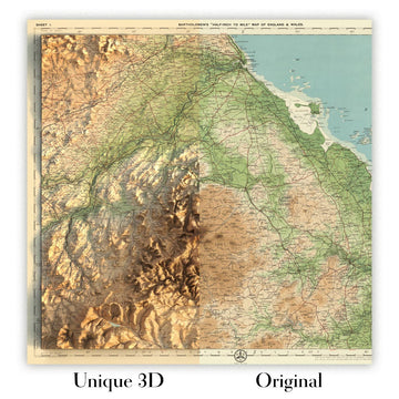
For something truly unique, this map is also available in "Unique 3D", our trademarked process that dramatically transforms the map so that it has a wonderful sense of depth. We combine the original map with detailed topography and elevation data, so that mountains and the terrain really "pop". For more info and examples of 3D maps, check my Unique 3D page.
Adéntrese en la elegancia cartográfica de principios del siglo XX con “North-eastern Canada”, una obra maestra creada por el estimado J.G. Bartholomew en 1922. Conservando su título original, este mapa ofrece una representación amplia pero minuciosa de una de las regiones más célebres y agrestes de Canadá. Desde la vasta extensión de la bahía de Hudson hasta las escarpadas costas de Labrador y las relucientes aguas del golfo de San Lorenzo, la meticulosa maestría de Bartholomew da vida a la dramática interacción entre tierra y mar. Cada tinte hipsométrico y cada tono batimétrico cuenta una historia de grandeza geológica, capturando las elevadas montañas Torngat, la inmensidad de la bahía de Ungava y el delicado trazado de los ríos que han modelado esta tierra durante milenios.
J.G. Bartholomew, una figura destacada en el mundo de la cartografía, revolucionó la elaboración de atlas con su compromiso tanto con la exactitud científica como con la belleza visual. Este mapa marca un momento decisivo en la historia cartográfica, al ser la primera vez que los mapas de Bartholomew aparecieron en The Times Atlas & Gazetteer of the World. Su uso innovador de gradaciones cromáticas para la altitud y la profundidad, junto con un trazado preciso y un etiquetado claro, estableció un nuevo estándar para el diseño de mapas. La inclusión de rutas marítimas con distancias calculadas meticulosamente subraya el doble propósito del mapa como obra de arte y como herramienta práctica para la navegación y la exploración.
La detallada representación del noreste de Canadá abarca las provincias de Quebec y Newfoundland and Labrador, en una época en que la región aún estaba siendo explorada y desarrollada activamente. Los límites políticos están nítidamente delineados, reflejando las divisiones administrativas de la época, mientras que el mundo natural se plasma con igual esmero. La isla Anticosti, Belle Isle y el célebre estrecho de Belle Isle aparecen todos presentes, con posiciones vitales para los marinos que navegan las a menudo traicioneras aguas del Atlántico Norte. La maestría artística del mapa se ve acompañada por su exactitud, además reforzada por una página de correcciones de la edición de 1920, lo que garantiza la información más actualizada para sus usuarios contemporáneos.
Una sensación de grandeza impregna las características físicas del mapa, desde las cumbres nevadas de las montañas Torngat hasta los profundos azules del mar de Labrador. El vasto lago Mistassini y el sinuoso río Churchill son solo dos de las muchas vías fluviales que surcan este paisaje indómito. La cuidadosa aplicación por parte de Bartholomew de tintes hipsométricos y batimétricos transforma el mapa en un tableau viviente, invitando al observador a seguir los contornos de la tierra e imaginar los viajes de exploradores, comerciantes y pueblos indígenas que han llamado a esta región su hogar.
Entre los asentamientos que salpican esta vasta extensión salvaje, ciudades como Quebec City, St. John's y Saguenay (Chicoutimi) se alzan como faros del esfuerzo y la resiliencia humanos. Su ubicación en el mapa es testimonio de la relación perdurable entre las personas y el lugar en esta parte del mundo. Tanto si le atraen los célebres ríos, las espectaculares costas o el rico tapiz de historia cultural y natural, “North-eastern Canada” de J.G. Bartholomew es una celebración de lo conocido y lo desconocido: una invitación de lujo a explorar la belleza atemporal de la frontera nororiental de Canadá.
Ciudades y pueblos en este mapa
- Quebec
- Quebec City
- Saguenay (Chicoutimi)
- Sept-Îles
- Baie-Comeau
- Newfoundland and Labrador
- St. John's
- Corner Brook
- Labrador City
- Happy Valley-Goose Bay
- Otras regiones (si son visibles)
- Kuujjuaq (Quebec, región de Nunavik)
Características destacadas y lugares de interés
- Bahía de Hudson (gran mar interior en el noreste de Canadá)
- Mar de Labrador (masa de agua al este de Labrador)
- Golfo de San Lorenzo (gran golfo en la desembocadura del río San Lorenzo)
- Estrecho de Belle Isle (estrecho angosto entre Terranova y Labrador)
- Bahía de Ungava (gran bahía en el norte de Quebec)
- Lago Mistassini (el lago natural más grande de Quebec)
- Montes Torngat (cordillera en el norte de Labrador)
- Isla Anticosti (gran isla en la desembocadura del río San Lorenzo)
- Belle Isle (isla en la entrada del estrecho de Belle Isle)
- Rutas marítimas con distancias (líneas marcadas a través de las áreas marítimas)
- Tintes batimétricos que muestran las profundidades oceánicas
- Tintes hipsométricos y cotas puntuales que indican la elevación
- Fronteras provinciales (especialmente Quebec y Terranova/Labrador)
- Numerosos ríos (p. ej., río San Lorenzo, río Churchill)
- Costa detallada con bahías, ensenadas y penínsulas
Contexto histórico y de diseño
- Creado por J.G. (John George) Bartholomew en 1922, un reconocido cartógrafo que revolucionó la elaboración de atlas.
- Incluido en la segunda edición de la edición de 1920 de The Times Atlas & Gazetteer of the World, marcando el primer uso de los mapas de Bartholomew en esta serie.
- El relieve está ilustrado mediante tintes hipsométricos (sombreado en color para indicar la elevación) y cotas puntuales; se utilizan tintes batimétricos para mostrar las profundidades del agua.
- Destaca por representar rutas marítimas con distancias, lo que facilita la navegación y la exploración geográfica.
- Incluye una página de correcciones de la edición de 1920, que proporciona información actualizada y precisa.
- Representa un cambio fundamental en la cartografía de atlas, introduciendo el influyente estilo y la precisión de Bartholomew.
- Hace hincapié tanto en la geografía natural (relieve, hidrografía) como en la geografía humana (divisiones políticas, rutas marítimas).
- Se caracteriza por un etiquetado claro, gradaciones de color para la elevación y la profundidad, y un trazo preciso típico del trabajo de Bartholomew.
- Creado durante un periodo de creciente interés por la cartografía mundial precisa y la navegación, poco después de la Primera Guerra Mundial.
Please double check the images to make sure that a specific town or place is shown on this map. You can also get in touch and ask us to check the map for you.
Este mapa luce magnífico en cualquier tamaño, pero siempre recomiendo optar por un tamaño mayor si dispone de espacio. Así podrá distinguir fácilmente todos los detalles.
Este mapa se ve increíble en tamaños de hasta 70in (180cm). Si busca un mapa de mayor tamaño, por favor contáctenos.
El modelo en las imágenes del anuncio sostiene la versión de 16x20in (40x50cm) de este mapa.
La quinta imagen del anuncio muestra un ejemplo de mi servicio de personalización de mapas.
Si busca algo ligeramente diferente, eche un vistazo a mi colección de los mejores mapas antiguos para ver si algo más le llama la atención.
Por favor, contácteme para comprobar si una determinada ubicación, lugar de interés o característica aparece en este mapa.
Esto sería un maravilloso regalo de cumpleaños, Navidad, Día del Padre, despedida laboral, aniversario o inauguración de casa para alguien de las áreas cubiertas por este mapa.
Este mapa está disponible como impresión giclée en papel mate de archivo libre de ácido, o puede adquirirlo enmarcado. El marco es un marco negro, sencillo y elegante, que se adapta a la mayoría de las estéticas. Por favor, póngase en contacto si desea un color o material de marco diferente. Mis marcos llevan un acristalamiento de acrílico de calidad museo, ultraclaro (perspex/acrylite), que es considerablemente menos reflectante que el vidrio, más seguro y siempre llegará en perfectas condiciones.
This map is also available as a float framed canvas, sometimes known as a shadow gap framed canvas or canvas floater. The map is printed on artist's cotton canvas and then stretched over a handmade box frame. We then "float" the canvas inside a wooden frame, which is available in a range of colours (black, dark brown, oak, antique gold and white). This is a wonderful way to present a map without glazing in front. See some examples of float framed canvas maps and explore the differences between my different finishes.
For something truly unique, this map is also available in "Unique 3D", our trademarked process that dramatically transforms the map so that it has a wonderful sense of depth. We combine the original map with detailed topography and elevation data, so that mountains and the terrain really "pop". For more info and examples of 3D maps, check my Unique 3D page.
Many of our maps and art prints are chosen as thoughtful gifts for homes, offices, studies and meaningful places.
Choose a framed option for the easiest ready-to-hang gift, or choose an unframed print if the recipient may prefer to select their own frame.
We make orders locally in 23 countries around the world, so gifts can often be produced close to the recipient. This helps them arrive faster, travel more safely, and avoid customs or import duty surprises.
- We can deliver directly to the recipient
- Framed pieces arrive ready to hang
- Unframed prints are carefully packed in a strong protective tube
- Almost every order is made locally, for faster, safer gifting
- 90-day returns give the recipient time to decide
If you are not sure what to choose, please contact us. We can help you pick the right map, size, finish or delivery option.
Para la mayoría de los pedidos, el tiempo de entrega es de aproximadamente 3 días laborables. Los productos personalizados y a medida tardan más, ya que tengo que hacer la personalización y enviártelo para su aprobación, lo cual suele tardar 1 o 2 días.
Tenga en cuenta que los pedidos enmarcados muy grandes suelen tardar más en fabricarse y entregarse.
Si necesitas que tu pedido llegue para una fecha determinada, por favor contáctame antes de hacer el pedido para que podamos encontrar la mejor manera de asegurarnos de que recibas tu pedido a tiempo.
Imprimo y enmarco mapas y obras de arte en 23 países alrededor del mundo. Esto significa que tu pedido se fabricará localmente, lo que reduce el tiempo de entrega y asegura que no se dañe durante el envío. Nunca pagarás aranceles de aduana o impuestos de importación, y pondremos menos CO2 en el aire.
Todos mis mapas y impresiones artísticas están bien empaquetados y enviados en un tubo resistente si no están enmarcados, o rodeados de espuma si están enmarcados.
Intento enviar todos los pedidos dentro de 1 o 2 días después de recibir tu pedido, aunque algunos productos (como mascarillas, tazas y bolsas de tela) pueden tardar más en fabricarse.
Si seleccionas Entrega Exprés al finalizar la compra, priorizaremos tu pedido y lo enviaremos por mensajería de 1 día (Fedex, DHL, UPS, Parcelforce).
La entrega al día siguiente también está disponible en algunos países (EE. UU., Reino Unido, Singapur, EAU), pero por favor intenta hacer tu pedido temprano en el día para que podamos enviarlo a tiempo.
Mi marco estándar es un marco de madera de fresno negro estilo galería. Es simple y tiene un aspecto bastante moderno. Mi marco estándar tiene alrededor de 20 mm (0.8 in) de ancho.
Utilizo acrílico super claro (perspex/acrylite) para el vidrio del marco. Es más ligero y seguro que el vidrio, y se ve mejor, ya que la reflectividad es menor.
Seis colores de marco estándar están disponibles de forma gratuita (negro, marrón oscuro, gris oscuro, roble, blanco y oro antiguo).El enmarcado y montaje/matizado personalizado está disponible si buscas algo diferente.
La mayoría de los mapas, arte e ilustraciones también están disponibles como un lienzo enmarcado. Utilizamos lienzo de algodón mate (no brillante), lo estiramos sobre un marco de madera de caja de origen sostenible, y luego 'flotamos' la pieza dentro de un marco de madera. El resultado final es bastante hermoso, y no hay cristal que se interponga.
Todos los marcos se proporcionan "listos para colgar", con una cuerda o soportes en la parte posterior. Los marcos muy grandes tendrán placas de colgar de alta resistencia y/o un listón de montaje. Si tienes alguna pregunta, por favor ponte en contacto.
Mira algunos ejemplos de mis mapas enmarcados y mapas en lienzo enmarcados.
Alternativamente, también puedo proporcionar mapas antiguos y obras de arte en lienzo, tablero de espuma, papel de algodón y otros materiales.
Si deseas enmarcar tu mapa o obra de arte tú mismo, por favor lee mi guía de tamaños primero.
Mis mapas son reproducciones de mapas originales de altísima calidad.
Obtengo mapas originales y raros de bibliotecas, casas de subastas y colecciones privadas de todo el mundo, los restauro en mi taller de Londres y luego uso tintas e impresoras giclée especializadas para crear hermosos mapas que lucen incluso mejor que el original.
Mis mapas están impresos en papel de archivo mate (no brillante) sin ácido que se siente de muy alta calidad y casi como una tarjeta. En términos técnicos, el peso/grosor del papel es de 10 mil/200 g/m². Es perfecto para enmarcar.
Imprimo con tintas pigmentadas Epson ultrachrome giclée UV resistentes a la decoloración, algunas de las mejores tintas que puedes encontrar.
yo también puedo hacer mapas sobre lienzo, trapo de algodón y otros materiales exóticos.
Obtenga más información sobre The Unique Maps Co..
Personalización de mapas
Si está buscando el regalo perfecto de aniversario o inauguración de la casa, puedo personalizar su mapa para hacerlo verdaderamente único. Por ejemplo, puedo agregar un mensaje corto, resaltar una ubicación importante o agregar el escudo de armas de su familia.
Las opciones son casi infinitas. Por favor mira mi página de personalización de mapas para ver algunos maravillosos ejemplos de lo que es posible.
Para pedir un mapa personalizado, seleccione "personalizar su mapa" antes de agregarlo a su carrito.
Ponerse en contacto si buscas personalizaciones y personalizaciones más complejas.
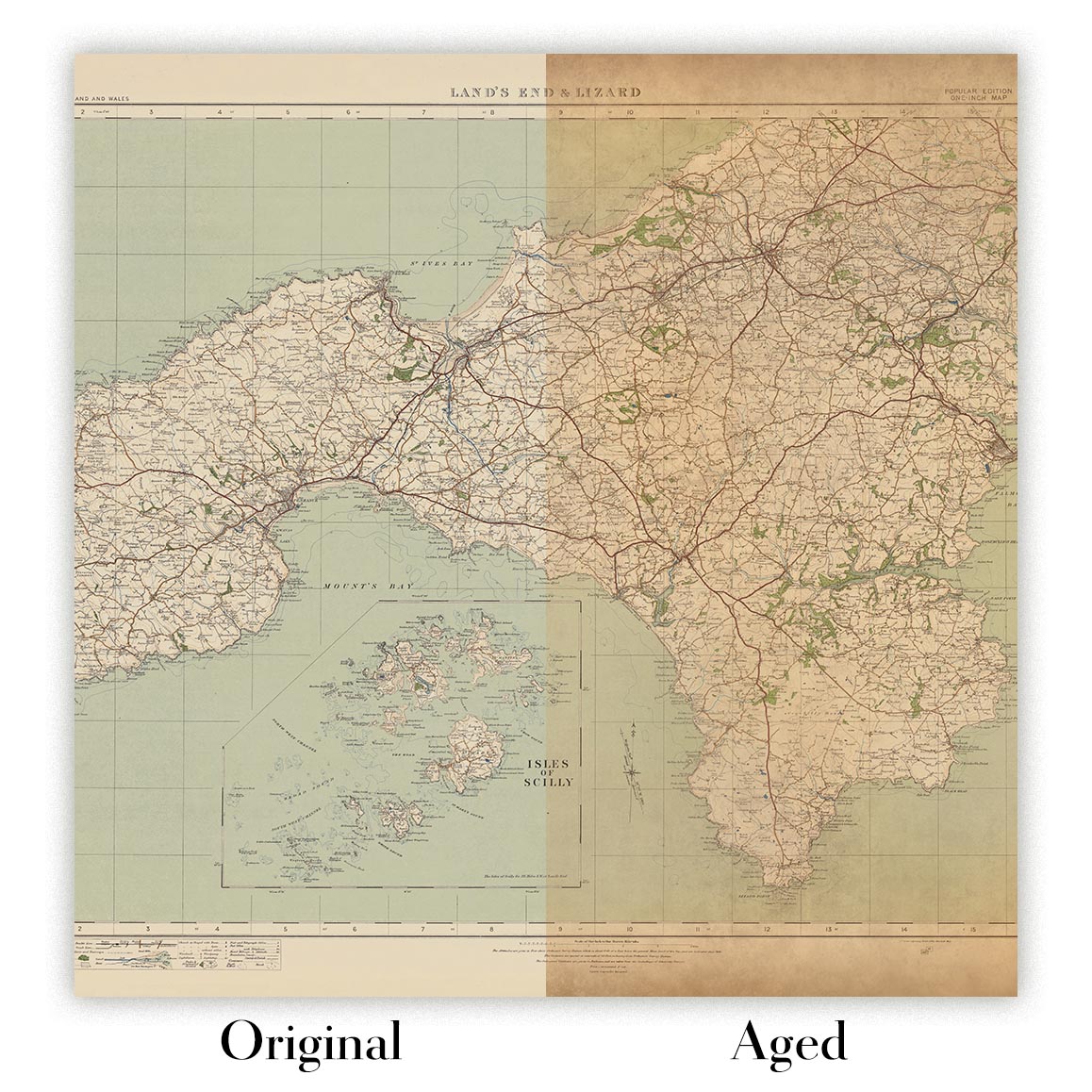
Envejecimiento del mapa
A lo largo de los años, los clientes me han preguntado cientos de veces si podían comprar un mapa que se viera uniforme. más viejo.
Bueno, ahora puedes hacerlo seleccionando Envejecido antes de agregar un mapa a tu carrito.
Todas las fotografías de productos que ve en esta página muestran el mapa en su forma original. Así es como se ve el mapa hoy.
Si selecciona Envejecido, envejeceré su mapa a mano, usando un proceso especial y único desarrollado a través de años de estudiar mapas antiguos, hablar con investigadores para comprender la química del envejecimiento del papel y, por supuesto... ¡mucha práctica!
Si no estás seguro, quédate con el color original del mapa. Si quieres algo un poco más oscuro y más viejo buscando, opte por Envejecido.
Si no estás satisfecho con tu pedido por cualquier motivo, contáctame para un reembolso sin complicaciones. Por favor, consulta nuestra política de devoluciones y reembolsos para más información.
Estoy muy seguro de que te gustará tu mapa o impresión artística restaurada. He estado haciendo esto desde 1984. Soy un vendedor de 5 estrellas en Etsy. He vendido decenas de miles de mapas e impresiones artísticas y tengo más de 5,000 opiniones reales de 5 estrellas.
Utilizo un proceso único para restaurar mapas y obras de arte que consume mucho tiempo y mano de obra. Buscar los mapas e ilustraciones originales puede llevar meses. Utilizo tecnología de última generación y extremadamente cara para escanear y restaurarlos. Como resultado, garantizo que mis mapas e impresiones artísticas son superiores a los demás - por eso puedo ofrecer un reembolso sin complicaciones.
Casi todos mis mapas e impresiones artísticas se ven increíbles en tamaños grandes (200cm, 6.5ft+) y también puedo enmarcarlos y entregártelos a través de un servicio de mensajería especial para tamaños grandes. Contáctame para discutir tus necesidades específicas.
Or try searching for something!


