


Antiguo mapa del condado de Lancaster, PA, de Schmuckle, 1949: ríos Ephrata, Lititz, Susquehanna y Conestoga, comunidades amish
La oferta del coleccionista
Elija dos obras elegibles y obtenga un 20 % de descuento en ambas. Elija tres y la de menor precio será gratuita, con un ahorro máximo del 33 %.
Combine y mezcle mapas estándar elegibles y reproducciones de bellas artes. No se requiere código; la oferta se aplica automáticamente al finalizar la compra.
Se incluyen las configuraciones estándar hechas por encargo. Quedan excluidos los tamaños a medida, los diseños personalizados y los trabajos por encargo.
¿Necesita entrega en diferentes direcciones? Contáctenos antes de realizar el pedido.La oferta del coleccionista
Elija dos obras elegibles y obtenga un 20 % de descuento en ambas. Elija tres y la de menor precio será gratuita, con un ahorro máximo del 33 %.
Combine y mezcle mapas estándar elegibles y reproducciones de bellas artes. No se requiere código; la oferta se aplica automáticamente al finalizar la compra.
Se incluyen las configuraciones estándar hechas por encargo. Quedan excluidos los tamaños a medida, los diseños personalizados y los trabajos por encargo.
¿Necesita entrega en diferentes direcciones? Contáctenos antes de realizar el pedido. Diseñado en Londres Hecho en la UE
Diseñado en Londres • Hecho en la UE
Diseñado en Londres Hecho en la UE
Diseñado en Londres • Hecho en la UE

Restaurado a partir del mapa original de 1949 e impreso en calidad museo. Leer la historia detrás de este mapa
Choose your size
Choose your finish


(Más información)
Mensaje de regalo y acabado personalizado

Si deseas agregar un mensaje de regalo, o un acabado (rompecabezas, tablero de aluminio, etc.) que no esté disponible aquí, por favor solicítalo en la "nota del pedido" cuando realices la compra.
Cada pedido es hecho a medida, así que si necesitas que el tamaño se ajuste ligeramente, o que se imprima en un material inusual, háznoslo saber. Hemos realizado miles de pedidos personalizados a lo largo de los años, así que hay (casi) nada que no podamos gestionar.
También puedes contactarnos antes de hacer tu pedido, ¡si lo prefieres!

- Hecho localmente. Entrega segura
- Sin aranceles ni cargos ocultos
- ¿Necesitas ayuda? Llámanos o mensaje por WhatsApp
Own a piece of history
8,000+ five-star reviews


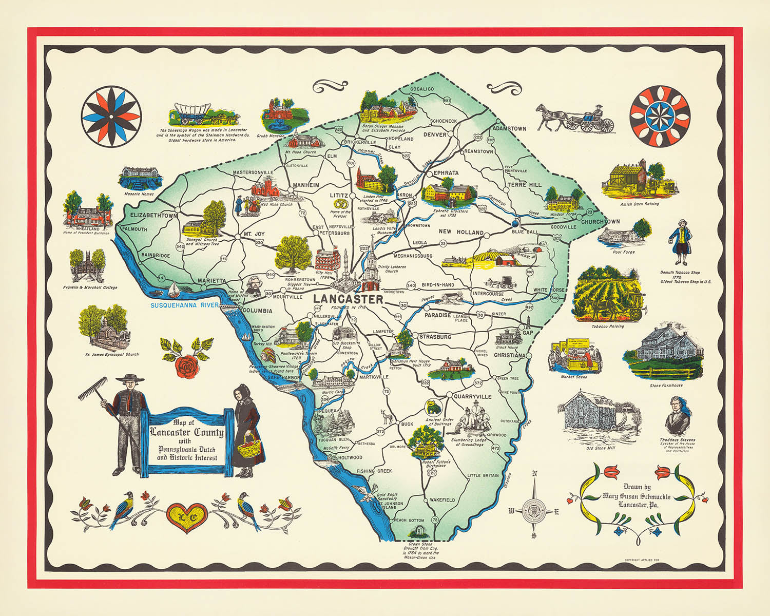
El “Map of Lancaster County with Pennsylvania Dutch and Historic Interest,” creado en 1949 por Mary Susan Schmuckle, es un cautivador mapa...
Seguir leyendoEl “Map of Lancaster County with Pennsylvania Dutch and Historic Interest,” creado en 1949 por Mary Susan Schmuckle, es un cautivador mapa pictórico y temático de la ciudad que sumerge al espectador en el rico tapiz cultural del condado de Lancaster, Pensilvania. El arte y la atención al detalle de Schmuckle dan vida al singular patrimonio Pennsylvania Dutch, con ilustraciones dibujadas a mano que celebran los hitos históricos, las raíces agrícolas y las vibrantes comunidades de la región. Este mapa es más que una herramienta de orientación: es un libro visual de historias que captura el espíritu del condado de Lancaster en un momento crucial de su historia, justo después de la Segunda Guerra Mundial.
La obra de Mary Susan Schmuckle destaca por su perspectiva profundamente local. Como artista residente, Schmuckle impregnó su creación con un conocimiento íntimo de las ciudades y boroughs de Lancaster, incluidos lugares destacados como Lancaster, Ephrata, Lititz, Strasburg y Columbia. Sus ilustraciones no son meramente decorativas; son ventanas a la vida cotidiana y a las tradiciones de los Pennsylvania Dutch, con icónicos hex signs, graneros y figuras con vestimenta tradicional. Estos elementos convierten el mapa en un objeto raro y valioso tanto para coleccionistas como para historiadores.
El diseño del mapa es a la vez funcional y encantador, con una clara delimitación de los límites del condado de Lancaster y una cartela decorativa que enmarca elegantemente el título y el nombre de la creadora. El uso por parte de Schmuckle de una rosa de los vientos y de detalladas representaciones pictóricas de los ríos Susquehanna y Conestoga aporta orientación y sentido de lugar. Los propios ríos son fundamentales para la identidad del condado, al modelar su paisaje y servir como arterias vitales para el comercio y la cultura a lo largo de su historia.
Entre las características más destacadas figuran las cuidadosamente elaboradas ilustraciones de puentes cubiertos, molinos, iglesias históricas y meeting houses, cada una testimonio del legado perdurable de las comunidades de Lancaster. La presencia de asentamientos amish y menonitas se representa con sensibilidad, con escenas de granjas y de la vida agrícola que subrayan la conexión continua del condado con su pasado rural. Estos relatos visuales invitan al espectador a explorar los barrios y lugares emblemáticos de Lancaster, descubriendo las historias inscritas en sus campos y poblaciones.
La rareza de este mapa solo aumenta su atractivo. Con copias conocidas conservadas únicamente en la Biblioteca del Congreso y en los Archivos del Estado de Pensilvania, la creación de 1949 de Schmuckle es un tesoro muy codiciado por conocedores del arte cartográfico y de la historia de Estados Unidos. Se erige como testimonio del encanto perdurable y la importancia de los mapas de ciudades, ofreciendo una visión del corazón del condado de Lancaster y de la experiencia Pennsylvania Dutch a través de los ojos de una talentosa cartógrafa local.
Streets and roads on this map
- Columbia Pike
- Fruitville Pike
- Harrisburg Pike
- King Street
- Lincoln Highway
- Lititz Pike
- Manor Avenue
- Marietta Avenue
- New Holland Pike
- Oregon Pike
- Queen Street
- Strasburg Pike
Notable Features & Landmarks
- Illustrations of Pennsylvania Dutch cultural elements (e.g., hex signs, barns, and traditional dress)
- Pictorial depictions of historic buildings and landmarks throughout Lancaster County
- Towns and boroughs such as Lancaster, Ephrata, Lititz, Strasburg, and Columbia
- The Susquehanna River, prominently shown along the western border of the county
- The Conestoga River, winding through the county
Contexto histórico y de diseño
- Nombre del mapa: Map of Lancaster County with Pennsylvania Dutch and Historic Interest
- Cartógrafa: Mary Susan Schmuckle, una artista local que creó el mapa en 1949
- Región representada: Condado de Lancaster, Pensilvania, Estados Unidos
- Tipo: mapa temático urbano y pictórico
- Temas: cultura Pennsylvania Dutch e interés histórico, con ilustraciones pictóricas que destacan rasgos culturales, históricos y locales
- Diseño/estilo: pictórico y temático, con ilustraciones dibujadas a mano y elementos decorativos que enfatizan el patrimonio y los hitos locales
- Rareza: OCLC no localiza ejemplares; las copias conocidas se conservan en la Biblioteca del Congreso (copia de depósito por derechos de autor) y en los Archivos del Estado de Pensilvania
- Importancia histórica: ofrece una representación visual del condado de Lancaster a mediados del siglo XX, centrada en su herencia Pennsylvania Dutch y en sitios destacados, y sirve como artefacto cultural de la posguerra
Por favor, compruebe detenidamente las imágenes para asegurarse de que en este mapa aparece una ciudad o lugar concreto. También puede ponerse en contacto con nosotros y pedirnos que revisemos el mapa por usted.
Este mapa luce estupendo en cualquier tamaño, pero siempre recomiendo optar por un tamaño mayor si dispone de espacio. Así podrá distinguir fácilmente todos los detalles.
Este mapa se ve increíble en tamaños de hasta 100in (250cm). Si busca un mapa más grande, por favor póngase en contacto.
El modelo en las imágenes del anuncio sostiene la versión de 16x20in (40x50cm) de este mapa.
La quinta imagen del anuncio muestra un ejemplo de mi servicio de personalización de mapas.
Si busca algo un poco diferente, explore mi colección de los mejores mapas antiguos para ver si hay algo más que le llame la atención.
Por favor, contácteme para comprobar si una ubicación, hito o elemento concreto aparece en este mapa.
Sería un regalo maravilloso de cumpleaños, Navidad, Día del Padre, despedida del trabajo, aniversario o inauguración de casa para alguien de las zonas cubiertas por este mapa.
Este mapa está disponible como impresión giclée en papel mate de archivo libre de ácido, o puede comprarlo enmarcado. El marco es un elegante y sencillo marco negro que combina con la mayoría de estilos. Por favor, póngase en contacto si desea un color o material de marco diferente. Mis marcos están acristalados con acrílico de calidad museística supertransparente (perspex/acrylite), que es significativamente menos reflectante que el vidrio, más seguro, y siempre llegará en perfectas condiciones.
This map is also available as a float framed canvas, sometimes known as a shadow gap framed canvas or canvas floater. The map is printed on artist's cotton canvas and then stretched over a handmade box frame. We then "float" the canvas inside a wooden frame, which is available in a range of colours (black, dark brown, oak, antique gold and white). This is a wonderful way to present a map without glazing in front. See some examples of float framed canvas maps and explore the differences between my different finishes.
For something truly unique, this map is also available in "Unique 3D", our trademarked process that dramatically transforms the map so that it has a wonderful sense of depth. We combine the original map with detailed topography and elevation data, so that mountains and the terrain really "pop". For more info and examples of 3D maps, check my Unique 3D page.
El “Map of Lancaster County with Pennsylvania Dutch and Historic Interest,” creado en 1949 por Mary Susan Schmuckle, es un cautivador mapa pictórico y temático de la ciudad que sumerge al espectador en el rico tapiz cultural del condado de Lancaster, Pensilvania. El arte y la atención al detalle de Schmuckle dan vida al singular patrimonio Pennsylvania Dutch, con ilustraciones dibujadas a mano que celebran los hitos históricos, las raíces agrícolas y las vibrantes comunidades de la región. Este mapa es más que una herramienta de orientación: es un libro visual de historias que captura el espíritu del condado de Lancaster en un momento crucial de su historia, justo después de la Segunda Guerra Mundial.
La obra de Mary Susan Schmuckle destaca por su perspectiva profundamente local. Como artista residente, Schmuckle impregnó su creación con un conocimiento íntimo de las ciudades y boroughs de Lancaster, incluidos lugares destacados como Lancaster, Ephrata, Lititz, Strasburg y Columbia. Sus ilustraciones no son meramente decorativas; son ventanas a la vida cotidiana y a las tradiciones de los Pennsylvania Dutch, con icónicos hex signs, graneros y figuras con vestimenta tradicional. Estos elementos convierten el mapa en un objeto raro y valioso tanto para coleccionistas como para historiadores.
El diseño del mapa es a la vez funcional y encantador, con una clara delimitación de los límites del condado de Lancaster y una cartela decorativa que enmarca elegantemente el título y el nombre de la creadora. El uso por parte de Schmuckle de una rosa de los vientos y de detalladas representaciones pictóricas de los ríos Susquehanna y Conestoga aporta orientación y sentido de lugar. Los propios ríos son fundamentales para la identidad del condado, al modelar su paisaje y servir como arterias vitales para el comercio y la cultura a lo largo de su historia.
Entre las características más destacadas figuran las cuidadosamente elaboradas ilustraciones de puentes cubiertos, molinos, iglesias históricas y meeting houses, cada una testimonio del legado perdurable de las comunidades de Lancaster. La presencia de asentamientos amish y menonitas se representa con sensibilidad, con escenas de granjas y de la vida agrícola que subrayan la conexión continua del condado con su pasado rural. Estos relatos visuales invitan al espectador a explorar los barrios y lugares emblemáticos de Lancaster, descubriendo las historias inscritas en sus campos y poblaciones.
La rareza de este mapa solo aumenta su atractivo. Con copias conocidas conservadas únicamente en la Biblioteca del Congreso y en los Archivos del Estado de Pensilvania, la creación de 1949 de Schmuckle es un tesoro muy codiciado por conocedores del arte cartográfico y de la historia de Estados Unidos. Se erige como testimonio del encanto perdurable y la importancia de los mapas de ciudades, ofreciendo una visión del corazón del condado de Lancaster y de la experiencia Pennsylvania Dutch a través de los ojos de una talentosa cartógrafa local.
Streets and roads on this map
- Columbia Pike
- Fruitville Pike
- Harrisburg Pike
- King Street
- Lincoln Highway
- Lititz Pike
- Manor Avenue
- Marietta Avenue
- New Holland Pike
- Oregon Pike
- Queen Street
- Strasburg Pike
Notable Features & Landmarks
- Illustrations of Pennsylvania Dutch cultural elements (e.g., hex signs, barns, and traditional dress)
- Pictorial depictions of historic buildings and landmarks throughout Lancaster County
- Towns and boroughs such as Lancaster, Ephrata, Lititz, Strasburg, and Columbia
- The Susquehanna River, prominently shown along the western border of the county
- The Conestoga River, winding through the county
Contexto histórico y de diseño
- Nombre del mapa: Map of Lancaster County with Pennsylvania Dutch and Historic Interest
- Cartógrafa: Mary Susan Schmuckle, una artista local que creó el mapa en 1949
- Región representada: Condado de Lancaster, Pensilvania, Estados Unidos
- Tipo: mapa temático urbano y pictórico
- Temas: cultura Pennsylvania Dutch e interés histórico, con ilustraciones pictóricas que destacan rasgos culturales, históricos y locales
- Diseño/estilo: pictórico y temático, con ilustraciones dibujadas a mano y elementos decorativos que enfatizan el patrimonio y los hitos locales
- Rareza: OCLC no localiza ejemplares; las copias conocidas se conservan en la Biblioteca del Congreso (copia de depósito por derechos de autor) y en los Archivos del Estado de Pensilvania
- Importancia histórica: ofrece una representación visual del condado de Lancaster a mediados del siglo XX, centrada en su herencia Pennsylvania Dutch y en sitios destacados, y sirve como artefacto cultural de la posguerra
Por favor, compruebe detenidamente las imágenes para asegurarse de que en este mapa aparece una ciudad o lugar concreto. También puede ponerse en contacto con nosotros y pedirnos que revisemos el mapa por usted.
Este mapa luce estupendo en cualquier tamaño, pero siempre recomiendo optar por un tamaño mayor si dispone de espacio. Así podrá distinguir fácilmente todos los detalles.
Este mapa se ve increíble en tamaños de hasta 100in (250cm). Si busca un mapa más grande, por favor póngase en contacto.
El modelo en las imágenes del anuncio sostiene la versión de 16x20in (40x50cm) de este mapa.
La quinta imagen del anuncio muestra un ejemplo de mi servicio de personalización de mapas.
Si busca algo un poco diferente, explore mi colección de los mejores mapas antiguos para ver si hay algo más que le llame la atención.
Por favor, contácteme para comprobar si una ubicación, hito o elemento concreto aparece en este mapa.
Sería un regalo maravilloso de cumpleaños, Navidad, Día del Padre, despedida del trabajo, aniversario o inauguración de casa para alguien de las zonas cubiertas por este mapa.
Este mapa está disponible como impresión giclée en papel mate de archivo libre de ácido, o puede comprarlo enmarcado. El marco es un elegante y sencillo marco negro que combina con la mayoría de estilos. Por favor, póngase en contacto si desea un color o material de marco diferente. Mis marcos están acristalados con acrílico de calidad museística supertransparente (perspex/acrylite), que es significativamente menos reflectante que el vidrio, más seguro, y siempre llegará en perfectas condiciones.
This map is also available as a float framed canvas, sometimes known as a shadow gap framed canvas or canvas floater. The map is printed on artist's cotton canvas and then stretched over a handmade box frame. We then "float" the canvas inside a wooden frame, which is available in a range of colours (black, dark brown, oak, antique gold and white). This is a wonderful way to present a map without glazing in front. See some examples of float framed canvas maps and explore the differences between my different finishes.
For something truly unique, this map is also available in "Unique 3D", our trademarked process that dramatically transforms the map so that it has a wonderful sense of depth. We combine the original map with detailed topography and elevation data, so that mountains and the terrain really "pop". For more info and examples of 3D maps, check my Unique 3D page.
Many of our maps and art prints are chosen as thoughtful gifts for homes, offices, studies and meaningful places.
Choose a framed option for the easiest ready-to-hang gift, or choose an unframed print if the recipient may prefer to select their own frame.
We make orders locally in 23 countries around the world, so gifts can often be produced close to the recipient. This helps them arrive faster, travel more safely, and avoid customs or import duty surprises.
- We can deliver directly to the recipient
- Framed pieces arrive ready to hang
- Unframed prints are carefully packed in a strong protective tube
- Almost every order is made locally, for faster, safer gifting
- 90-day returns give the recipient time to decide
If you are not sure what to choose, please contact us. We can help you pick the right map, size, finish or delivery option.
Para la mayoría de los pedidos, el tiempo de entrega es de aproximadamente 3 días laborables. Los productos personalizados y a medida tardan más, ya que tengo que hacer la personalización y enviártelo para su aprobación, lo cual suele tardar 1 o 2 días.
Tenga en cuenta que los pedidos enmarcados muy grandes suelen tardar más en fabricarse y entregarse.
Si necesitas que tu pedido llegue para una fecha determinada, por favor contáctame antes de hacer el pedido para que podamos encontrar la mejor manera de asegurarnos de que recibas tu pedido a tiempo.
Imprimo y enmarco mapas y obras de arte en 23 países alrededor del mundo. Esto significa que tu pedido se fabricará localmente, lo que reduce el tiempo de entrega y asegura que no se dañe durante el envío. Nunca pagarás aranceles de aduana o impuestos de importación, y pondremos menos CO2 en el aire.
Todos mis mapas y impresiones artísticas están bien empaquetados y enviados en un tubo resistente si no están enmarcados, o rodeados de espuma si están enmarcados.
Intento enviar todos los pedidos dentro de 1 o 2 días después de recibir tu pedido, aunque algunos productos (como mascarillas, tazas y bolsas de tela) pueden tardar más en fabricarse.
Si seleccionas Entrega Exprés al finalizar la compra, priorizaremos tu pedido y lo enviaremos por mensajería de 1 día (Fedex, DHL, UPS, Parcelforce).
La entrega al día siguiente también está disponible en algunos países (EE. UU., Reino Unido, Singapur, EAU), pero por favor intenta hacer tu pedido temprano en el día para que podamos enviarlo a tiempo.
Mi marco estándar es un marco de madera de fresno negro estilo galería. Es simple y tiene un aspecto bastante moderno. Mi marco estándar tiene alrededor de 20 mm (0.8 in) de ancho.
Utilizo acrílico super claro (perspex/acrylite) para el vidrio del marco. Es más ligero y seguro que el vidrio, y se ve mejor, ya que la reflectividad es menor.
Seis colores de marco estándar están disponibles de forma gratuita (negro, marrón oscuro, gris oscuro, roble, blanco y oro antiguo).El enmarcado y montaje/matizado personalizado está disponible si buscas algo diferente.
La mayoría de los mapas, arte e ilustraciones también están disponibles como un lienzo enmarcado. Utilizamos lienzo de algodón mate (no brillante), lo estiramos sobre un marco de madera de caja de origen sostenible, y luego 'flotamos' la pieza dentro de un marco de madera. El resultado final es bastante hermoso, y no hay cristal que se interponga.
Todos los marcos se proporcionan "listos para colgar", con una cuerda o soportes en la parte posterior. Los marcos muy grandes tendrán placas de colgar de alta resistencia y/o un listón de montaje. Si tienes alguna pregunta, por favor ponte en contacto.
Mira algunos ejemplos de mis mapas enmarcados y mapas en lienzo enmarcados.
Alternativamente, también puedo proporcionar mapas antiguos y obras de arte en lienzo, tablero de espuma, papel de algodón y otros materiales.
Si deseas enmarcar tu mapa o obra de arte tú mismo, por favor lee mi guía de tamaños primero.
Mis mapas son reproducciones de mapas originales de altísima calidad.
Obtengo mapas originales y raros de bibliotecas, casas de subastas y colecciones privadas de todo el mundo, los restauro en mi taller de Londres y luego uso tintas e impresoras giclée especializadas para crear hermosos mapas que lucen incluso mejor que el original.
Mis mapas están impresos en papel de archivo mate (no brillante) sin ácido que se siente de muy alta calidad y casi como una tarjeta. En términos técnicos, el peso/grosor del papel es de 10 mil/200 g/m². Es perfecto para enmarcar.
Imprimo con tintas pigmentadas Epson ultrachrome giclée UV resistentes a la decoloración, algunas de las mejores tintas que puedes encontrar.
yo también puedo hacer mapas sobre lienzo, trapo de algodón y otros materiales exóticos.
Obtenga más información sobre The Unique Maps Co..
Personalización de mapas
Si está buscando el regalo perfecto de aniversario o inauguración de la casa, puedo personalizar su mapa para hacerlo verdaderamente único. Por ejemplo, puedo agregar un mensaje corto, resaltar una ubicación importante o agregar el escudo de armas de su familia.
Las opciones son casi infinitas. Por favor mira mi página de personalización de mapas para ver algunos maravillosos ejemplos de lo que es posible.
Para pedir un mapa personalizado, seleccione "personalizar su mapa" antes de agregarlo a su carrito.
Ponerse en contacto si buscas personalizaciones y personalizaciones más complejas.
Envejecimiento del mapa
A lo largo de los años, los clientes me han preguntado cientos de veces si podían comprar un mapa que se viera uniforme. más viejo.
Bueno, ahora puedes hacerlo seleccionando Envejecido antes de agregar un mapa a tu carrito.
Todas las fotografías de productos que ve en esta página muestran el mapa en su forma original. Así es como se ve el mapa hoy.
Si selecciona Envejecido, envejeceré su mapa a mano, usando un proceso especial y único desarrollado a través de años de estudiar mapas antiguos, hablar con investigadores para comprender la química del envejecimiento del papel y, por supuesto... ¡mucha práctica!
Si no estás seguro, quédate con el color original del mapa. Si quieres algo un poco más oscuro y más viejo buscando, opte por Envejecido.
Si no estás satisfecho con tu pedido por cualquier motivo, contáctame para un reembolso sin complicaciones. Por favor, consulta nuestra política de devoluciones y reembolsos para más información.
Estoy muy seguro de que te gustará tu mapa o impresión artística restaurada. He estado haciendo esto desde 1984. Soy un vendedor de 5 estrellas en Etsy. He vendido decenas de miles de mapas e impresiones artísticas y tengo más de 5,000 opiniones reales de 5 estrellas.
Utilizo un proceso único para restaurar mapas y obras de arte que consume mucho tiempo y mano de obra. Buscar los mapas e ilustraciones originales puede llevar meses. Utilizo tecnología de última generación y extremadamente cara para escanear y restaurarlos. Como resultado, garantizo que mis mapas e impresiones artísticas son superiores a los demás - por eso puedo ofrecer un reembolso sin complicaciones.
Casi todos mis mapas e impresiones artísticas se ven increíbles en tamaños grandes (200cm, 6.5ft+) y también puedo enmarcarlos y entregártelos a través de un servicio de mensajería especial para tamaños grandes. Contáctame para discutir tus necesidades específicas.
Or try searching for something!


